Avard, Oklahoma
Submit your own pictures of this town and show them to the world
- OSM Map
- General Map
- Google Map
- MSN Map

| Males: 7 | |
| Females: 17 |
| Median resident age: | 11.6 years |
| Oklahoma median age: | 37.1 years |
Zip code: 73717
| Avard: | $74,149 |
| OK: | $59,673 |
Estimated per capita income in 2022: $20,216 (it was $11,757 in 2000)
Estimated median house or condo value in 2022: $-749,560,117 (it was $11,700 in 2000)
| Avard: | |
| OK: |


 Recent articles from our blog. Our writers, many of them Ph.D. graduates or candidates, create easy-to-read articles on a wide variety of topics.

Latest news from Avard, OK collected exclusively by city-data.com from local newspapers, TV, and radio stations
Ancestries: American (40.0%), German (40.0%), European (20.0%).
Current Local Time: CST time zone
Elevation: 1481 feet
Land area: 0.21 square miles.
Population density: 117 people per square mile (very low).

| Avard town: | 1.7% ($200) |
| Oklahoma: | 0.8% ($523) |
Nearest city with pop. 50,000+: East Canadian, OK (102.5 miles  , pop. 61,645).
Nearest city with pop. 200,000+: Wichita, KS (105.4 miles , pop. 344,284).
Nearest city with pop. 1,000,000+: Dallas, TX (292.7 miles , pop. 1,188,580).
Nearest cities:
), ), Latitude: 36.70 N, Longitude: 98.79 W
Area code commonly used in this area: 580


| Here: | 1.6% |
| Oklahoma: | 3.2% |
Average climate in Avard, Oklahoma
Based on data reported by over 4,000 weather stations


Tornado activity:
Avard-area historical tornado activity is slightly below Oklahoma state average. It is 84% greater than the overall U.S. average.
On 4/17/1976, a category F4 (max. wind speeds 207-260 mph) tornado 29.4 miles away from the Avard town center injured 2 people and caused between $50,000 and $500,000 in damages.
On 5/2/1979, a category F4 tornado 29.9 miles away from the town center killed one person and injured 25 people and caused between $500,000 and $5,000,000 in damages.
Earthquake activity:
Avard-area historical earthquake activity is significantly above Oklahoma state average. It is 881% greater than the overall U.S. average.On 9/3/2016 at 12:02:44, a magnitude 5.8 (5.8 MW, Depth: 3.5 mi, Class: Moderate, Intensity: VI - VII) earthquake occurred 105.1 miles away from the city center
On 11/6/2011 at 03:53:10, a magnitude 5.7 (5.7 MW, Depth: 3.2 mi) earthquake occurred 139.0 miles away from the city center
On 2/13/2016 at 17:07:06, a magnitude 5.1 (5.1 MW, Depth: 5.2 mi) earthquake occurred 15.2 miles away from the city center
On 1/7/2016 at 04:27:57, a magnitude 4.7 (4.7 MW, Depth: 2.5 mi, Class: Light, Intensity: IV - V) earthquake occurred 14.5 miles away from Avard center
On 11/19/2015 at 07:42:12, a magnitude 4.7 (4.7 MW, Depth: 3.7 mi) earthquake occurred 18.5 miles away from Avard center
On 11/12/2014 at 21:40:00, a magnitude 4.9 (4.9 MW, Depth: 2.5 mi) earthquake occurred 75.8 miles away from Avard center
Magnitude types: moment magnitude (MW)
Natural disasters:
The number of natural disasters in Woods County (19) is greater than the US average (15).Major Disasters (Presidential) Declared: 10
Emergencies Declared: 6
Causes of natural disasters: Floods: 9, Winter Storms: 9, Storms: 5, Tornadoes: 5, Hurricane: 1, Ice Storm: 1, Snow: 1, Snowstorm: 1, Wind: 1, Other: 1 (Note: some incidents may be assigned to more than one category).

Hospitals and medical centers near Avard:
Colleges/universities with over 2000 students nearest to Avard:
- Southwestern Oklahoma State University (about 81 miles; Weatherford, OK; Full-time enrollment: 4,126)
- Northern Oklahoma College (about 83 miles; Tonkawa, OK; FT enrollment: 3,414)
- Cowley County Community College (about 100 miles; Arkansas City, KS; FT enrollment: 3,173)
- Langston University (about 100 miles; Langston, OK; FT enrollment: 2,075)
- Wichita Technical Institute (about 103 miles; Wichita, KS; FT enrollment: 2,015)
- Newman University (about 103 miles; Wichita, KS; FT enrollment: 2,066)
- University of Central Oklahoma (about 103 miles; Edmond, OK; FT enrollment: 13,790)
Points of interest:
| This town: | 2.0 people |
| Oklahoma: | 2.5 people |
| This town: | 46.2% |
| Whole state: | 69.1% |
| This town: | 7.7% |
| Whole state: | 4.0% |
Likely homosexual households (counted as self-reported same-sex unmarried-partner households)
- Lesbian couples: 7.7% of all households
- Gay men: 0.0% of all households
For population 15 years and over in Avard:

- Never married: 28.4%
- Now married: 57.0%
- Separated: 14.6%
- Widowed: 0.0%
- Divorced: 0.0%
For population 25 years and over in Avard:
- High school or higher: 100.0%
- Bachelor's degree or higher: 25.0%
- Graduate or professional degree: 0.0%
- Unemployed: 10.0%
- Mean travel time to work (commute): 28.3 minutes


| Here: | 5.8 |
| Oklahoma average: | 11.3 |
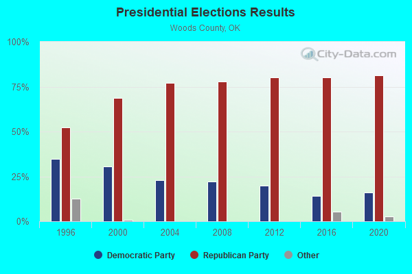
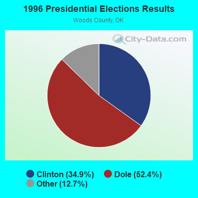
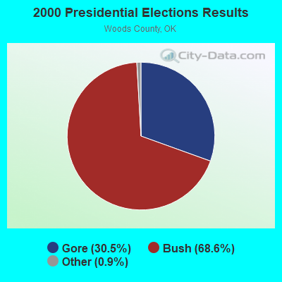
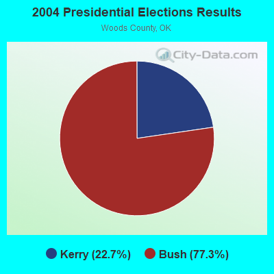
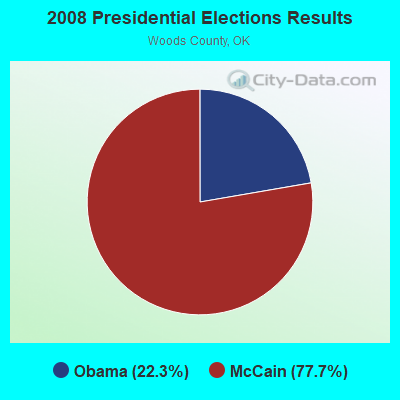
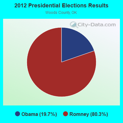
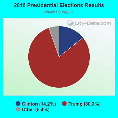
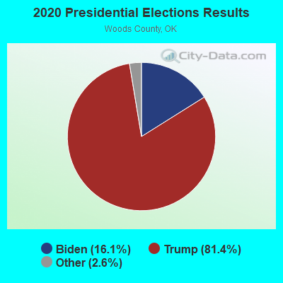
Graphs represent county-level data. Detailed 2008 Election Results
Religion statistics for Avard, OK (based on Woods County data)
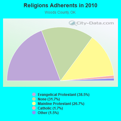
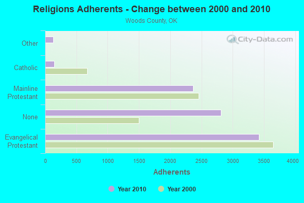
| Religion | Adherents | Congregations |
|---|---|---|
| Evangelical Protestant | 3,417 | 21 |
| Mainline Protestant | 2,368 | 9 |
| Catholic | 148 | 2 |
| Other | 130 | 2 |
| None | 2,815 | - |
Food Environment Statistics:
| Here: | 5.92 / 10,000 pop. |
| Oklahoma: | 1.97 / 10,000 pop. |
| This county: | 1.18 / 10,000 pop. |
| Oklahoma: | 0.20 / 10,000 pop. |
| Woods County: | 1.18 / 10,000 pop. |
| Oklahoma: | 0.76 / 10,000 pop. |
| This county: | 7.10 / 10,000 pop. |
| State: | 4.35 / 10,000 pop. |
| Here: | 7.10 / 10,000 pop. |
| State: | 6.89 / 10,000 pop. |
| Woods County: | 9.3% |
| State: | 10.3% |
| Here: | 27.5% |
| Oklahoma: | 29.2% |
| Local government employment and payroll (March 2007) | |||||
| Function | Full-time employees | Monthly full-time payroll | Average yearly full-time wage | Part-time employees | Monthly part-time payroll |
|---|---|---|---|---|---|
| Hospitals | 0 | $0 | 0 | $0 | |
| Health | 0 | $0 | 0 | $0 | |
| Welfare | 0 | $0 | 0 | $0 | |
| Airports | 0 | $0 | 0 | $0 | |
| Streets and Highways | 0 | $0 | 0 | $0 | |
| Correction | 0 | $0 | 0 | $0 | |
| Fire - Other | 0 | $0 | 0 | $0 | |
| Firefighters | 0 | $0 | 0 | $0 | |
| Police - Other | 0 | $0 | 0 | $0 | |
| Police Protection - Officers | 0 | $0 | 0 | $0 | |
| Judicial and Legal | 0 | $0 | 0 | $0 | |
| Other Government Administration | 0 | $0 | 0 | $0 | |
| Financial Administration | 0 | $0 | 0 | $0 | |
| Other and Unallocable | 0 | $0 | 0 | $0 | |
| Water Supply | 0 | $0 | 0 | $0 | |
| Local Libraries | 0 | $0 | 0 | $0 | |
| Transit | 0 | $0 | 0 | $0 | |
| Water Transport and Terminals | 0 | $0 | 0 | $0 | |
| Natural Resources | 0 | $0 | 0 | $0 | |
| Housing and Community Development (Local) | 0 | $0 | 0 | $0 | |
| Parks and Recreation | 0 | $0 | 0 | $0 | |
| Sewerage | 0 | $0 | 0 | $0 | |
| Gas Supply | 0 | $0 | 0 | $0 | |
| Electric Power | 0 | $0 | 0 | $0 | |
| Solid Waste Management | 0 | $0 | 0 | $0 | |
| Totals for Government | 0 | $0 | 0 | $0 | |
Avard government finances - Expenditure in 2002 (per resident):
- Construction - General: $71,000 ($2958.33)
- Current Operations - Financial Administration: $2,000 ($83.33)
Regular Highways: $1,000 ($41.67)
- Other Capital Outlay - Financial Administration: $1,000 ($41.67)
- Total Salaries and Wages: $1,000 ($41.67)
Avard government finances - Revenue in 2002 (per resident):
- Charges - Other: $1,000 ($41.67)
Solid Waste Management: $0 ($0.00)
- Miscellaneous - General Revenue - Other: $1,000 ($41.67)
Interest Earnings: $1,000 ($41.67)
- State Intergovernmental - Other: $75,000 ($3125.00)
General Support: $1,000 ($41.67)
Highways: $1,000 ($41.67)
- Tax - Public Utilities: $1,000 ($41.67)
Avard government finances - Cash and Securities in 2002 (per resident):
- Other Funds - Cash and Deposits: $9,000 ($375.00)
Strongest AM radio stations in Avard:
- KRMG (740 AM; 50 kW; TULSA, OK; Owner: CXR HOLDINGS, INC.)
- KALV (1430 AM; 0 kW; ALVA, OK; Owner: MM&K OF ALVA, INC.)
- KCRC (1390 AM; 10 kW; ENID, OK; Owner: CHISHOLM TRAIL BROADCASTING CO.)
- KOMA (1520 AM; 50 kW; OKLAHOMA CITY, OK; Owner: RENDA BROADCASTING CORP. OF NEVADA)
- KGYN (1210 AM; 50 kW; GUYMON, OK; Owner: TELNS BROADCASTING COMPANY, INC.)
- KFAQ (1170 AM; 50 kW; TULSA, OK; Owner: JOURNAL BROADCAST CORPORATION)
- KWLS (1290 AM; 5 kW; PRATT, KS; Owner: WAITT RADIO, INC.)
- KFTI (1070 AM; 10 kW; WICHITA, KS; Owner: JOURNAL BROADCAST CORPORATION)
- KRVN (880 AM; 50 kW; LEXINGTON, NE; Owner: NEBRASKA RURAL RADIO ASSOCIATION)
- WHB (810 AM; 50 kW; KANSAS CITY, MO; Owner: UNION BROADCASTING, INC.)
- KTBZ (1430 AM; 25 kW; TULSA, OK; Owner: CLEAR CHANNEL BROADCASTING LICENSES, INC.)
- WBAP (820 AM; 50 kW; FORT WORTH, TX; Owner: WBAP-KSCS OPERATING, LTD.)
- KICA (980 AM; 50 kW; CLOVIS, NM; Owner: BROADCAST ENTERTAINMENT CORPORATION)
Strongest FM radio stations in Avard:
- KQBL (96.9 FM; ENID, OK; Owner: CHAMPLIN BROADCASTING, INC.)
- KNID (99.7 FM; ALVA, OK; Owner: CHRISHOLM TRAIL BROADCASTING COMPANY)
- KWOX (101.1 FM; WOODWARD, OK; Owner: OMNI COMMUNICATIONS, INC.)
- KWFX (93.5 FM; WOODWARD, OK; Owner: CLASSIC COMMUNICATIONS INC)
TV broadcast stations around Avard:
- K60ER (Channel 60; CHEROKEE & ALVA, OK; Owner: SHAFER TRANSLATOR, INC.)
- K62EH (Channel 62; CHEROKEE & ALVA, OK; Owner: SHAFER TRANSLATOR, INC.)
- K64EA (Channel 64; CHEROKEE & ALVA, OK; Owner: SHAFER TRANSLATOR, INC.)
- K56FK (Channel 56; ALVA - CHEROKEE, OK; Owner: SHAFER TRANSLATOR, INC.)
- K58EM (Channel 58; ALVA - CHEROKEE, OK; Owner: SHAFER TRANSLATOR, INC.)
- National Bridge Inventory (NBI) Statistics
- 7Number of bridges
- 66ft / 20.0mTotal length
- $2,336,000Total costs
- 1,930Total average daily traffic
- 259Total average daily truck traffic
- 2,948Total future (year 2040) average daily traffic
FCC Registered Microwave Towers:
1- OK-ALVA-SW-1, Garvin Rd (Lat: 36.710778 Lon: -98.731000), Type: Ltower, Structure height: 36.6 m, Call Sign: WRKX877,
Assigned Frequencies: 11405.0 MHz, 11405.0 MHz, 11405.0 MHz, 11405.0 MHz, 11405.0 MHz, 11405.0 MHz, 11405.0 MHz, 11405.0 MHz, 11405.0 MHz, 11405.0 MHz, Grant Date: 03/02/2021, Expiration Date: 03/02/2031, Certifier: Jack Marsh, Registrant: Amg Technology Investment Group, LLC, 95 Parker Oaks Lane, Hudson Oaks, TX 76087, Phone: (855) 698-5465, Email:


Avard compared to Oklahoma state average:
- Median house value significantly below state average.
- Black race population percentage significantly below state average.
- Hispanic race population percentage significantly below state average.
- Median age above state average.
- Foreign-born population percentage significantly below state average.
- Renting percentage significantly below state average.
- Length of stay since moving in significantly above state average.
- Number of rooms per house above state average.
- House age significantly above state average.
- Number of college students significantly below state average.