Au Sable, New York
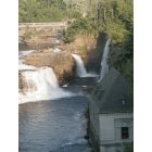
Submit your own pictures of this town and show them to the world
- OSM Map
- Google Map
- MSN Map
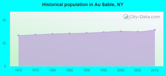
Population change since 2000: +4.3%
 |
| Males: 1,572 | |
| Females: 1,574 |
| Median resident age: | 40.8 years |
| New York median age: | 40.7 years |
Zip codes: 12944.
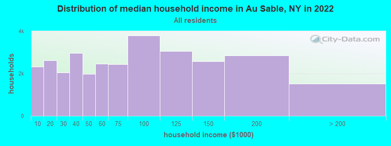
| Au Sable: | $60,953 |
| NY: | $79,557 |
Estimated per capita income in 2022: $30,941 (it was $15,789 in 2000)
Au Sable town income, earnings, and wages data
Estimated median house or condo value in 2022: $148,747 (it was $62,300 in 2000)
| Au Sable: | $148,747 |
| NY: | $400,400 |
Mean prices in 2022: all housing units: $199,088; detached houses: $212,279; townhouses or other attached units: $165,284; in 2-unit structures: $545,537; in 3-to-4-unit structures: $216,109; in 5-or-more-unit structures: $548,924; mobile homes: $82,996
Detailed information about poverty and poor residents in Au Sable, NY

Compare current foreclosures near Au Sable, NY:
| Photo | Address | Area | Beds / Baths | Price | Details |
|---|---|---|---|---|---|

|
#1
New York State Route 86
Jay, NY 12941
|
1,750 sq. feet
|
2 baths 3 beds |
show details | |

|
#2
Turner Rd
Morrisonville, NY 12962
|
- sq. feet
|
- baths - beds |
$37,900
|
show details |

|
#3
Stafford Rd
Plattsburgh, NY 12901
|
1,176 sq. feet
|
1 baths 3 beds |
show details | |

|
#4
State Route 3
Morrisonville, NY 12962
|
1,728 sq. feet
|
3 baths 3 beds |
show details | |

|
#5
Church St
Redford, NY 12978
|
1,088 sq. feet
|
1 baths 3 beds |
show details | |

|
#6
Picketts Corners Rd
Saranac, NY 12981
|
957 sq. feet
|
1 baths 2 beds |
show details | |

|
#7
Patriot Dr
Plattsburgh, NY 12901
|
2,340 sq. feet
|
3 baths 4 beds |
show details | |

|
#8
Mason St
Morrisonville, NY 12962
|
1,004 sq. feet
|
1 baths 2 beds |
show details | |

|
#9
Jersey Swamp Rd
West Chazy, NY 12992
|
1,792 sq. feet
|
2 baths 4 beds |
show details | |

|
#10
Rugar St
Plattsburgh, NY 12901
|
1,316 sq. feet
|
1 baths 4 beds |
show details |
| Photo | Address | Area | Beds / Baths | Price | Details |
|---|---|---|---|---|---|

|
#11
Calkins Rd
Peru, NY 12972
|
1,936 sq. feet
|
2 baths 3 beds |
show details | |

|
#12
State Route 9
Plattsburgh, NY 12901
|
3,314 sq. feet
|
1 baths 4 beds |
show details | |

|
#13
Champlain Dr
Plattsburgh, NY 12901
|
1,116 sq. feet
|
1 baths 3 beds |
show details | |

|
#14
Marie Dr
Plattsburgh, NY 12901
|
2,368 sq. feet
|
1 baths 4 beds |
show details | |

|
#15
Soper St
Morrisonville, NY 12962
|
1,188 sq. feet
|
2 baths 3 beds |
show details | |

|
#16
Beartown Rd
West Chazy, NY 12992
|
3,138 sq. feet
|
2 baths 4 beds |
show details | |

|
#17
Korn Dr
Peru, NY 12972
|
1,404 sq. feet
|
2 baths 4 beds |
show details | |

|
#18
Main Mill St # 2
Plattsburgh, NY 12901
|
1,918 sq. feet
|
2 baths 4 beds |
show details | |

|
#19
Winterbury Lane, Unit 202
Burlington, VT 05401
|
- sq. feet
|
- baths - beds |
show details | |

|
#20
Shelburne Rd # 309
South Burlington, VT 05403
|
- sq. feet
|
- baths - beds |
show details |
| Photo | Address | Area | Beds / Baths | Price | Details |
|---|---|---|---|---|---|

|
#21
W Allen St Apt 35f
Winooski, VT 05404
|
- sq. feet
|
- baths - beds |
show details | |

|
#22
Eastwood Dr Apt 206
South Burlington, VT 05403
|
- sq. feet
|
- baths - beds |
show details | |

|
#23
Ross Way
Essex, NY 12936
|
- sq. feet
|
- baths - beds |
show details | |

|
#24
Us Route 2
Grand Isle, VT 05458
|
- sq. feet
|
- baths - beds |
show details | |

|
#25
Webster Rd
Shelburne, VT 05482
|
- sq. feet
|
- baths - beds |
show details | |

|
#26
Pine St Apt 2
Burlington, VT 05401
|
- sq. feet
|
- baths - beds |
show details | |

|
#27
Elmwood Ave Apt 8
Burlington, VT 05401
|
- sq. feet
|
- baths - beds |
show details | |

|
#28
Lozier Pl Apt A
Plattsburgh, NY 12901
|
- sq. feet
|
- baths - beds |
show details | |

|
#29
Seth Sq
Plattsburgh, NY 12901
|
- sq. feet
|
- baths - beds |
show details | |

|
#30
Ferris Ct
Plattsburgh, NY 12901
|
- sq. feet
|
- baths - beds |
show details |
| Photo | Address | Area | Beds / Baths | Price | Details |
|---|---|---|---|---|---|

|
#31
Sonya Way
Plattsburgh, NY 12901
|
- sq. feet
|
- baths - beds |
show details | |

|
#32
Military Tpke
Plattsburgh, NY 12901
|
980 sq. feet
|
- baths - beds |
show details | |

|
#33
Silver Lake Rd
Au Sable Forks, NY 12912
|
- sq. feet
|
- baths - beds |
show details | |

|
#34
Evergreen St
Plattsburgh, NY 12901
|
- sq. feet
|
- baths - beds |
show details | |

|
#35
Sharron Ave
Plattsburgh, NY 12901
|
- sq. feet
|
- baths - beds |
show details | |

|
#36
Evergreen Ln
Jay, NY 12941
|
- sq. feet
|
- baths - beds |
show details | |

|
#37
Wolfe Way Apt 50
Plattsburgh, NY 12901
|
- sq. feet
|
- baths - beds |
show details | |

|
#38
Franklin Sq
Burlington, VT 05408
|
- sq. feet
|
- baths - beds |
show details | |

|
#39
Sandra Cir
Burlington, VT 05408
|
- sq. feet
|
- baths - beds |
show details | |

|
#40
Sailly Ave
Plattsburgh, NY 12901
|
- sq. feet
|
- baths - beds |
show details |
| Photo | Address | Area | Beds / Baths | Price | Details |
|---|---|---|---|---|---|

|
#41
Clark Rd
Peru, NY 12972
|
- sq. feet
|
- baths - beds |
show details | |

|
#42
Williston Rd
South Burlington, VT 05403
|
- sq. feet
|
- baths - beds |
show details | |

|
#43
Shady Ln
Colchester, VT 05446
|
- sq. feet
|
- baths - beds |
show details | |

|
#44
Lafountain St
Winooski, VT 05404
|
- sq. feet
|
- baths - beds |
show details | |

|
#45
Edgewood Dr
Colchester, VT 05446
|
- sq. feet
|
- baths - beds |
show details | |

|
#46
Bayview St
Burlington, VT 05401
|
- sq. feet
|
- baths - beds |
show details | |

|
Check over 1 million property listings on Foreclosure.com!
|
browse all offers | |||

- 3,00695.5%White alone
- 481.5%Hispanic
- 451.4%Two or more races
- 240.8%Black alone
- 170.5%Asian alone
- 60.2%American Indian alone
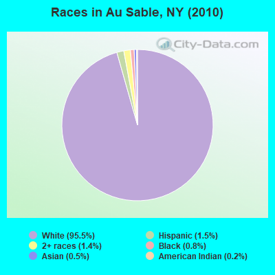
Races in Au Sable detailed stats: ancestries, foreign born residents, place of birth
 Recent articles from our blog. Our writers, many of them Ph.D. graduates or candidates, create easy-to-read articles on a wide variety of topics.
Ancestries: French (23.4%), English (13.9%), Irish (13.2%), French Canadian (9.6%), United States (8.6%), German (5.8%).
Current Local Time: EST time zone
Land area: 39.1 square miles.
Population density: 80 people per square mile (very low).
73 residents are foreign born (1.2% North America, 1.0% Europe).
| This town: | 2.4% |
| New York: | 20.4% |
| Au Sable town: | 2.1% ($1,283) |
| New York: | 1.9% ($2,847) |
Nearest city with pop. 50,000+: Schenectady, NY  (120.4 miles , pop. 61,821).
Nearest city with pop. 200,000+: Boston, MA (194.7 miles , pop. 589,141).
Nearest city with pop. 1,000,000+: Bronx, NY (254.6 miles , pop. 1,332,650).
Nearest cities:
), ), ), Latitude: 44.52 N, Longitude: 73.51 W
Area code commonly used in this area: 518
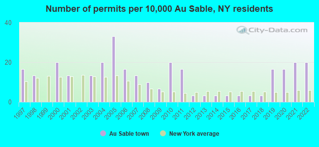
Single-family new house construction building permits:
- 2022: 6 buildings, average cost: $160,000
- 2021: 6 buildings, average cost: $160,000
- 2020: 5 buildings, average cost: $160,000
- 2019: 5 buildings, average cost: $110,600
- 2018: 1 building, cost: $200,000
- 2017: 1 building, cost: $200,000
- 2016: 1 building, cost: $200,000
- 2015: 1 building, cost: $200,000
- 2014: 1 building, cost: $200,000
- 2013: 1 building, cost: $200,000
- 2012: 1 building, cost: $200,000
- 2011: 5 buildings, average cost: $153,000
- 2010: 6 buildings, average cost: $143,300
- 2009: 2 buildings, average cost: $200,000
- 2008: 3 buildings, average cost: $200,000
- 2007: 4 buildings, average cost: $200,000
- 2006: 5 buildings, average cost: $200,000
- 2005: 10 buildings, average cost: $80,000
- 2004: 6 buildings, average cost: $158,200
- 2003: 4 buildings, average cost: $280,800
- 2001: 4 buildings, average cost: $113,800
- 2000: 6 buildings, average cost: $41,700
- 1998: 4 buildings, average cost: $84,300
- 1997: 5 buildings, average cost: $59,200
| Here: | 4.0% |
| New York: | 4.4% |
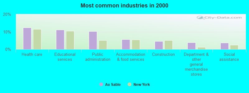
- Health care (12.4%)
- Educational services (11.2%)
- Public administration (10.3%)
- Accommodation & food services (5.6%)
- Construction (4.7%)
- Department & other general merchandise stores (4.0%)
- Social assistance (3.7%)
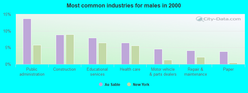
- Public administration (13.7%)
- Construction (8.8%)
- Educational services (7.9%)
- Health care (6.4%)
- Motor vehicle & parts dealers (4.6%)
- Repair & maintenance (4.1%)
- Paper (3.8%)
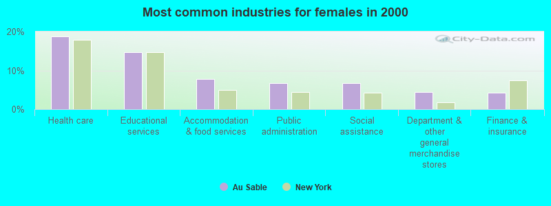
- Health care (18.7%)
- Educational services (14.7%)
- Accommodation & food services (7.8%)
- Public administration (6.7%)
- Social assistance (6.7%)
- Department & other general merchandise stores (4.5%)
- Finance & insurance (4.3%)
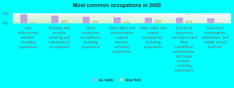
- Law enforcement workers, including supervisors (5.7%)
- Building and grounds cleaning and maintenance occupations (5.0%)
- Other production occupations, including supervisors (4.1%)
- Other office and administrative support workers, including supervisors (3.9%)
- Other sales and related occupations, including supervisors (3.6%)
- Electrical equipment mechanics and other installation, maintenance, and repair workers, including supervisors (3.6%)
- Preschool, kindergarten, elementary, and middle school teachers (3.2%)
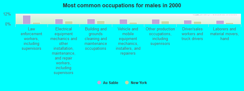
- Law enforcement workers, including supervisors (10.4%)
- Electrical equipment mechanics and other installation, maintenance, and repair workers, including supervisors (6.2%)
- Building and grounds cleaning and maintenance occupations (6.1%)
- Vehicle and mobile equipment mechanics, installers, and repairers (5.9%)
- Other production occupations, including supervisors (5.8%)
- Driver/sales workers and truck drivers (4.9%)
- Laborers and material movers, hand (4.4%)
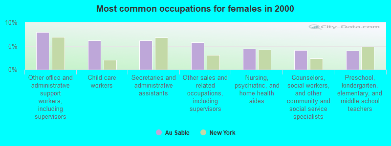
- Other office and administrative support workers, including supervisors (8.0%)
- Child care workers (6.2%)
- Secretaries and administrative assistants (6.2%)
- Other sales and related occupations, including supervisors (5.8%)
- Nursing, psychiatric, and home health aides (4.5%)
- Counselors, social workers, and other community and social service specialists (4.2%)
- Preschool, kindergarten, elementary, and middle school teachers (4.0%)
Average climate in Au Sable, New York
Based on data reported by over 4,000 weather stations


(lower is better)
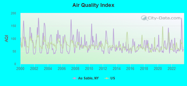
Air Quality Index (AQI) level in 2023 was 80.9. This is about average.
| City: | 80.9 |
| U.S.: | 72.6 |
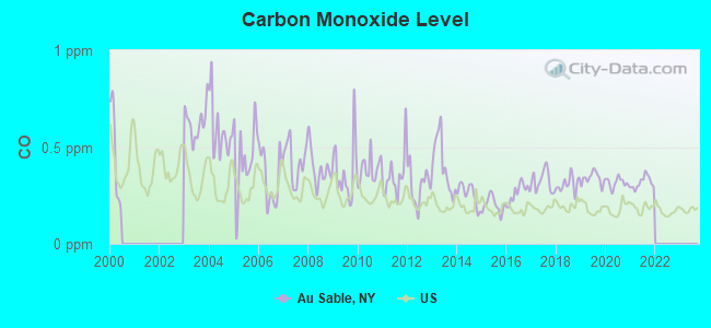
Carbon Monoxide (CO) [ppm] level in 2021 was 0.317. This is worse than average. Closest monitor was 15.2 miles away from the city center.
| City: | 0.317 |
| U.S.: | 0.251 |
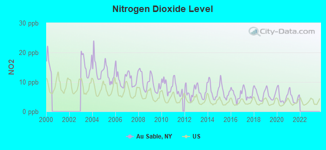
Nitrogen Dioxide (NO2) [ppb] level in 2021 was 4.81. This is about average. Closest monitor was 15.2 miles away from the city center.
| City: | 4.81 |
| U.S.: | 5.11 |
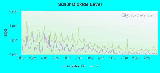
Sulfur Dioxide (SO2) [ppb] level in 2023 was 0.100. This is significantly better than average. Closest monitor was 15.2 miles away from the city center.
| City: | 0.100 |
| U.S.: | 1.515 |
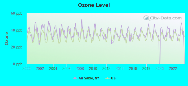
Ozone [ppb] level in 2023 was 39.4. This is about average. Closest monitor was 15.2 miles away from the city center.
| City: | 39.4 |
| U.S.: | 33.3 |
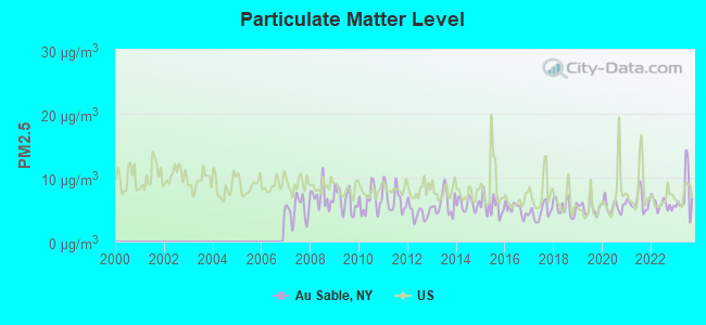
Particulate Matter (PM2.5) [µg/m3] level in 2023 was 7.31. This is about average. Closest monitor was 15.0 miles away from the city center.
| City: | 7.31 |
| U.S.: | 8.11 |
Earthquake activity:
Au Sable-area historical earthquake activity is significantly above New York state average. It is 71% smaller than the overall U.S. average.On 4/20/2002 at 10:50:47, a magnitude 5.3 (5.3 ML, Depth: 3.0 mi, Class: Moderate, Intensity: VI - VII) earthquake occurred 9.1 miles away from Au Sable center
On 4/20/2002 at 10:50:47, a magnitude 5.2 (5.2 MB, 4.2 MS, 5.2 MW, 5.0 MW) earthquake occurred 10.3 miles away from Au Sable center
On 10/7/1983 at 10:18:46, a magnitude 5.3 (5.1 MB, 5.3 LG, 5.1 ML) earthquake occurred 56.7 miles away from the city center
On 1/19/1982 at 00:14:42, a magnitude 4.7 (4.5 MB, 4.7 MD, 4.5 LG, Class: Light, Intensity: IV - V) earthquake occurred 118.4 miles away from the city center
On 10/16/2012 at 23:12:25, a magnitude 4.7 (4.7 ML, Depth: 10.0 mi) earthquake occurred 155.7 miles away from the city center
On 4/20/2002 at 11:04:42, a magnitude 3.7 (3.7 ML, Depth: 3.1 mi, Class: Light, Intensity: II - III) earthquake occurred 8.9 miles away from the city center
Magnitude types: regional Lg-wave magnitude (LG), body-wave magnitude (MB), duration magnitude (MD), local magnitude (ML), surface-wave magnitude (MS), moment magnitude (MW)
Natural disasters:
The number of natural disasters in Clinton County (15) is near the US average (15).Major Disasters (Presidential) Declared: 9
Emergencies Declared: 5
Causes of natural disasters: Floods: 5, Storms: 5, Hurricanes: 3, Winter Storms: 2, Blizzard: 1, Earthquake: 1, Power Outage: 1, Snowstorm: 1, Tornado: 1, Wind: 1, Other: 2 (Note: some incidents may be assigned to more than one category).
Hospitals and medical centers near Au Sable:
- CLINTON COUNTY NURSING HOME (Nursing Home, about 12 miles away; PLATTSBURGH, NY)
- EVERGREEN VALLEY NURSING HOME (Nursing Home, about 12 miles away; PLATTSBURGH, NY)
- STARR FARM NURSING CENTER (Nursing Home, about 13 miles away; BURLINGTON, VT)
- KINDRED TRANSITIONAL CARE AND REHAB BIRCHWOOD TER (Nursing Home, about 13 miles away; BURLINGTON, VT)
- MEADOWBROOK HEALTHCARE (Nursing Home, about 13 miles away; PLATTSBURGH, NY)
- HOSPICE OF THE NORTH COUNTRY INC (Hospital, about 13 miles away; PLATTSBURGH, NY)
- CVPH MEDICAL CENTER RENAL CENTER (Dialysis Facility, about 13 miles away; PLATTSBURGH, NY)
Amtrak stations near Au Sable:
- 6 miles: PORT KENT (RTE. 9 NORTH) - Seasonal Station . Services: free short-term parking, call for taxi service.
- 13 miles: PLATTSBURGH (BRIDGE ST.) . Services: enclosed waiting area, public restrooms, public payphones, free short-term parking, free long-term parking, call for car rental service, call for taxi service.
- 20 miles: BURLINGTON-ESSEX JUNCTION (ESSEX JUNCTION, 29 RAILROAD AVE.) . Services: ticket office, partially wheelchair accessible, enclosed waiting area, public restrooms, public payphones, vending machines, ATM, free short-term parking, free long-term parking, call for car rental service, call for taxi service, public transit connection.
Colleges/universities with over 2000 students nearest to Au Sable:
- SUNY College at Plattsburgh (about 13 miles; Plattsburgh, NY; Full-time enrollment: 5,934)
- Champlain College (about 16 miles; Burlington, VT; FT enrollment: 2,623)
- University of Vermont (about 16 miles; Burlington, VT; FT enrollment: 11,566)
- Community College of Vermont (about 17 miles; Winooski, VT; FT enrollment: 3,394)
- Saint Michael's College (about 18 miles; Colchester, VT; FT enrollment: 2,336)
- Middlebury College (about 40 miles; Middlebury, VT; FT enrollment: 3,077)
- Norwich University (about 50 miles; Northfield, VT; FT enrollment: 4,221)
Points of interest:
Notable locations in Au Sable: Ausable Beach (A), Hart Apple Farms (B), Adirondack Farms (C), Keeseville Fire Station (D). Display/hide their locations on the map
Churches in Au Sable include: Church of the Nazarene (A), Good Shepherd Church (B), Independent Baptist Church of Keeseville (C), Kingdom Hall of Jehovahs Witnesses (D). Display/hide their locations on the map
Cemeteries: Riverview Cemetery (1), Saint Johns Cemetery (2), Evergreen Cemetery (3), McCormick Cemetery (4), Quaker Cemetery (5). Display/hide their locations on the map
Streams, rivers, and creeks: Furnace Brook (A), Southwick Brook (B), Caldwell Brook (C). Display/hide their locations on the map
| This town: | 2.4 people |
| New York: | 2.6 people |
| This town: | 65.7% |
| Whole state: | 63.5% |
| This town: | 10.8% |
| Whole state: | 6.8% |
Likely homosexual households (counted as self-reported same-sex unmarried-partner households)
- Lesbian couples: 0.5% of all households
- Gay men: 0.2% of all households
| This town: | 12.0% |
| Whole state: | 14.6% |
| This town: | 6.1% |
| Whole state: | 7.4% |
24 people in homes for the mentally retarded in 2000
For population 15 years and over in Au Sable:
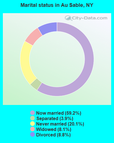
- Never married: 20.1%
- Now married: 59.2%
- Separated: 3.9%
- Widowed: 8.1%
- Divorced: 8.8%
For population 25 years and over in Au Sable:
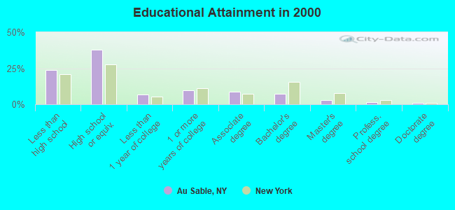
- High school or higher: 76.1%
- Bachelor's degree or higher: 12.7%
- Graduate or professional degree: 5.6%
- Unemployed: 8.4%
- Mean travel time to work (commute): 24.8 minutes
| Here: | 13.1 |
| New York average: | 14.2 |
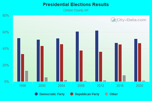
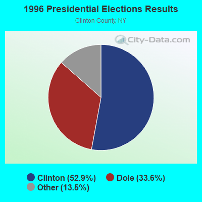
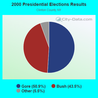
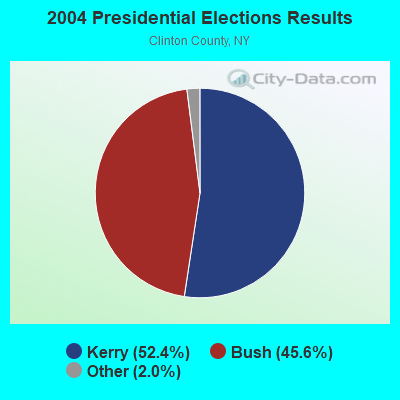
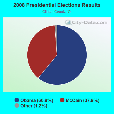
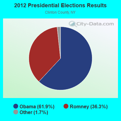
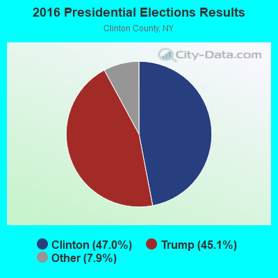
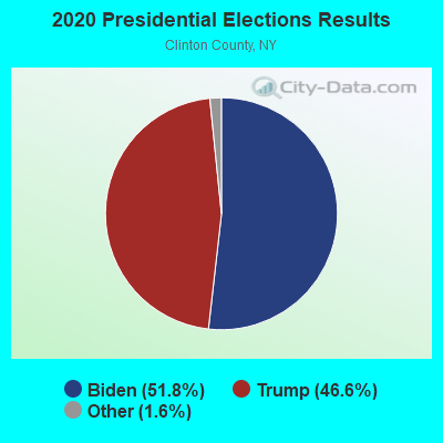
Graphs represent county-level data. Detailed 2008 Election Results
Religion statistics for Au Sable, NY (based on Clinton County data)
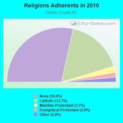
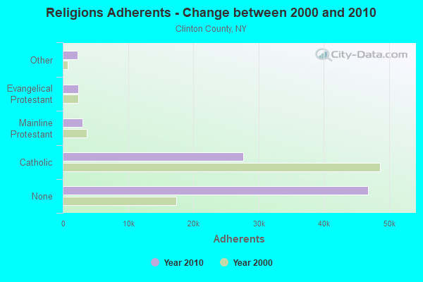
| Religion | Adherents | Congregations |
|---|---|---|
| Catholic | 27,695 | 31 |
| Mainline Protestant | 3,038 | 21 |
| Evangelical Protestant | 2,417 | 21 |
| Other | 2,266 | 7 |
| None | 46,712 | - |
Food Environment Statistics:
| This county: | 2.92 / 10,000 pop. |
| New York: | 4.13 / 10,000 pop. |
| Clinton County: | 0.12 / 10,000 pop. |
| New York: | 0.06 / 10,000 pop. |
| Here: | 0.61 / 10,000 pop. |
| State: | 0.92 / 10,000 pop. |
| Clinton County: | 6.21 / 10,000 pop. |
| New York: | 1.68 / 10,000 pop. |
| Clinton County: | 8.90 / 10,000 pop. |
| New York: | 8.82 / 10,000 pop. |
| This county: | 7.3% |
| New York: | 8.2% |
| This county: | 25.4% |
| New York: | 23.8% |
| Clinton County: | 13.4% |
| New York: | 15.6% |
Strongest AM radio stations in Au Sable:
- WEAV (960 AM; 5 kW; PLATTSBURGH, NY; Owner: CLEAR CHANNEL BROADCASTING LICENSES, INC.)
- WTWK (1070 AM; daytime; 5 kW; PLATTSBURGH, NY; Owner: CHAMPLAIN COMMUNICATIONS CORPORATION)
- WCHP (760 AM; 35 kW; CHAMPLAIN, NY; Owner: CHAMPLAIN RADIO, INC.)
- WVMT (620 AM; 5 kW; BURLINGTON, VT; Owner: SISON BROADCASTING, INC.)
- WICY (1490 AM; 50 kW; MALONE, NY; Owner: CARTIER COMMUNICATIONS INC.)
- WVAA (1390 AM; 5 kW; BURLINGTON, VT; Owner: RADIO VERMONT, KDR, LLC)
- WIRD (920 AM; 5 kW; LAKE PLACID, NY; Owner: RADIO LAKE PLACID INC)
- WDEV (550 AM; 5 kW; WATERBURY, VT; Owner: RADIO VERMONT, INC.)
- WIRY (1340 AM; 1 kW; PLATTSBURGH, NY; Owner: HOMETOWN RADIO INC)
- WGY (810 AM; 50 kW; SCHENECTADY, NY; Owner: CLEAR CHANNEL BROADCASTING LICENSES, INC.)
- WJOY (1230 AM; 1 kW; BURLINGTON, VT; Owner: HALL COMMUNICATIONS, INC.)
- WNNZ (640 AM; 50 kW; WESTFIELD, MA; Owner: CLEAR CHANNEL BROADCASTING LICENSES, INC.)
- WPTR (1540 AM; 50 kW; ALBANY, NY; Owner: KIMTRON, INC.)
Strongest FM radio stations in Au Sable:
- WKOL (105.1 FM; PLATTSBURGH, NY; Owner: HALL COMMUNICATIONS, INC.)
- WXLU (88.3 FM; PERU, NY; Owner: THE ST. LAWRENCE UNIVERSITY)
- WCEL (91.9 FM; PLATTSBURGH, NY; Owner: WAMC)
- WEZF (92.9 FM; BURLINGTON, VT; Owner: CAPSTAR TX LIMITED PARTNERSHIP)
- WVPS (107.9 FM; BURLINGTON, VT; Owner: VERMONT PUBLIC RADIO)
- WCVT (101.7 FM; STOWE, VT; Owner: RADIO VERMONT CLASSICS, L.L.C.)
- WLKC (103.3 FM; WATERBURY, VT; Owner: RADIO BROADCASTING SERVICES, INC.)
- WBTZ (99.9 FM; PLATTSBURGH, NY; Owner: PLATTSBURGH BROADCASTING CORPORATION)
- WNCS (104.7 FM; MONTPELIER, VT; Owner: MONTPELIER BROADCASTING, INC.)
- WDEV-FM (96.1 FM; WARREN, VT; Owner: RADIO VERMONT, INC.)
- WCPV (101.3 FM; ESSEX, NY; Owner: CAPSTAR TX LIMITED PARTNERSHIP)
- WYUL (94.7 FM; CHATEAUGAY, NY; Owner: CARTIER COMMUNICATIONS INC.)
- WXZO (96.7 FM; WILLSBORO, NY; Owner: CAPSTAR TX LIMITED PARTNERSHIP)
- WIZN (106.7 FM; VERGENNES, VT; Owner: BURLINGTON BROADCASTERS, INC.)
- WGLY-FM (91.5 FM; BOLTON, VT; Owner: CHRISTIAN MINISTRIES, INC.)
- WLFE-FM (102.3 FM; ST. ALBANS, VT; Owner: CHAMPLAIN COMMUNICATIONS CORP.)
- WEBK (105.3 FM; KILLINGTON, VT; Owner: 6 JOHNSON ROAD LICENSES, INC.)
- WJJR (98.1 FM; RUTLAND, VT; Owner: 6 JOHNSON ROAD LICENSES, INC.)
- WZRT (97.1 FM; RUTLAND, VT; Owner: CAPSTAR TX LIMITED PARTNERSHIP)
- WOKO (98.9 FM; BURLINGTON, VT; Owner: HALL COMMUNICATIONS, INC.)
TV broadcast stations around Au Sable:
- WPTZ (Channel 5; NORTH POLE, NY; Owner: HEARST-ARGYLE STATIONS, INC.)
- WCFE-TV (Channel 57; PLATTSBURGH, NY; Owner: MOUNTAIN LAKE PUBLIC TELEVISION COUNCIL)
- W16AL (Channel 16; BURLINGTON, VT; Owner: TRINITY BROADCASTING NETWORK)
- W19BR (Channel 19; MONKTON, VT; Owner: PLATTSBURGH PARTNERS)
- National Bridge Inventory (NBI) Statistics
- 17Number of bridges
- 144ft / 43.5mTotal length
- $27,466,000Total costs
- 50,061Total average daily traffic
- 2,947Total average daily truck traffic
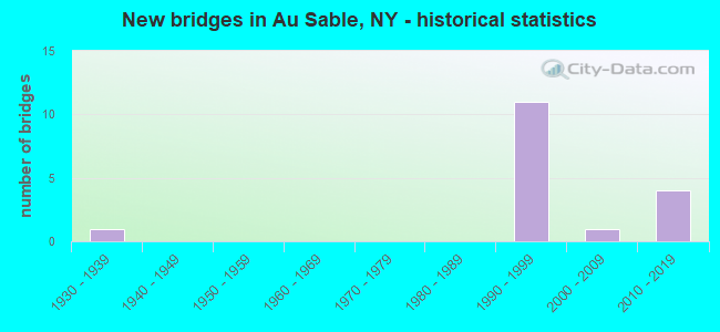
- New bridges - historical statistics
- 11930-1939
- 111990-1999
- 12000-2009
- 42010-2019
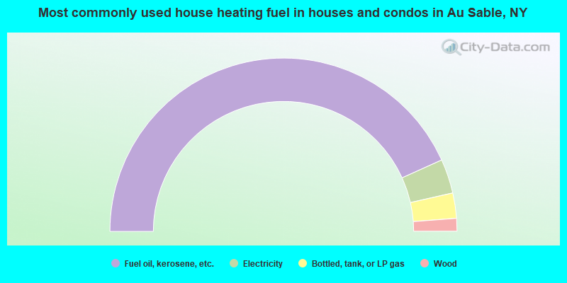
- 86.5%Fuel oil, kerosene, etc.
- 6.4%Electricity
- 4.7%Bottled, tank, or LP gas
- 2.4%Wood

- 59.0%Fuel oil, kerosene, etc.
- 24.3%Electricity
- 14.1%Bottled, tank, or LP gas
- 2.6%Wood
Au Sable compared to New York state average:
- Median house value significantly below state average.
- Unemployed percentage below state average.
- Black race population percentage significantly below state average.
- Hispanic race population percentage significantly below state average.
- Foreign-born population percentage significantly below state average.
- Renting percentage below state average.
- Length of stay since moving in significantly above state average.
- Number of rooms per house significantly below state average.
- House age significantly below state average.
- Percentage of population with a bachelor's degree or higher below state average.