Ashwood, Oregon
Submit your own pictures of this place and show them to the world
- OSM Map
- General Map
- Google Map
- MSN Map

| Males: 258 | |
| Females: 223 |
| Median resident age: | 41.0 years |
| Oregon median age: | 36.3 years |
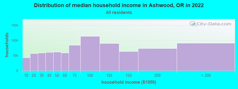
| Ashwood: | $77,518 |
| OR: | $75,657 |
Estimated per capita income in 2022: $37,806 (it was $18,866 in 2000)
Ashwood CCD income, earnings, and wages data
Estimated median house or condo value in 2022: $623,425 (it was $181,800 in 2000)
| Ashwood: | $623,425 |
| OR: | $475,600 |
Mean prices in 2022: all housing units: $386,783; detached houses: $414,717; townhouses or other attached units: $417,505; mobile homes: $279,819; occupied boats, rvs, vans, etc.: $29,680
Detailed information about poverty and poor residents in Ashwood, OR
Compare current foreclosures near Ashwood, OR:
| Photo | Address | Area | Beds / Baths | Price | Details |
|---|---|---|---|---|---|

|
#1
NW Country Loop
Prineville, OR 97754
|
2,024 sq. feet
|
2 baths 3 beds |
show details | |

|
#2
NW Jordan Ave
Prineville, OR 97754
|
1,839 sq. feet
|
2 baths 3 beds |
show details | |

|
#3
NW Grizzly Mt Rd
Prineville, OR 97754
|
2,384 sq. feet
|
3 baths 5 beds |
show details | |

|
#4
NW Overlook Ln
Prineville, OR 97754
|
1,320 sq. feet
|
1 baths 2 beds |
show details | |

|
#5
8th St
Madras, OR 97741
|
- sq. feet
|
- baths - beds |
show details | |

|
#6
SE E St
Madras, OR 97741
|
- sq. feet
|
- baths - beds |
show details | |

|
#7
Freedom Ln
Madras, OR 97741
|
- sq. feet
|
- baths - beds |
show details | |

|
#8
SW Kenwood Dr
Madras, OR 97741
|
- sq. feet
|
- baths - beds |
show details | |

|
#9
NW Commercial St
Madras, OR 97741
|
- sq. feet
|
- baths - beds |
show details | |

|
#10
SW Roosevelt St Unit 56
Madras, OR 97741
|
- sq. feet
|
- baths - beds |
show details |
| Photo | Address | Area | Beds / Baths | Price | Details |
|---|---|---|---|---|---|

|
#11
SW G St Apt C
Madras, OR 97741
|
- sq. feet
|
- baths - beds |
show details | |

|
#12
NW Grizzly Mt Rd
Prineville, OR 97754
|
456 sq. feet
|
- baths - beds |
show details | |

|
#13
SE Maui Ln
Madras, OR 97741
|
- sq. feet
|
- baths - beds |
show details | |

|
#14
SW 3rd St
Madras, OR 97741
|
- sq. feet
|
- baths - beds |
show details | |

|
#15
SW 2nd St
Madras, OR 97741
|
- sq. feet
|
- baths - beds |
show details | |

|
#16
SW Grant St
Madras, OR 97741
|
- sq. feet
|
- baths - beds |
show details | |

|
#17
SW Madison St
Madras, OR 97741
|
- sq. feet
|
- baths - beds |
show details | |

|
#18
NW Depot Rd Unit 18
Madras, OR 97741
|
- sq. feet
|
- baths - beds |
show details | |

|
#19
NE 7th St
Madras, OR 97741
|
- sq. feet
|
- baths - beds |
show details | |

|
#20
SW Hatfield St
Madras, OR 97741
|
- sq. feet
|
- baths - beds |
show details |
| Photo | Address | Area | Beds / Baths | Price | Details |
|---|---|---|---|---|---|

|
#21
SW Roosevelt St Unit 20
Madras, OR 97741
|
- sq. feet
|
- baths - beds |
show details | |

|
#22
SE 9th St
Madras, OR 97741
|
- sq. feet
|
- baths - beds |
show details | |

|
#23
SE 10th St
Madras, OR 97741
|
- sq. feet
|
- baths - beds |
show details | |

|
#24
NE Plaza Pl
Madras, OR 97741
|
- sq. feet
|
- baths - beds |
show details | |

|
#25
SW Lorraine Dr
Madras, OR 97741
|
- sq. feet
|
- baths - beds |
show details | |

|
#26
SW Bear Dr
Madras, OR 97741
|
- sq. feet
|
- baths - beds |
show details | |

|
#27
SE Strawberry Ln
Madras, OR 97741
|
- sq. feet
|
- baths - beds |
show details | |

|
#28
NE Loucks Rd
Madras, OR 97741
|
- sq. feet
|
- baths - beds |
show details | |

|
Check over 1 million property listings on Foreclosure.com!
|
browse all offers | |||

- 39387.7%White alone
- 368.0%Hispanic
- 102.2%Two or more races
- 61.3%Native Hawaiian and Other
Pacific Islander alone - 20.4%Black alone
- 10.2%American Indian alone
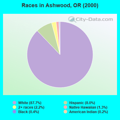
Races in Ashwood detailed stats: ancestries, foreign born residents, place of birth
 Recent articles from our blog. Our writers, many of them Ph.D. graduates or candidates, create easy-to-read articles on a wide variety of topics.

Current Local Time: PST time zone
Elevation: 2523 feet
Land area: 757.8 square miles.
Population density: 0.6 people per square mile (very low).

| Ashwood CCD: | 0.8% ($1,381) |
| Oregon: | 1.2% ($1,687) |
Nearest city with pop. 50,000+: Bend, OR  (43.5 miles , pop. 52,029).
Nearest city with pop. 200,000+: Northwest Clackamas, OR (102.7 miles , pop. 224,220).
Nearest city with pop. 1,000,000+: Los Angeles, CA (738.7 miles , pop. 3,694,820).
Nearest cities:
), ), Latitude: 44.59 N, Longitude: 120.85 W
Area code commonly used in this area: 541

| Here: | 4.8% |
| Oregon: | 3.9% |
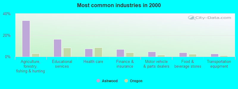
- Agriculture, forestry, fishing & hunting (33.6%)
- Educational services (16.4%)
- Health care (7.5%)
- Finance & insurance (7.0%)
- Motor vehicle & parts dealers (4.7%)
- Food & beverage stores (3.7%)
- Transportation equipment (2.8%)
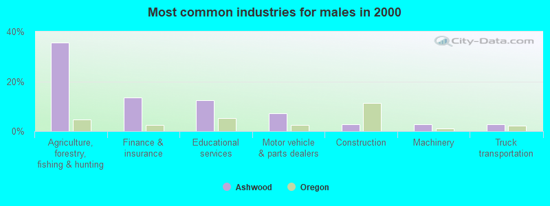
- Agriculture, forestry, fishing & hunting (35.7%)
- Finance & insurance (13.4%)
- Educational services (12.5%)
- Motor vehicle & parts dealers (7.1%)
- Construction (2.7%)
- Machinery (2.7%)
- Truck transportation (2.7%)
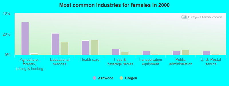
- Agriculture, forestry, fishing & hunting (31.4%)
- Educational services (20.6%)
- Health care (13.7%)
- Food & beverage stores (5.9%)
- Transportation equipment (3.9%)
- Public administration (3.9%)
- U. S. Postal service (3.9%)

- Agricultural workers, including supervisors (14.5%)
- Farmers and farm managers (12.6%)
- Building and grounds cleaning and maintenance occupations (7.0%)
- Other financial specialists (7.0%)
- Preschool, kindergarten, elementary, and middle school teachers (6.5%)
- Registered nurses (6.5%)
- Driver/sales workers and truck drivers (4.2%)

- Farmers and farm managers (14.3%)
- Agricultural workers, including supervisors (14.3%)
- Other financial specialists (13.4%)
- Building and grounds cleaning and maintenance occupations (12.5%)
- Driver/sales workers and truck drivers (8.0%)
- Other material moving workers, except laborers (3.6%)
- Other management occupations, except farmers and farm managers (2.7%)

- Agricultural workers, including supervisors (14.7%)
- Preschool, kindergarten, elementary, and middle school teachers (13.7%)
- Registered nurses (13.7%)
- Farmers and farm managers (10.8%)
- Information and record clerks, except customer service representatives (5.9%)
- Other office and administrative support workers, including supervisors (5.9%)
- Other sales and related occupations, including supervisors (4.9%)
Average climate in Ashwood, Oregon
Based on data reported by over 4,000 weather stations


(lower is better)
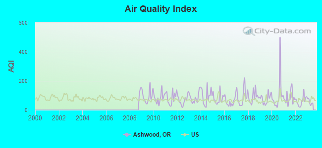
Air Quality Index (AQI) level in 2022 was 62.7. This is about average.
| City: | 62.7 |
| U.S.: | 72.6 |
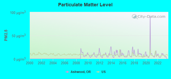
Particulate Matter (PM2.5) [µg/m3] level in 2022 was 6.74. This is better than average. Closest monitor was 20.4 miles away from the city center.
| City: | 6.74 |
| U.S.: | 8.11 |
Earthquake activity:
Ashwood-area historical earthquake activity is significantly above Oregon state average. It is 2323% greater than the overall U.S. average.On 10/3/1915 at 06:52:48, a magnitude 7.6 (7.6 UK, Class: Major, Intensity: VIII - XII) earthquake occurred 330.7 miles away from the city center
On 4/13/1949 at 19:55:42, a magnitude 7.0 (7.0 UK) earthquake occurred 200.0 miles away from Ashwood center, causing $80,000,000 total damage
On 1/31/1922 at 13:17:28, a magnitude 7.6 (7.6 UK) earthquake occurred 360.1 miles away from the city center
On 2/28/2001 at 18:54:32, a magnitude 6.8 (6.5 MB, 6.6 MS, 6.8 MW, Class: Strong, Intensity: VII - IX) earthquake occurred 191.6 miles away from the city center, causing $2,000,000,000 total damage and $305,000,000 insured losses
On 2/28/2001 at 18:54:32, a magnitude 6.8 (6.8 MD, Depth: 32.2 mi) earthquake occurred 198.4 miles away from Ashwood center
On 11/8/1980 at 10:27:34, a magnitude 7.2 (6.2 MB, 7.2 MS, 7.2 MW, 7.0 ML) earthquake occurred 297.7 miles away from the city center
Magnitude types: body-wave magnitude (MB), duration magnitude (MD), local magnitude (ML), surface-wave magnitude (MS), moment magnitude (MW)
Natural disasters:
The number of natural disasters in Jefferson County (12) is smaller than the US average (15).Major Disasters (Presidential) Declared: 5
Emergencies Declared: 2
Causes of natural disasters: Fires: 4, Floods: 4, Landslides: 2, Mudslides: 2, Storms: 2, Winter Storms: 2, Drought: 1, Heavy Rain: 1, Hurricane: 1, Wind: 1, Other: 1 (Note: some incidents may be assigned to more than one category).
Colleges/universities with over 2000 students nearest to Ashwood:
- Central Oregon Community College (about 44 miles; Bend, OR; Full-time enrollment: 5,217)
- Clackamas Community College (about 99 miles; Oregon City, OR; FT enrollment: 4,261)
- Mt Hood Community College (about 99 miles; Gresham, OR; FT enrollment: 11,847)
- Pioneer Pacific College (about 107 miles; Wilsonville, OR; FT enrollment: 2,194)
- Lewis & Clark College (about 107 miles; Portland, OR; FT enrollment: 2,864)
- Chemeketa Community College (about 108 miles; Salem, OR; FT enrollment: 10,746)
- Portland Community College (about 109 miles; Portland, OR; FT enrollment: 23,600)
Public elementary/middle school in Ashwood:
- ASHWOOD ELEMENTARY SCHOOL (Students: 2, Location: 18624 NE MAIN, Grades: KG-6)
Points of interest:
Notable locations in Ashwood: Jumpoff Joe (A), Hay Creek Ranch (B), Morrow Ranch (C), McCoin Orchard (D), Fox Corral (E), Rock Fort (F), Heisler Station (G), McCoin Orchard (H), Pine Ridge Corral (I), Cherry Creek Ranch (J), Haystack West Boat Ramp (K), Haystack Campground Boat Ramp (L), Haystack Reservoir Recreation Site (M), Roundup Grounds (N), Upper Cherry Creek Ranch (O), Ludwick Cabin (P), Black Place (Q), Norton Ranch (R), Haystack West Shore Recreation Site (S), Cyrus Horse Camp (T). Display/hide their locations on the map
Cemeteries: Woods Cemetery (1), Gray Butte Cemetery (2), Hay Creek Cemetery (3), Maupin Cemetery (4), Grizzly Cemetery (5). Display/hide their locations on the map
Lakes and reservoirs: Cyrus Hill Pond (A), Haystack Reservoir (B), Willow Creek Reservoir (C), Little Willow Creek Reservoir (D), Stephenson Lake (E), Cotter Pond (F), Mays Reservoir (G), Brewer Reservoir (H). Display/hide their locations on the map
Creeks: Gray Butte Creek (A), Mud Springs Creek (B), Horse Heaven Creek (C), Horse Creek (D), Higgins Creek (E), Hay Creek (F), Foley Creek (G), Newbill Creek (H), Jim Creek (I). Display/hide their locations on the map
Park in Ashwood: Rimrock Springs Wildlife Management Area (1). Display/hide its location on the map
Birthplace of: Vic Sears - Football player.
| This place: | 2.3 people |
| Oregon: | 2.5 people |
| This place: | 66.0% |
| Whole state: | 63.4% |
| This place: | 8.1% |
| Whole state: | 8.0% |
Likely homosexual households (counted as self-reported same-sex unmarried-partner households)
- Lesbian couples: 1.4% of all households
- Gay men: 0.0% of all households
| This place: | 5.9% |
| Whole state: | 11.6% |
| This place: | 0.9% |
| Whole state: | 5.0% |
For population 15 years and over in Ashwood:
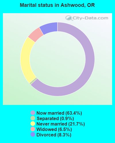
- Never married: 21.7%
- Now married: 63.4%
- Separated: 0.9%
- Widowed: 6.5%
- Divorced: 8.3%
For population 25 years and over in Ashwood:
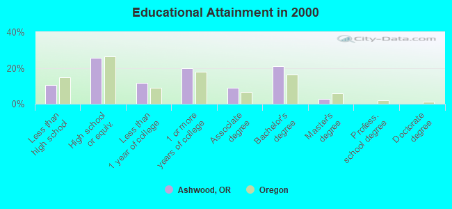
- High school or higher: 89.6%
- Bachelor's degree or higher: 23.6%
- Graduate or professional degree: 2.8%
- Unemployed: 4.0%
- Mean travel time to work (commute): 21.1 minutes
| Here: | 8.3 |
| Oregon average: | 11.5 |
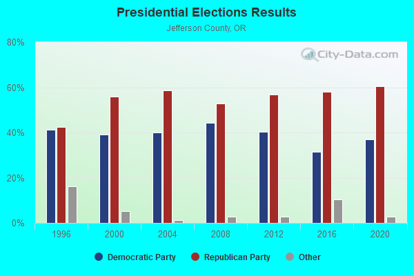
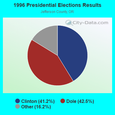
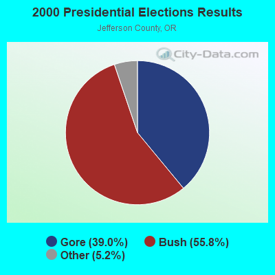


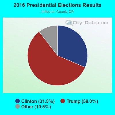
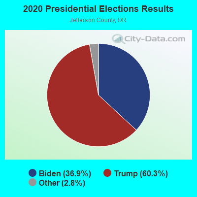
Graphs represent county-level data. Detailed 2008 Election Results
Religion statistics for Ashwood, OR (based on Jefferson County data)
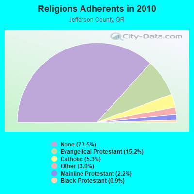
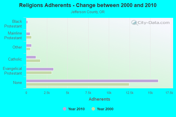
| Religion | Adherents | Congregations |
|---|---|---|
| Evangelical Protestant | 3,294 | 20 |
| Catholic | 1,156 | 2 |
| Other | 649 | 3 |
| Mainline Protestant | 477 | 4 |
| Black Protestant | 187 | 1 |
| None | 15,957 | - |
Food Environment Statistics:
| Jefferson County: | 3.39 / 10,000 pop. |
| Oregon: | 2.03 / 10,000 pop. |
| This county: | 0.48 / 10,000 pop. |
| State: | 0.33 / 10,000 pop. |
| Jefferson County: | 2.91 / 10,000 pop. |
| Oregon: | 2.01 / 10,000 pop. |
| Jefferson County: | 3.39 / 10,000 pop. |
| State: | 1.69 / 10,000 pop. |
| Here: | 6.79 / 10,000 pop. |
| State: | 9.93 / 10,000 pop. |
| This county: | 7.7% |
| Oregon: | 7.4% |
| Jefferson County: | 27.4% |
| Oregon: | 25.6% |
| This county: | 21.4% |
| State: | 14.2% |
Strongest AM radio stations in Ashwood:
- KBND (1110 AM; 12 kW; BEND, OR; Owner: COMBINED COMMUNICATIONS, INC.)
- KPOJ (620 AM; 50 kW; PORTLAND, OR; Owner: CITICASTERS LICENSES, L.P.)
- KXL (750 AM; 50 kW; PORTLAND, OR; Owner: ROSE CITY RADIO CORPORATION)
- KICE (940 AM; 10 kW; BEND, OR; Owner: GCC BEND, LLC)
- KPAM (860 AM; 50 kW; TROUTDALE, OR; Owner: PAMPLIN BROADCASTING-OREGON, INC.)
- KRCO (690 AM; 1 kW; PRINEVILLE, OR; Owner: HORIZON BROADCASTING GROUP LLC)
- KOTK (1080 AM; 50 kW; PORTLAND, OR; Owner: FISHER BROADCASTING - PORTLAND RADIO, L.L.C.)
- KEX (1190 AM; 50 kW; PORTLAND, OR; Owner: CITICASTERS LICENSES, L.P.)
- KPNW (1120 AM; 50 kW; EUGENE, OR; Owner: CAPSTAR TX LIMITED PARTNERSHIP)
- KKSN (1520 AM; 50 kW; OREGON CITY, OR; Owner: ENTERCOM PORTLAND LICENSE, LLC)
- KKAD (1550 AM; 50 kW; VANCOUVER, WA; Owner: PAMPLIN BROADCASTING-WASHINGTON, INC)
- KDUN (1030 AM; 50 kW; REEDSPORT, OR; Owner: PAMPLIN BROADCASTING-OREGON, INC.)
- KIRO (710 AM; 50 kW; SEATTLE, WA; Owner: ENTERCOM SEATTLE LICENSE, LLC)
Strongest FM radio stations in Ashwood:
- KWRX (88.5 FM; REDMOND, OR; Owner: ST BD OF HIGHER ED FOR THE UN OF OR)
- KWLZ-FM (96.5 FM; WARM SPRINGS, OR; Owner: HORIZON BROADCASTING GROUP LLC)
- KWSO (91.9 FM; WARM SPRINGS, OR; Owner: CONFEDERATED TRIBES WARM SPRINGS REV)
- KMJZ-FM (95.1 FM; PRINEVILLE, OR; Owner: HORIZON BROADCASTING GROUP LLC)
- KSJJ (102.9 FM; REDMOND, OR; Owner: GCC BEND, LLC)
- K266AI (101.1 FM; BEND, OR; Owner: CALVARY CHAPEL OF TWIN FALLS, INC.)
Ashwood fatal accident list:
FCC Registered Broadcast Land Mobile Towers:
1- ASHWOOD, 6.7 M South Of St Rd 218 & .4m East Of Cold Camp Rd (Lat: 44.819722 Lon: -120.652222), Type: Gtower, Structure height: 22 m, Call Sign: WQRV479,
Assigned Frequencies: 150.775 MHz, 153.815 MHz, 155.415 MHz, 153.905 MHz, 154.250 MHz, 155.865 MHz, 158.865 MHz, Grant Date: 05/27/2023, Expiration Date: 08/01/2033, Certifier: April Stream, Registrant: Federal Licensing Inc, 1588 Fairfield Road, Gettysburg, PA 17325, Phone: (717) 334-9262, Fax: (717) 334-6440, Email:
FCC Registered Microwave Towers:
1- ASHWOOD, 6.7m South Of St Rd 218 And 0.4m East Of Cold Camp Rd (Lat: 44.819722 Lon: -120.652222), Type: Mast, Structure height: 22 m, Call Sign: WQOR449,
Assigned Frequencies: 6226.89 MHz, 6389.96 MHz, 6197.24 MHz, 6197.24 MHz, 6226.89 MHz, 6197.24 MHz, 6226.89 MHz, 6197.24 MHz, 6226.89 MHz, 6197.24 MHz... (+74 more), Grant Date: 01/06/2012, Expiration Date: 01/06/2022, Cancellation Date: 05/14/2022, Certifier: Rob Myers, Registrant: Frontier Telenet, 401 Fourth St., Fossil, OR 97830, Phone: (541) 763-3460, Email:
FCC Registered Amateur Radio Licenses:
1- Call Sign: KG7USB, Licensee ID: L01953109, Grant Date: 06/24/2015, Expiration Date: 06/24/2025, Certifier: Amanda K Mckinnis, Registrant: Amanda K Mckinnis, 1103 Ne Trout Creek Road, Ashwood, OR 97711
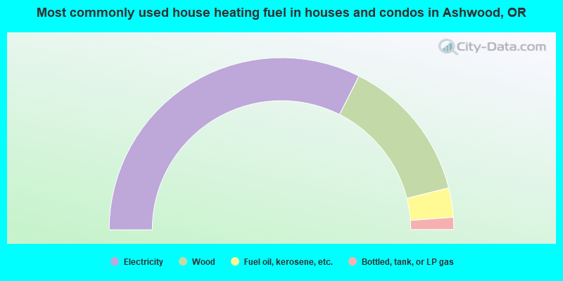
- 64.8%Electricity
- 27.3%Wood
- 5.5%Fuel oil, kerosene, etc.
- 2.3%Bottled, tank, or LP gas
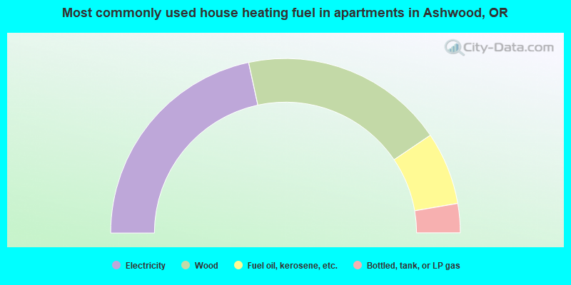
- 43.2%Electricity
- 37.8%Wood
- 13.5%Fuel oil, kerosene, etc.
- 5.4%Bottled, tank, or LP gas
Ashwood compared to Oregon state average:
- Unemployed percentage significantly below state average.
- Black race population percentage significantly below state average.
- Hispanic race population percentage below state average.
- Median age above state average.
- Foreign-born population percentage significantly below state average.
- Length of stay since moving in significantly above state average.
- Number of rooms per house significantly below state average.
- House age significantly below state average.
- Institutionalized population percentage significantly above state average.
- Number of college students significantly below state average.
Ashwood on our top lists:
- #40 on the list of "Top 100 cities with the largest percentage of males"