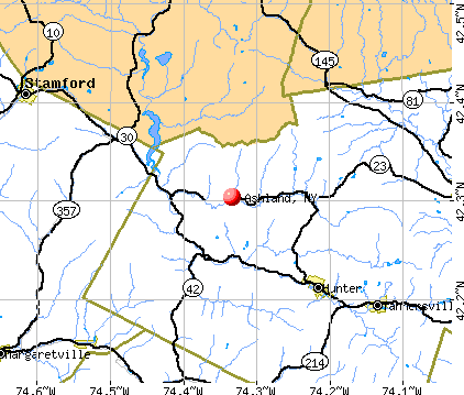
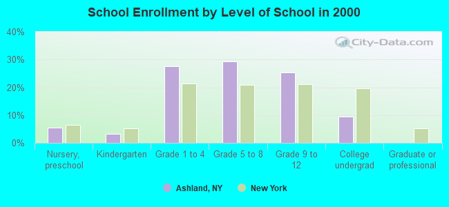
Ashland, New York
Submit your own pictures of this town and show them to the world
- OSM Map
- General Map
- Google Map
- MSN Map
Population change since 2000: -13.1%
 |
| Males: 843 | |
| Females: 852 |
| Median resident age: | 45.0 years |
| New York median age: | 40.7 years |
Zip codes: 14894.
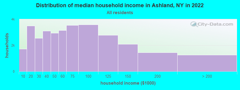
| Ashland: | $51,572 |
| NY: | $79,557 |
Estimated per capita income in 2022: $32,481 (it was $17,749 in 2000)
Ashland town income, earnings, and wages data
Estimated median house or condo value in 2022: $83,711 (it was $42,400 in 2000)
| Ashland: | $83,711 |
| NY: | $400,400 |
Mean prices in 2022: all housing units: $170,482; detached houses: $180,836; townhouses or other attached units: $173,487; in 2-unit structures: $137,786; in 3-to-4-unit structures: $79,646; in 5-or-more-unit structures: over $1,000,000; mobile homes: $54,295; occupied boats, rvs, vans, etc.: $68,256
Detailed information about poverty and poor residents in Ashland, NY


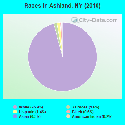
- 1,62595.9%White alone
- 271.6%Two or more races
- 241.4%Hispanic
- 100.6%Black alone
- 50.3%Asian alone
- 40.2%American Indian alone
Races in Ashland detailed stats: ancestries, foreign born residents, place of birth
 Recent articles from our blog. Our writers, many of them Ph.D. graduates or candidates, create easy-to-read articles on a wide variety of topics.


Latest news from Ashland, NY collected exclusively by city-data.com from local newspapers, TV, and radio stations
Ancestries: Irish (15.7%), German (15.3%), English (14.5%), United States (7.7%), Italian (5.9%), Polish (5.0%).
Current Local Time: EST time zone
Land area: 14.1 square miles.
Population density: 120 people per square mile (very low).
24 residents are foreign born
| This town: | 1.2% |
| New York: | 20.4% |
| Ashland town: | 3.7% ($1,589) |
| New York: | 1.9% ($2,847) |
Nearest city with pop. 50,000+: Union, NY (37.4 miles  , pop. 56,298).
Nearest city with pop. 200,000+: Rochester, NY (90.7 miles , pop. 219,773).
Nearest city with pop. 1,000,000+: Philadelphia, PA (162.9 miles , pop. 1,517,550).
Nearest cities:
), ), ), Latitude: 42.02 N, Longitude: 76.74 W
Area code commonly used in this area: 607

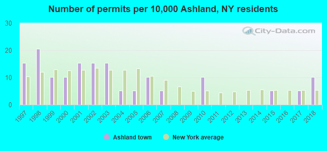
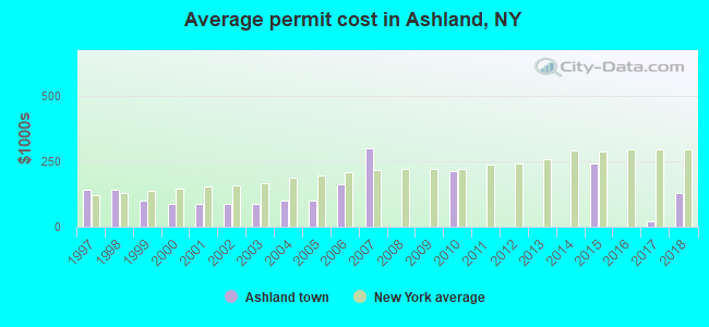
Single-family new house construction building permits:
- 2018: 2 buildings, average cost: $128,700
- 2017: 1 building, cost: $20,000
- 2015: 1 building, cost: $242,000
- 2010: 2 buildings, average cost: $212,500
- 2007: 1 building, cost: $300,000
- 2006: 2 buildings, average cost: $162,500
- 2005: 1 building, cost: $100,000
- 2004: 1 building, cost: $100,000
- 2003: 3 buildings, average cost: $87,500
- 2002: 3 buildings, average cost: $87,500
- 2001: 3 buildings, average cost: $87,500
- 2000: 2 buildings, average cost: $87,500
- 1999: 2 buildings, average cost: $100,000
- 1998: 4 buildings, average cost: $143,300
- 1997: 3 buildings, average cost: $143,300
| Here: | 4.5% |
| New York: | 4.4% |
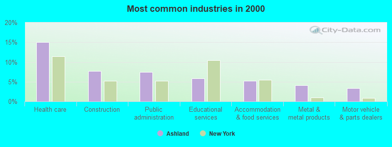
- Health care (15.1%)
- Construction (7.6%)
- Public administration (7.4%)
- Educational services (5.8%)
- Accommodation & food services (5.2%)
- Metal & metal products (4.1%)
- Motor vehicle & parts dealers (3.4%)
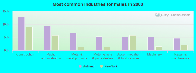
- Construction (12.8%)
- Public administration (9.4%)
- Metal & metal products (6.6%)
- Motor vehicle & parts dealers (5.3%)
- Accommodation & food services (5.1%)
- Machinery (5.1%)
- Repair & maintenance (4.7%)
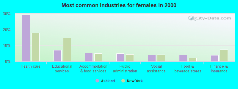
- Health care (29.3%)
- Educational services (7.1%)
- Accommodation & food services (5.3%)
- Public administration (5.1%)
- Social assistance (4.1%)
- Food & beverage stores (4.1%)
- Finance & insurance (3.8%)
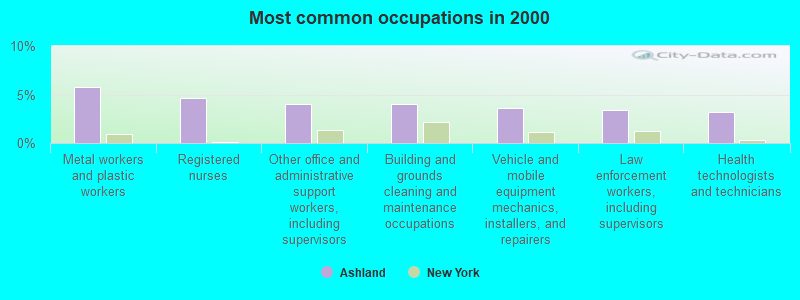
- Metal workers and plastic workers (5.8%)
- Registered nurses (4.6%)
- Other office and administrative support workers, including supervisors (4.1%)
- Building and grounds cleaning and maintenance occupations (4.1%)
- Vehicle and mobile equipment mechanics, installers, and repairers (3.6%)
- Law enforcement workers, including supervisors (3.4%)
- Health technologists and technicians (3.2%)
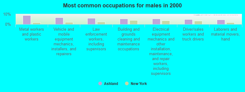
- Metal workers and plastic workers (8.9%)
- Vehicle and mobile equipment mechanics, installers, and repairers (6.6%)
- Law enforcement workers, including supervisors (6.2%)
- Building and grounds cleaning and maintenance occupations (5.5%)
- Electrical equipment mechanics and other installation, maintenance, and repair workers, including supervisors (5.3%)
- Driver/sales workers and truck drivers (4.9%)
- Laborers and material movers, hand (4.5%)
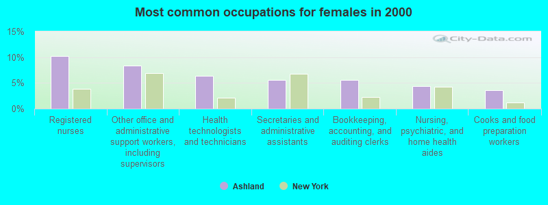
- Registered nurses (10.2%)
- Other office and administrative support workers, including supervisors (8.4%)
- Health technologists and technicians (6.4%)
- Secretaries and administrative assistants (5.6%)
- Bookkeeping, accounting, and auditing clerks (5.6%)
- Nursing, psychiatric, and home health aides (4.3%)
- Cooks and food preparation workers (3.6%)
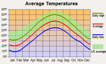
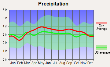
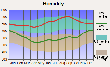
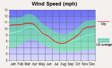
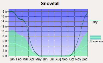
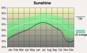
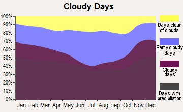
Average climate in Ashland, New York
Based on data reported by over 4,000 weather stations
(lower is better)
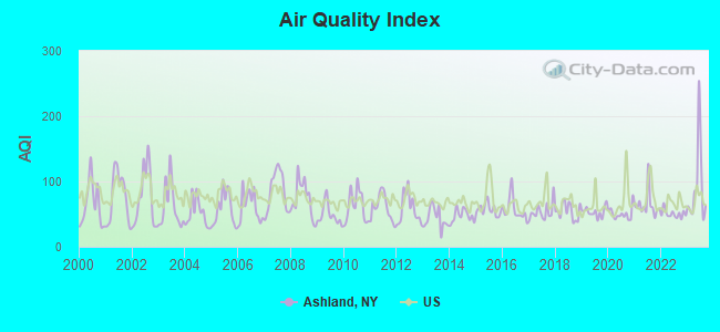
Air Quality Index (AQI) level in 2023 was 91.9. This is worse than average.
| City: | 91.9 |
| U.S.: | 72.6 |
Carbon Monoxide (CO) [ppm] level in 2023 was 0.156. This is significantly better than average. Closest monitor was 6.9 miles away from the city center.
| City: | 0.156 |
| U.S.: | 0.251 |
Nitrogen Dioxide (NO2) [ppb] level in 2011 was 2.25. This is significantly better than average. Closest monitor was 6.9 miles away from the city center.
| City: | 2.25 |
| U.S.: | 5.11 |
Sulfur Dioxide (SO2) [ppb] level in 2023 was 0.0309. This is significantly better than average. Closest monitor was 6.9 miles away from the city center.
| City: | 0.0309 |
| U.S.: | 1.5147 |
Ozone [ppb] level in 2023 was 35.9. This is about average. Closest monitor was 6.9 miles away from the city center.
| City: | 35.9 |
| U.S.: | 33.3 |
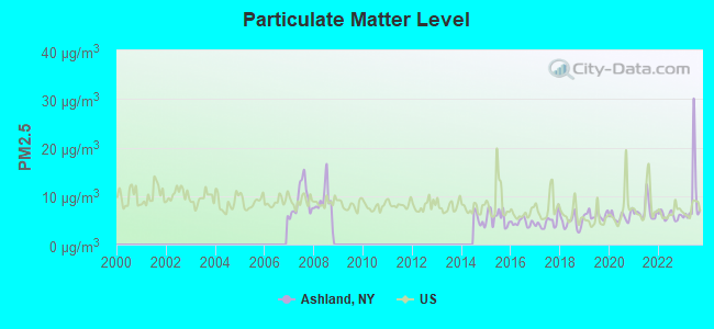
Particulate Matter (PM2.5) [µg/m3] level in 2023 was 9.50. This is about average. Closest monitor was 24.6 miles away from the city center.
| City: | 9.50 |
| U.S.: | 8.11 |
Tornado activity:
Ashland-area historical tornado activity is near New York state average. It is 59% smaller than the overall U.S. average.
On 5/2/1983, a category F3 (max. wind speeds 158-206 mph) tornado 3.1 miles away from the Ashland town center injured 6 people and caused between $500,000 and $5,000,000 in damages.
On 5/2/1983, a category F3 tornado 10.9 miles away from the town center injured one person and caused between $500,000 and $5,000,000 in damages.
Earthquake activity:
Ashland-area historical earthquake activity is significantly above New York state average. It is 66% smaller than the overall U.S. average.On 10/7/1983 at 10:18:46, a magnitude 5.3 (5.1 MB, 5.3 LG, 5.1 ML, Class: Moderate, Intensity: VI - VII) earthquake occurred 180.4 miles away from the city center
On 8/23/2011 at 17:51:04, a magnitude 5.8 (5.8 MW, Depth: 3.7 mi) earthquake occurred 291.4 miles away from the city center
On 9/25/1998 at 19:52:52, a magnitude 5.2 (4.8 MB, 4.3 MS, 5.2 LG, 4.5 MW, Depth: 3.1 mi) earthquake occurred 192.2 miles away from the city center
On 4/20/2002 at 10:50:47, a magnitude 5.3 (5.3 ML, Depth: 3.0 mi) earthquake occurred 230.5 miles away from Ashland center
On 4/20/2002 at 10:50:47, a magnitude 5.2 (5.2 MB, 4.2 MS, 5.2 MW, 5.0 MW) earthquake occurred 228.5 miles away from Ashland center
On 1/16/1994 at 01:49:16, a magnitude 4.6 (4.6 MB, 4.6 LG, Depth: 3.1 mi, Class: Light, Intensity: IV - V) earthquake occurred 122.6 miles away from Ashland center
Magnitude types: regional Lg-wave magnitude (LG), body-wave magnitude (MB), local magnitude (ML), surface-wave magnitude (MS), moment magnitude (MW)
Natural disasters:
The number of natural disasters in Chemung County (16) is near the US average (15).Major Disasters (Presidential) Declared: 9
Emergencies Declared: 6
Causes of natural disasters: Floods: 6, Storms: 6, Tropical Storms: 3, Hurricanes: 2, Tornadoes: 2, Blizzard: 1, Flash Flood: 1, Heavy Rain: 1, Landslide: 1, Power Outage: 1, Wind: 1, Other: 2 (Note: some incidents may be assigned to more than one category).
Hospitals and medical centers near Ashland:
- CHEMUNG COUNTY CHAPTER NYS ARC, INC (Hospital, about 5 miles away; ELMIRA, NY)
- CHEMUNG CO DEPT HEALTH CHHA (Home Health Center, about 6 miles away; ELMIRA, NY)
- CHEMUNG COUNTY HEALTH CENTER (Nursing Home, about 6 miles away; ELMIRA, NY)
- ARNOT ODGEN MEDICAL CENTER 2C UNIT (Dialysis Facility, about 7 miles away; ELMIRA, NY)
- ARNOT OGDEN MEDICAL CENTER Acute Care Hospitals (about 7 miles away; ELMIRA, NY)
- UCPA OF CHEMUNG COUNTY (Hospital, about 8 miles away; ELMIRA HEIGHTS, NY)
- CHEMUNG COUNTY CHAPTER NYS ARC, INC (Hospital, about 9 miles away; ELMIRA, NY)
Colleges/universities with over 2000 students nearest to Ashland:
- Corning Community College (about 19 miles; Corning, NY; Full-time enrollment: 3,036)
- Mansfield University of Pennsylvania (about 24 miles; Mansfield, PA; FT enrollment: 2,826)
- Ithaca College (about 31 miles; Ithaca, NY; FT enrollment: 6,781)
- Cornell University (about 33 miles; Ithaca, NY; FT enrollment: 20,360)
- SUNY at Binghamton (about 40 miles; Vestal, NY; FT enrollment: 15,096)
- Tompkins Cortland Community College (about 41 miles; Dryden, NY; FT enrollment: 3,884)
- SUNY Broome Community College (about 44 miles; Binghamton, NY; FT enrollment: 4,969)
Points of interest:
Notable location: Grace Farms (A). Display/hide its location on the map
Churches in Ashland include: South Creek Evangelical Church (A), Wellsburg United Methodist Church (B). Display/hide their locations on the map
Cemeteries: Roushy Cemetery (1), Miller Cemetery (2), Scudder Cemetery (3), Elliott-Searles Cemetery (4), Ashland Cemetery (5), Wellsburg Baptist Church Cemetery (6). Display/hide their locations on the map
Creeks: Baldwin Creek (A), Coldbrook Creek (B), Bentley Creek (C). Display/hide their locations on the map
Birthplace of: George Sanford (American football) - Football player and coach, Jerry Lane - Baseball player.
Drinking water stations with addresses in Ashland and their reported violations in the past:
MOHAWK CAMPGROUND (Address: 12297 Route 23 , Population served: 200, Groundwater):Past monitoring violations:
- 2 routine major monitoring violations
- One regular monitoring violation
| This town: | 2.4 people |
| New York: | 2.6 people |
| This town: | 65.2% |
| Whole state: | 63.5% |
| This town: | 10.2% |
| Whole state: | 6.8% |
Likely homosexual households (counted as self-reported same-sex unmarried-partner households)
- Lesbian couples: 0.6% of all households
- Gay men: 0.3% of all households
| This town: | 11.2% |
| Whole state: | 14.6% |
| This town: | 3.6% |
| Whole state: | 7.4% |
8 people in group homes intended for adults in 2010
8 people in homes for the mentally retarded in 2000
For population 15 years and over in Ashland:
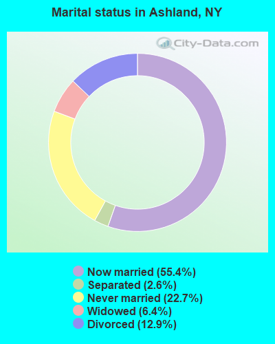
- Never married: 22.7%
- Now married: 55.4%
- Separated: 2.6%
- Widowed: 6.4%
- Divorced: 12.9%
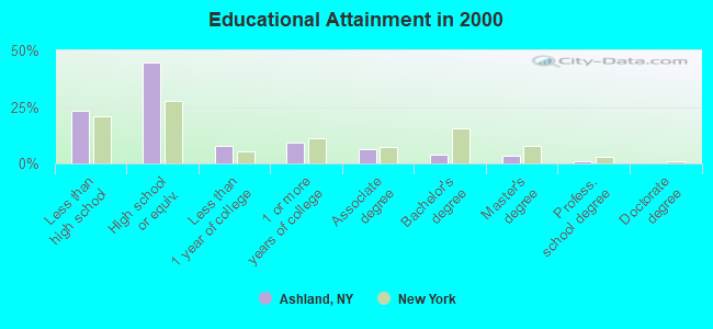
For population 25 years and over in Ashland:
- High school or higher: 76.8%
- Bachelor's degree or higher: 8.6%
- Graduate or professional degree: 4.5%
- Unemployed: 6.9%
- Mean travel time to work (commute): 22.2 minutes
| Here: | 10.2 |
| New York average: | 14.2 |
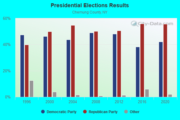
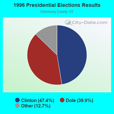
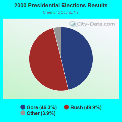
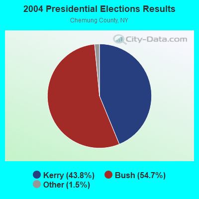
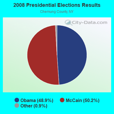
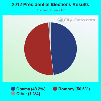
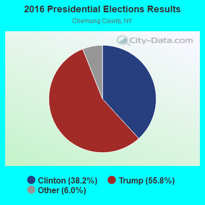
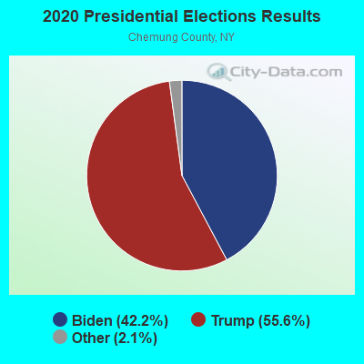
Graphs represent county-level data. Detailed 2008 Election Results
Religion statistics for Ashland, NY (based on Chemung County data)
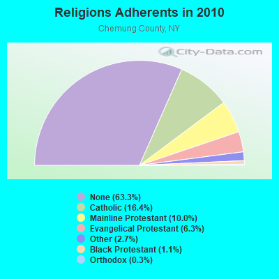
| Religion | Adherents | Congregations |
|---|---|---|
| Catholic | 14,593 | 5 |
| Mainline Protestant | 8,842 | 46 |
| Evangelical Protestant | 5,604 | 46 |
| Other | 2,399 | 8 |
| Black Protestant | 965 | 3 |
| Orthodox | 230 | 2 |
| None | 56,197 | - |
Food Environment Statistics:
| Here: | 1.36 / 10,000 pop. |
| New York: | 4.13 / 10,000 pop. |
| Here: | 0.11 / 10,000 pop. |
| New York: | 0.06 / 10,000 pop. |
| Here: | 1.59 / 10,000 pop. |
| New York: | 0.92 / 10,000 pop. |
| Chemung County: | 3.30 / 10,000 pop. |
| New York: | 1.68 / 10,000 pop. |
| Chemung County: | 7.62 / 10,000 pop. |
| New York: | 8.82 / 10,000 pop. |
| This county: | 9.1% |
| State: | 8.2% |
| Chemung County: | 27.0% |
| State: | 23.8% |
| Chemung County: | 13.2% |
| New York: | 15.6% |
Strongest AM radio stations in Ashland:
- WELM (1410 AM; 5 kW; ELMIRA, NY; Owner: PEMBROOK PINES ELMIRA, LIMITED)
- WENY (1230 AM; 1 kW; ELMIRA, NY; Owner: EOLIN BROADCASTING, INC.)
- WLNL (1000 AM; daytime; 5 kW; HORSEHEADS, NY; Owner: LIGHTHOUSE MEDIA, INC.)
- WWLZ (820 AM; 4 kW; HORSEHEADS, NY; Owner: CHEMUNG COUNTY RADIO, INC.)
- WEHH (1590 AM; 5 kW; ELMIRA HTS/HORSEHEAD, NY; Owner: PEMBROOK PINES ELMIRA, LTD.)
- WATS (960 AM; 5 kW; SAYRE, PA; Owner: WATS BROADCASTING, INC.)
- WEBO (1330 AM; 5 kW; OWEGO, NY; Owner: TIOGA MEDIA, INC.)
- WABH (1380 AM; 10 kW; BATH, NY)
- WHAM (1180 AM; 50 kW; ROCHESTER, NY; Owner: CITICASTERS LICENSES, L.P.)
- WNBF (1290 AM; 9 kW; BINGHAMTON, NY; Owner: CITADEL BROADCASTING COMPANY)
- WHCU (870 AM; 5 kW; ITHACA, NY; Owner: EAGLE BROADCASTING COMPANY, INC.)
- WTKO (1470 AM; 5 kW; ITHACA, NY; Owner: EAGLE II BROADCASTING CORPORATION)
- WWJZ (640 AM; 50 kW; MOUNT HOLLY, NJ; Owner: ABC, INC.)
Strongest FM radio stations in Ashland:
- WENY-FM (92.7 FM; ELMIRA, NY; Owner: EOLIN BROADCASTING, INC.)
- W201CO (88.1 FM; ELMIRA, NY; Owner: FAMILY LIFE MINISTRIES, INC.)
- WLVY (94.3 FM; ELMIRA, NY; Owner: PEMBROOK PINES ELMIRA, LTD.)
- WOKN (99.5 FM; SOUTHPORT, NY; Owner: PEMBROOK PINES ELMIRA, LTD.)
- W205BR (88.9 FM; ELMIRA, NY; Owner: PENSACOLA CHRISTIAN COLLEGE, INC.)
- WSQE (91.1 FM; CORNING, NY; Owner: WSKG PUB. TELECOMMUNICATIONS COUNCIL)
- WREQ (96.9 FM; RIDGEBURY, PA; Owner: CSN INTERNATIONAL)
- WMTT (94.7 FM; TIOGA, PA; Owner: EUROPA COMMUNICATIONS, INC.)
- WCIH (90.3 FM; ELMIRA, NY; Owner: FAMILY LIFE MINISTRIES, INC.)
- WHGL-FM (100.3 FM; CANTON, PA; Owner: CANTROAIR COMMUNICATIONS INC.)
- WAVR (102.3 FM; WAVERLY, NY; Owner: WATS BROADCASTING, INC.)
- WCBA-FM (98.7 FM; CORNING, NY; Owner: EOLIN BROADCASTING, INC.)
- WGMM (97.7 FM; BIG FLATS, NY; Owner: EOLIN BROADCASTING, INC.)
- WQNY (103.7 FM; ITHACA, NY; Owner: EAGLE II BROADCASTING CORPORATION)
- WNBQ (92.3 FM; MANSFIELD, PA; Owner: FARM & HOME BROADCASTING COMPANY)
- WNKI (106.1 FM; CORNING, NY; Owner: CHEMUNG COUNTY RADIO, INC.)
- WNGZ (104.9 FM; MONTOUR FALLS, NY; Owner: CHEMUNG COUNTY RADIO, INC.)
- W238AI (95.5 FM; ELMIRA, NY; Owner: EUROPA COMMUNICATIONS, INC.)
- WHWK (98.1 FM; BINGHAMTON, NY; Owner: CITADEL BROADCASTING COMPANY)
- WCII (88.5 FM; SPENCER, NY; Owner: FAMILY LIFE MINISTRIES, INC.)
TV broadcast stations around Ashland:
- W59DG (Channel 59; ELMIRA, NY; Owner: TRINITY BROADCASTING NETWORK)
- WETM-TV (Channel 18; ELMIRA, NY; Owner: SMITH TELEVISION OF NEW YORK LICENSE HOLDINGS, INC.)
- WENY-TV (Channel 36; ELMIRA, NY; Owner: LILLY BROADCASTING, L.L.C.)
- W21BW (Channel 21; ELMIRA, NY; Owner: THREE ANGELS BROADCASTING NETWORK INC.)
- W52CE (Channel 52; SAYRE, PA; Owner: WOLF LICENSE CORP.)
- WYDC (Channel 48; CORNING, NY; Owner: WYDC, INC.)
- W26BF (Channel 26; ELMIRA, NY; Owner: WYDC, INC.)
- WSKG-TV (Channel 46; BINGHAMTON, NY; Owner: WSKG PUBLIC TELECOMMUNICATIONS COUNCIL)
- WICZ-TV (Channel 40; BINGHAMTON, NY; Owner: STAINLESS BROADCASTING, L.P.)
- National Bridge Inventory (NBI) Statistics
- 6Number of bridges
- 92ft / 28.4mTotal length
- $14,562,000Total costs
- 29,825Total average daily traffic
- 868Total average daily truck traffic
FCC Registered Cell Phone Towers:
2 (See the full list of FCC Registered Cell Phone Towers in Ashland)FCC Registered Antenna Towers:
20 (See the full list of FCC Registered Antenna Towers)FCC Registered Private Land Mobile Towers:
1- Comfort Hill (Lat: 42.032028 Lon: -76.783278), Structure height: 91 m, Call Sign: WPFM320,
Assigned Frequencies: 929.512 MHz, Grant Date: 07/28/1999, Expiration Date: 07/28/2009, Cancellation Date: 11/08/2004, Certifier: Kenneth Goldstein, Registrant: Alston & Bird LLP, 601 Pennsylvania Ave., Nw, North Building, 10th Floor, Washington, DC 20004, Phone: (202) 756-3376, Fax: (202) 756-3333, Email:
FCC Registered Broadcast Land Mobile Towers:
1- Comfort Hill Rd (Lat: 42.032583 Lon: -76.780500), Call Sign: KLB447, Licensee ID: L00438967,
Assigned Frequencies: 43.8800 MHz, Grant Date: 02/01/2002, Expiration Date: 03/16/2012, Cancellation Date: 05/19/2012, Registrant: G & T Air Expediting Service Inc, 1100 Sullivan St, Elmira, NY 14902
FCC Registered Microwave Towers:
5- Comfort Hill Rd (Lat: 42.032000 Lon: -76.783556), Overall height: 36.6 m, Call Sign: WPOP944,
Assigned Frequencies: 950.375 MHz, 950.625 MHz, Grant Date: 09/08/1998, Expiration Date: 08/01/2014, Cancellation Date: 07/06/2009, Phone: (814) 371-1330
- Comfort Hill, Comfort Hill Road (Lat: 42.032250 Lon: -76.783611), Type: Mast, Structure height: 56.4 m, Overall height: 60 m, Call Sign: WPYX364, Licensee ID: L00044605,
Assigned Frequencies: 945.000 MHz, Grant Date: 11/20/2003, Expiration Date: 06/01/2030, Certifier: Robert Eolin, Registrant: Southern Belle, LLC
- COMFORT HILL, Comfort Hill Road (Lat: 42.032250 Lon: -76.783611), Type: Mast, Structure height: 56.4 m, Overall height: 60 m, Call Sign: WQUI250,
Assigned Frequencies: 10875.0 MHz, Grant Date: 07/15/2014, Expiration Date: 07/15/2024, Cancellation Date: 10/25/2023, Certifier: Chris Harris, Registrant: Conterra Ultra Broadband, LLC, 5301 77 Center Drive, Charlotte, NC 28217, Phone: (704) 936-1777, Fax: (704) 936-1801, Email:
- ELMIRA, Maple Street (Lat: 42.040611 Lon: -76.776611), Overall height: 82.3 m, Call Sign: WHO327, Licensee ID: L00129200,
Assigned Frequencies: 5945.20 MHz, 5974.85 MHz, 5945.20 MHz, 6034.15 MHz, 5974.85 MHz, 6004.50 MHz, 6063.80 MHz, 6063.80 MHz, 6093.45 MHz, 6034.15 MHz... (+6 more), Grant Date: 02/27/2001, Expiration Date: 02/01/2011, Cancellation Date: 09/07/2007, Certifier: Michael J Shortley Iii, Registrant: Global Crossing North American Networks, Inc.
- COMFORT HILL, Comfort Hill Road (Lat: 42.032250 Lon: -76.783611), Type: Mast, Structure height: 56.4 m, Overall height: 60 m, Call Sign: WLT281,
Assigned Frequencies: 6004.50 MHz, 6063.80 MHz, 6034.15 MHz, 5974.85 MHz, Grant Date: 02/15/2011, Expiration Date: 02/01/2021, Cancellation Date: 06/30/2015, Registrant: Verizon Wireless, 1120 Sanctuary Pkwy, #150 Gasa5reg, Alpharetta, GA 30009-7630, Phone: (770) 797-1070, Fax: (770) 797-1036, Email:
FCC Registered Amateur Radio Licenses:
1- Call Sign: KC2FRV, Licensee ID: L00179671, Grant Date: 12/02/1999, Expiration Date: 12/02/2009, Cancellation Date: 12/03/2011, Certifier: Thomas P Dignam, Registrant: Thomas P Dignam, Ashland, NY 12407
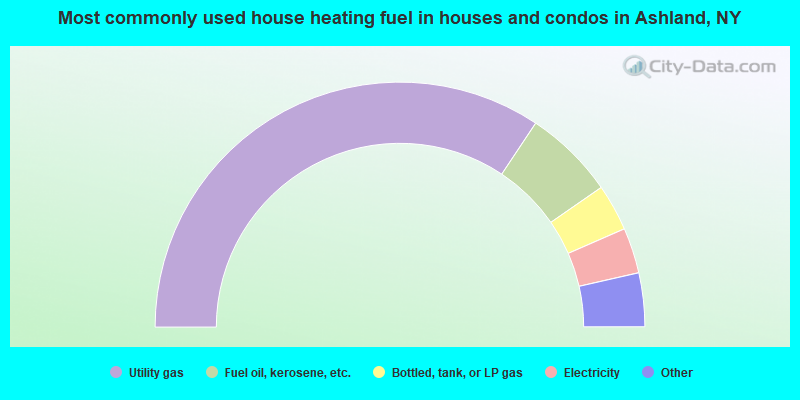
- 68.7%Utility gas
- 12.0%Fuel oil, kerosene, etc.
- 6.2%Bottled, tank, or LP gas
- 6.0%Electricity
- 3.8%Wood
- 2.6%Coal or coke
- 0.8%Other fuel
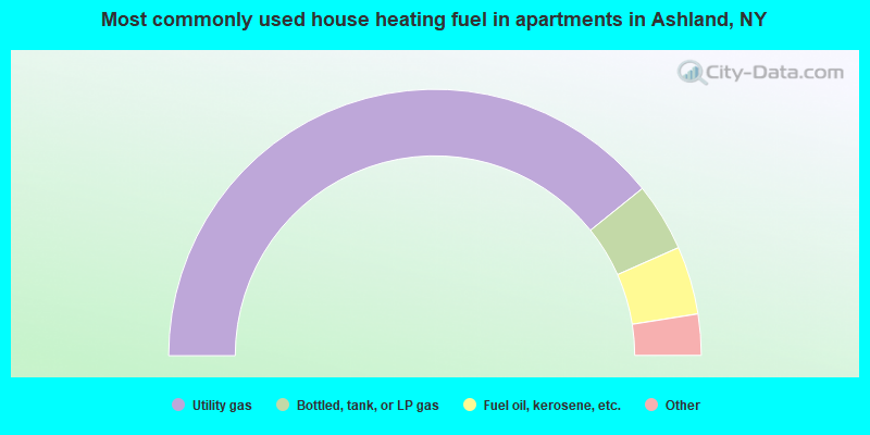
- 78.5%Utility gas
- 8.3%Bottled, tank, or LP gas
- 8.3%Fuel oil, kerosene, etc.
- 3.3%Electricity
- 1.7%Wood
Ashland compared to New York state average:
- Median household income below state average.
- Median house value significantly below state average.
- Unemployed percentage below state average.
- Black race population percentage significantly below state average.
- Hispanic race population percentage significantly below state average.
- Median age above state average.
- Foreign-born population percentage significantly below state average.
- Renting percentage significantly below state average.
- Length of stay since moving in significantly above state average.
- Number of rooms per house significantly below state average.
- House age significantly below state average.
- Number of college students below state average.
- Percentage of population with a bachelor's degree or higher significantly below state average.