Ashby, Massachusetts
Submit your own pictures of this town and show them to the world
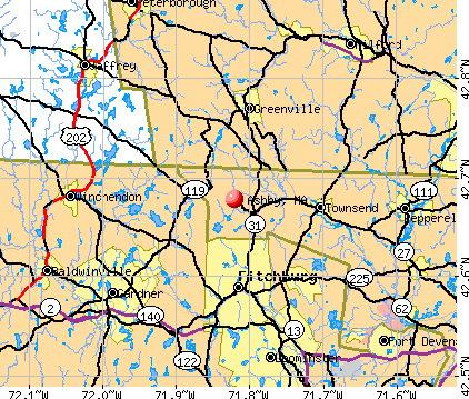
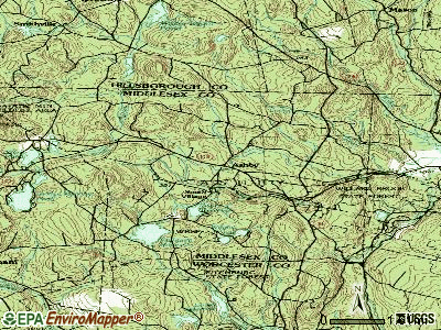
- OSM Map
- General Map
- Google Map
- MSN Map
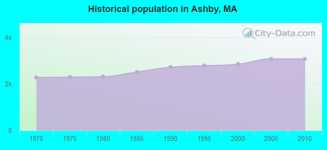
Population change since 2000: +8.0%
 |
| Males: 1,545 | |
| Females: 1,529 |
| Median resident age: | 42.6 years |
| Massachusetts median age: | 39.2 years |
Zip codes: 01431.
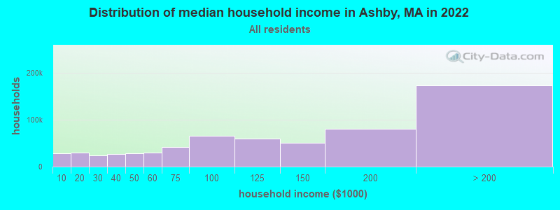
| Ashby: | $119,150 |
| MA: | $94,488 |
Estimated per capita income in 2022: $44,945 (it was $21,648 in 2000)
Ashby town income, earnings, and wages data
Estimated median house or condo value in 2022: $416,911 (it was $147,500 in 2000)
| Ashby: | $416,911 |
| MA: | $534,700 |
Mean prices in 2022: all housing units: $796,617; detached houses: $834,667; townhouses or other attached units: $772,440; in 2-unit structures: $786,250; in 3-to-4-unit structures: $655,835; in 5-or-more-unit structures: $590,321; mobile homes: $144,935
Detailed information about poverty and poor residents in Ashby, MA
Compare current foreclosures near Ashby, MA:
| Photo | Address | Area | Beds / Baths | Price | Details |
|---|---|---|---|---|---|

|
#1
West Rd
Ashby, MA 01431
|
7,000 sq. feet
|
3 baths 10 beds |
show details | |

|
#2
Kendall Hill Rd
Ashby, MA 01431
|
2,852 sq. feet
|
2 baths 4 beds |
show details | |

|
#3
Turnpike Rd
Ashby, MA 01431
|
960 sq. feet
|
1 baths 2 beds |
show details | |

|
#4
Laurelwood Dr
Ashby, MA 01431
|
5,235 sq. feet
|
4 baths 4 beds |
show details | |

|
#5
Deer Bay Rd
Ashby, MA 01431
|
- sq. feet
|
- baths - beds |
show details | |

|
#6
Jones Hill Rd
Ashby, MA 01431
|
- sq. feet
|
- baths - beds |
show details | |

|
#7
Great Rd
Shirley, MA 01464
|
1,672 sq. feet
|
1 baths 2 beds |
$464,900
|
show details |

|
#8
Graham St
Leominster, MA 01453
|
1,036 sq. feet
|
1 baths 3 beds |
$485,000
|
show details |

|
#9
Pearl Hill Rd
Fitchburg, MA 01420
|
2,152 sq. feet
|
2 baths 3 beds |
$529,900
|
show details |

|
#10
Parker St
Gardner, MA 01440
|
1,980 sq. feet
|
2 baths 4 beds |
$469,900
|
show details |
| Photo | Address | Area | Beds / Baths | Price | Details |
|---|---|---|---|---|---|

|
#11
Sylvan Ave
Leominster, MA 01453
|
720 sq. feet
|
1 baths 2 beds |
$375,000
|
show details |

|
#12
Iriquois Dr
Ashburnham, MA 01430
|
2,016 sq. feet
|
2 baths 3 beds |
$369,000
|
show details |

|
#13
Hemlock Dr
Lunenburg, MA 01462
|
696 sq. feet
|
1 baths 2 beds |
show details | |

|
#14
Reagan Rd
Townsend, MA 01469
|
1,591 sq. feet
|
2 baths 3 beds |
show details | |

|
#15
Clyde St
Fitchburg, MA 01420
|
2,028 sq. feet
|
3 baths 5 beds |
show details | |

|
#16
Priest St
Leominster, MA 01453
|
1,016 sq. feet
|
1 baths 3 beds |
show details | |

|
#17
Grove Ave
Leominster, MA 01453
|
3,097 sq. feet
|
1 baths 4 beds |
show details | |

|
#18
Juniper Dr
Amherst, NH 03031
|
3,364 sq. feet
|
4 baths 4 beds |
show details | |

|
#19
Mallard Drive, Unit 59 Coggshall Crossing Condominium
Fitchburg, MA 01420
|
1,306 sq. feet
|
1 baths 2 beds |
show details | |

|
#20
Ashburnham St
Fitchburg, MA 01420
|
2,095 sq. feet
|
1 baths 4 beds |
show details |
| Photo | Address | Area | Beds / Baths | Price | Details |
|---|---|---|---|---|---|

|
#21
Amherst St
Amherst, NH 03031
|
- sq. feet
|
4 baths 3 beds |
show details | |

|
#22
Fitzgerald Rd
Rindge, NH 03461
|
3,960 sq. feet
|
3 baths 4 beds |
show details | |

|
#23
Leo Dr
Gardner, MA 01440
|
1,206 sq. feet
|
1 baths 3 beds |
show details | |

|
#24
Malburn St
Leominster, MA 01453
|
1,008 sq. feet
|
1 baths 3 beds |
show details | |

|
#25
Juniper St
Winchendon, MA 01475
|
1,687 sq. feet
|
1 baths 4 beds |
show details | |

|
#26
Chelsea St
Gardner, MA 01440
|
1,498 sq. feet
|
1 baths 3 beds |
show details | |

|
#27
West St
Gardner, MA 01440
|
1,320 sq. feet
|
2 baths 3 beds |
show details | |

|
#28
Mill St
Gardner, MA 01440
|
1,728 sq. feet
|
1 baths 4 beds |
show details | |

|
#29
Hill St
Leominster, MA 01453
|
1,680 sq. feet
|
2 baths 5 beds |
show details | |

|
#30
Emerald St
Gardner, MA 01440
|
1,428 sq. feet
|
1 baths 2 beds |
show details |
| Photo | Address | Area | Beds / Baths | Price | Details |
|---|---|---|---|---|---|

|
#31
Travers St
Gardner, MA 01440
|
660 sq. feet
|
1 baths 1 beds |
show details | |

|
#32
Pelley St
Gardner, MA 01440
|
1,011 sq. feet
|
2 baths 3 beds |
show details | |

|
#33
Emerald St
Gardner, MA 01440
|
1,428 sq. feet
|
1 baths 2 beds |
show details | |

|
#34
Cortland Cir # 41
Leominster, MA 01453
|
1,038 sq. feet
|
1 baths 2 beds |
show details | |

|
#35
Hollis St
Pepperell, MA 01463
|
1,242 sq. feet
|
1 baths 3 beds |
show details | |

|
#36
Greenwood Pl
Gardner, MA 01440
|
1,206 sq. feet
|
1 baths 2 beds |
show details | |

|
#37
Maple St
Winchendon, MA 01475
|
903 sq. feet
|
1 baths 2 beds |
show details | |

|
#38
Lorchris St
Leominster, MA 01453
|
972 sq. feet
|
1 baths 2 beds |
show details | |

|
#39
Teel Rd
Winchendon, MA 01475
|
1,080 sq. feet
|
1 baths 3 beds |
show details | |

|
#40
Prospect St
Leominster, MA 01453
|
4,884 sq. feet
|
2 baths 4 beds |
show details |
| Photo | Address | Area | Beds / Baths | Price | Details |
|---|---|---|---|---|---|

|
#41
Countryside Rd
Pepperell, MA 01463
|
1,344 sq. feet
|
1 baths 3 beds |
show details | |

|
#42
Old New Ipswich Rd
Rindge, NH 03461
|
1,184 sq. feet
|
2 baths 3 beds |
show details | |

|
#43
Union St
Leominster, MA 01453
|
2,958 sq. feet
|
6 baths 9 beds |
show details | |

|
#44
Maple St
Winchendon, MA 01475
|
1,000 sq. feet
|
1 baths 2 beds |
show details | |

|
#45
Carter Rd
Westminster, MA 01473
|
2,182 sq. feet
|
1 baths 3 beds |
show details | |

|
#46
Middle St
Leominster, MA 01453
|
1,170 sq. feet
|
2 baths 3 beds |
show details | |

|
#47
Cheyenne Rd
Pepperell, MA 01463
|
1,728 sq. feet
|
2 baths 4 beds |
show details | |

|
#48
Green St
Gardner, MA 01440
|
3,156 sq. feet
|
2 baths 4 beds |
show details | |

|
#49
Middle St
Leominster, MA 01453
|
945 sq. feet
|
1 baths 3 beds |
show details | |

|
Check over 1 million property listings on Foreclosure.com!
|
browse all offers | |||

- 2,95496.1%White alone
- 571.9%Hispanic
- 391.3%Two or more races
- 90.3%Black alone
- 100.3%Asian alone
- 20.07%American Indian alone
- 20.07%Other race alone
- 10.03%Native Hawaiian and Other
Pacific Islander alone
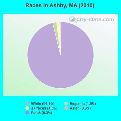
Races in Ashby detailed stats: ancestries, foreign born residents, place of birth
Type |
2009 |
2010 |
2011 |
2012 |
2013 |
2014 |
2018 |
2019 |
2020 |
2021 |
2022 |
|---|---|---|---|---|---|---|---|---|---|---|---|
| Murders (per 100,000) | 0 (0.0) | 0 (0.0) | 0 (0.0) | 0 (0.0) | 0 (0.0) | 0 (0.0) | 0 (0.0) | 0 (0.0) | 0 (0.0) | 0 (0.0) | 0 (0.0) |
| Rapes (per 100,000) | 0 (0.0) | 1 (32.5) | 0 (0.0) | 0 (0.0) | 1 (31.6) | 0 (0.0) | 1 (30.8) | 1 (31.0) | 2 (62.2) | 3 (92.5) | 1 (31.6) |
| Robberies (per 100,000) | 0 (0.0) | 0 (0.0) | 1 (32.3) | 0 (0.0) | 1 (31.6) | 0 (0.0) | 0 (0.0) | 0 (0.0) | 0 (0.0) | 0 (0.0) | 2 (63.2) |
| Assaults (per 100,000) | 0 (0.0) | 4 (130.1) | 3 (97.0) | 2 (63.8) | 5 (157.8) | 0 (0.0) | 1 (30.8) | 0 (0.0) | 2 (62.2) | 2 (61.7) | 0 (0.0) |
| Burglaries (per 100,000) | 16 (533.5) | 16 (520.5) | 20 (646.6) | 23 (733.9) | 23 (725.8) | 3 (94.0) | 2 (61.7) | 4 (123.9) | 4 (124.3) | 4 (123.4) | 5 (157.9) |
| Thefts (per 100,000) | 2 (66.7) | 0 (0.0) | 2 (64.7) | 9 (287.2) | 18 (568.0) | 1 (31.3) | 2 (61.7) | 4 (123.9) | 15 (466.3) | 15 (462.7) | 12 (379.0) |
| Auto thefts (per 100,000) | 2 (66.7) | 0 (0.0) | 2 (64.7) | 1 (31.9) | 2 (63.1) | 0 (0.0) | 2 (61.7) | 0 (0.0) | 2 (62.2) | 1 (30.8) | 0 (0.0) |
| Arson (per 100,000) | 0 (0.0) | 0 (0.0) | 0 (0.0) | 0 (0.0) | 0 (0.0) | 0 (0.0) | 0 (0.0) | 0 (0.0) | 0 (0.0) | 0 (0.0) | 0 (0.0) |
| City-Data.com crime index | 45.3 | 88.5 | 82.1 | 78.2 | 144.8 | 7.8 | 42.6 | 38.4 | 94.5 | 116.0 | 70.4 |
The City-Data.com crime index weighs serious crimes and violent crimes more heavily. Higher means more crime, U.S. average is 246.1. It adjusts for the number of visitors and daily workers commuting into cities.
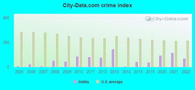
Crime rate in Ashby detailed stats: murders, rapes, robberies, assaults, burglaries, thefts, arson
Full-time law enforcement employees in 2021, including police officers: 7 (6 officers - 6 male; 0 female).
| Officers per 1,000 residents here: | 1.85 |
| Massachusetts average: | 2.53 |
 Recent articles from our blog. Our writers, many of them Ph.D. graduates or candidates, create easy-to-read articles on a wide variety of topics.

 | Home Prices By Town for 2022 (190 replies) |
| Seeking nature-oriented town with urban edge (99 replies) |
| Top 5 / Bottom 5 Cities / Towns in Middlesex County (15 replies) |
| Towns in Boston MSA, but many might think not (44 replies) |
| Relocating from Texas for child with autism (54 replies) |
| Biggest population gain during COVID: Plymouth!? check how your town did (26 replies) |
Latest news from Ashby, MA collected exclusively by city-data.com from local newspapers, TV, and radio stations
Ancestries: French (17.4%), English (17.3%), Irish (17.3%), French Canadian (8.5%), German (7.8%), Italian (7.1%).
Current Local Time: EST time zone
Incorporated in 1767
Elevation: 904 feet
Land area: 23.8 square miles.
Population density: 129 people per square mile (very low).
77 residents are foreign born (1.5% Europe, 1.1% North America).
| This town: | 2.7% |
| Massachusetts: | 12.2% |
| Ashby town: | 1.5% ($2,249) |
| Massachusetts: | 1.3% ($2,336) |
Nearest city with pop. 50,000+: Nashua, NH  (17.8 miles , pop. 86,605).
Nearest city with pop. 200,000+: Boston, MA (44.2 miles , pop. 589,141).
Nearest city with pop. 1,000,000+: Bronx, NY (165.0 miles , pop. 1,332,650).
Nearest cities:
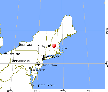
), )Latitude: 42.67 N, Longitude: 71.81 W
Area code: 978

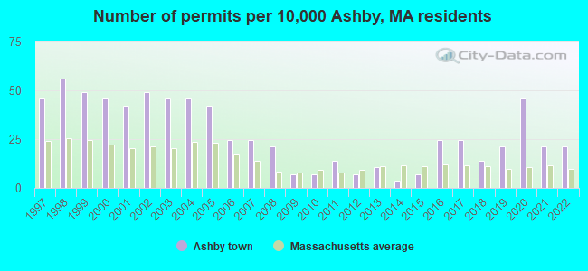
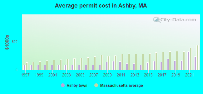
Single-family new house construction building permits:
- 2022: 6 buildings, average cost: $236,700
- 2021: 6 buildings, average cost: $323,600
- 2020: 13 buildings, average cost: $167,600
- 2019: 6 buildings, average cost: $167,500
- 2018: 4 buildings, average cost: $198,200
- 2017: 7 buildings, average cost: $144,600
- 2016: 7 buildings, average cost: $157,100
- 2015: 2 buildings, average cost: $135,000
- 2014: 1 building, cost: $86,000
- 2013: 3 buildings, average cost: $118,300
- 2012: 2 buildings, average cost: $115,000
- 2011: 4 buildings, average cost: $148,800
- 2010: 2 buildings, average cost: $155,000
- 2009: 2 buildings, average cost: $139,000
- 2008: 6 buildings, average cost: $89,800
- 2007: 7 buildings, average cost: $89,800
- 2006: 7 buildings, average cost: $89,800
- 2005: 12 buildings, average cost: $89,800
- 2004: 13 buildings, average cost: $89,800
- 2003: 13 buildings, average cost: $89,800
- 2002: 14 buildings, average cost: $89,800
- 2001: 12 buildings, average cost: $89,800
- 2000: 13 buildings, average cost: $89,800
- 1999: 14 buildings, average cost: $89,800
- 1998: 16 buildings, average cost: $89,800
- 1997: 13 buildings, average cost: $89,900
| Here: | 2.9% |
| Massachusetts: | 3.5% |
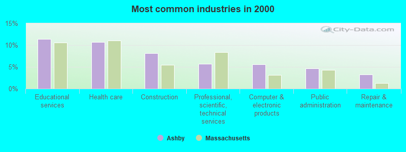
- Educational services (11.4%)
- Health care (10.7%)
- Construction (8.1%)
- Professional, scientific, technical services (5.7%)
- Computer & electronic products (5.5%)
- Public administration (4.6%)
- Repair & maintenance (3.2%)
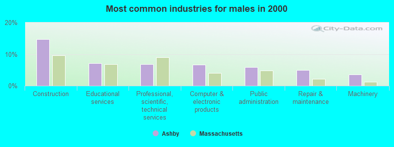
- Construction (14.7%)
- Educational services (7.2%)
- Professional, scientific, technical services (6.8%)
- Computer & electronic products (6.7%)
- Public administration (5.9%)
- Repair & maintenance (5.0%)
- Machinery (3.6%)
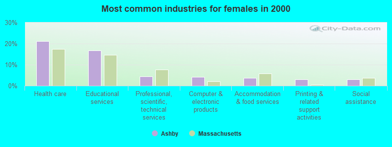
- Health care (21.2%)
- Educational services (16.6%)
- Professional, scientific, technical services (4.4%)
- Computer & electronic products (4.1%)
- Accommodation & food services (3.6%)
- Printing & related support activities (3.1%)
- Social assistance (3.1%)
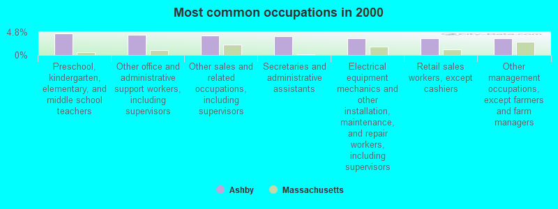
- Preschool, kindergarten, elementary, and middle school teachers (4.5%)
- Other office and administrative support workers, including supervisors (4.2%)
- Other sales and related occupations, including supervisors (4.0%)
- Secretaries and administrative assistants (3.9%)
- Electrical equipment mechanics and other installation, maintenance, and repair workers, including supervisors (3.5%)
- Retail sales workers, except cashiers (3.5%)
- Other management occupations, except farmers and farm managers (3.4%)
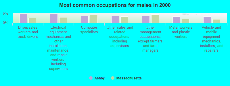
- Driver/sales workers and truck drivers (5.5%)
- Electrical equipment mechanics and other installation, maintenance, and repair workers, including supervisors (5.5%)
- Computer specialists (4.4%)
- Other sales and related occupations, including supervisors (4.3%)
- Other management occupations, except farmers and farm managers (4.2%)
- Metal workers and plastic workers (4.1%)
- Vehicle and mobile equipment mechanics, installers, and repairers (4.0%)

- Other office and administrative support workers, including supervisors (9.1%)
- Secretaries and administrative assistants (8.8%)
- Preschool, kindergarten, elementary, and middle school teachers (6.3%)
- Registered nurses (5.7%)
- Material recording, scheduling, dispatching, and distributing workers (4.5%)
- Retail sales workers, except cashiers (4.4%)
- Information and record clerks, except customer service representatives (4.2%)
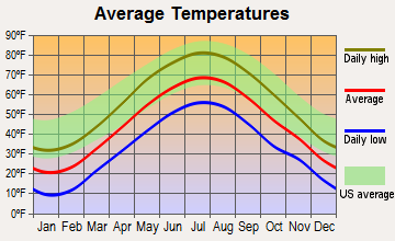
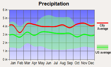
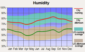
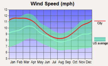
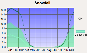
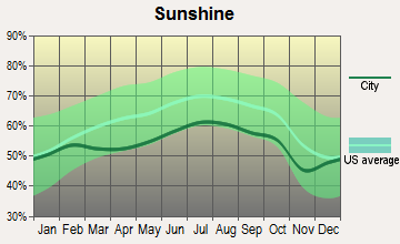
Average climate in Ashby, Massachusetts
Based on data reported by over 4,000 weather stations

(lower is better)
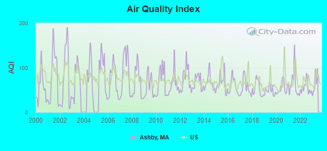
Air Quality Index (AQI) level in 2022 was 55.6. This is better than average.
| City: | 55.6 |
| U.S.: | 72.6 |
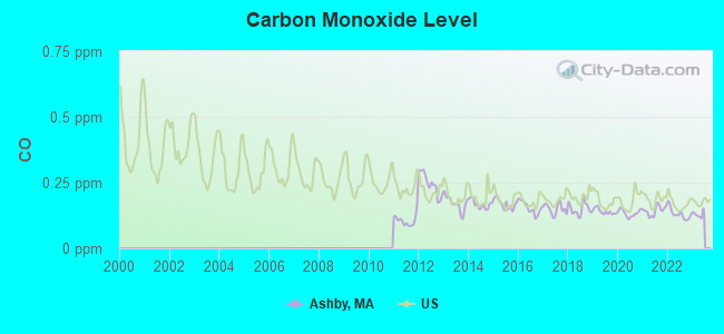
Carbon Monoxide (CO) [ppm] level in 2022 was 0.131. This is significantly better than average. Closest monitor was 13.5 miles away from the city center.
| City: | 0.131 |
| U.S.: | 0.251 |
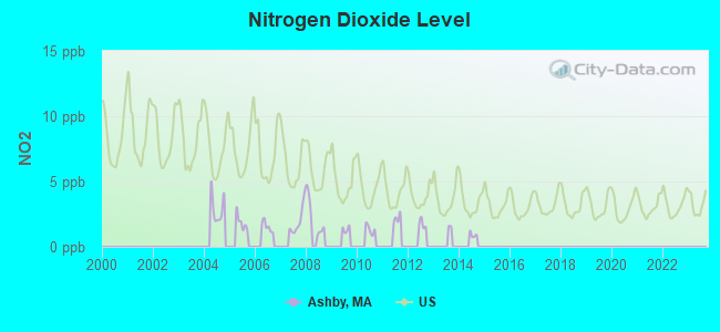
Nitrogen Dioxide (NO2) [ppb] level in 2008 was 2.27. This is significantly better than average. Closest monitor was 6.1 miles away from the city center.
| City: | 2.27 |
| U.S.: | 5.11 |
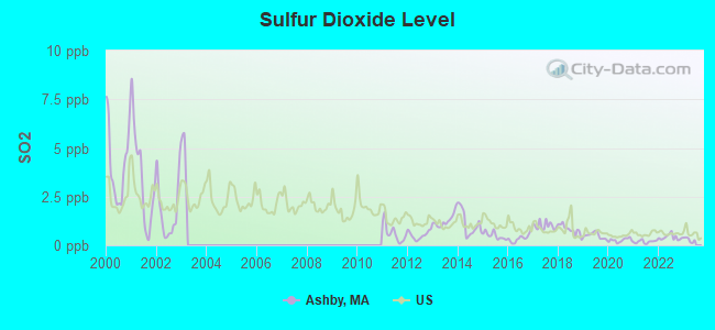
Sulfur Dioxide (SO2) [ppb] level in 2022 was 0.411. This is significantly better than average. Closest monitor was 6.0 miles away from the city center.
| City: | 0.411 |
| U.S.: | 1.515 |
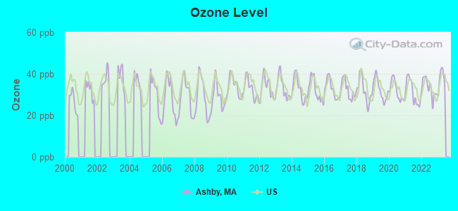
Ozone [ppb] level in 2022 was 33.2. This is about average. Closest monitor was 7.1 miles away from the city center.
| City: | 33.2 |
| U.S.: | 33.3 |
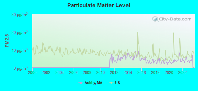
Particulate Matter (PM2.5) [µg/m3] level in 2022 was 4.18. This is significantly better than average. Closest monitor was 5.5 miles away from the city center.
| City: | 4.18 |
| U.S.: | 8.11 |
Tornado activity:
Ashby-area historical tornado activity is slightly above Massachusetts state average. It is 21% smaller than the overall U.S. average.
On 6/9/1953, a category F4 (max. wind speeds 207-260 mph) tornado 22.9 miles away from the Ashby town center killed 90 people and injured 1228 people and caused between $50,000,000 and $500,000,000 in damages.
On 6/22/1981, a category F3 (max. wind speeds 158-206 mph) tornado 9.5 miles away from the town center injured 3 people and caused between $5000 and $50,000 in damages.
Earthquake activity:
Ashby-area historical earthquake activity is significantly above Massachusetts state average. It is 71% smaller than the overall U.S. average.On 10/7/1983 at 10:18:46, a magnitude 5.3 (5.1 MB, 5.3 LG, 5.1 ML, Class: Moderate, Intensity: VI - VII) earthquake occurred 155.0 miles away from the city center
On 4/20/2002 at 10:50:47, a magnitude 5.3 (5.3 ML, Depth: 3.0 mi) earthquake occurred 158.4 miles away from Ashby center
On 4/20/2002 at 10:50:47, a magnitude 5.2 (5.2 MB, 4.2 MS, 5.2 MW, 5.0 MW) earthquake occurred 157.7 miles away from the city center
On 1/19/1982 at 00:14:42, a magnitude 4.7 (4.5 MB, 4.7 MD, 4.5 LG, Class: Light, Intensity: IV - V) earthquake occurred 58.3 miles away from the city center
On 10/16/2012 at 23:12:25, a magnitude 4.7 (4.7 ML, Depth: 10.0 mi) earthquake occurred 86.7 miles away from Ashby center
On 10/2/1994 at 11:27:22, a magnitude 3.7 (3.5 LG, 3.7 LG, Depth: 6.2 mi, Class: Light, Intensity: II - III) earthquake occurred 32.6 miles away from the city center
Magnitude types: regional Lg-wave magnitude (LG), body-wave magnitude (MB), duration magnitude (MD), local magnitude (ML), surface-wave magnitude (MS), moment magnitude (MW)
Natural disasters:
The number of natural disasters in Middlesex County (31) is a lot greater than the US average (15).Major Disasters (Presidential) Declared: 17
Emergencies Declared: 14
Causes of natural disasters: Floods: 12, Storms: 9, Hurricanes: 6, Snowstorms: 6, Winter Storms: 5, Blizzards: 2, Snows: 2, Explosion: 1, Heavy Rain: 1, Snowfall: 1, Water Main Break: 1, Wind: 1 (Note: some incidents may be assigned to more than one category).
Hospitals and medical centers near Ashby:
- BIRCHWOOD MANOR NURS HOME (Nursing Home, about 6 miles away; FITCHBURG, MA)
- GOLDEN LIVING CENTER-FITCHBURG (Nursing Home, about 6 miles away; FITCHBURG, MA)
- HIGHLANDS, THE (Nursing Home, about 6 miles away; FITCHBURG, MA)
- HIGHLANDS LTC CENTER (Nursing Home, about 6 miles away; FITCHBURG, MA)
- COMPASSIONATE HOMECARE, LLC (Home Health Center, about 7 miles away; FITCHBURG, MA)
- NAUKEAG HOSPITAL CORPORATION (Hospital, about 7 miles away; ASHBURNHAM, MA)
- HILLCREST NURSING HOME (Nursing Home, about 7 miles away; FITCHBURG, MA)
Colleges/universities with over 2000 students nearest to Ashby:
- Fitchburg State University (about 6 miles; Fitchburg, MA; Full-time enrollment: 5,010)
- Mount Wachusett Community College (about 11 miles; Gardner, MA; FT enrollment: 3,143)
- Franklin Pierce University (about 15 miles; Rindge, NH; FT enrollment: 2,139)
- Quinsigamond Community College (about 25 miles; Worcester, MA; FT enrollment: 5,877)
- University of Massachusetts-Lowell (about 25 miles; Lowell, MA; FT enrollment: 12,341)
- Assumption College (about 27 miles; Worcester, MA; FT enrollment: 2,580)
- Saint Anselm College (about 27 miles; Manchester, NH; FT enrollment: 2,059)
Public elementary/middle school in Ashby:
- ASHBY ELEMENTARY (Students: 253, Location: 911 MAIN STREET, Grades: KG-4)
Points of interest:
Notable locations in Ashby: Camp Middlesex (A), Ashby Town Hall (B), Ashby Emergency Medical Services (C), Ashby Fire Department Station 1 Headquarters (D), Ashby Free Public Library (E). Display/hide their locations on the map
Church in Ashby: Ashby Congregational Church (A). Display/hide its location on the map
Cemeteries: Glenwood Cemetery (1), West Cemetery (2). Display/hide their locations on the map
Lakes and reservoirs: Wright Ponds (A), Fitchburg Reservoir (B), Damon Pond (C), Ashby Reservoir (D), Lower Wrights Pond (E), Upper Wrights Pond (F). Display/hide their locations on the map
Streams, rivers, and creeks: Trapfall Brook (A). Display/hide its location on the map
Park in Ashby: Ashby Common (1). Display/hide its location on the map
Drinking water stations with addresses in Ashby and their reported violations in the past:
LITTLE OSSIPEE CAMPGROUND #1 (Serves ME, Population served: 100, Groundwater):Past health violations:
- MCL, Monthly (TCR) - In JUL-2012, Contaminant: Coliform. Follow-up actions: St Public Notif requested (AUG-06-2012), St Formal NOV issued (AUG-06-2012), St Public Notif received (AUG-17-2012), St Compliance achieved (SEP-06-2012)
Drinking water stations with addresses in Ashby that have no violations reported:
- LITTLE OSSIPEE LAKE CAMPGROUND #2 (Serves ME, Population served: 213, Primary Water Source Type: Groundwater)
| This town: | 2.8 people |
| Massachusetts: | 2.5 people |
| This town: | 78.0% |
| Whole state: | 63.0% |
| This town: | 7.2% |
| Whole state: | 7.0% |
Likely homosexual households (counted as self-reported same-sex unmarried-partner households)
- Lesbian couples: 0.6% of all households
- Gay men: 0.1% of all households
| This town: | 5.1% |
| Whole state: | 9.3% |
| This town: | 1.6% |
| Whole state: | 4.4% |
For population 15 years and over in Ashby:
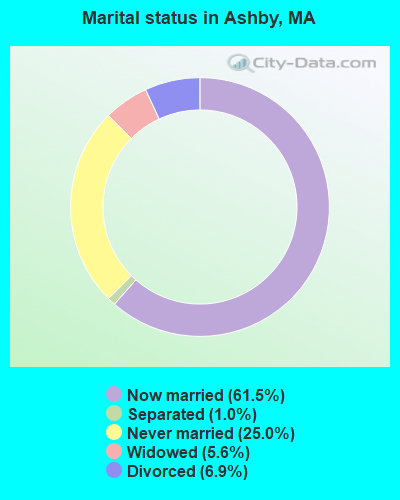
- Never married: 25.0%
- Now married: 61.5%
- Separated: 1.0%
- Widowed: 5.6%
- Divorced: 6.9%
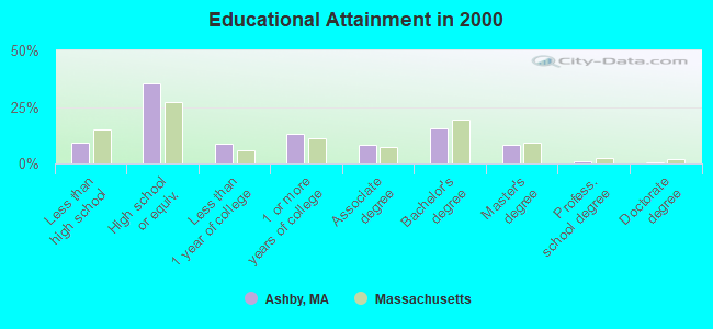
For population 25 years and over in Ashby:
- High school or higher: 90.9%
- Bachelor's degree or higher: 25.5%
- Graduate or professional degree: 10.0%
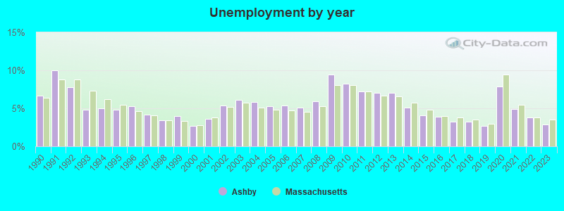
- Unemployed: 3.8%
- Mean travel time to work (commute): 31.4 minutes
| Here: | 9.7 |
| Massachusetts average: | 13.1 |


Graphs represent county-level data. Detailed 2008 Election Results
Religion statistics for Ashby, MA (based on Middlesex County data)


| Religion | Adherents | Congregations |
|---|---|---|
| Catholic | 718,209 | 107 |
| Mainline Protestant | 70,053 | 269 |
| Other | 68,480 | 199 |
| Evangelical Protestant | 41,270 | 304 |
| Orthodox | 23,641 | 28 |
| Black Protestant | 2,276 | 8 |
| None | 579,156 | - |
Food Environment Statistics:
| Middlesex County: | 1.71 / 10,000 pop. |
| Massachusetts: | 1.98 / 10,000 pop. |
| This county: | 0.03 / 10,000 pop. |
| State: | 0.05 / 10,000 pop. |
| Middlesex County: | 2.14 / 10,000 pop. |
| Massachusetts: | 2.22 / 10,000 pop. |
| Middlesex County: | 1.38 / 10,000 pop. |
| State: | 1.77 / 10,000 pop. |
| Here: | 7.84 / 10,000 pop. |
| State: | 8.76 / 10,000 pop. |
| This county: | 7.8% |
| Massachusetts: | 8.1% |
| Middlesex County: | 21.5% |
| Massachusetts: | 22.5% |
| This county: | 18.0% |
| State: | 16.5% |
6.91% of this county's 2021 resident taxpayers lived in other counties in 2020 ($102,955 average adjusted gross income)
| Here: | 6.91% |
| Massachusetts average: | 6.35% |
0.01% of residents moved from foreign countries ($137 average AGI)
Middlesex County: 0.01% Massachusetts average: 0.01%
Top counties from which taxpayers relocated into this county between 2020 and 2021:
| from Suffolk County, MA | |
| from Essex County, MA | |
| from Norfolk County, MA |
8.22% of this county's 2020 resident taxpayers moved to other counties in 2021 ($123,369 average adjusted gross income)
| Here: | 8.22% |
| Massachusetts average: | 7.18% |
0.01% of residents moved to foreign countries ($124 average AGI)
Middlesex County: 0.01% Massachusetts average: 0.02%
Top counties to which taxpayers relocated from this county between 2020 and 2021:
| to Suffolk County, MA | |
| to Essex County, MA | |
| to Worcester County, MA |
Businesses in Ashby, MA
- UPS: 1
Strongest AM radio stations in Ashby:
- WEIM (1280 AM; 5 kW; FITCHBURG, MA; Owner: LIVEAIR COMMUNICATIONS, INC.)
- WFGL (960 AM; 2 kW; FITCHBURG, MA; Owner: CSN INTERNATIONAL)
- WCRN (830 AM; 50 kW; WORCESTER, MA; Owner: CARTER BROADCASTING CORPORATION)
- WRKO (680 AM; 50 kW; BOSTON, MA; Owner: ENTERCOM BOSTON LICENSE, LLC)
- WKOX (1200 AM; 50 kW; FRAMINGHAM, MA; Owner: CAPSTAR TX LIMITED PARTNERSHIP)
- WEEI (850 AM; 50 kW; BOSTON, MA; Owner: ENTERCOM BOSTON LICENSE, LLC)
- WBIX (1060 AM; 40 kW; NATICK, MA; Owner: LANGER BROADCASTING CORPORATION)
- WVNE (760 AM; daytime; 25 kW; LEICESTER, MA; Owner: BLOUNT MASSCOM, INC.)
- WWZN (1510 AM; 50 kW; BOSTON, MA; Owner: ROSE CITY RADIO CORPORATION)
- WAMG (890 AM; 25 kW; DEDHAM, MA; Owner: MEGA COMMUNICATIONS OF DEDHAM LICENSEE, LLC)
- WNNZ (640 AM; 50 kW; WESTFIELD, MA; Owner: CLEAR CHANNEL BROADCASTING LICENSES, INC.)
- WALE (990 AM; 50 kW; GREENVILLE, RI; Owner: NORTH AMERICAN BROADCASTING CO., INC.)
- WBZ (1030 AM; 50 kW; BOSTON, MA; Owner: INFINITY BROADCASTING OPERATIONS, INC.)
Strongest FM radio stations in Ashby:
- WFEX (92.1 FM; PETERBOROUGH, NH; Owner: FNX BROADCASTING OF NEW HAMPSHIRE LLC)
- WXLO (104.5 FM; FITCHBURG, MA; Owner: CITADEL BROADCASTING COMPANY)
- WINQ (97.7 FM; WINCHENDON, MA; Owner: SAGA COMMUNICATIONS OF NEW ENGLAND, LLC)
- WGIR-FM (101.1 FM; MANCHESTER, NH; Owner: CAPSTAR TX LIMITED PARTNERSHIP)
- WAAF (107.3 FM; WORCESTER, MA; Owner: ENTERCOM BOSTON LICENSE, LLC)
- WQLL (96.5 FM; BEDFORD, NH; Owner: SAGA COMMUNICATIONS OF NEW ENGLAND, LLC)
- WLMW (90.7 FM; MANCHESTER, NH; Owner: KNOWLEDGE FOR LIFE)
- WZID (95.7 FM; MANCHESTER, NH; Owner: SAGA COMMUNICATIONS OF NEW ENGLAND, LLC)
- WSRS (96.1 FM; WORCESTER, MA; Owner: CAPSTAR TX LIMITED PARTNERSHIP)
- WHDQ (106.1 FM; CLAREMONT, NH; Owner: GREAT NORTHERN RADIO, L.L.C.)
- WBMX (98.5 FM; BOSTON, MA; Owner: INFINITY RADIO OPERATIONS INC.)
- WHOB (106.3 FM; NASHUA, NH; Owner: TELE-MEDIA COMPANY OF NEW HAMPSHIRE, L.L.C.)
- WVPR (89.5 FM; WINDSOR, VT; Owner: VERMONT PUBLIC RADIO)
- WAHL (99.9 FM; ATHOL, MA; Owner: CITADEL BROADCASTING COMPANY)
- WJMN (94.5 FM; BOSTON, MA; Owner: AMFM RADIO LICENSES, L.L.C.)
- WCRB (102.5 FM; WALTHAM, MA; Owner: CHARLES RIVER BROADCASTING WCRB LICE)
- WTKK (96.9 FM; BOSTON, MA; Owner: GREATER BOSTON RADIO, INC.)
- WROR-FM (105.7 FM; FRAMINGHAM, MA; Owner: GREATER BOSTON RADIO, INC.)
- WBOS (92.9 FM; BROOKLINE, MA; Owner: GREATER BOSTON RADIO, INC.)
- WGBH (89.7 FM; BOSTON, MA; Owner: WGBH EDUCATIONAL FOUNDATION)
TV broadcast stations around Ashby:
- WUNI (Channel 27; WORCESTER, MA; Owner: ENTRAVISION HOLDINGS, LLC)
- WUTF (Channel 66; MARLBOROUGH, MA; Owner: TELEFUTURA BOSTON LLC)
- WCVB-TV (Channel 5; BOSTON, MA; Owner: WCVB HEARST-ARGYLE TV, INC.)
- WGBH-TV (Channel 2; BOSTON, MA; Owner: WGBH EDUCATIONAL FOUNDATION)
- WHDH-TV (Channel 7; BOSTON, MA; Owner: WHDH-TV)
- WMFP (Channel 62; LAWRENCE, MA; Owner: WSAH LICENSE, INC.)
- WBZ-TV (Channel 4; BOSTON, MA; Owner: VIACOM INC.)
- WGBX-TV (Channel 44; BOSTON, MA; Owner: WGBH EDUCATIONAL FOUNDATION)
- WSBK-TV (Channel 38; BOSTON, MA; Owner: VIACOM INC.)
- WLVI-TV (Channel 56; CAMBRIDGE, MA; Owner: WLVI, INC.)
- WFXT (Channel 25; BOSTON, MA; Owner: FOX TELEVISION STATIONS INC.)
- WYDN (Channel 48; WORCESTER, MA; Owner: EDUCATIONAL PUBLIC TV CORPORATION)
- WFXZ-CA (Channel 24; BOSTON, MA; Owner: BOSTON BROADCASTING CORP.)
- WNDS (Channel 50; DERRY, NH; Owner: CTV OF DERRY, INC)
- WBPX (Channel 68; BOSTON, MA; Owner: PAXSON BOSTON-68 LICENSE, INC.)
- W40BO (Channel 40; BOSTON, MA; Owner: PAXSON COMMUNICATIONS LPTV, INC.)
- National Bridge Inventory (NBI) Statistics
- 6Number of bridges
- 16ft / 4.8mTotal length
- $3,790,000Total costs
- 17,492Total average daily traffic
- 1,171Total average daily truck traffic
- 25,586Total future (year 2015) average daily traffic
FCC Registered Cell Phone Towers:
2 (See the full list of FCC Registered Cell Phone Towers in Ashby)FCC Registered Antenna Towers:
16 (See the full list of FCC Registered Antenna Towers)FCC Registered Microwave Towers:
2- ASHBY PUBLIC, 1093 Main St (Lat: 42.680528 Lon: -71.828778), Type: Mast, Structure height: 36.6 m, Overall height: 42.7 m, Call Sign: WRPX465,
Assigned Frequencies: 11525.0 MHz, 11525.0 MHz, 11525.0 MHz, Grant Date: 04/01/2022, Expiration Date: 04/01/2032, Certifier: Fred Alden, Registrant: Modular Communications, 466 Townsend Road, Mason, NH 03048, Phone: (603) 217-2346, Email:
- CROCKER ROAD, Intersection Of Crocker Rd & Caswell Rd (Lat: 42.637000 Lon: -71.856194), Type: Mast, Structure height: 15.2 m, Overall height: 18.3 m, Call Sign: WRPX467,
Assigned Frequencies: 11035.0 MHz, 11035.0 MHz, 11035.0 MHz, Grant Date: 04/01/2022, Expiration Date: 04/01/2032, Certifier: Fred Alden, Registrant: Modular Communications, 466 Townsend Road, Mason, NH 03048, Phone: (603) 217-2346, Email:
FCC Registered Amateur Radio Licenses:
30 (See the full list of FCC Registered Amateur Radio Licenses in Ashby)FAA Registered Aircraft:
1- Aircraft: MCCALLUM MICHAEL G COZY 3 (Category: Land, Seats: 3, Weight: Up to 12,499 Pounds), Engine: Reciprocating
N-Number: 151M, N151M, N-151M, Serial Number: 216, Certificate Issue Date: 07/30/2020
Registrant (Individual): Michael G Mccallum, Po Box 331, Ashby, MA 01431
2002 - 2016 National Fire Incident Reporting System (NFIRS) incidents
- Fire incident types reported to NFIRS in Ashby, MA
- 9472.3%Structure Fires
- 2216.9%Outside Fires
- 1310.0%Mobile Property/Vehicle Fires
- 10.8%Other
 Based on the data from the years 2002 - 2016 the average number of fire incidents per year is 9. The highest number of reported fire incidents - 18 took place in 2006, and the least - 0 in 2015. The data has a declining trend.
 When looking into fire subcategories, the most reports belonged to: Structure Fires (72.3%), and Outside Fires (16.9%).
- 81.3%Fuel oil, kerosene, etc.
- 7.3%Wood
- 6.0%Utility gas
- 3.4%Bottled, tank, or LP gas
- 0.9%Electricity
- 0.6%Solar energy
- 0.4%No fuel used
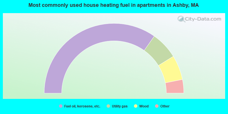
- 69.6%Fuel oil, kerosene, etc.
- 12.7%Utility gas
- 11.4%Wood
- 3.8%Bottled, tank, or LP gas
- 2.5%Electricity
Ashby compared to Massachusetts state average:
- Unemployed percentage significantly below state average.
- Black race population percentage significantly below state average.
- Hispanic race population percentage significantly below state average.
- Foreign-born population percentage significantly below state average.
- Renting percentage significantly below state average.
- Length of stay since moving in significantly above state average.
- Number of rooms per house significantly below state average.
- House age significantly below state average.

|
|
Total of 31 patent applications in 2008-2024.