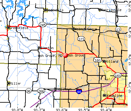
Ash Grove, Missouri
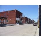
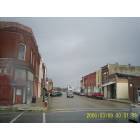
Ash Grove: downtown
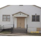
Ash Grove: American Legion
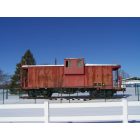
Ash Grove: Frisco Caboose in Ash Grove City Park

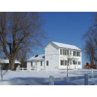
Ash Grove: Even the city Park is Historic in Nature, Ash Grove, MO
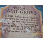
Ash Grove: ASH GROVE MISSOURI
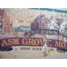
Ash Grove: PAINTING DOWNTOWN ASH GROVE IN ASH GROVE
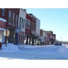
Ash Grove: Main Street Thirteen Inches of Snow
Ash Grove: Historic Eurekahaus, Built 1880's Originally 2 rooms
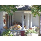
Ash Grove: Ash Grove is a Front Porch Town, This porch a good example on East Walker
Ash Grove: Ash Grove City Park Community Building
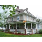
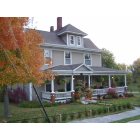
Ash Grove: East Main Street an 1890's Folk Victorian
Ash Grove: Ash Grove Main Street Looking West on a Stormy Day
- add
your
Submit your own pictures of this city and show them to the world
- OSM Map
- General Map
- Google Map
- MSN Map
Population change since 2000: +4.8%
 |
| Males: 713 | |
| Females: 786 |
| Median resident age: | 38.0 years |
| Missouri median age: | 39.1 years |
Zip codes: 65604.
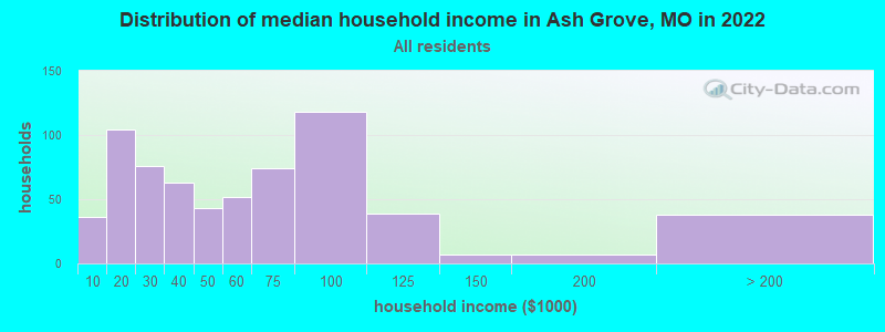
| Ash Grove: | $50,536 |
| MO: | $64,811 |
Estimated per capita income in 2022: $24,701 (it was $15,548 in 2000)
Ash Grove city income, earnings, and wages data
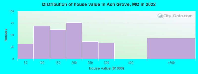
Estimated median house or condo value in 2022: $149,255 (it was $67,600 in 2000)
| Ash Grove: | $149,255 |
| MO: | $221,200 |
Mean prices in 2022: all housing units: $234,963; detached houses: $241,316; townhouses or other attached units: $242,953; in 2-unit structures: $130,625; in 3-to-4-unit structures: $146,710; in 5-or-more-unit structures: $236,353; mobile homes: $62,031; occupied boats, rvs, vans, etc.: $40,788
Median gross rent in 2022: $694.
(10.4% for White Non-Hispanic residents, 80.0% for Hispanic or Latino residents, 18.2% for two or more races residents)
Detailed information about poverty and poor residents in Ash Grove, MO
Compare current foreclosures near Ash Grove, MO:
| Photo | Address | Area | Beds / Baths | Price | Details |
|---|---|---|---|---|---|

|
#1
W Mill St
Ash Grove, MO 65604
|
1,164 sq. feet
|
2 baths 3 beds |
show details | |

|
#2
Hwy O
Ash Grove, MO 65604
|
1,791 sq. feet
|
1 baths 3 beds |
show details | |

|
#3
E Prairie Ln
Ash Grove, MO 65604
|
1,516 sq. feet
|
2 baths 2 beds |
show details | |

|
#4
714 Woodbine Rd
Ash Grove, MO 65604
|
958 sq. feet
|
1 baths 3 beds |
show details | |

|
#5
E Dade 186
Ash Grove, MO 65604
|
- sq. feet
|
- baths - beds |
show details | |

|
#6
W Harrison St
Springfield, MO 65802
|
1,011 sq. feet
|
2 baths 2 beds |
$153,000
|
show details |

|
#7
N Nettleton Ave
Springfield, MO 65802
|
768 sq. feet
|
1 baths 2 beds |
$135,000
|
show details |

|
#8
N Main Ave
Springfield, MO 65803
|
2,401 sq. feet
|
2 baths 3 beds |
$87,500
|
show details |

|
#9
E Farm Rd 84
Springfield, MO 65803
|
1,376 sq. feet
|
1 baths 3 beds |
show details | |

|
#10
W Highway Dd
Miller, MO 65707
|
1,713 sq. feet
|
2 baths 3 beds |
show details |
| Photo | Address | Area | Beds / Baths | Price | Details |
|---|---|---|---|---|---|

|
#11
Stone Creek Rd
Willard, MO 65781
|
1,318 sq. feet
|
2 baths 4 beds |
show details | |

|
#12
Hill St
Willard, MO 65781
|
1,008 sq. feet
|
2 baths 3 beds |
show details | |

|
#13
S Mahn Ave
Springfield, MO 65802
|
1,349 sq. feet
|
2 baths 3 beds |
show details | |

|
#14
Ethan Avenue
Republic, MO 65738
|
1,202 sq. feet
|
2 baths 3 beds |
show details | |

|
#15
W Calhoun St
Springfield, MO 65802
|
1,290 sq. feet
|
1 baths 3 beds |
show details | |

|
#16
W Farm Road 188
Republic, MO 65738
|
1,660 sq. feet
|
2 baths 3 beds |
show details | |

|
#17
W Cambridge St
Springfield, MO 65807
|
2,860 sq. feet
|
3 baths 5 beds |
show details | |

|
#18
N Farm Road 155
Springfield, MO 65803
|
1,438 sq. feet
|
2 baths 3 beds |
show details | |

|
#19
N Nolting Ave
Springfield, MO 65803
|
1,167 sq. feet
|
2 baths 3 beds |
show details | |

|
#20
S Ivy Cir
Springfield, MO 65802
|
1,856 sq. feet
|
2 baths 4 beds |
show details |
| Photo | Address | Area | Beds / Baths | Price | Details |
|---|---|---|---|---|---|

|
#21
S Ashton Ave
Republic, MO 65738
|
2,424 sq. feet
|
2 baths 3 beds |
show details | |

|
#22
S Forest Ct
Springfield, MO 65806
|
1,080 sq. feet
|
1 baths 3 beds |
show details | |

|
#23
S Farm Road 123
Springfield, MO 65807
|
1,337 sq. feet
|
2 baths 3 beds |
show details | |

|
#24
N Hillcrest Ave
Springfield, MO 65802
|
1,280 sq. feet
|
2 baths 3 beds |
show details | |

|
#25
E Donna St
Republic, MO 65738
|
1,398 sq. feet
|
2 baths 3 beds |
show details | |

|
#26
W Scott St
Springfield, MO 65803
|
1,139 sq. feet
|
2 baths 3 beds |
show details | |

|
#27
N Golden Ave
Springfield, MO 65802
|
1,154 sq. feet
|
2 baths 3 beds |
show details | |

|
#28
N Johnston Ave
Springfield, MO 65803
|
1,878 sq. feet
|
2 baths 5 beds |
show details | |

|
#29
W Washita St
Springfield, MO 65807
|
2,016 sq. feet
|
2 baths 2 beds |
show details | |

|
#30
Moonlight St
Republic, MO 65738
|
1,456 sq. feet
|
2 baths 3 beds |
show details |
| Photo | Address | Area | Beds / Baths | Price | Details |
|---|---|---|---|---|---|

|
#31
W Jewell Dr
Republic, MO 65738
|
1,786 sq. feet
|
2 baths 3 beds |
show details | |

|
#32
W Lynn St
Springfield, MO 65802
|
1,008 sq. feet
|
1 baths 2 beds |
show details | |

|
#33
S Timbercreek Ave
Springfield, MO 65807
|
1,585 sq. feet
|
2 baths 3 beds |
show details | |

|
#34
N Elizabeth Ave
Springfield, MO 65803
|
1,294 sq. feet
|
1 baths 3 beds |
show details | |

|
#35
S Teakwood Ave
Republic, MO 65738
|
2,500 sq. feet
|
3 baths 4 beds |
show details | |

|
#36
E Primrose St
Republic, MO 65738
|
1,131 sq. feet
|
2 baths 2 beds |
show details | |

|
#37
N Texas Ave
Republic, MO 65738
|
1,221 sq. feet
|
2 baths 3 beds |
show details | |

|
#38
S Sherwood Ave
Republic, MO 65738
|
1,470 sq. feet
|
2 baths 3 beds |
show details | |

|
#39
E Sandelwood St
Republic, MO 65738
|
1,180 sq. feet
|
2 baths 3 beds |
show details | |

|
#40
N Albertha Ave
Springfield, MO 65803
|
1,744 sq. feet
|
1 baths 3 beds |
show details |
| Photo | Address | Area | Beds / Baths | Price | Details |
|---|---|---|---|---|---|

|
#41
W Page St
Springfield, MO 65802
|
900 sq. feet
|
1 baths 2 beds |
show details | |

|
#42
E Sequoia St
Republic, MO 65738
|
2,068 sq. feet
|
3 baths 4 beds |
show details | |

|
#43
N Basswood Ave
Republic, MO 65738
|
1,404 sq. feet
|
2 baths 3 beds |
show details | |

|
#44
W State St
Springfield, MO 65802
|
864 sq. feet
|
1 baths 2 beds |
show details | |

|
#45
E Hines St
Republic, MO 65738
|
1,467 sq. feet
|
1 baths 3 beds |
show details | |

|
#46
S Hampton Ave
Republic, MO 65738
|
1,624 sq. feet
|
2 baths 3 beds |
show details | |

|
#47
W Dale St
Springfield, MO 65803
|
1,026 sq. feet
|
1 baths 2 beds |
show details | |

|
#48
E Lee St
Republic, MO 65738
|
3,046 sq. feet
|
3 baths 4 beds |
show details | |

|
#49
N Fulbright Ave
Springfield, MO 65802
|
999 sq. feet
|
1 baths 2 beds |
show details | |

|
Check over 1 million property listings on Foreclosure.com!
|
browse all offers | |||


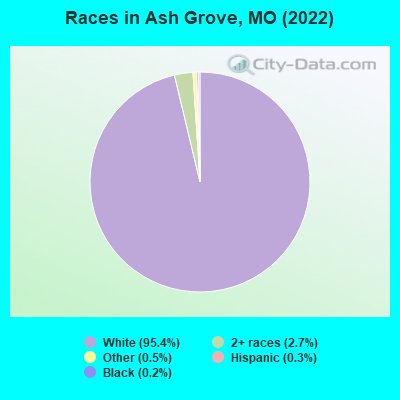
- 1,56495.4%White alone
- 442.7%Two or more races
- 80.5%Other race alone
- 50.3%Hispanic
- 40.2%Black alone
Races in Ash Grove detailed stats: ancestries, foreign born residents, place of birth
According to our research of Missouri and other state lists, there were 14 registered sex offenders living in Ash Grove, Missouri as of May 07, 2024.
The ratio of all residents to sex offenders in Ash Grove is 117 to 1.
Type |
2009 |
2010 |
2011 |
2012 |
2013 |
2014 |
2015 |
2016 |
2017 |
2018 |
2019 |
2020 |
2021 |
2022 |
|---|---|---|---|---|---|---|---|---|---|---|---|---|---|---|
| Murders (per 100,000) | 0 (0.0) | 0 (0.0) | 0 (0.0) | 0 (0.0) | 0 (0.0) | 0 (0.0) | 0 (0.0) | 0 (0.0) | 0 (0.0) | 0 (0.0) | 0 (0.0) | 0 (0.0) | 0 (0.0) | 0 (0.0) |
| Rapes (per 100,000) | 0 (0.0) | 0 (0.0) | 0 (0.0) | 0 (0.0) | 0 (0.0) | 0 (0.0) | 1 (68.0) | 0 (0.0) | 0 (0.0) | 0 (0.0) | 0 (0.0) | 2 (138.8) | 0 (0.0) | 1 (66.4) |
| Robberies (per 100,000) | 0 (0.0) | 0 (0.0) | 0 (0.0) | 0 (0.0) | 0 (0.0) | 0 (0.0) | 0 (0.0) | 0 (0.0) | 0 (0.0) | 0 (0.0) | 0 (0.0) | 0 (0.0) | 0 (0.0) | 0 (0.0) |
| Assaults (per 100,000) | 0 (0.0) | 0 (0.0) | 2 (135.4) | 1 (67.3) | 2 (135.2) | 2 (134.8) | 2 (136.0) | 2 (136.5) | 3 (207.5) | 0 (0.0) | 2 (138.2) | 9 (624.6) | 8 (555.6) | 14 (929.6) |
| Burglaries (per 100,000) | 10 (649.4) | 6 (407.6) | 21 (1,422) | 8 (538.7) | 3 (202.8) | 3 (202.2) | 26 (1,768) | 24 (1,638) | 3 (207.5) | 4 (276.2) | 4 (276.4) | 16 (1,110) | 39 (2,708) | 12 (796.8) |
| Thefts (per 100,000) | 9 (584.4) | 21 (1,427) | 18 (1,219) | 26 (1,751) | 25 (1,690) | 14 (943.4) | 27 (1,835) | 43 (2,935) | 14 (968.2) | 11 (759.7) | 23 (1,589) | 17 (1,180) | 19 (1,319) | 17 (1,129) |
| Auto thefts (per 100,000) | 1 (64.9) | 1 (67.9) | 2 (135.4) | 2 (134.7) | 2 (135.2) | 0 (0.0) | 1 (68.0) | 0 (0.0) | 0 (0.0) | 2 (138.1) | 1 (69.1) | 3 (208.2) | 5 (347.2) | 3 (199.2) |
| Arson (per 100,000) | 1 (64.9) | 0 (0.0) | 0 (0.0) | 1 (67.3) | 0 (0.0) | 0 (0.0) | 1 (68.0) | 0 (0.0) | 0 (0.0) | 0 (0.0) | 1 (69.1) | 0 (0.0) | 0 (0.0) | 1 (66.4) |
| City-Data.com crime index | 74.0 | 91.0 | 186.2 | 132.0 | 119.7 | 78.8 | 284.2 | 259.4 | 94.7 | 60.8 | 116.1 | 377.5 | 381.2 | 355.9 |
The City-Data.com crime index weighs serious crimes and violent crimes more heavily. Higher means more crime, U.S. average is 246.1. It adjusts for the number of visitors and daily workers commuting into cities.
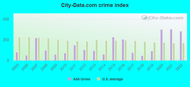
Crime rate in Ash Grove detailed stats: murders, rapes, robberies, assaults, burglaries, thefts, arson
Full-time law enforcement employees in 2019, including police officers: 11 (5 officers - 5 male; 0 female).
| Officers per 1,000 residents here: | 3.46 |
| Missouri average: | 2.48 |
 Recent articles from our blog. Our writers, many of them Ph.D. graduates or candidates, create easy-to-read articles on a wide variety of topics.

 | Ash Grove (1 reply) |
| Your Feedback on these Springfield Suburbs (13 replies) |
| What towns are 30 Minutes or less of Springfield? (12 replies) |
| HOWS LIFE IN SPRINGFIELD MO AREA? Considering moving there (45 replies) |
| Jobs in Missouri? What's it like living there? (52 replies) |
| Strong possible relocation for homeschool family from Illinois (18 replies) |
Latest news from Ash Grove, MO collected exclusively by city-data.com from local newspapers, TV, and radio stations
Ancestries: English (25.5%), German (15.6%), American (10.6%), Czech (5.3%), Irish (4.0%), European (2.0%).
Current Local Time: CST time zone
Incorporated in 1871
Elevation: 1042 feet
Land area: 1.19 square miles.
Population density: 1,262 people per square mile (low).
3 residents are foreign born
| This city: | 0.2% |
| Missouri: | 4.2% |
Median real estate property taxes paid for housing units with mortgages in 2022: $1,077 (0.7%)
Median real estate property taxes paid for housing units with no mortgage in 2022: $1,025 (0.7%)
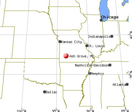
Nearest city with pop. 50,000+: Springfield, MO  (18.4 miles , pop. 151,580).
Nearest city with pop. 200,000+: Kansas City, MO (132.7 miles , pop. 441,545).
Nearest city with pop. 1,000,000+: Dallas, TX (361.1 miles , pop. 1,188,580).
Nearest cities:
), ), ), ), ), Latitude: 37.32 N, Longitude: 93.58 W
Area code: 417
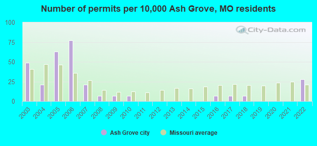
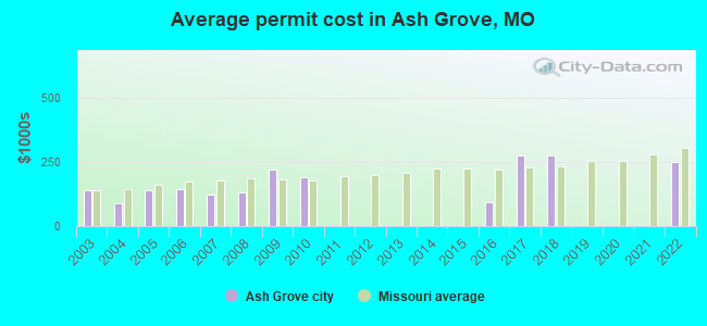
Single-family new house construction building permits:
- 2022: 4 buildings, average cost: $250,000
- 2018: 1 building, cost: $275,000
- 2017: 1 building, cost: $275,000
- 2016: 1 building, cost: $95,000
- 2010: 1 building, cost: $191,000
- 2009: 1 building, cost: $220,000
- 2008: 1 building, cost: $133,000
- 2007: 3 buildings, average cost: $120,800
- 2006: 11 buildings, average cost: $143,700
- 2005: 9 buildings, average cost: $141,200
- 2004: 3 buildings, average cost: $90,000
- 2003: 7 buildings, average cost: $138,400
| Here: | 2.3% |
| Missouri: | 2.8% |
- Educational services (13.0%)
- Health care (12.5%)
- Accommodation & food services (5.6%)
- Construction (5.4%)
- Religious, grantmaking, civic, professional, similar organizations (3.6%)
- Metal & metal products (3.2%)
- Administrative & support & waste management services (3.0%)
- Construction (10.1%)
- Educational services (7.9%)
- Metal & metal products (5.9%)
- Health care (5.1%)
- Religious, grantmaking, civic, professional, similar organizations (4.5%)
- Administrative & support & waste management services (4.2%)
- Groceries & related products merchant wholesalers (4.2%)
- Health care (21.2%)
- Educational services (18.9%)
- Accommodation & food services (7.8%)
- Social assistance (5.2%)
- Food & beverage stores (4.6%)
- Transportation equipment (4.2%)
- Religious, grantmaking, civic, professional, similar organizations (2.6%)
- Building and grounds cleaning and maintenance occupations (7.4%)
- Other production occupations, including supervisors (6.3%)
- Preschool, kindergarten, elementary, and middle school teachers (5.0%)
- Laborers and material movers, hand (4.8%)
- Other office and administrative support workers, including supervisors (4.4%)
- Metal workers and plastic workers (3.9%)
- Other management occupations, except farmers and farm managers (3.2%)
- Other production occupations, including supervisors (9.3%)
- Building and grounds cleaning and maintenance occupations (8.7%)
- Metal workers and plastic workers (7.3%)
- Laborers and material movers, hand (7.0%)
- Driver/sales workers and truck drivers (5.6%)
- Vehicle and mobile equipment mechanics, installers, and repairers (5.1%)
- Electrical equipment mechanics and other installation, maintenance, and repair workers, including supervisors (4.5%)

- Preschool, kindergarten, elementary, and middle school teachers (8.5%)
- Other office and administrative support workers, including supervisors (7.8%)
- Building and grounds cleaning and maintenance occupations (5.9%)
- Cashiers (5.5%)
- Secretaries and administrative assistants (4.6%)
- Cooks and food preparation workers (4.2%)
- Health technologists and technicians (3.9%)
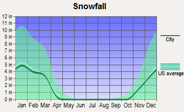
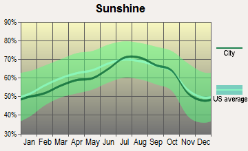
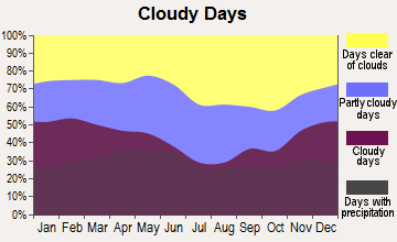
Average climate in Ash Grove, Missouri
Based on data reported by over 4,000 weather stations
|
|


(lower is better)
Air Quality Index (AQI) level in 2022 was 70.1. This is about average.
| City: | 70.1 |
| U.S.: | 72.6 |
Carbon Monoxide (CO) [ppm] level in 2010 was 0.246. This is about average. Closest monitor was 18.3 miles away from the city center.
| City: | 0.246 |
| U.S.: | 0.251 |
Nitrogen Dioxide (NO2) [ppb] level in 2010 was 7.97. This is significantly worse than average. Closest monitor was 16.2 miles away from the city center.
| City: | 7.97 |
| U.S.: | 5.11 |
Sulfur Dioxide (SO2) [ppb] level in 2010 was 1.84. This is worse than average. Closest monitor was 12.4 miles away from the city center.
| City: | 1.84 |
| U.S.: | 1.51 |
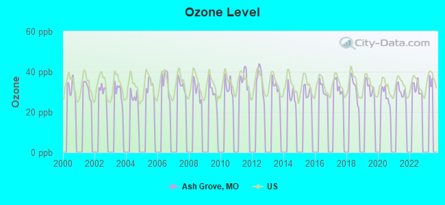
Ozone [ppb] level in 2022 was 31.8. This is about average. Closest monitor was 16.2 miles away from the city center.
| City: | 31.8 |
| U.S.: | 33.3 |
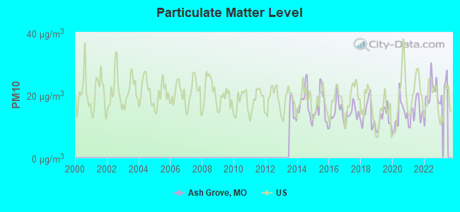
Particulate Matter (PM10) [µg/m3] level in 2022 was 20.4. This is about average. Closest monitor was 16.2 miles away from the city center.
| City: | 20.4 |
| U.S.: | 19.2 |
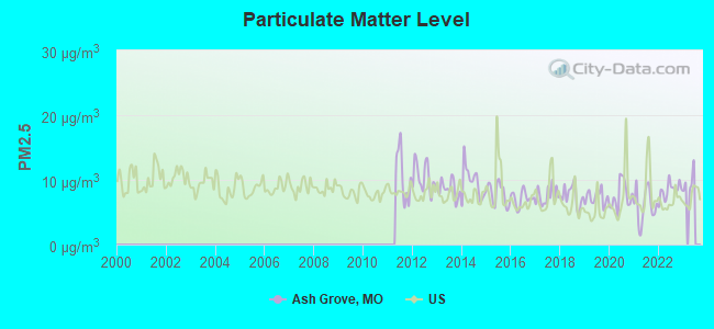
Particulate Matter (PM2.5) [µg/m3] level in 2022 was 8.38. This is about average. Closest monitor was 16.2 miles away from the city center.
| City: | 8.38 |
| U.S.: | 8.11 |
Tornado activity:
Ash Grove-area historical tornado activity is near Missouri state average. It is 49% greater than the overall U.S. average.
On 11/29/1991, a category F4 (max. wind speeds 207-260 mph) tornado 21.6 miles away from the Ash Grove city center killed 2 people and injured 64 people and caused between $5,000,000 and $50,000,000 in damages.
On 3/26/1976, a category F3 (max. wind speeds 158-206 mph) tornado 9.6 miles away from the city center killed one person and injured 3 people and caused between $50,000 and $500,000 in damages.
Earthquake activity:
Ash Grove-area historical earthquake activity is significantly above Missouri state average. It is 570% greater than the overall U.S. average.On 9/3/2016 at 12:02:44, a magnitude 5.8 (5.8 MW, Depth: 3.5 mi, Class: Moderate, Intensity: VI - VII) earthquake occurred 195.1 miles away from Ash Grove center
On 11/6/2011 at 03:53:10, a magnitude 5.7 (5.7 MW, Depth: 3.2 mi) earthquake occurred 215.8 miles away from Ash Grove center
On 11/7/2016 at 01:44:24, a magnitude 5.0 (5.0 MW, Depth: 2.8 mi) earthquake occurred 200.8 miles away from Ash Grove center
On 5/4/1991 at 01:18:54, a magnitude 5.0 (4.4 MB, 4.6 LG, 5.0 LG, Depth: 3.1 mi) earthquake occurred 214.3 miles away from the city center
On 3/25/1976 at 00:41:20, a magnitude 5.0 (4.9 MB, 5.0 LG) earthquake occurred 215.1 miles away from the city center
On 2/28/2011 at 05:00:50, a magnitude 4.7 (4.7 MW, Depth: 2.0 mi, Class: Light, Intensity: IV - V) earthquake occurred 157.3 miles away from the city center
Magnitude types: regional Lg-wave magnitude (LG), body-wave magnitude (MB), moment magnitude (MW)
Natural disasters:
The number of natural disasters in Greene County (23) is greater than the US average (15).Major Disasters (Presidential) Declared: 14
Emergencies Declared: 6
Causes of natural disasters: Floods: 15, Storms: 14, Tornadoes: 8, Winter Storms: 6, Winds: 3, Drought: 1, Hurricane: 1, Other: 1 (Note: some incidents may be assigned to more than one category).
Hospitals and medical centers in Ash Grove:
Other hospitals and medical centers near Ash Grove:
- WILLARD CARE CENTRE INC (Nursing Home, about 9 miles away; WILLARD, MO)
- SPRINGFIELD SKILLED CARE CENTER (Nursing Home, about 15 miles away; SPRINGFIELD, MO)
- SUNBRIDGE CARE AND REHAB FOR SPRINGFIELD (Nursing Home, about 15 miles away; SPRINGFIELD, MO)
- DADE COUNTY NURSING HOME DISTRICT (Nursing Home, about 16 miles away; GREENFIELD, MO)
- SONSHINE MANOR (Nursing Home, about 16 miles away; REPUBLIC, MO)
- SEASONS HOSPICE, INC (Hospital, about 16 miles away; SPRINGFIELD, MO)
Colleges/universities with over 2000 students nearest to Ash Grove:
- Drury University (about 18 miles; Springfield, MO; Full-time enrollment: 3,902)
- Ozarks Technical Community College (about 19 miles; Springfield, MO; FT enrollment: 10,356)
- Missouri State University-Springfield (about 19 miles; Springfield, MO; FT enrollment: 16,660)
- Evangel University (about 19 miles; Springfield, MO; FT enrollment: 2,036)
- Southwest Baptist University (about 22 miles; Bolivar, MO; FT enrollment: 2,783)
- Missouri Southern State University (about 51 miles; Joplin, MO; FT enrollment: 4,456)
- Crowder College (about 56 miles; Neosho, MO; FT enrollment: 3,675)
Public high school in Ash Grove:
- ASH GROVE HIGH (Students: 321, Location: 100 N MAPLE LN, Grades: 7-12)
Public elementary/middle school in Ash Grove:
- ASH GROVE ELEM. (Students: 421, Location: 100 N MAPLE LN, Grades: PK-3)
Points of interest:
Notable location: Ash Grove Fire Protection District (A). Display/hide its location on the map
Cemetery: Hamilton Cemetery (1). Display/hide its location on the map
Tourist attraction: Ozarks Afro-American Heritage Museum (Cultural Attractions- Events- & Facilities; 107 West Main).
Birthplace of: Jeremy Nicholson - College basketball player (Missouri State Bears).
Drinking water stations with addresses in Ash Grove and their reported violations in the past:
ASH GROVE (Population served: 1,472, Groundwater):Past health violations:NATHAN BOONE STATE HISTORICAL SITE (Address: 7850 N STATE HIGHWAY V , Population served: 25, Groundwater):Past monitoring violations:
- MCL, Monthly (TCR) - In APR-2014, Contaminant: Coliform. Follow-up actions: St Formal NOV issued (APR-18-2014), St Public Notif requested (APR-18-2014), St Public Notif received (MAY-07-2014)
- MCL, Monthly (TCR) - In AUG-2012, Contaminant: Coliform. Follow-up actions: St Formal NOV issued (SEP-05-2012), St Public Notif requested (SEP-05-2012), St Compliance achieved (JAN-22-2014), St Public Notif received (MAY-07-2014)
- MCL, Monthly (TCR) - In FEB-2010, Contaminant: Coliform. Follow-up actions: St Public Notif received (MAR-22-2010), St Compliance achieved (JAN-22-2014)
- Lead Consumer Notice - In JAN-01-2012, Contaminant: Lead and Copper Rule. Follow-up actions: St Compliance achieved (JUN-06-2012)
- Follow-up Or Routine LCR Tap M/R - In OCT-01-2010, Contaminant: Lead and Copper Rule. Follow-up actions: St Public Notif requested (NOV-10-2010), St Violation/Reminder Notice (NOV-10-2010), St Public Notif received (JUN-17-2011), St Compliance achieved (OCT-20-2011)
Past health violations:Past monitoring violations:
- MCL, Monthly (TCR) - In JUN-2010, Contaminant: Coliform. Follow-up actions: St Public Notif requested (JUL-01-2010), St Violation/Reminder Notice (JUL-01-2010), St Public Notif received (AUG-09-2010), St Compliance achieved (JUL-18-2011)
- Monitoring, Source Water (GWR) - In JUN-01-2011, Contaminant: E. COLI. Follow-up actions: St Public Notif requested (JUL-20-2011), St Violation/Reminder Notice (JUL-20-2011), St Public Notif received (AUG-22-2011)
- 2 routine major monitoring violations
- One minor monitoring violation
| This city: | 2.4 people |
| Missouri: | 2.5 people |
| This city: | 64.9% |
| Whole state: | 65.3% |
| This city: | 6.8% |
| Whole state: | 6.7% |
Likely homosexual households (counted as self-reported same-sex unmarried-partner households)
- Lesbian couples: 0.7% of all households
- Gay men: 0.2% of all households
Banks with branches in Ash Grove (2011 data):
- Bank of Ash Grove: Bank Of Ash Grove at 218 N Webster Ave, branch established on 1883/04/13. Info updated 2009/12/07: Bank assets: $75.8 mil, Deposits: $57.6 mil, local headquarters, positive income, 2 total offices
For population 15 years and over in Ash Grove:
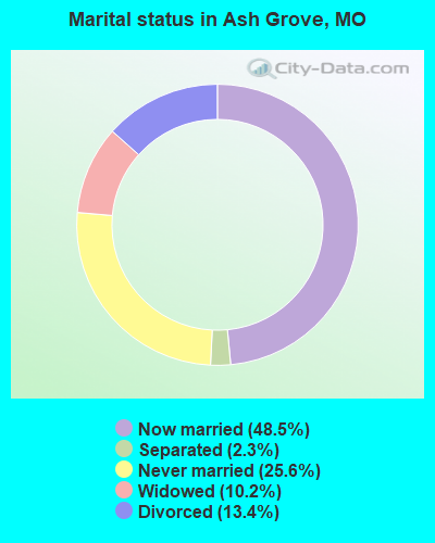
- Never married: 25.6%
- Now married: 48.5%
- Separated: 2.3%
- Widowed: 10.2%
- Divorced: 13.4%
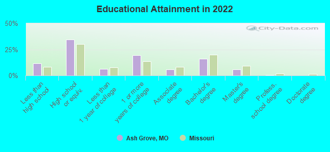
For population 25 years and over in Ash Grove:
- High school or higher: 89.0%
- Bachelor's degree or higher: 22.7%
- Graduate or professional degree: 7.0%
- Unemployed: 2.1%
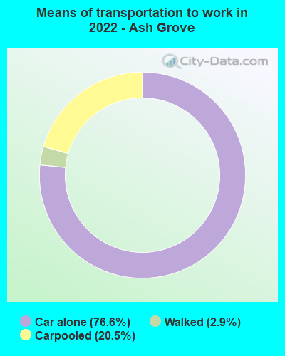
- Mean travel time to work (commute): 23.0 minutes
| Here: | 9.9 |
| Missouri average: | 11.1 |

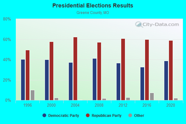
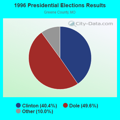
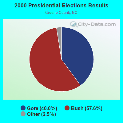

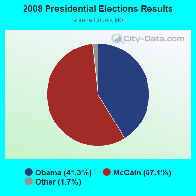


Graphs represent county-level data. Detailed 2008 Election Results
Religion statistics for Ash Grove, MO (based on Greene County data)
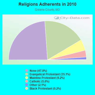
| Religion | Adherents | Congregations |
|---|---|---|
| Evangelical Protestant | 96,521 | 258 |
| Mainline Protestant | 25,250 | 59 |
| Catholic | 15,294 | 6 |
| Other | 5,731 | 26 |
| Black Protestant | 624 | 4 |
| Orthodox | 121 | 2 |
| None | 131,633 | - |
Food Environment Statistics:
| Greene County: | 1.33 / 10,000 pop. |
| Missouri: | 1.88 / 10,000 pop. |
| Greene County: | 0.23 / 10,000 pop. |
| Missouri: | 0.18 / 10,000 pop. |
| This county: | 0.15 / 10,000 pop. |
| Missouri: | 0.60 / 10,000 pop. |
| Greene County: | 3.60 / 10,000 pop. |
| State: | 4.34 / 10,000 pop. |
| Greene County: | 8.11 / 10,000 pop. |
| Missouri: | 7.37 / 10,000 pop. |
| This county: | 8.0% |
| Missouri: | 8.8% |
| Greene County: | 29.1% |
| Missouri: | 29.6% |
| Here: | 12.3% |
| Missouri: | 13.5% |
Health and Nutrition:
| Ash Grove: | 49.8% |
| Missouri: | 50.9% |
| Ash Grove: | 47.5% |
| Missouri: | 48.6% |
| Ash Grove: | 29.0 |
| Missouri: | 28.7 |
| Here: | 23.2% |
| Missouri: | 20.6% |
| This city: | 9.5% |
| Missouri: | 10.1% |
| Here: | 6.8 |
| Missouri: | 6.8 |
| Here: | 37.4% |
| State: | 34.3% |
| Ash Grove: | 56.4% |
| Missouri: | 57.5% |
| Here: | 77.7% |
| Missouri: | 79.3% |
More about Health and Nutrition of Ash Grove, MO Residents
| Local government employment and payroll (March 2022) | |||||
| Function | Full-time employees | Monthly full-time payroll | Average yearly full-time wage | Part-time employees | Monthly part-time payroll |
|---|---|---|---|---|---|
| Police Protection - Officers | 4 | $18,711 | $56,133 | 5 | $1,554 |
| Water Supply | 2 | $6,991 | $41,946 | 0 | $0 |
| Other and Unallocable | 1 | $5,646 | $67,752 | 0 | $0 |
| Financial Administration | 1 | $4,568 | $54,816 | 0 | $0 |
| Parks and Recreation | 0 | $0 | 1 | $3,984 | |
| Totals for Government | 8 | $35,916 | $53,874 | 6 | $5,538 |
Ash Grove government finances - Expenditure in 2017 (per resident):
- Current Operations - General - Other: $290,000 ($193.46)
Water Utilities: $275,000 ($183.46)
Police Protection: $269,000 ($179.45)
Sewerage: $263,000 ($175.45)
Financial Administration: $149,000 ($99.40)
Parks and Recreation: $119,000 ($79.39)
Regular Highways: $110,000 ($73.38)
Judicial and Legal Services: $7,000 ($4.67)
Protective Inspection and Regulation - Other: $2,000 ($1.33)
- Total Salaries and Wages: $1,526,000 ($1018.01)
- Water Utilities - Interest on Debt: $2,482,000 ($1655.77)
Ash Grove government finances - Revenue in 2017 (per resident):
- Charges - Sewerage: $181,000 ($120.75)
Parks and Recreation: $7,000 ($4.67)
- Local Intergovernmental - Other: $2,000 ($1.33)
- Miscellaneous - Fines and Forfeits: $9,000 ($6.00)
Interest Earnings: $8,000 ($5.34)
Rents: $4,000 ($2.67)
- Revenue - Water Utilities: $262,000 ($174.78)
- State Intergovernmental - Highways: $59,000 ($39.36)
- Tax - General Sales and Gross Receipts: $331,000 ($220.81)
Property: $104,000 ($69.38)
Public Utilities Sales: $92,000 ($61.37)
Occupation and Business License - Other: $2,000 ($1.33)
Alcoholic Beverage License: $1,000 ($0.67)
Ash Grove government finances - Debt in 2017 (per resident):
- Long Term Debt - Beginning Outstanding - Unspecified Public Purpose: $62,042,000 ($41388.93)
Outstanding Unspecified Public Purpose: $61,985,000 ($41350.90)
Retired Unspecified Public Purpose: $58,000 ($38.69)
Ash Grove government finances - Cash and Securities in 2017 (per resident):
- Other Funds - Cash and Securities: $1,591,000 ($1061.37)
| Businesses in Ash Grove, MO | ||||
| Name | Count | Name | Count | |
|---|---|---|---|---|
| MasterBrand Cabinets | 1 | U-Haul | 1 | |
| True Value | 1 | YMCA | 1 | |
Strongest AM radio stations in Ash Grove:
- KSGF (1260 AM; 5 kW; SPRINGFIELD, MO; Owner: JOURNAL BROADCAST CORPORATION)
- KLFJ (1550 AM; 5 kW; SPRINGFIELD, MO; Owner: 127, INC.)
- KWTO (560 AM; 5 kW; SPRINGFIELD, MO; Owner: KWTO, INC.)
- KKOW (860 AM; 10 kW; PITTSBURG, KS; Owner: AMERICAN MEDIA INVESTMENTS)
- KMRF (1510 AM; daytime; 5 kW; MARSHFIELD, MO; Owner: NEW LIFE EVANGELISTIC CENTER, INC.)
- WHB (810 AM; 50 kW; KANSAS CITY, MO; Owner: UNION BROADCASTING, INC.)
- KKLL (1100 AM; daytime; 5 kW; WEBB CITY, MO; Owner: NEW LIFE EVANGELISTIC CENTER, INC.)
- KBTN (1420 AM; 10 kW; NEOSHO, MO; Owner: PETRACOM OF JOPLIN, L.L.C.)
- KGMY (1400 AM; 1 kW; SPRINGFIELD, MO; Owner: CLEAR CHANNEL BROADCASTING LICENSES, INC.)
- KRMO (990 AM; 2 kW; CASSVILLE, MO; Owner: MONETT COMMUNICATIONS, INC.)
- KRMG (740 AM; 50 kW; TULSA, OK; Owner: CXR HOLDINGS, INC.)
- WMBH (1560 AM; 10 kW; JOPLIN, MO)
- KBNN (750 AM; daytime; 5 kW; LEBANON, MO; Owner: OZARK BROADCASTING, INC.)
Strongest FM radio stations in Ash Grove:
- KOSP (105.1 FM; WILLARD, MO; Owner: MW SPRINGMO, INC.)
- KZRQ (104.1 FM; ASH GROVE, MO; Owner: CITADEL BROADCASTING COMPANY)
- KTTS-FM (94.7 FM; SPRINGFIELD, MO; Owner: JOURNAL BROADCAST CORPORATION)
- KGMY-FM (100.5 FM; AURORA, MO; Owner: CLEAR CHANNEL BROADCASTING LICENSES, INC.)
- KTXR (101.3 FM; SPRINGFIELD, MO; Owner: STEREO BROADCASTING, INC.)
- KGBX-FM (105.9 FM; NIXA, MO; Owner: CLEAR CHANNEL BROADCASTING LICENSES, INC.)
- KHTO (106.7 FM; MOUNT VERNON, MO; Owner: CITADEL BROADCASTING COMPANY)
- KTOZ-FM (95.5 FM; PLEASANT HOPE, MO; Owner: CLEAR CHANNEL BROADCASTING LICENSES, INC.)
- KXUS (97.3 FM; SPRINGFIELD, MO; Owner: CLEAR CHANNEL BROADCASTING LICENSES, INC.)
- KWFC (89.1 FM; SPRINGFIELD, MO; Owner: BAPTIST BIBLE COLLEGE, INC.)
- KADI (99.5 FM; REPUBLIC, MO; Owner: VISION COMMUNICATIONS, INCORPORATED)
- KSMU (91.1 FM; SPRINGFIELD, MO; Owner: BD OF REGENTS FOR SW MO ST UNIV)
- KWTO-FM (98.7 FM; SPRINGFIELD, MO; Owner: KWTO, INC.)
- KRLK (107.7 FM; STOCKTON, MO; Owner: KRLK RADIO, INC.)
- KSCV (90.1 FM; SPRINGFIELD, MO; Owner: COMMUNITY BROADCASTING, INC.)
- KOMG (92.9 FM; OZARK, MO; Owner: MW SPRINGMO, INC.)
- KBFL (99.9 FM; BUFFALO, MO; Owner: MEYER-BALDRIDGE, INC.)
- K265DR (100.9 FM; BOLIVAR, MO; Owner: RADIO TRAINING NETWORK, INC.)
TV broadcast stations around Ash Grove:
- KYTV (Channel 3; SPRINGFIELD, MO; Owner: KY3, INC.)
- KOZK (Channel 21; SPRINGFIELD, MO; Owner: BD. OF GOVERNORS OF SW MISSOURI STATE UNIVERSITY)
- KSPR (Channel 33; SPRINGFIELD, MO; Owner: PIEDMONT TELEVISION OF SPRINGFIELD LICENSE LLC)
- KOLR (Channel 10; SPRINGFIELD, MO; Owner: VHR SPRINGFIELD LICENSE, INC.)
- KDEB-TV (Channel 27; SPRINGFIELD, MO; Owner: QUORUM OF MISSOURI LICENSE, LLC)
- K15CZ (Channel 15; SPRINGFIELD, MO; Owner: KY3, INC.)
- K41FQ (Channel 41; SPRINGFIELD, MO; Owner: TRINITY BROADCASTING NETWORK)
- KWBS-LP (Channel 56; SPRINGFIELD, MO; Owner: EQUITY BROADCASTING CORPORATION)
- K54FX (Channel 54; SPRINGFIELD, MO; Owner: NEW LIFE EVANGELISTIC CENTER, INC.)
- K08MA (Channel 8; SPRINGFIELD, MO; Owner: METROPOLITAN RADIO GROUP, INC.)
- K49DG (Channel 49; SPRINGFIELD, MO; Owner: TRINITY BROADCASTING NETWORK)
Ash Grove fatal accident list:
Sep 19, 1992 08:05 AM, F, Vehicles: 1, Persons: 1, Fatalities: 1
Jun 15, 1984 06:40 PM, 160, Vehicles: 3, Persons: 3, Fatalities: 1
- National Bridge Inventory (NBI) Statistics
- 30Number of bridges
- 299ft / 91.2mTotal length
- $3,303,000Total costs
- 15,376Total average daily traffic
- 1,180Total average daily truck traffic
- 25,547Total future (year 2040) average daily traffic
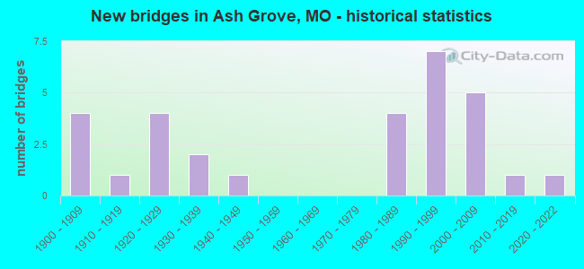
- New bridges - historical statistics
- 41900-1909
- 11910-1919
- 41920-1929
- 21930-1939
- 11940-1949
- 41980-1989
- 71990-1999
- 52000-2009
- 12010-2019
- 12020-2022
FCC Registered Cell Phone Towers:
1 (See the full list of FCC Registered Cell Phone Towers in Ash Grove)FCC Registered Antenna Towers:
61 (See the full list of FCC Registered Antenna Towers)FCC Registered Private Land Mobile Towers:
1- Near Intersection Of Fr60 And Fr53, Ne Of (Lat: 37.336417 Lon: -93.536861), Type: Tower, Structure height: 182.8 m, Overall height: 188.9 m, Call Sign: WQJD685,
Assigned Frequencies: 860.212 MHz, 860.437 MHz, 860.712 MHz, 860.762 MHz, 860.962 MHz, Grant Date: 01/26/2008, Expiration Date: 07/28/2013, Cancellation Date: 11/09/2011, Certifier: Rick Edwards, Registrant: Sprint Nextel Corporation, 12502 Sunrise Valley Drive, M/S: Varesa0209, Reston, VA 20196, Phone: (703) 433-4000, Fax: (703) 433-4483
FCC Registered Microwave Towers:
5- CLOWNFISH, 6657 State Hwy O (Lat: 37.186444 Lon: -93.641500), Type: Mast, Structure height: 91.4 m, Overall height: 94.1 m, Call Sign: WQRL291,
Assigned Frequencies: 6034.15 MHz, Grant Date: 05/09/2023, Expiration Date: 06/10/2033, Certifier: Gregory M Romano, Registrant: Cellco Partnership, 5055 North Point Pkwy, Np2ne Network Engineering, Alpharetta, GA 30022, Phone: (770) 797-1070, Email:
- Halltown, I-44 At Exit 58 (Highway O) (Lat: 37.184444 Lon: -93.640278), Type: Gtower, Structure height: 113.1 m, Call Sign: WQSC379,
Assigned Frequencies: 5945.20 MHz, 5974.85 MHz, 6004.50 MHz, 6063.80 MHz, Grant Date: 07/25/2023, Expiration Date: 08/29/2033, Certifier: John Monday, Registrant: At&t Services, Inc., 208 S Akard St, 20f, Dallas, TX 75202, Phone: (855) 699-7073, Email:
- ASH GROVE, 7159 North State Highway V (Lat: 37.332972 Lon: -93.585333), Type: Gtower, Structure height: 91.7 m, Overall height: 93 m, Call Sign: WQTF974,
Assigned Frequencies: 6063.80 MHz, 6093.45 MHz, 6123.10 MHz, 6152.75 MHz, Grant Date: 12/27/2023, Expiration Date: 01/27/2034, Certifier: John Monday, Registrant: At&t Services, Inc., 208 S Akard St, 20f, Dallas, TX 75202, Phone: (855) 699-7073, Email:
- 014 ASH GROVE, Near Intersection Of Fr60 And Fr53, Ne Of (Lat: 37.336417 Lon: -93.536861), Type: Gtower, Structure height: 182.8 m, Overall height: 188.9 m, Call Sign: WQWI254,
Assigned Frequencies: 11565.0 MHz, 11565.0 MHz, 11565.0 MHz, 11565.0 MHz, 11565.0 MHz, 11565.0 MHz, 11565.0 MHz, Grant Date: 08/28/2015, Expiration Date: 08/28/2025, Certifier: Ryan Shorney, Registrant: Intelpath, 111 Fuller Road, Hinsdale, IL 60521, Phone: (312) 841-9188, Email:
- A5P0004A, 7159 North State Highway V (Lat: 37.332972 Lon: -93.585333), Type: Gtower, Structure height: 91.8 m, Overall height: 93 m, Call Sign: WRUU426,
Assigned Frequencies: 10915.0 MHz, 10995.0 MHz, 10915.0 MHz, 10995.0 MHz, 10915.0 MHz, 10995.0 MHz, 10915.0 MHz, 10995.0 MHz, 10915.0 MHz, 10995.0 MHz... (+20 more), Grant Date: 10/04/2022, Expiration Date: 10/04/2032, Certifier: Jenny Knopf, Registrant: T-Mobile Usa, Inc., 12920 Se 38th Street, Bellevue, WA 98006, Phone: (425) 383-8401, Fax: (425) 383-4040, Email:
FCC Registered Amateur Radio Licenses:
31 (See the full list of FCC Registered Amateur Radio Licenses in Ash Grove)FAA Registered Aircraft:
6- Aircraft: CESSNA 150L (Category: Land, Seats: 2, Weight: Up to 12,499 Pounds, Speed: 90 mph), Engine: CONT MOTOR 0-200 SERIES (100 HP) (Reciprocating)
N-Number: 4115F, N4115F, N-4115F, Serial Number: 15074003, Year manufactured: 1972, Airworthiness Date: 10/30/1972, Certificate Issue Date: 01/04/2017
Registrant (Individual): Darrel R Hogan, 24339 Lawrence 2020, Ash Grove, MO 65604
Deregistered: Cancel Date: 05/31/1972, Exported to: Canada - Aircraft: PIPER PA-28-180 (Category: Land, Seats: 4, Weight: Up to 12,499 Pounds, Speed: 107 mph), Engine: LYCOMING O&VO-360 SER (180 HP) (Reciprocating)
N-Number: 4517T, N4517T, N-4517T, Serial Number: 28-7205177, Year manufactured: 1972, Airworthiness Date: 02/02/1972, Certificate Issue Date: 11/30/2018
Registrant (Individual): Greg Dupre, Po Box 161, Ash Grove, MO 65604 - Aircraft: MARK A REHWINKEL PULSAR III (Category: Land, Seats: 2, Weight: Up to 12,499 Pounds), Engine: ROTAX 912ULS SERIES (100 HP) (Reciprocating)
N-Number: 513MR, N513MR, N-513MR, Serial Number: 537, Year manufactured: 2020, Airworthiness Date: 06/05/2020, Certificate Issue Date: 05/02/2019
Registrant (Individual): Mark A Rehwinkel, Po Box 63, Ash Grove, MO 65604 - Aircraft: MOONEY M20J (Category: Land, Seats: 4, Weight: Up to 12,499 Pounds, Speed: 126 mph), Engine: LYCOMING I0360 SER A&C (200 HP) (Reciprocating)
N-Number: 57986, N57986, N-57986, Serial Number: 24-1533, Year manufactured: 1984, Airworthiness Date: 03/04/1985, Certificate Issue Date: 10/20/2017
Registrant (Co-Owned): David L Wiese, 302 E Cawlfield St, Ash Grove, MO 65604, Other Owners: Carolyn S Wiese - Aircraft: POWRACHUTE PEGASUS (Category: Land, Seats: 2, Weight: Up to 12,499 Pounds), Engine: AMA/EXPR UNKNOWN ENG (4 Cycle)
N-Number: 6055P, N6055P, N-6055P, Serial Number: A353 PEG, Year manufactured: 2004, Airworthiness Date: 04/28/2007, Certificate Issue Date: 10/12/2016
Registrant (Co-Owned): Fredrick D Williams, Po Box 352, Ash Grove, MO 65604, Other Owners: Stacy L Williams - Aircraft: FOWLER KEN RV-4 (Category: Land, Seats: 2, Weight: Up to 12,499 Pounds), Engine: LYCOMING I0360 SER A&C (200 HP) (Reciprocating)
N-Number: 74JL, N74JL, N-74JL, Serial Number: 2902, Year manufactured: 1993, Airworthiness Date: 03/26/1998, Certificate Issue Date: 06/15/2007
Registrant (Individual): Charles E Jr Keeney, 6254 Highway O, Ash Grove, MO 65604
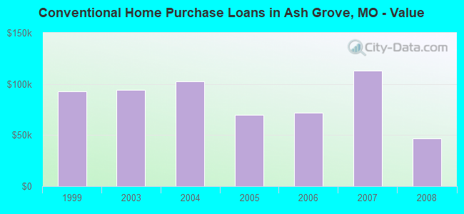
| Home Mortgage Disclosure Act Aggregated Statistics For Year 2009 (Based on 1 partial tract) | ||
| C) Refinancings | ||
|---|---|---|
| Number | Average Value | |
| LOANS ORIGINATED | 1 | $174,200 |
| APPLICATIONS APPROVED, NOT ACCEPTED | 0 | $0 |
| APPLICATIONS DENIED | 1 | $70,360 |
| APPLICATIONS WITHDRAWN | 1 | $75,850 |
| FILES CLOSED FOR INCOMPLETENESS | 0 | $0 |
Detailed HMDA statistics for the following Tracts: 0050.01
| Private Mortgage Insurance Companies Aggregated Statistics For Year 2003 (Based on 1 partial tract) | ||
| B) Refinancings | ||
|---|---|---|
| Number | Average Value | |
| LOANS ORIGINATED | 1 | $44,440 |
| APPLICATIONS APPROVED, NOT ACCEPTED | 0 | $0 |
| APPLICATIONS DENIED | 0 | $0 |
| APPLICATIONS WITHDRAWN | 0 | $0 |
| FILES CLOSED FOR INCOMPLETENESS | 0 | $0 |
Detailed PMIC statistics for the following Tracts: 0050.01
2002 - 2018 National Fire Incident Reporting System (NFIRS) incidents
- Fire incident types reported to NFIRS in Ash Grove, MO
- 11245.7%Structure Fires
- 10342.0%Outside Fires
- 156.1%Mobile Property/Vehicle Fires
- 156.1%Other
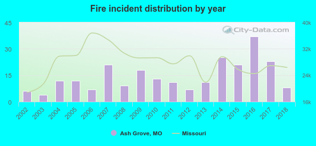 Based on the data from the years 2002 - 2018 the average number of fires per year is 14. The highest number of reported fires - 37 took place in 2016, and the least - 4 in 2003. The data has a growing trend.
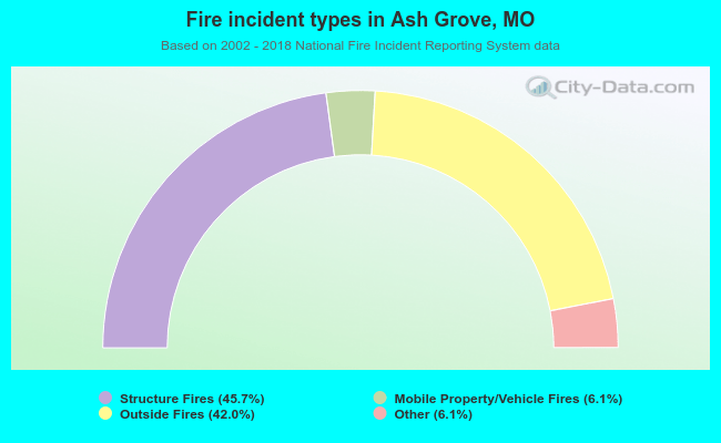 When looking into fire subcategories, the most incidents belonged to: Structure Fires (45.7%), and Outside Fires (42.0%).
| Most common first names in Ash Grove, MO among deceased individuals | ||
| Name | Count | Lived (average) |
|---|---|---|
| James | 33 | 77.6 years |
| William | 29 | 74.5 years |
| John | 21 | 76.0 years |
| Robert | 19 | 67.5 years |
| Mary | 16 | 84.4 years |
| Charles | 15 | 73.3 years |
| Ruth | 14 | 87.9 years |
| Helen | 14 | 77.8 years |
| Roy | 12 | 77.8 years |
| George | 10 | 83.6 years |
| Most common last names in Ash Grove, MO among deceased individuals | ||
| Last name | Count | Lived (average) |
|---|---|---|
| Johnson | 32 | 81.1 years |
| Brown | 14 | 71.4 years |
| Daniel | 14 | 82.0 years |
| Hawkins | 14 | 84.8 years |
| Stanton | 13 | 78.7 years |
| King | 12 | 78.7 years |
| West | 12 | 76.7 years |
| Claypool | 11 | 79.4 years |
| Wilson | 11 | 76.5 years |
| Murray | 10 | 82.7 years |
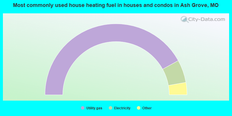
- 84.2%Utility gas
- 10.4%Electricity
- 2.9%Bottled, tank, or LP gas
- 1.5%Other fuel
- 1.0%Wood
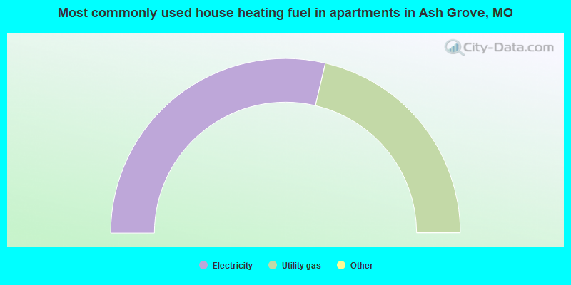
- 57.4%Electricity
- 42.6%Utility gas
Ash Grove compared to Missouri state average:
- Unemployed percentage significantly below state average.
- Black race population percentage significantly below state average.
- Hispanic race population percentage significantly below state average.
- Median age above state average.
- Foreign-born population percentage significantly below state average.
- Length of stay since moving in significantly below state average.
- House age significantly below state average.
- Institutionalized population percentage above state average.