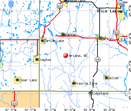
Arland, Wisconsin
Submit your own pictures of this town and show them to the world
- OSM Map
- General Map
- Google Map
- MSN Map
Population change since 2000: +17.8%
 |
| Males: 400 | |
| Females: 389 |
| Median resident age: | 35.3 years |
| Wisconsin median age: | 42.6 years |
Zip codes: 54812.
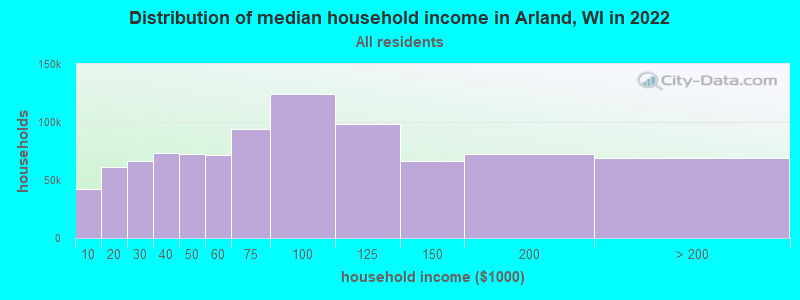
| Arland: | $49,924 |
| WI: | $70,996 |
Estimated per capita income in 2022: $25,621 (it was $13,555 in 2000)
Arland town income, earnings, and wages data
Estimated median house or condo value in 2022: $171,808 (it was $68,900 in 2000)
| Arland: | $171,808 |
| WI: | $252,800 |
Detailed information about poverty and poor residents in Arland, WI
Compare current foreclosures near Arland, WI:
| Photo | Address | Area | Beds / Baths | Price | Details |
|---|---|---|---|---|---|

|
#1
120th Ave
Turtle Lake, WI 54889
|
1,408 sq. feet
|
2 baths 2 beds |
show details | |

|
#2
W Euclid Ave
Barron, WI 54812
|
- sq. feet
|
1 baths 3 beds |
show details | |

|
#3
12 1/4 St
Prairie Farm, WI 54762
|
- sq. feet
|
- baths - beds |
show details | |

|
#4
E Allen St
Rice Lake, WI 54868
|
- sq. feet
|
- baths - beds |
show details | |

|
#5
1270th Ave
Glenwood City, WI 54013
|
- sq. feet
|
- baths - beds |
show details | |

|
#6
2nd Ave NW Apt 12
Clear Lake, WI 54005
|
- sq. feet
|
- baths - beds |
show details | |

|
#7
11th St
Prairie Farm, WI 54762
|
- sq. feet
|
- baths - beds |
show details | |

|
#8
Sunnyside Ave, Trlr 19
Cameron, WI 54822
|
- sq. feet
|
- baths - beds |
show details | |

|
#9
50th St
Clear Lake, WI 54005
|
- sq. feet
|
- baths - beds |
show details | |

|
#10
21 1/2 St
Rice Lake, WI 54868
|
- sq. feet
|
- baths - beds |
show details |
| Photo | Address | Area | Beds / Baths | Price | Details |
|---|---|---|---|---|---|

|
#11
S Main St
Rice Lake, WI 54868
|
- sq. feet
|
- baths - beds |
show details | |

|
#12
8th St
Chetek, WI 54728
|
- sq. feet
|
- baths - beds |
show details | |

|
#13
15 1/2 Ave
Turtle Lake, WI 54889
|
- sq. feet
|
- baths - beds |
show details | |

|
#14
5 1/4 St
Prairie Farm, WI 54762
|
- sq. feet
|
- baths - beds |
show details | |

|
#15
W Marshall St
Rice Lake, WI 54868
|
- sq. feet
|
- baths - beds |
show details | |

|
#16
Nunn Ave Apt 8
Rice Lake, WI 54868
|
- sq. feet
|
- baths - beds |
show details | |

|
#17
Whispering Pines St
Prairie Farm, WI 54762
|
- sq. feet
|
- baths - beds |
show details | |

|
#18
Clinton St S
Almena, WI 54805
|
- sq. feet
|
- baths - beds |
show details | |

|
#19
Portland Ave E Apt 203
Almena, WI 54805
|
- sq. feet
|
- baths - beds |
show details | |

|
#20
Kallenbach Dr
Almena, WI 54805
|
- sq. feet
|
- baths - beds |
show details |
| Photo | Address | Area | Beds / Baths | Price | Details |
|---|---|---|---|---|---|

|
#21
24 5/8 St
Chetek, WI 54728
|
- sq. feet
|
- baths - beds |
show details | |

|
#22
N Main St
Rice Lake, WI 54868
|
- sq. feet
|
- baths - beds |
show details | |

|
#23
8th Ave
Clear Lake, WI 54005
|
- sq. feet
|
- baths - beds |
show details | |

|
#24
W Marshall St
Rice Lake, WI 54868
|
- sq. feet
|
- baths - beds |
show details | |

|
#25
County Highway Ss
Chetek, WI 54728
|
- sq. feet
|
- baths - beds |
show details | |

|
#26
S Main St # 209
Rice Lake, WI 54868
|
- sq. feet
|
- baths - beds |
show details | |

|
#27
55th St
Amery, WI 54001
|
- sq. feet
|
- baths - beds |
show details | |

|
#28
19 3/4 St
Rice Lake, WI 54868
|
- sq. feet
|
- baths - beds |
show details | |

|
#29
Comstock Ave
Cumberland, WI 54829
|
- sq. feet
|
- baths - beds |
show details | |

|
#30
19 3/8 St
Cameron, WI 54822
|
- sq. feet
|
- baths - beds |
show details |
| Photo | Address | Area | Beds / Baths | Price | Details |
|---|---|---|---|---|---|

|
#31
120th Ave
Turtle Lake, WI 54889
|
- sq. feet
|
- baths - beds |
show details | |

|
#32
16 3/4 Ave
Turtle Lake, WI 54889
|
- sq. feet
|
- baths - beds |
show details | |

|
#33
115th Ave
Turtle Lake, WI 54889
|
- sq. feet
|
- baths - beds |
show details | |

|
#34
County Line St
Clayton, WI 54004
|
- sq. feet
|
- baths - beds |
show details | |

|
#35
E Division Ave
Barron, WI 54812
|
- sq. feet
|
- baths - beds |
show details | |

|
#36
E River Ave
Barron, WI 54812
|
- sq. feet
|
- baths - beds |
show details | |

|
#37
W La Salle Ave
Barron, WI 54812
|
- sq. feet
|
- baths - beds |
show details | |

|
#38
Rose Ave
Rice Lake, WI 54868
|
- sq. feet
|
- baths - beds |
show details | |

|
Check over 1 million property listings on Foreclosure.com!
|
browse all offers | |||

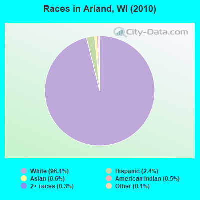
- 75896.1%White alone
- 192.4%Hispanic
- 50.6%Asian alone
- 40.5%American Indian alone
- 20.3%Two or more races
- 10.1%Other race alone
Races in Arland detailed stats: ancestries, foreign born residents, place of birth
 Recent articles from our blog. Our writers, many of them Ph.D. graduates or candidates, create easy-to-read articles on a wide variety of topics.

Latest news from Arland, WI collected exclusively by city-data.com from local newspapers, TV, and radio stations
Ancestries: German (43.0%), Norwegian (33.3%), Irish (12.1%), United States (5.8%), Swedish (4.8%), French (4.3%).
Current Local Time: CST time zone
Elevation: 1217 feet
Land area: 35.3 square miles.
Population density: 22 people per square mile (very low).
3 residents are foreign born
| This town: | 0.4% |
| Wisconsin: | 3.6% |
| Arland town: | 1.1% ($750) |
| Wisconsin: | 2.0% ($2,245) |
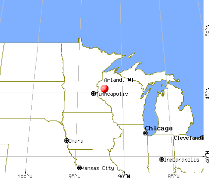
Nearest city with pop. 50,000+: Eau Claire, WI  (42.7 miles , pop. 61,704).
Nearest city with pop. 200,000+: St. Paul, MN (61.7 miles , pop. 287,151).
Nearest city with pop. 1,000,000+: Chicago, IL (323.2 miles , pop. 2,896,016).
Nearest cities:
), ), ), Latitude: 45.33 N, Longitude: 91.97 W
Area code commonly used in this area: 715

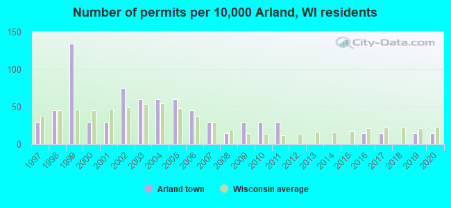
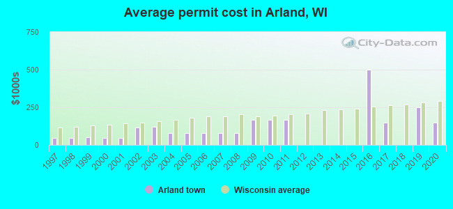
Single-family new house construction building permits:
- 2020: 1 building, cost: $150,000
- 2019: 1 building, cost: $250,000
- 2017: 1 building, cost: $150,000
- 2016: 1 building, cost: $500,000
- 2011: 2 buildings, average cost: $168,100
- 2010: 2 buildings, average cost: $168,100
- 2009: 2 buildings, average cost: $168,100
- 2008: 1 building, cost: $81,300
- 2007: 2 buildings, average cost: $81,300
- 2006: 3 buildings, average cost: $81,300
- 2005: 4 buildings, average cost: $81,300
- 2004: 4 buildings, average cost: $81,300
- 2003: 4 buildings, average cost: $120,000
- 2002: 5 buildings, average cost: $118,000
- 2001: 2 buildings, average cost: $45,000
- 2000: 2 buildings, average cost: $45,000
- 1999: 9 buildings, average cost: $50,300
- 1998: 3 buildings, average cost: $44,000
- 1997: 2 buildings, average cost: $44,000
| Here: | 3.4% |
| Wisconsin: | 2.7% |
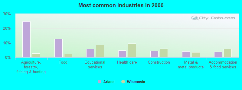
- Agriculture, forestry, fishing & hunting (24.9%)
- Food (12.8%)
- Educational services (5.9%)
- Health care (4.7%)
- Construction (4.5%)
- Metal & metal products (4.2%)
- Accommodation & food services (3.9%)
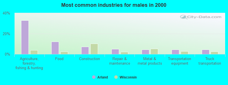
- Agriculture, forestry, fishing & hunting (32.9%)
- Food (12.1%)
- Construction (7.2%)
- Repair & maintenance (4.8%)
- Metal & metal products (4.3%)
- Transportation equipment (4.3%)
- Truck transportation (4.3%)
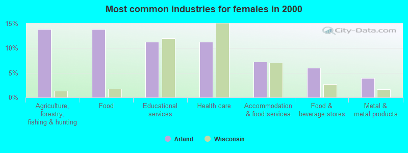
- Agriculture, forestry, fishing & hunting (13.9%)
- Food (13.9%)
- Educational services (11.3%)
- Health care (11.3%)
- Accommodation & food services (7.3%)
- Food & beverage stores (6.0%)
- Metal & metal products (4.0%)
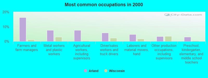
- Farmers and farm managers (16.2%)
- Metal workers and plastic workers (7.5%)
- Agricultural workers, including supervisors (7.5%)
- Driver/sales workers and truck drivers (5.9%)
- Laborers and material movers, hand (4.7%)
- Other production occupations, including supervisors (3.4%)
- Preschool, kindergarten, elementary, and middle school teachers (3.1%)
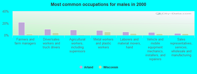
- Farmers and farm managers (21.7%)
- Driver/sales workers and truck drivers (10.1%)
- Agricultural workers, including supervisors (9.2%)
- Metal workers and plastic workers (8.2%)
- Laborers and material movers, hand (5.8%)
- Vehicle and mobile equipment mechanics, installers, and repairers (4.8%)
- Sales representatives, services, wholesale and manufacturing (3.4%)
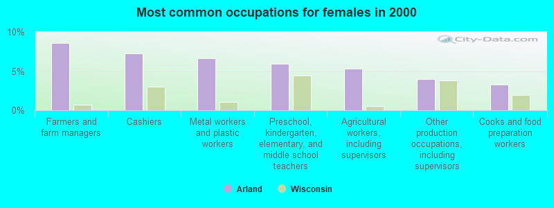
- Farmers and farm managers (8.6%)
- Cashiers (7.3%)
- Metal workers and plastic workers (6.6%)
- Preschool, kindergarten, elementary, and middle school teachers (6.0%)
- Agricultural workers, including supervisors (5.3%)
- Other production occupations, including supervisors (4.0%)
- Cooks and food preparation workers (3.3%)
Average climate in Arland, Wisconsin
Based on data reported by over 4,000 weather stations


Tornado activity:
Arland-area historical tornado activity is slightly below Wisconsin state average. It is 1% smaller than the overall U.S. average.
On 6/4/1958, a category F5 (max. wind speeds 261-318 mph) tornado 24.4 miles away from the Arland town center killed 21 people and injured 74 people and caused between $5,000,000 and $50,000,000 in damages.
On 7/30/1977, a category F4 (max. wind speeds 207-260 mph) tornado 26.7 miles away from the town center injured 20 people and caused between $5,000,000 and $50,000,000 in damages.
Earthquake activity:
Arland-area historical earthquake activity is significantly above Wisconsin state average. It is 66% smaller than the overall U.S. average.On 7/9/1975 at 14:54:15, a magnitude 4.6 (4.6 MB, Class: Light, Intensity: IV - V) earthquake occurred 198.8 miles away from Arland center
On 6/5/1993 at 01:24:53, a magnitude 4.1 (4.1 LG, Depth: 6.2 mi) earthquake occurred 211.0 miles away from the city center
On 3/4/1983 at 06:32:18, a magnitude 4.6 (4.4 MB, 4.6 LG, 4.4 ML) earthquake occurred 373.3 miles away from the city center
On 6/28/2004 at 06:10:52, a magnitude 4.2 (4.2 MW, Depth: 6.2 mi) earthquake occurred 309.0 miles away from Arland center
On 2/7/2020 at 18:30:28, a magnitude 3.3 (3.3 ML, Class: Light, Intensity: II - III) earthquake occurred 152.8 miles away from Arland center
On 1/9/2020 at 18:16:48, a magnitude 3.3 (3.3 MB) earthquake occurred 156.9 miles away from the city center
Magnitude types: regional Lg-wave magnitude (LG), body-wave magnitude (MB), local magnitude (ML), moment magnitude (MW)
Natural disasters:
The number of natural disasters in Barron County (9) is smaller than the US average (15).Major Disasters (Presidential) Declared: 5
Emergencies Declared: 3
Causes of natural disasters: Floods: 5, Storms: 4, Tornadoes: 4, Winds: 2, Drought: 1, Hurricane: 1, Other: 1 (Note: some incidents may be assigned to more than one category).

Hospitals and medical centers near Arland:
- PIONEER NURSING HOME (Nursing Home, about 7 miles away; PRAIRIE FARM, WI)
- MAYO DIALYSIS - BARRON (Dialysis Facility, about 8 miles away; BARRON, WI)
- MAYO CLINIC HEALTH SYSTEM - NORTHLAND, INC Critical Access Hospitals (about 8 miles away; BARRON, WI)
- BARRON CARE AND REHAB (Nursing Home, about 8 miles away; BARRON, WI)
- DALLAS CARE AND REHAB (Nursing Home, about 10 miles away; DALLAS, WI)
- CUMBERLAND MEMORIAL HOSPITAL Critical Access Hospitals (about 15 miles away; CUMBERLAND, WI)
- CUMBERLAND MEM HSPTL ECU (Nursing Home, about 15 miles away; CUMBERLAND, WI)
Colleges/universities with over 2000 students nearest to Arland:
- Wisconsin Indianhead Technical College (about 29 miles; Shell Lake, WI; Full-time enrollment: 2,414)
- University of Wisconsin-Stout (about 31 miles; Menomonie, WI; FT enrollment: 8,120)
- University of Wisconsin-Eau Claire (about 44 miles; Eau Claire, WI; FT enrollment: 10,143)
- Chippewa Valley Technical College (about 44 miles; Eau Claire, WI; FT enrollment: 4,038)
- University of Wisconsin-River Falls (about 47 miles; River Falls, WI; FT enrollment: 5,868)
- Century College (about 54 miles; White Bear Lake, MN; FT enrollment: 7,393)
- Metropolitan State University (about 60 miles; Saint Paul, MN; FT enrollment: 6,159)
Points of interest:
Notable locations in Arland: Degerman Daries (A), Arland Townhall (B). Display/hide their locations on the map
Churches in Arland include: Bethany Church (A), Lutheran Church (B). Display/hide their locations on the map
Cemetery: Independent Cemetery (1). Display/hide its location on the map
Reservoir: 0.05 Reservoir (A). Display/hide its location on the map
Creek: Tainter Creek (A). Display/hide its location on the map
Park in Arland: Thompson Park (1). Display/hide its location on the map
| This town: | 2.9 people |
| Wisconsin: | 2.4 people |
| This town: | 76.0% |
| Whole state: | 64.4% |
| This town: | 7.7% |
| Whole state: | 7.3% |
Likely homosexual households (counted as self-reported same-sex unmarried-partner households)
- Lesbian couples: 0.0% of all households
- Gay men: 0.7% of all households
| This town: | 12.2% |
| Whole state: | 8.7% |
| This town: | 6.4% |
| Whole state: | 3.7% |
For population 15 years and over in Arland:
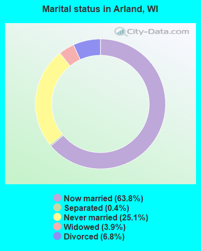
- Never married: 25.1%
- Now married: 63.8%
- Separated: 0.4%
- Widowed: 3.9%
- Divorced: 6.8%
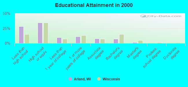
For population 25 years and over in Arland:
- High school or higher: 71.7%
- Bachelor's degree or higher: 8.8%
- Graduate or professional degree: 1.6%
- Unemployed: 6.8%
- Mean travel time to work (commute): 20.6 minutes
| Here: | 11.4 |
| Wisconsin average: | 11.0 |
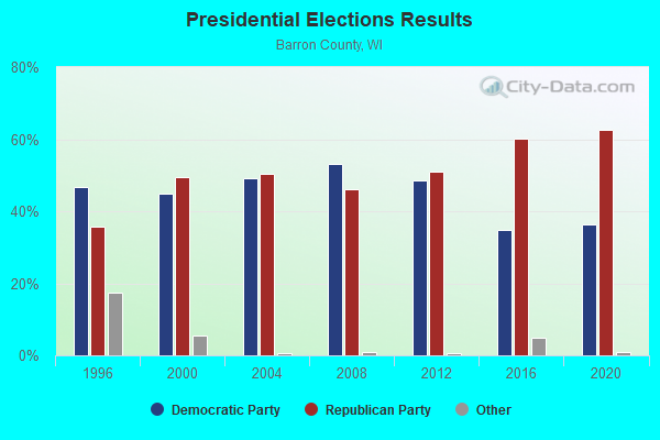
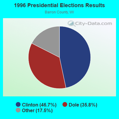
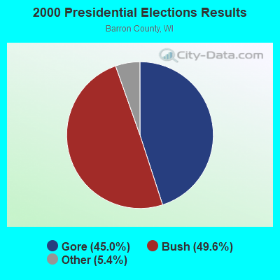
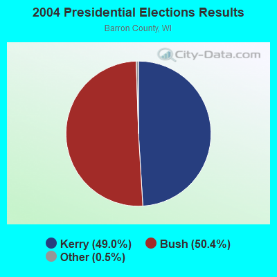
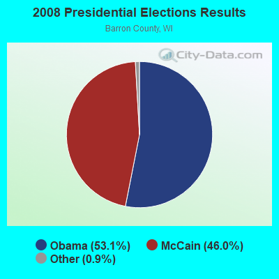
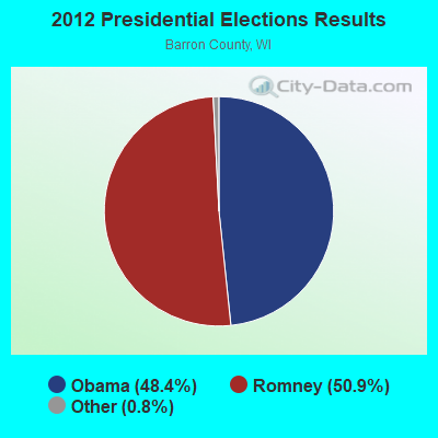
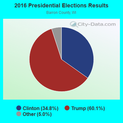
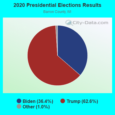
Graphs represent county-level data. Detailed 2008 Election Results
Religion statistics for Arland, WI (based on Barron County data)
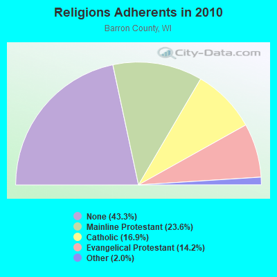
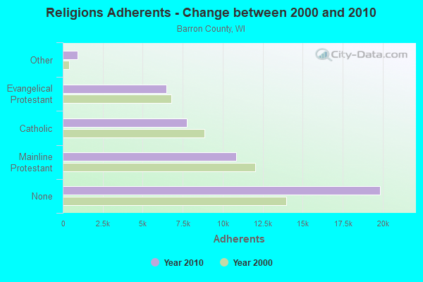
| Religion | Adherents | Congregations |
|---|---|---|
| Mainline Protestant | 10,839 | 26 |
| Catholic | 7,764 | 8 |
| Evangelical Protestant | 6,492 | 42 |
| Other | 919 | 5 |
| Orthodox | - | - |
| None | 19,856 | - |
Food Environment Statistics:
| This county: | 1.76 / 10,000 pop. |
| State: | 1.86 / 10,000 pop. |
| Barron County: | 5.71 / 10,000 pop. |
| State: | 4.12 / 10,000 pop. |
| This county: | 9.88 / 10,000 pop. |
| State: | 8.64 / 10,000 pop. |
| Barron County: | 8.5% |
| State: | 7.6% |
| Barron County: | 28.2% |
| State: | 27.5% |
| Barron County: | 14.1% |
| Wisconsin: | 13.0% |
Strongest AM radio stations in Arland:
- WCTS (1030 AM; 50 kW; MAPLEWOOD, MN; Owner: CNTL. BAPT. THEO/AL SEMI MINNEAPOLIS)
- WAQE (1090 AM; daytime; 5 kW; RICE LAKE, WI; Owner: TKC, INC.)
- WCCO (830 AM; 50 kW; MINNEAPOLIS, MN; Owner: INFINITY MEDIA CORPORATION)
- KSTP (1500 AM; 50 kW; ST. PAUL, MN; Owner: KSTP-AM, LLC (DELAWARE))
- WEBC (560 AM; 50 kW; DULUTH, MN)
- WXCE (1260 AM; 5 kW; AMERY, WI; Owner: LAKE COUNTRY BROADCASTING CORPORATION)
- WMEQ (880 AM; 10 kW; MENOMONIE, WI; Owner: CAPSTAR TX LIMITED PARTNERSHIP)
- KTIS (900 AM; 25 kW; MINNEAPOLIS, MN; Owner: NORTHWESTERN COLLEGE)
- WDGY (630 AM; 8 kW; HUDSON, WI; Owner: 630 RADIO, INCORPORATED)
- KFAN (1130 AM; 50 kW; MINNEAPOLIS, MN; Owner: AMFM RADIO LICENSES, L.L.C.)
- WJMC (1240 AM; 1 kW; RICE LAKE, WI; Owner: TKC, INC.)
- WAYY (790 AM; 5 kW; EAU CLAIRE, WI; Owner: MAVERICK MEDIA OF EAU CLAIRE LICENSE LLC)
- WSPT (1010 AM; 50 kW; STEVENS POINT, WI)
Strongest FM radio stations in Arland:
- WHWC (88.3 FM; MENOMONIE, WI; Owner: STATE OF WISCONSIN - EDUCATIONAL COMMUNICATIONS BOARD)
- WATQ (106.7 FM; CHETEK, WI; Owner: CAPSTAR TX LIMITED PARTNERSHIP)
- WJMC-FM (96.1 FM; RICE LAKE, WI; Owner: TKC, INC.)
- WKFX (97.7 FM; RICE LAKE, WI; Owner: TKC, INC.)
- WMEQ-FM (92.1 FM; MENOMONIE, WI; Owner: CAPSTAR TX LIMITED PARTNERSHIP)
- WAQE-FM (97.7 FM; BARRON, WI; Owner: TKC, INC.)
- WLMX-FM (104.9 FM; BALSAM LAKE, WI; Owner: QUARNSTROM MEDIA GROUP, LLC)
- WXPT (104.1 FM; ST. LOUIS PARK, MN; Owner: THE AUDIO HOUSE, INC.)
- WGMO (95.3 FM; SHELL LAKE, WI; Owner: ZOE COMMUNICATIONS, INC.)
- WWIB (103.7 FM; HALLIE, WI; Owner: STEWARDS OF SOUND, INC.)
- WVSS (90.7 FM; MENOMONIE, WI; Owner: BD. OF REGENTS, UNIVERSITY OF WISCONSIN SYSTEM)
TV broadcast stations around Arland:
- WHWC-TV (Channel 28; MENOMONIE, WI; Owner: STATE OF WISCONSIN - EDUCATIONAL COMMUNICATIONS BOARD)
- WEUX (Channel 48; CHIPPEWA FALLS, WI; Owner: GRANT MEDIA INC.)
- National Bridge Inventory (NBI) Statistics
- 16Number of bridges
- 75ft / 23.0mTotal length
- $271,000Total costs
- 5,490Total average daily traffic
- 6Total average daily truck traffic
- 6,031Total future (year 2039) average daily traffic
- New bridges - historical statistics
- 11920-1929
- 11940-1949
- 11950-1959
- 11960-1969
- 21970-1979
- 41980-1989
- 41990-1999
- 22000-2009
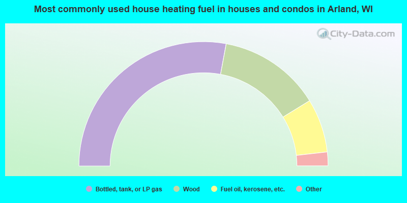
- 55.9%Bottled, tank, or LP gas
- 26.6%Wood
- 14.0%Fuel oil, kerosene, etc.
- 2.3%Utility gas
- 1.4%Electricity
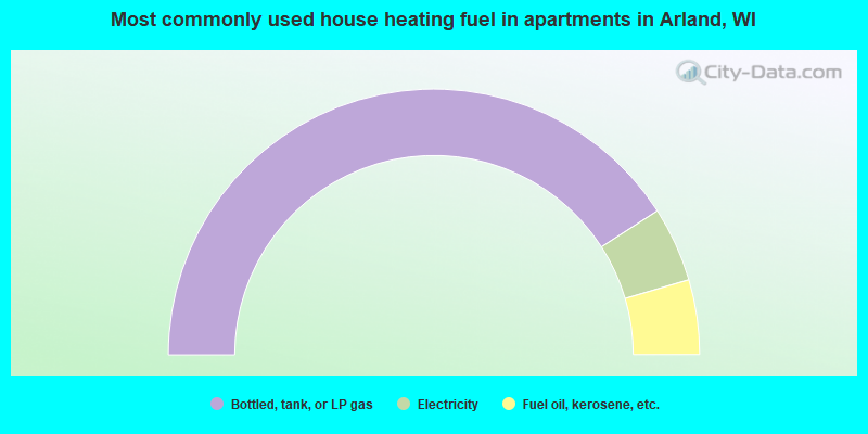
- 81.8%Bottled, tank, or LP gas
- 9.1%Electricity
- 9.1%Fuel oil, kerosene, etc.
Arland compared to Wisconsin state average:
- Unemployed percentage below state average.
- Black race population percentage significantly below state average.
- Hispanic race population percentage below state average.
- Median age below state average.
- Foreign-born population percentage significantly below state average.
- Renting percentage significantly below state average.
- Length of stay since moving in significantly above state average.
- Number of rooms per house significantly below state average.
- House age significantly below state average.
- Number of college students below state average.
- Percentage of population with a bachelor's degree or higher significantly below state average.