Andover, New Hampshire
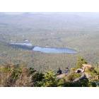
Submit your own pictures of this town and show them to the world
- OSM Map
- General Map
- Google Map
- MSN Map
Population change since 2000: +12.4%
 |
| Males: 1,210 | |
| Females: 1,161 |
| Median resident age: | 41.4 years |
| New Hampshire median age: | 43.9 years |
Zip codes: 03216.
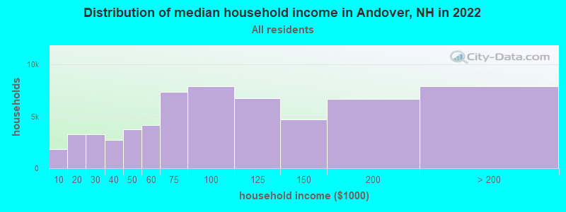
| Andover: | $82,196 |
| NH: | $89,992 |
Estimated per capita income in 2022: $43,321 (it was $21,627 in 2000)
Andover town income, earnings, and wages data
Estimated median house or condo value in 2022: $330,470 (it was $105,600 in 2000)
| Andover: | $330,470 |
| NH: | $384,700 |
Mean prices in 2022: all housing units: $378,901; detached houses: $416,256; townhouses or other attached units: $317,750; in 2-unit structures: $298,869; in 3-to-4-unit structures: $371,619; in 5-or-more-unit structures: $216,601; mobile homes: $110,180; occupied boats, rvs, vans, etc.: $74,347
Detailed information about poverty and poor residents in Andover, NH


- 2,27596.0%White alone
- 331.4%Two or more races
- 210.9%Asian alone
- 210.9%Hispanic
- 110.5%Black alone
- 100.4%American Indian alone
Races in Andover detailed stats: ancestries, foreign born residents, place of birth
According to our research of New Hampshire and other state lists, there were 6 registered sex offenders living in Andover, New Hampshire as of May 17, 2024.
The ratio of all residents to sex offenders in Andover is 395 to 1.
Full-time law enforcement employees in 2021, including police officers: 2 (2 officers - 2 male; 0 female).
| Officers per 1,000 residents here: | 0.84 |
| New Hampshire average: | 2.14 |
 Recent articles from our blog. Our writers, many of them Ph.D. graduates or candidates, create easy-to-read articles on a wide variety of topics.

 | Tell me about Andover, NH (1 reply) |
| Moving to southeast NH, looking for suggestions (22 replies) |
| Potential job in Andover, MA- Need help (46 replies) |
| Pros and cons of Shifting to New Hampshire from Massachusetts (21 replies) |
| Moving to NH: Tips for narrowing town search (15 replies) |
| Commute Concord or Manchester NH to Andover MA (5 replies) |
Latest news from Andover, NH collected exclusively by city-data.com from local newspapers, TV, and radio stations
Ancestries: English (23.6%), Irish (14.7%), French (12.8%), United States (10.1%), German (9.2%), French Canadian (8.0%).
Current Local Time: EST time zone
Incorporated in 1779
Elevation: 648 feet
Land area: 40.5 square miles.
Population density: 59 people per square mile (very low).
47 residents are foreign born (1.1% Europe, 0.4% Latin America, 0.4% North America).
| This town: | 2.2% |
| New Hampshire: | 4.4% |
| Andover town: | 1.7% ($1,745) |
| New Hampshire: | 2.3% ($2,946) |
Nearest city with pop. 50,000+: Manchester, NH  (35.9 miles , pop. 107,006).
Nearest city with pop. 200,000+: Boston, MA (85.3 miles , pop. 589,141).
Nearest city with pop. 1,000,000+: Bronx, NY (209.2 miles , pop. 1,332,650).
Nearest cities:
), ), ), Latitude: 43.44 N, Longitude: 71.78 W
Area code: 603

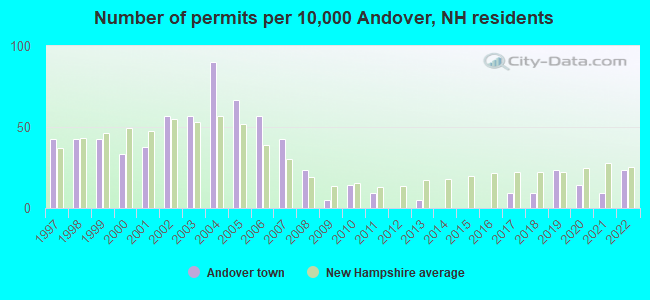
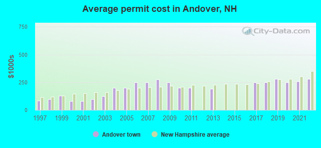
Single-family new house construction building permits:
- 2022: 5 buildings, average cost: $279,200
- 2021: 2 buildings, average cost: $259,200
- 2020: 3 buildings, average cost: $248,200
- 2019: 5 buildings, average cost: $282,200
- 2018: 2 buildings, average cost: $249,800
- 2017: 2 buildings, average cost: $248,100
- 2013: 1 building, cost: $193,300
- 2011: 2 buildings, average cost: $200,000
- 2010: 3 buildings, average cost: $200,000
- 2009: 1 building, cost: $250,000
- 2008: 5 buildings, average cost: $274,000
- 2007: 9 buildings, average cost: $250,000
- 2006: 12 buildings, average cost: $250,000
- 2005: 14 buildings, average cost: $200,000
- 2004: 19 buildings, average cost: $200,000
- 2003: 12 buildings, average cost: $125,000
- 2002: 12 buildings, average cost: $100,000
- 2001: 8 buildings, average cost: $80,000
- 2000: 7 buildings, average cost: $80,000
- 1999: 9 buildings, average cost: $130,600
- 1998: 9 buildings, average cost: $100,000
- 1997: 9 buildings, average cost: $83,300
| Here: | 2.1% |
| New Hampshire: | 2.5% |

- Educational services (14.3%)
- Construction (10.6%)
- Health care (9.6%)
- Metal & metal products (6.3%)
- Public administration (5.3%)
- Accommodation & food services (5.0%)
- Finance & insurance (4.5%)
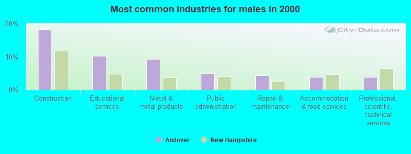
- Construction (18.3%)
- Educational services (10.2%)
- Metal & metal products (9.3%)
- Public administration (5.0%)
- Repair & maintenance (4.3%)
- Accommodation & food services (3.8%)
- Professional, scientific, technical services (3.8%)
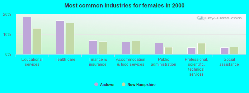
- Educational services (18.7%)
- Health care (16.9%)
- Finance & insurance (7.0%)
- Accommodation & food services (6.2%)
- Public administration (5.7%)
- Professional, scientific, technical services (3.4%)
- Social assistance (3.4%)
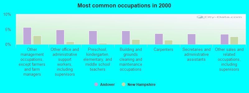
- Other management occupations, except farmers and farm managers (5.7%)
- Other office and administrative support workers, including supervisors (4.8%)
- Preschool, kindergarten, elementary, and middle school teachers (4.6%)
- Building and grounds cleaning and maintenance occupations (4.6%)
- Carpenters (3.6%)
- Secretaries and administrative assistants (3.5%)
- Other sales and related occupations, including supervisors (3.4%)
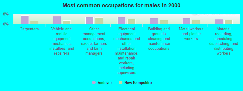
- Carpenters (6.7%)
- Vehicle and mobile equipment mechanics, installers, and repairers (6.3%)
- Other management occupations, except farmers and farm managers (5.7%)
- Electrical equipment mechanics and other installation, maintenance, and repair workers, including supervisors (5.7%)
- Building and grounds cleaning and maintenance occupations (4.8%)
- Metal workers and plastic workers (4.8%)
- Material recording, scheduling, dispatching, and distributing workers (3.8%)
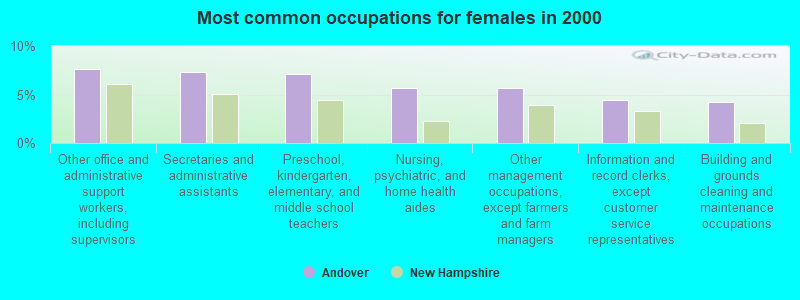
- Other office and administrative support workers, including supervisors (7.7%)
- Secretaries and administrative assistants (7.3%)
- Preschool, kindergarten, elementary, and middle school teachers (7.1%)
- Nursing, psychiatric, and home health aides (5.7%)
- Other management occupations, except farmers and farm managers (5.7%)
- Information and record clerks, except customer service representatives (4.5%)
- Building and grounds cleaning and maintenance occupations (4.3%)
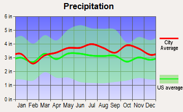
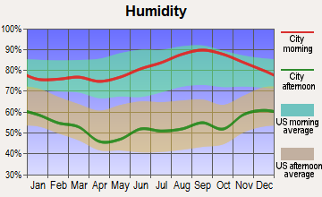
Average climate in Andover, New Hampshire
Based on data reported by over 4,000 weather stations


(lower is better)
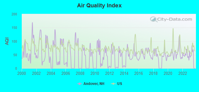
Air Quality Index (AQI) level in 2022 was 51.1. This is significantly better than average.
| City: | 51.1 |
| U.S.: | 72.6 |
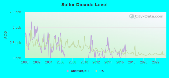
Sulfur Dioxide (SO2) [ppb] level in 2016 was 1.05. This is significantly better than average. Closest monitor was 20.6 miles away from the city center.
| City: | 1.05 |
| U.S.: | 1.51 |
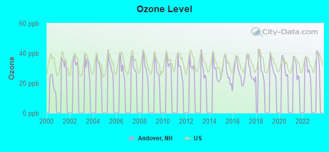
Ozone [ppb] level in 2022 was 29.5. This is about average. Closest monitor was 16.7 miles away from the city center.
| City: | 29.5 |
| U.S.: | 33.3 |
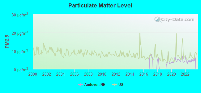
Particulate Matter (PM2.5) [µg/m3] level in 2022 was 4.52. This is significantly better than average. Closest monitor was 16.4 miles away from the city center.
| City: | 4.52 |
| U.S.: | 8.11 |
Tornado activity:
Andover-area historical tornado activity is near New Hampshire state average. It is 54% smaller than the overall U.S. average.
On 5/11/1973, a category F2 (max. wind speeds 113-157 mph) tornado 12.0 miles away from the Andover town center .
On 7/3/1972, a category F2 tornado 17.9 miles away from the town center injured 7 people and caused between $5000 and $50,000 in damages.
Earthquake activity:
Andover-area historical earthquake activity is significantly above New Hampshire state average. It is 71% smaller than the overall U.S. average.On 4/20/2002 at 10:50:47, a magnitude 5.3 (5.3 ML, Depth: 3.0 mi, Class: Moderate, Intensity: VI - VII) earthquake occurred 120.5 miles away from the city center
On 10/7/1983 at 10:18:46, a magnitude 5.3 (5.1 MB, 5.3 LG, 5.1 ML) earthquake occurred 132.7 miles away from Andover center
On 1/19/1982 at 00:14:42, a magnitude 4.7 (4.5 MB, 4.7 MD, 4.5 LG, Class: Light, Intensity: IV - V) earthquake occurred 10.0 miles away from the city center
On 4/20/2002 at 10:50:47, a magnitude 5.2 (5.2 MB, 4.2 MS, 5.2 MW, 5.0 MW) earthquake occurred 120.3 miles away from the city center
On 10/16/2012 at 23:12:25, a magnitude 4.7 (4.7 ML, Depth: 10.0 mi) earthquake occurred 57.6 miles away from Andover center
On 8/21/1996 at 07:54:14, a magnitude 3.8 (3.8 LG, 3.6 LG, Depth: 6.2 mi, Class: Light, Intensity: II - III) earthquake occurred 55.5 miles away from the city center
Magnitude types: regional Lg-wave magnitude (LG), body-wave magnitude (MB), duration magnitude (MD), local magnitude (ML), surface-wave magnitude (MS), moment magnitude (MW)
Natural disasters:
The number of natural disasters in Merrimack County (27) is a lot greater than the US average (15).Major Disasters (Presidential) Declared: 17
Emergencies Declared: 9
Causes of natural disasters: Storms: 13, Floods: 12, Winter Storms: 4, Snowstorms: 3, Hurricanes: 2, Snows: 2, Blizzard: 1, Ice Storm: 1, Snowfall: 1, Tornado: 1, Tropical Storm: 1, Wind: 1, Other: 1 (Note: some incidents may be assigned to more than one category).

Hospitals and medical centers near Andover:
- MERRILL MANOR ANNEX (Nursing Home, about 7 miles away; FRANKLIN, NH)
- MERRILL MANOR NURSING HOME (Nursing Home, about 7 miles away; FRANKLIN, NH)
- FRANKLIN REGIONAL HOSPITAL Critical Access Hospitals (about 8 miles away; FRANKLIN, NH)
- VNA OF FRANKLIN (Home Health Center, about 8 miles away; FRANKLIN, NH)
- MOUNTAIN RIDGE CENTER, GENESIS HEALTHCARE (Nursing Home, about 8 miles away; FRANKLIN, NH)
- MERRIMACK COUNTY NURSING HOME (Nursing Home, about 9 miles away; BOSCAWEN, NH)
- NEWFOUND AREA NURSING ASSN (Home Health Center, about 11 miles away; BRISTOL, NH)
Airports located in Andover:
- Tucker Farm Airport (94NH) (Runways: 1)
Colleges/universities with over 2000 students nearest to Andover:
- NHTI-Concord's Community College (about 20 miles; Concord, NH; Full-time enrollment: 2,865)
- Plymouth State University (about 23 miles; Plymouth, NH; FT enrollment: 4,838)
- Dartmouth College (about 32 miles; Hanover, NH; FT enrollment: 6,030)
- Southern New Hampshire University (about 33 miles; Manchester, NH; FT enrollment: 16,552)
- Saint Anselm College (about 35 miles; Manchester, NH; FT enrollment: 2,059)
- Mount Washington College (about 37 miles; Manchester, NH; FT enrollment: 2,187)
- Keene State College (about 44 miles; Keene, NH; FT enrollment: 5,098)
Private high school in Andover:
- PROCTOR ACADEMY (Students: 355, Location: 204 MAIN ST, Grades: 9-12)
Public elementary/middle school in Andover:
- ANDOVER ELEMENTARY SCHOOL (Students: 251, Location: 20 SCHOOL ST., Grades: KG-8)
Points of interest:
Notable locations in Andover: Childrens Camp (A), Ragged Mountain Club (B), East Andover Fire Department (C), Andover Fire Department (D), Andover Rescue Squad (E). Display/hide their locations on the map
Churches in Andover include: Immaculate Conception Church (A), Andover Congregational Church (B). Display/hide their locations on the map
Cemetery: Lakeside Cemetery (1). Display/hide its location on the map
Lakes and reservoirs: Adder Pond (A), Bog Pond (B), Cold Pond (C), Elbow Pond (D), Emory Pond (E), Horseshoe Pond (F), Huntoon Pond (G), Mud Pond (H). Display/hide their locations on the map
Streams, rivers, and creeks: Tilton Brook (A), Mitchell Brook (B), Hameshop Brook (C), Frazier Brook (D), Cascade Brook (E), Bradley Brook (F). Display/hide their locations on the map
Park in Andover: Mount Kearsarge State Wildlife Management Area (1). Display/hide its location on the map
Hotel: Potter Place Inn-Restaurant (88 Depot) (1). Display/hide its approximate location on the map
Drinking water stations with addresses in Andover and their reported violations in the past:
ANDOVER VILLAGE DIST (Population served: 650, Surface water):Past health violations:
- MCL, Monthly (TCR) - In JUN-2006, Contaminant: Coliform. Follow-up actions: St Public Notif requested (JUN-27-2006), St Violation/Reminder Notice (JUN-27-2006), St Public Notif received (JUL-24-2006), St Compliance achieved (DEC-28-2006)
| This town: | 2.5 people |
| New Hampshire: | 2.5 people |
| This town: | 70.7% |
| Whole state: | 66.3% |
| This town: | 7.8% |
| Whole state: | 8.3% |
Likely homosexual households (counted as self-reported same-sex unmarried-partner households)
- Lesbian couples: 0.6% of all households
- Gay men: 0.4% of all households
| This town: | 5.7% |
| Whole state: | 6.5% |
| This town: | 2.7% |
| Whole state: | 2.8% |
12 people in group homes intended for adults in 2010
14 people in other noninstitutional group quarters in 2000
Banks with branches in Andover (2011 data):
- Lake Sunapee Bank, FSB: Andover Branch at 7 Lawrence Street, branch established on 1999/10/29. Info updated 2011/07/21: Bank assets: $1,040.6 mil, Deposits: $808.6 mil, headquarters in Newport, NH, positive income, Mortgage Lending Specialization, 27 total offices
For population 15 years and over in Andover:
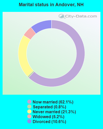
- Never married: 21.3%
- Now married: 62.1%
- Separated: 0.8%
- Widowed: 5.2%
- Divorced: 10.6%
For population 25 years and over in Andover:
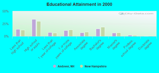
- High school or higher: 85.8%
- Bachelor's degree or higher: 25.0%
- Graduate or professional degree: 9.9%
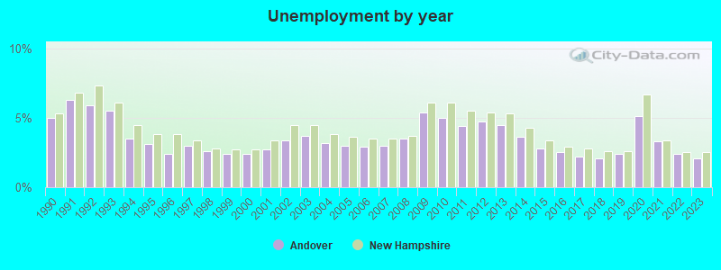
- Unemployed: 3.8%
- Mean travel time to work (commute): 25.7 minutes
| Here: | 11.5 |
| New Hampshire average: | 10.9 |
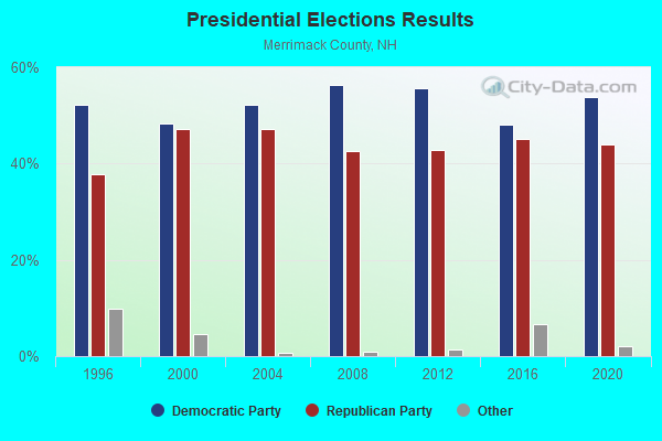
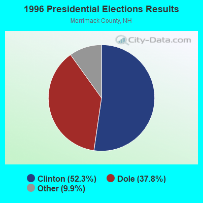
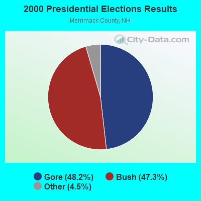
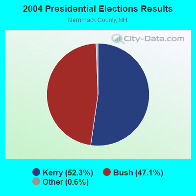

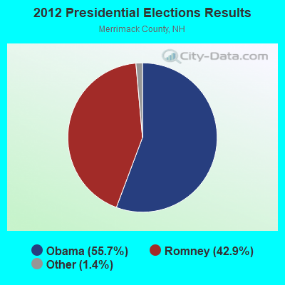
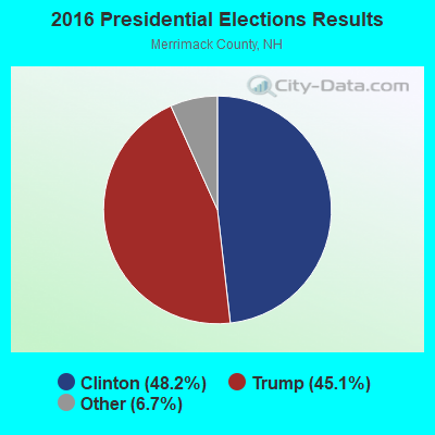
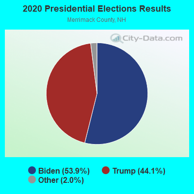
Graphs represent county-level data. Detailed 2008 Election Results
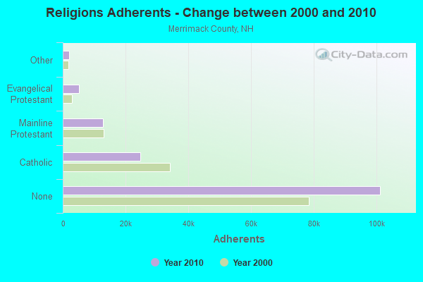
Religion statistics for Andover, NH (based on Merrimack County data)
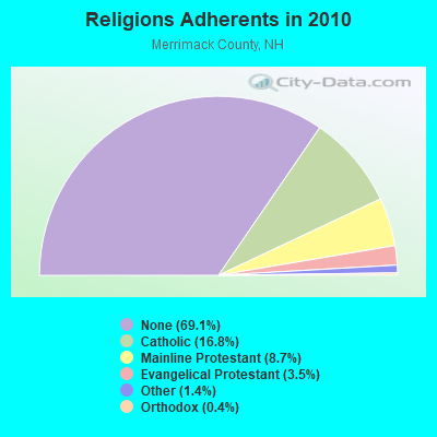
| Religion | Adherents | Congregations |
|---|---|---|
| Catholic | 24,654 | 7 |
| Mainline Protestant | 12,791 | 51 |
| Evangelical Protestant | 5,195 | 36 |
| Other | 2,097 | 15 |
| Orthodox | 580 | 2 |
| None | 101,128 | - |
Food Environment Statistics:
| Merrimack County: | 1.82 / 10,000 pop. |
| New Hampshire: | 2.14 / 10,000 pop. |
| This county: | 0.14 / 10,000 pop. |
| State: | 0.15 / 10,000 pop. |
| Merrimack County: | 1.22 / 10,000 pop. |
| New Hampshire: | 1.78 / 10,000 pop. |
| Merrimack County: | 4.39 / 10,000 pop. |
| State: | 4.02 / 10,000 pop. |
| Here: | 7.77 / 10,000 pop. |
| State: | 9.70 / 10,000 pop. |
| This county: | 7.4% |
| New Hampshire: | 7.6% |
| Merrimack County: | 23.8% |
| New Hampshire: | 24.4% |
| This county: | 16.9% |
| State: | 15.9% |
| Businesses in Andover, NH | ||||
| Name | Count | Name | Count | |
|---|---|---|---|---|
| Circle K | 1 | MasterBrand Cabinets | 2 | |
| Decora Cabinetry | 2 | U-Haul | 1 | |
Strongest AM radio stations in Andover:
- WNTK (1020 AM; 10 kW; NEWPORT, NH; Owner: KOOR COMMUNICATIONS, INC.)
- WEZS (1350 AM; 5 kW; LACONIA, NH; Owner: GARY W. HAMMOND)
- WFTN (1240 AM; 1 kW; FRANKLIN, NH; Owner: NORTHEAST COMMUNICATIONS CORPORATION)
- WRKO (680 AM; 50 kW; BOSTON, MA; Owner: ENTERCOM BOSTON LICENSE, LLC)
- WCRN (830 AM; 50 kW; WORCESTER, MA; Owner: CARTER BROADCASTING CORPORATION)
- WEEI (850 AM; 50 kW; BOSTON, MA; Owner: ENTERCOM BOSTON LICENSE, LLC)
- WNNZ (640 AM; 50 kW; WESTFIELD, MA; Owner: CLEAR CHANNEL BROADCASTING LICENSES, INC.)
- WPNH (1300 AM; 5 kW; PLYMOUTH, NH; Owner: NORTHEAST COMMUNICATIONS CORPORATION)
- WGIR (610 AM; 5 kW; MANCHESTER, NH; Owner: CAPSTAR TX LIMITED PARTNERSHIP)
- WKOX (1200 AM; 50 kW; FRAMINGHAM, MA; Owner: CAPSTAR TX LIMITED PARTNERSHIP)
- WGIN (930 AM; 10 kW; ROCHESTER, NH; Owner: CAPSTAR TX LIMITED PARTNERSHIP)
- WBZ (1030 AM; 50 kW; BOSTON, MA; Owner: INFINITY BROADCASTING OPERATIONS, INC.)
- WBIX (1060 AM; 40 kW; NATICK, MA; Owner: LANGER BROADCASTING CORPORATION)
Strongest FM radio stations in Andover:
- WNHI (93.3 FM; BELMONT, NH; Owner: CONCORD BROADCASTING, L.L.C.)
- WHDQ (106.1 FM; CLAREMONT, NH; Owner: GREAT NORTHERN RADIO, L.L.C.)
- WNTK-FM (99.7 FM; NEW LONDON, NH; Owner: SHEILA E. VINIKOOR)
- WFTN-FM (94.1 FM; FRANKLIN, NH; Owner: NORTHEAST COMMUNICATIONS CORPORATION)
- WPNH-FM (100.1 FM; PLYMOUTH, NH; Owner: NORTHEAST COMMUNICATIONS CORPORATION)
- WSCY (106.9 FM; MOULTONBOROUGH, NH; Owner: NORTHEAST COMMUNICATIONS CORPORATION)
- WVPR (89.5 FM; WINDSOR, VT; Owner: VERMONT PUBLIC RADIO)
- WLKZ (104.9 FM; WOLFEBORO, NH; Owner: TELE-MEDIA COMPANY OF NEW HAMPSHIRE, L.L.C.)
- WEVH (91.3 FM; HANOVER, NH; Owner: NEW HAMPSHIRE PUBLIC RADIO INC)
- WVFM (105.7 FM; CAMPTON, NH; Owner: DEVON BROADCASTING COMPANY, INC.)
- WPKQ (103.7 FM; NORTH CONWAY, NH; Owner: CITADEL BROADCASTING COMPANY)
- WHOM (94.9 FM; MT. WASHINGTON, NH; Owner: CITADEL BROADCASTING COMPANY)
- WNNH (99.1 FM; HENNIKER, NH; Owner: TELE-MEDIA COMPANY OF NEW HAMPSHIRE, L.L.C.)
- WVRR (101.7 FM; NEWPORT, NH; Owner: CAPSTAR TX LIMITED PARTNERSHIP)
- WSCS (90.9 FM; NEW LONDON, NH; Owner: COLBY-SAWYER COLLEGE)
- WJJR (98.1 FM; RUTLAND, VT; Owner: 6 JOHNSON ROAD LICENSES, INC.)
- WZRT (97.1 FM; RUTLAND, VT; Owner: CAPSTAR TX LIMITED PARTNERSHIP)
- WEBK (105.3 FM; KILLINGTON, VT; Owner: 6 JOHNSON ROAD LICENSES, INC.)
- WGLV (91.7 FM; WOODSTOCK, VT; Owner: CHRISTIAN MINISTRIES INC)
- WHDQ-FM1 (106.1 FM; RUTLAND, VT; Owner: GREAT NORTHERN RADIO, L.L.C.)
TV broadcast stations around Andover:
- WMEA-TV (Channel 26; BIDDEFORD, ME; Owner: MAINE PUBLIC BROADCASTING CORP.)
- W15BK (Channel 15; HANOVER, NH; Owner: UNIVERSITY OF NEW HAMPSHIRE)
Medal of Honor Recipients
Medal of Honor Recipient born in Andover: Moses Harris.
- National Bridge Inventory (NBI) Statistics
- 20Number of bridges
- 121ft / 37.2mTotal length
- $62,840,000Total costs
- 36,574Total average daily traffic
- 2,311Total average daily truck traffic
- 54,119Total future (year 2042) average daily traffic
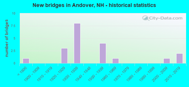
- New bridges - historical statistics
- 1Before 1900
- 31920-1929
- 81930-1939
- 41950-1959
- 11960-1969
- 12000-2009
- 22010-2019
FCC Registered Cell Phone Towers:
1- Mount Kearsarge Cell Site: 3.5 Miles Ssw Of Andover (Lat: 43.383333 Lon: -71.856389), Type: Tower, Structure height: 54.9 m, Overall height: 60.7 m, Call Sign: KNKQ431
Assigned Frequencies: 869.040 MHz, 869.040 MHz, 869.040 MHz, 869.040 MHz, 890.010 MHz, 890.010 MHz, 890.010 MHz, 890.010 MHz, 824.040 MHz, 824.040 MHz... (+6 more)Grant Date: 07/06/2017, Expiration Date: 05/20/2027, Certifier: Steven T CampbellRegistrant: Wilkinson Barker Knauer, LLP, 1800 M Street Nw, Suite 800n, Washington, DC 20036, Phone: (202) 383-3420, Fax: (202) 783-5851, Email:
FCC Registered Antenna Towers:
2- PETER M CONNOLLY, 3.5 Mi Ssw (Lat: 43.383333 Lon: -71.856667), Type: 60.7, Overall height: 54.7 m, Registrant: Holland & Knight LLP, Pconnoll@hklaw.Com, , Washi-ngton, Phone: (202) 862-5989
- 3.5 Mi Ssw (Lat: 43.383333 Lon: -71.856667), Type: 60.7, Overall height: 54.7 m, Registrant: United States Cellular Corporation, Chica-go, Phone: (773) 399-8900
FCC Registered Broadcast Land Mobile Towers:
3- Main St Currier & Phelps Gas Station Rts 4 & 11 (Lat: 43.437583 Lon: -71.815083), Call Sign: KDV685, Licensee ID: L00008549,
Assigned Frequencies: 31.9000 MHz, Grant Date: 08/08/2001, Expiration Date: 09/18/2011, Cancellation Date: 11/19/2003, Registrant: The State Of New Hampshire, Department Of Resources And Economic Development, 172 Pembroke Road, Concord, NH 03302-1856, Phone: (603) 271-2217, Fax: (603) 271-6488, Email:
- PROCTOR ACADEMY, 204 Main Street (Lat: 43.436972 Lon: -71.823333), Type: Building, Structure height: 9 m, Call Sign: WQZS883,
Assigned Frequencies: 462.925 MHz, Grant Date: 07/25/2017, Expiration Date: 07/25/2027, Certifier: Rachel Macduffie, Registrant: Visiplex, Inc., 1287 North Barclay Boulevard, Buffalo Grove, IL 60089, Phone: (847) 229-0250, Fax: (847) 229-0259, Email:
- Lat: 43.436389 Lon: -71.823333, Call Sign: WRTJ345,
Assigned Frequencies: 153.792 MHz, Grant Date: 06/23/2022, Expiration Date: 06/23/2032, Certifier: Marjorie M Roy, Registrant: Ossipee Mountain Electronics, 832 Whittier Hwy, Moultonboro, NH 03254, Phone: (603) 476-5581, Fax: (603) 476-5587, Email:
FCC Registered Microwave Towers:
5- Andover, Various Locations (Lat: 43.544917 Lon: -71.971583), Overall height: 6.1 m, Call Sign: WNTY222,
Assigned Frequencies: 956.256 MHz, Grant Date: 03/25/2020, Expiration Date: 05/08/2030, Registrant: Keller And Heckman LLP, 1001 G Street Nw, Suite 500 West, Washington, DC 20001, Phone: (202) 434-4100, Fax: (202) 434-4646, Email:
- KEARSARGE, 3.5 Mi Ssw (Lat: 43.383333 Lon: -71.856667), Type: Gtower, Structure height: 54.7 m, Overall height: 60.7 m, Call Sign: WPNL519,
Assigned Frequencies: 6555.00 MHz, Grant Date: 06/26/2018, Expiration Date: 06/01/2028, Certifier: Steven T Campbell, Registrant: Wilkinson Barker Knauer, LLP, 1800 M Street Nw, Suite 800n, Washington, DC 20036, Phone: (202) 383-3420, Fax: (202) 783-5851, Email:
- MT KEARSARGE, 3.5 Mi Ssw (Lat: 43.383333 Lon: -71.856667), Type: Ltower, Structure height: 54.7 m, Overall height: 60.7 m, Call Sign: WQMI783,
Assigned Frequencies: 6226.89 MHz, 10915.0 MHz, 10915.0 MHz, 10915.0 MHz, 6226.89 MHz, 6063.80 MHz, 10915.0 MHz, 6226.89 MHz, 6063.80 MHz, 10915.0 MHz... (+14 more), Grant Date: 07/22/2020, Expiration Date: 08/18/2030, Certifier: Dena Delucca, Registrant: New Hampshire Electric Cooperative, 579 Tenney Mountain Highway, Plymouth, NH 03264, Phone: (603) 536-1800, Email:
- MT KEARSARGE, 3.5 Mi Ssw (Lat: 43.383333 Lon: -71.856667), Type: Ltower, Structure height: 54.7 m, Overall height: 60.7 m, Call Sign: WQOE834,
Assigned Frequencies: 6345.49 MHz, 6256.54 MHz, 6286.19 MHz, 6345.49 MHz, 6256.54 MHz, 6286.19 MHz, 6345.49 MHz, 6256.54 MHz, 6286.19 MHz, 6197.24 MHz... (+30 more), Grant Date: 07/01/2021, Expiration Date: 09/06/2031, Certifier: James Kowalik, Registrant: Nh Dept. Of Safety/Emergency Services And Communications, 33 Hazen Dr (Mailing), Concord, NH 03305, Phone: (603) 528-7541, Fax: (603) 271-6629, Email:
- MT KEARSARG, 3.5 Mi Ssw (Lat: 43.383389 Lon: -71.856444), Type: Tower, Structure height: 54.9 m, Call Sign: KRD30,
Assigned Frequencies: 6605.00 MHz, 6404.79 MHz, 6555.00 MHz, Grant Date: 08/24/2021, Expiration Date: 11/14/2031, Registrant: State Of, Division Of Emergency Services New Hampshire, 33 Hazen Dr (Mailing), Concord, NH 03305, Phone: (603) 528-7541, Fax: (603) 271-6629, Email:
FCC Registered Paging Towers:
1- 3.5 Mi Ssw (Lat: 43.383333 Lon: -71.856667), Type: Tower, Structure height: 54.7 m, Overall height: 60.7 m, Call Sign: KDS417,
Assigned Frequencies: 152.030 MHz, Grant Date: 04/02/2019, Expiration Date: 04/01/2029, Certifier: Gerald W Blanchard, Registrant: Keller And Heckman LLP, 1001 G Street Nw, Suite 500 West, Washington, DC 20001, Phone: (202) 434-4100, Fax: (202) 434-4646, Email:
FCC Registered Amateur Radio Licenses:
14 (See the full list of FCC Registered Amateur Radio Licenses in Andover)FAA Registered Aircraft:
4- Aircraft: CESSNA 210L (Category: Land, Seats: 6, Weight: Up to 12,499 Pounds, Speed: 87 mph), Engine: CONT MOTOR IO 520 SERIES (285 HP) (Reciprocating)
N-Number: 1653X, N1653X, N-1653X, Serial Number: 21060688, Year manufactured: 1975, Airworthiness Date: 02/15/1975, Certificate Issue Date: 02/04/1997
Registrant (Individual): William Radzelovage, 95 Hoyt Rd, Andover, NH 03216 - Aircraft: PIPER PA-22-108 (Category: Land, Seats: 2, Weight: Up to 12,499 Pounds, Speed: 94 mph), Engine: LYCOMING 0-235 SERIES (115 HP) (Reciprocating)
N-Number: 4529Z, N4529Z, N-4529Z, Serial Number: 22-8032, Year manufactured: 1961, Airworthiness Date: 12/30/1960, Certificate Issue Date: 11/30/2009
Registrant (Individual): Michael R Daigle, 172 Boston Hill Rd # B, Andover, NH 03216 - Aircraft: TAYLORCRAFT BC12-D (Category: Land, Seats: 2, Weight: Up to 12,499 Pounds, Speed: 78 mph), Engine: CONT MOTOR A&C65 SERIES (65 HP) (Reciprocating)
N-Number: 96421, N96421, N-96421, Serial Number: 8721, Year manufactured: 1946, Airworthiness Date: 06/16/1956, Certificate Issue Date: 05/02/2011
Registrant (Individual): Roscoe A Iii Ammon, 162 Switch Rd, Andover, NH 03216 - Aircraft: TATKOVSKY JAMES G SAFARI (Category: Land, Seats: 2, Weight: Up to 12,499 Pounds), Engine: LYCOMING 0-320 SERIES (180 HP) (Reciprocating)
N-Number: 330JT, N330JT, N-330JT, Serial Number: 0474N, Year manufactured: 2004, Airworthiness Date: 03/25/2004, Certificate Issue Date: 02/27/2004
Registrant (Individual): James G Tatkovsky, 15 Rivers Edge Rd, Andover, NH 03216
Deregistered: Cancel Date: 06/19/2019
2005 - 2018 National Fire Incident Reporting System (NFIRS) incidents
- Fire incident types reported to NFIRS in Andover, NH
- 9067.7%Structure Fires
- 1914.3%Other
- 1813.5%Outside Fires
- 64.5%Mobile Property/Vehicle Fires
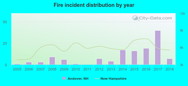 Based on the data from the years 2005 - 2018 the average number of fire incidents per year is 10. The highest number of fires - 40 took place in 2017, and the least - 0 in 2011. The data has an increasing trend.
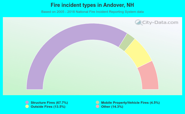 When looking into fire subcategories, the most incidents belonged to: Structure Fires (67.7%), and Other (14.3%).
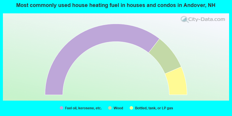
- 71.0%Fuel oil, kerosene, etc.
- 16.1%Wood
- 12.9%Bottled, tank, or LP gas
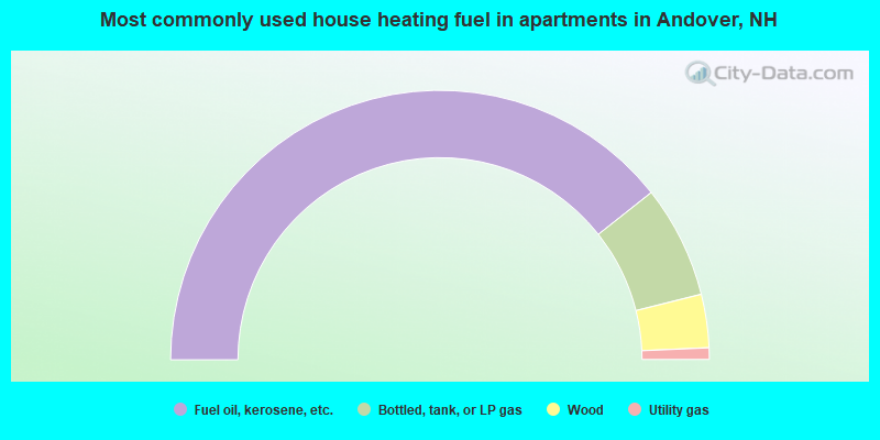
- 78.7%Fuel oil, kerosene, etc.
- 13.5%Bottled, tank, or LP gas
- 6.4%Wood
- 1.4%Utility gas
Andover compared to New Hampshire state average:
- Unemployed percentage significantly below state average.
- Black race population percentage below state average.
- Hispanic race population percentage significantly below state average.
- Foreign-born population percentage significantly below state average.
- Renting percentage below state average.
- Length of stay since moving in significantly above state average.
- Number of rooms per house significantly below state average.
- House age significantly below state average.

|
|
Total of 24 patent applications in 2008-2024.