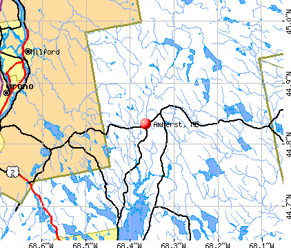
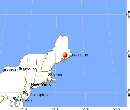
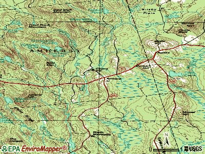
Amherst, Maine
Submit your own pictures of this town and show them to the world
- OSM Map
- General Map
- Google Map
- MSN Map
Population change since 2000: +15.2%
 |
| Males: 139 | |
| Females: 126 |
| Median resident age: | 47.4 years |
| Maine median age: | 43.0 years |
Zip codes: 04605.
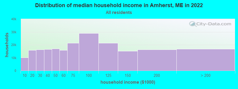
| Amherst: | $47,533 |
| ME: | $69,543 |
Estimated per capita income in 2022: $33,599 (it was $16,548 in 2000)
Amherst town income, earnings, and wages data
Estimated median house or condo value in 2022: $180,709 (it was $63,100 in 2000)
| Amherst: | $180,709 |
| ME: | $290,600 |
Mean prices in 2022: all housing units: $379,336; detached houses: $396,802; townhouses or other attached units: $600,716; in 2-unit structures: $274,479; in 3-to-4-unit structures: $212,346; in 5-or-more-unit structures: $146,369; mobile homes: $158,183; occupied boats, rvs, vans, etc.: $16,454
Detailed information about poverty and poor residents in Amherst, ME


- 26098.1%White alone
- 41.5%Two or more races
- 10.4%Hispanic
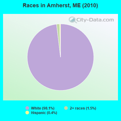
Races in Amherst detailed stats: ancestries, foreign born residents, place of birth
 Recent articles from our blog. Our writers, many of them Ph.D. graduates or candidates, create easy-to-read articles on a wide variety of topics.

 | Small Houses Part 3 (111 replies) |
| What are you doing? (74 replies) |
| Starting to really think relocating to new england (26 replies) |
| Possibly relocating to Maine from Texas, Buying Land, etc... (102 replies) |
| Maine weather thread (3207 replies) |
| Photos of Maine (4586 replies) |
Latest news from Amherst, ME collected exclusively by city-data.com from local newspapers, TV, and radio stations
Ancestries: English (23.0%), Irish (20.0%), German (13.9%), French (11.3%), United States (6.5%), Swedish (3.9%).
Current Local Time: EST time zone
Elevation: 301 feet
Land area: 39.0 square miles.
Population density: 6.8 people per square mile (very low).
4 residents are foreign born
| This town: | 1.7% |
| Maine: | 2.9% |
| Amherst town: | 0.7% ($458) |
| Maine: | 1.5% ($1,417) |
Nearest city with pop. 50,000+: Portland, ME  (123.3 miles , pop. 64,249).
Nearest city with pop. 200,000+: Boston, MA (220.1 miles , pop. 589,141).
Nearest city with pop. 1,000,000+: Bronx, NY (391.5 miles , pop. 1,332,650).
Nearest cities:
), )Latitude: 44.83 N, Longitude: 68.39 W
Area code commonly used in this area: 207

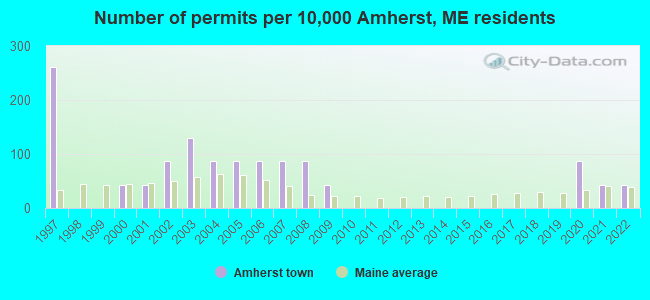
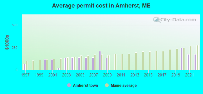
Single-family new house construction building permits:
- 2022: 1 building, cost: $175,000
- 2021: 1 building, cost: $175,000
- 2020: 2 buildings, average cost: $248,200
- 2009: 1 building, cost: $137,000
- 2008: 2 buildings, average cost: $210,000
- 2007: 2 buildings, average cost: $138,800
- 2006: 2 buildings, average cost: $138,800
- 2005: 2 buildings, average cost: $138,800
- 2004: 2 buildings, average cost: $138,800
- 2003: 3 buildings, average cost: $132,800
- 2002: 2 buildings, average cost: $25,000
- 2001: 1 building, cost: $121,400
- 2000: 1 building, cost: $118,000
- 1997: 6 buildings, average cost: $66,700
| Here: | 2.7% |
| Maine: | 3.4% |
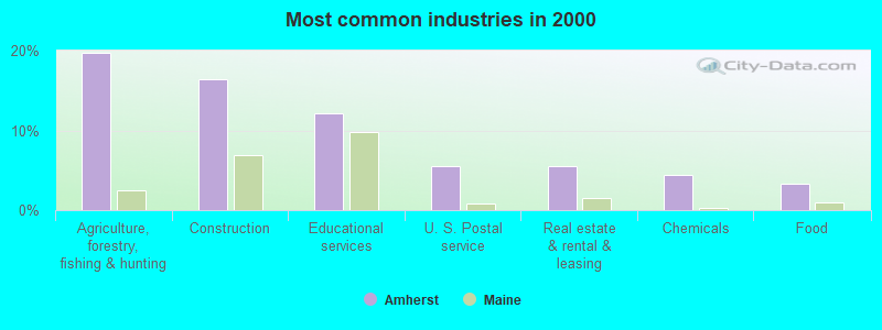
- Agriculture, forestry, fishing & hunting (19.8%)
- Construction (16.5%)
- Educational services (12.1%)
- U. S. Postal service (5.5%)
- Real estate & rental & leasing (5.5%)
- Chemicals (4.4%)
- Food (3.3%)
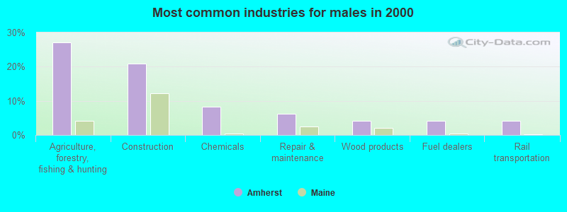
- Agriculture, forestry, fishing & hunting (27.1%)
- Construction (20.8%)
- Chemicals (8.3%)
- Repair & maintenance (6.2%)
- Wood products (4.2%)
- Fuel dealers (4.2%)
- Rail transportation (4.2%)
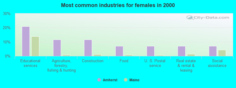
- Educational services (20.9%)
- Agriculture, forestry, fishing & hunting (11.6%)
- Construction (11.6%)
- Food (7.0%)
- U. S. Postal service (7.0%)
- Real estate & rental & leasing (7.0%)
- Social assistance (7.0%)
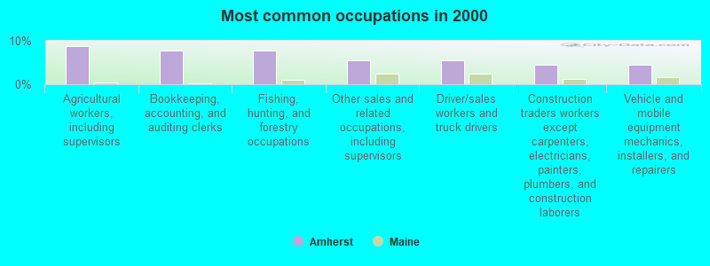
- Agricultural workers, including supervisors (8.8%)
- Bookkeeping, accounting, and auditing clerks (7.7%)
- Fishing, hunting, and forestry occupations (7.7%)
- Other sales and related occupations, including supervisors (5.5%)
- Driver/sales workers and truck drivers (5.5%)
- Construction traders workers except carpenters, electricians, painters, plumbers, and construction laborers (4.4%)
- Vehicle and mobile equipment mechanics, installers, and repairers (4.4%)
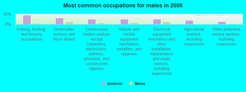
- Fishing, hunting, and forestry occupations (14.6%)
- Driver/sales workers and truck drivers (10.4%)
- Construction traders workers except carpenters, electricians, painters, plumbers, and construction laborers (8.3%)
- Vehicle and mobile equipment mechanics, installers, and repairers (8.3%)
- Electrical equipment mechanics and other installation, maintenance, and repair workers, including supervisors (8.3%)
- Agricultural workers, including supervisors (6.2%)
- Other protective service workers, including supervisors (4.2%)
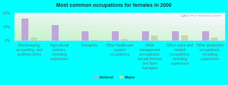
- Bookkeeping, accounting, and auditing clerks (16.3%)
- Agricultural workers, including supervisors (11.6%)
- Therapists (7.0%)
- Other healthcare support occupations (7.0%)
- Other management occupations, except farmers and farm managers (7.0%)
- Other sales and related occupations, including supervisors (7.0%)
- Other production occupations, including supervisors (7.0%)
Average climate in Amherst, Maine
Based on data reported by over 4,000 weather stations


(lower is better)
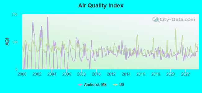
Air Quality Index (AQI) level in 2023 was 61.1. This is about average.
| City: | 61.1 |
| U.S.: | 72.6 |
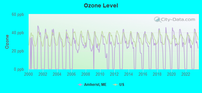
Ozone [ppb] level in 2023 was 33.6. This is about average. Closest monitor was 14.3 miles away from the city center.
| City: | 33.6 |
| U.S.: | 33.3 |
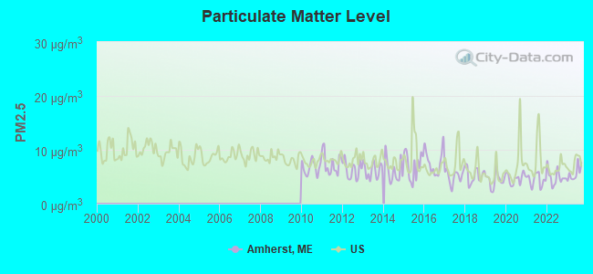
Particulate Matter (PM2.5) [µg/m3] level in 2023 was 5.62. This is significantly better than average. Closest monitor was 14.4 miles away from the city center.
| City: | 5.62 |
| U.S.: | 8.11 |
Earthquake activity:
Amherst-area historical earthquake activity is significantly above Maine state average. It is 82% smaller than the overall U.S. average.On 10/16/2012 at 23:12:25, a magnitude 4.7 (4.7 ML, Depth: 10.0 mi, Class: Light, Intensity: IV - V) earthquake occurred 141.2 miles away from the city center
On 4/20/2002 at 10:50:47, a magnitude 5.3 (5.3 ML, Depth: 3.0 mi, Class: Moderate, Intensity: VI - VII) earthquake occurred 262.0 miles away from Amherst center
On 4/20/2002 at 10:50:47, a magnitude 5.2 (5.2 MB, 4.2 MS, 5.2 MW, 5.0 MW) earthquake occurred 263.2 miles away from the city center
On 1/19/1982 at 00:14:42, a magnitude 4.7 (4.5 MB, 4.7 MD, 4.5 LG) earthquake occurred 184.0 miles away from the city center
On 10/7/1983 at 10:18:46, a magnitude 5.3 (5.1 MB, 5.3 LG, 5.1 ML) earthquake occurred 300.4 miles away from Amherst center
On 10/3/2006 at 00:07:38, a magnitude 3.7 (3.7 MD, Depth: 6.2 mi, Class: Light, Intensity: II - III) earthquake occurred 34.4 miles away from the city center
Magnitude types: regional Lg-wave magnitude (LG), body-wave magnitude (MB), duration magnitude (MD), local magnitude (ML), surface-wave magnitude (MS), moment magnitude (MW)
Natural disasters:
The number of natural disasters in Hancock County (18) is near the US average (15).Major Disasters (Presidential) Declared: 11
Emergencies Declared: 6
Causes of natural disasters: Floods: 9, Storms: 8, Snows: 5, Blizzard: 1, Heavy Rain: 1, Hurricane: 1, Ice Storm: 1, Landslide: 1, Snowfall: 1, Wind: 1, Winter Storm: 1, Other: 2 (Note: some incidents may be assigned to more than one category).
Colleges/universities with over 2000 students nearest to Amherst:
- University of Maine (about 15 miles; Orono, ME; Full-time enrollment: 8,931)
- Husson University (about 20 miles; Bangor, ME; FT enrollment: 2,421)
- University of Maine at Augusta (about 78 miles; Augusta, ME; FT enrollment: 3,204)
- University of Maine at Farmington (about 88 miles; Farmington, ME; FT enrollment: 2,036)
- Southern Maine Community College (about 123 miles; South Portland, ME; FT enrollment: 4,666)
- University of Southern Maine (about 124 miles; Portland, ME; FT enrollment: 6,647)
- Saint Joseph's College of Maine (about 125 miles; Standish, ME; FT enrollment: 2,010)
Points of interest:
Cemeteries: Amherst Cemetery (1), Hadley Cemetery (2). Display/hide their locations on the map
Lakes: Trout Pond (A), Debec Pond (B), Ducktail Pond (C), Dutton Pond (D), East Great Works Pond (E), Grassy Pond (F), Halfmile Pond (G), Indian Camp Ponds (H). Display/hide their locations on the map
Streams, rivers, and creeks: Indian Camp Brook (A), Warm Brook (B), Chick Brook (C). Display/hide their locations on the map
Drinking water stations with addresses in Amherst and their reported violations in the past:
AMHERST GENERAL STORE (Population served: 25, Groundwater):Past health violations:Past monitoring violations:
- MCL, Monthly (TCR) - In APR-2014, Contaminant: Coliform. Follow-up actions: St Public Notif requested (MAY-13-2014), St Formal NOV issued (MAY-13-2014), St Public Notif received (MAY-30-2014), St Compliance achieved (JUN-09-2014)
- MCL, Monthly (TCR) - In FEB-2014, Contaminant: Coliform. Follow-up actions: St Public Notif requested (MAR-03-2014), St Formal NOV issued (MAR-03-2014), St Public Notif received (MAR-14-2014), St Compliance achieved (MAR-25-2014)
- MCL, Monthly (TCR) - In JAN-2014, Contaminant: Coliform. Follow-up actions: St Public Notif requested (JAN-30-2014), St Formal NOV issued (JAN-30-2014), St Public Notif received (FEB-10-2014), St Compliance achieved (MAR-25-2014)
- MCL, Acute (TCR) - In OCT-2005, Contaminant: Coliform. Follow-up actions: St Tech Assistance Visit (OCT-27-2005), St Violation/Reminder Notice (OCT-27-2005), St Public Notif requested (OCT-27-2005), St Boil Water Order (OCT-27-2005), St Public Notif received (2 times from NOV-10-2005 to NOV-10-2005), St Compliance achieved (JAN-17-2007)
- 3 routine major monitoring violations
| This town: | 2.2 people |
| Maine: | 2.3 people |
| This town: | 64.5% |
| Whole state: | 62.9% |
| This town: | 12.4% |
| Whole state: | 9.4% |
Likely homosexual households (counted as self-reported same-sex unmarried-partner households)
- Lesbian couples: 2.5% of all households
- Gay men: 0.8% of all households
| This town: | 14.9% |
| Whole state: | 10.9% |
| This town: | 6.8% |
| Whole state: | 4.1% |
For population 15 years and over in Amherst:
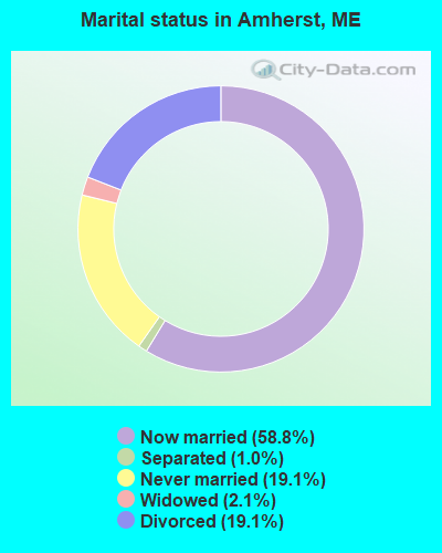
- Never married: 19.1%
- Now married: 58.8%
- Separated: 1.0%
- Widowed: 2.1%
- Divorced: 19.1%
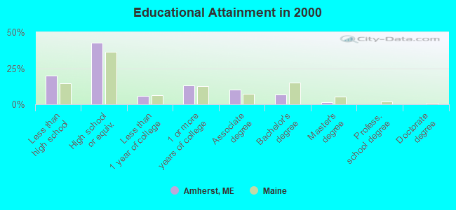
For population 25 years and over in Amherst:
- High school or higher: 80.2%
- Bachelor's degree or higher: 8.5%
- Graduate or professional degree: 1.7%
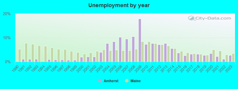
- Unemployed: 12.5%
- Mean travel time to work (commute): 30.8 minutes
| Here: | 8.7 |
| Maine average: | 11.2 |


Graphs represent county-level data. Detailed 2008 Election Results
Religion statistics for Amherst, ME (based on Hancock County data)


| Religion | Adherents | Congregations |
|---|---|---|
| Mainline Protestant | 4,691 | 58 |
| Catholic | 2,523 | 9 |
| Evangelical Protestant | 1,288 | 23 |
| Other | 820 | 11 |
| None | 45,096 | - |
Food Environment Statistics:
| Hancock County: | 6.01 / 10,000 pop. |
| Maine: | 2.80 / 10,000 pop. |
| Hancock County: | 1.69 / 10,000 pop. |
| Maine: | 2.20 / 10,000 pop. |
| Hancock County: | 4.89 / 10,000 pop. |
| State: | 5.75 / 10,000 pop. |
| Here: | 21.61 / 10,000 pop. |
| State: | 11.02 / 10,000 pop. |
| This county: | 7.4% |
| Maine: | 8.2% |
| Hancock County: | 25.4% |
| Maine: | 25.0% |
Strongest AM radio stations in Amherst:
- WZON (620 AM; 5 kW; BANGOR, ME; Owner: THE ZONE CORPORATION)
- WABI (910 AM; 5 kW; BANGOR, ME; Owner: CLEAR CHANNEL BROADCASTING LICENSES, INC.)
- WDEA (1370 AM; 5 kW; ELLSWORTH, ME; Owner: CUMULUS LICENSING CORP.)
- WNZS (1340 AM; 1 kW; VEAZIE, ME; Owner: WATERFRONT COMMUNICATIONS INC.)
- WSKW (1160 AM; 10 kW; SKOWHEGAN, ME; Owner: MOUNTAIN WIRELESS, INCORPORATED)
- WRKO (680 AM; 50 kW; BOSTON, MA; Owner: ENTERCOM BOSTON LICENSE, LLC)
- WEEI (850 AM; 50 kW; BOSTON, MA; Owner: ENTERCOM BOSTON LICENSE, LLC)
- WTME (780 AM; 10 kW; RUMFORD, ME; Owner: MOUNTAIN VALLEY BROADCASTING, INC.)
- WBZ (1030 AM; 50 kW; BOSTON, MA; Owner: INFINITY BROADCASTING OPERATIONS, INC.)
- WCRN (830 AM; 50 kW; WORCESTER, MA; Owner: CARTER BROADCASTING CORPORATION)
- WNNZ (640 AM; 50 kW; WESTFIELD, MA; Owner: CLEAR CHANNEL BROADCASTING LICENSES, INC.)
- WKOX (1200 AM; 50 kW; FRAMINGHAM, MA; Owner: CAPSTAR TX LIMITED PARTNERSHIP)
- WALE (990 AM; 50 kW; GREENVILLE, RI; Owner: NORTH AMERICAN BROADCASTING CO., INC.)
Strongest FM radio stations in Amherst:
- WMEH (90.9 FM; BANGOR, ME; Owner: MAINE PUBLIC BROADCASTING CORPORATION)
- WEZQ (92.9 FM; BANGOR, ME; Owner: CUMULUS LICENSING CORP.)
- WHCF (88.5 FM; BANGOR, ME; Owner: BANGOR BAPTIST CHURCH)
- WWMJ (95.7 FM; ELLSWORTH, ME; Owner: CUMULUS LICENSING CORP.)
- WVOM (103.9 FM; HOWLAND, ME; Owner: CLEAR CHANNEL BROADCASTING LICENSES, INC.)
- WKIT-FM (100.3 FM; BREWER, ME; Owner: THE ZONE CORPORATION)
- WNSX (97.7 FM; WINTER HARBOR, ME; Owner: CLEAR CHANNEL BROADCASTING LICENSES, INC.)
- WBFB (104.7 FM; BELFAST, ME; Owner: CLEAR CHANNEL BROADCASTING LICENSES, INC.)
- WWBX (97.1 FM; BANGOR, ME; Owner: CLEAR CHANNEL BROADCASTING LICENSES, INC.)
- WERU-FM (89.9 FM; BLUE HILL, ME; Owner: SALT POND COMMUNITY B/C COMPANY)
- WBZN (107.3 FM; OLD TOWN, ME; Owner: CUMULUS LICENSING CORP.)
- WLKE (99.1 FM; BAR HARBOR, ME; Owner: CLEAR CHANNEL BROADCASTING LICENSES, INC.)
- WFZX (101.7 FM; SEARSPORT, ME; Owner: CLEAR CHANNEL BROADCASTING LICENSES, INC.)
- WBQI (107.7 FM; BAR HARBOR, ME; Owner: MARINER BROADCASTING, L.P.)
- WQCB (106.5 FM; BREWER, ME; Owner: CUMULUS LICENSING CORP.)
- WMEB-FM (91.9 FM; ORONO, ME; Owner: UNIVERSITY OF MAINE SYSTEM)
TV broadcast stations around Amherst:
- WMEB-TV (Channel 12; ORONO, ME; Owner: MAINE PUBLIC BROADCASTING CORPORATION)
- W66CL (Channel 66; BANGOR, ME; Owner: MS COMMUNICATIONS, LLC)
- WBAN-LP (Channel 9; BANGOR, ME; Owner: BANGOR MEDIA GROUP, LLC)
- WLBZ (Channel 2; BANGOR, ME; Owner: PACIFIC AND SOUTHERN COMPANY, INC.)
- WVII-TV (Channel 7; BANGOR, ME; Owner: BANGOR COMMUNICATIONS, INC.)
- WBGR-LP (Channel 33; BANGOR/DEDHAM, ME; Owner: MAINE FAMILY BROADCASTING, INC.)
- WFVX-LP (Channel 22; BANGOR, ME; Owner: ROCKFLEET BROADCASTING III, LLC)
- W39CC (Channel 39; BANGOR, ME; Owner: MS COMMUNICATIONS, LLC)
- W42BZ (Channel 42; BANGOR, ME; Owner: MS COMMUNICATIONS, LLC)
- W50BX (Channel 50; BANGOR, ME; Owner: MS COMMUNICATIONS, LLC)
- W54CG (Channel 54; BANGOR, ME; Owner: MS COMMUNICATIONS, LLC)
- WCKD-LP (Channel 30; BANGOR/DEDHAM, ME; Owner: J. MCLEOD, ME FAMILY B/CING., INC.)
- Amherst, Maine
- Fatal accident count8
- Vehicles involved in fatal accidents14
- Fatal accidents involving drunk persons:2
- Fatalities9
- Persons involved in fatal accidents19
- Pedestrians involved in fatal accidents0
- Maine average
- Fatal accident count1338
- Vehicles involved in fatal accidents1892
- Fatal accidents involving drunk persons482
- Fatalities1471
- Persons involved in fatal accidents3100
- Pedestrians involved in fatal accidents106
- National Bridge Inventory (NBI) Statistics
- 4Number of bridges
- 46ft / 13.8mTotal length
- 4,090Total average daily traffic
- 203Total average daily truck traffic
- 5,805Total future (year 2036) average daily traffic
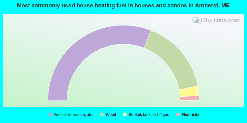
- 61.9%Fuel oil, kerosene, etc.
- 32.0%Wood
- 4.1%Bottled, tank, or LP gas
- 2.1%Electricity
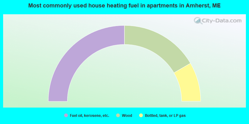
- 50.0%Fuel oil, kerosene, etc.
- 33.3%Wood
- 16.7%Bottled, tank, or LP gas
Amherst compared to Maine state average:
- Median house value below state average.
- Black race population percentage significantly below state average.
- Hispanic race population percentage significantly below state average.
- Median age above state average.
- Foreign-born population percentage below state average.
- Renting percentage significantly below state average.
- Length of stay since moving in significantly above state average.
- Number of rooms per house significantly below state average.
- House age significantly below state average.
- Number of college students significantly below state average.
- Percentage of population with a bachelor's degree or higher significantly below state average.