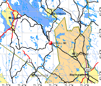
Alton, New Hampshire

Alton: Peaceful Geese

Alton: A road for Rufus

Alton: Along the Merry Meeting River
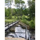
Alton: An old dam along the Merry Meeting River
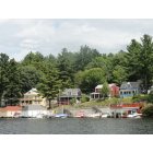
Alton: Homes on Alton Bay, Lake Winnipesaukee
- add
your
Submit your own pictures of this town and show them to the world
- OSM Map
- General Map
- Google Map
- MSN Map
Population change since 2000: +16.6%
 |
| Males: 2,635 | |
| Females: 2,615 |
| Median resident age: | 46.2 years |
| New Hampshire median age: | 43.9 years |
Zip codes: 03809.
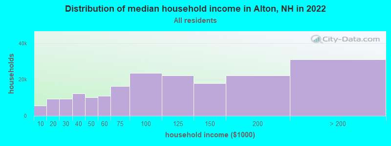
| Alton: | $79,679 |
| NH: | $89,992 |
Estimated per capita income in 2022: $50,839 (it was $25,940 in 2000)
Alton town income, earnings, and wages data
Estimated median house or condo value in 2022: $413,264 (it was $127,400 in 2000)
| Alton: | $413,264 |
| NH: | $384,700 |
Mean prices in 2022: all housing units: $464,290; detached houses: $503,643; townhouses or other attached units: $657,649; in 2-unit structures: $254,871; in 3-to-4-unit structures: $448,739; in 5-or-more-unit structures: $289,404; mobile homes: $118,878
Detailed information about poverty and poor residents in Alton, NH


- 5,12097.5%White alone
- 591.1%Hispanic
- 430.8%Two or more races
- 150.3%Asian alone
- 70.1%American Indian alone
- 40.08%Black alone
- 20.04%Native Hawaiian and Other
Pacific Islander alone
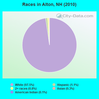
Races in Alton detailed stats: ancestries, foreign born residents, place of birth
According to our research of New Hampshire and other state lists, there were 10 registered sex offenders living in Alton, New Hampshire as of May 17, 2024.
The ratio of all residents to sex offenders in Alton is 525 to 1.
The ratio of registered sex offenders to all residents in this city is near the state average.
Type |
2009 |
2010 |
2011 |
2012 |
2013 |
2014 |
2015 |
2016 |
2017 |
2018 |
2019 |
2020 |
2021 |
2022 |
|---|---|---|---|---|---|---|---|---|---|---|---|---|---|---|
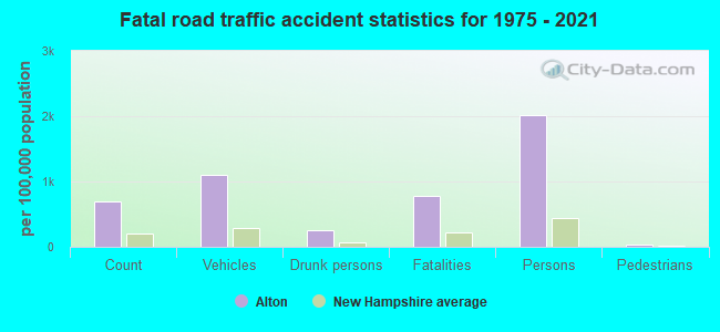
| Murders (per 100,000) | 0 (0.0) | 0 (0.0) | 0 (0.0) | 0 (0.0) | 0 (0.0) | 0 (0.0) | 0 (0.0) | 0 (0.0) | 0 (0.0) | 0 (0.0) | 2 (37.5) | 0 (0.0) | 0 (0.0) | 0 (0.0) |
| Rapes (per 100,000) | 0 (0.0) | 0 (0.0) | 1 (19.0) | 0 (0.0) | 4 (75.6) | 1 (18.9) | 8 (150.7) | 6 (112.4) | 8 (150.0) | 7 (130.8) | 5 (93.7) | 9 (168.4) | 14 (257.1) | 6 (99.1) |
| Robberies (per 100,000) | 1 (19.4) | 0 (0.0) | 0 (0.0) | 1 (19.0) | 1 (18.9) | 1 (18.9) | 0 (0.0) | 0 (0.0) | 0 (0.0) | 0 (0.0) | 0 (0.0) | 0 (0.0) | 0 (0.0) | 0 (0.0) |
| Assaults (per 100,000) | 0 (0.0) | 2 (38.1) | 6 (114.1) | 0 (0.0) | 4 (75.6) | 1 (18.9) | 5 (94.2) | 2 (37.5) | 6 (112.5) | 3 (56.0) | 3 (56.2) | 6 (112.3) | 6 (110.2) | 1 (16.5) |
| Burglaries (per 100,000) | 27 (524.5) | 26 (495.2) | 55 (1,046) | 24 (455.1) | 26 (491.5) | 13 (245.5) | 16 (301.4) | 4 (74.9) | 16 (300.0) | 4 (74.7) | 8 (149.8) | 4 (74.9) | 2 (36.7) | 7 (115.6) |
| Thefts (per 100,000) | 37 (718.7) | 52 (990.5) | 91 (1,731) | 75 (1,422) | 67 (1,267) | 62 (1,171) | 45 (847.6) | 34 (636.9) | 39 (731.2) | 45 (840.7) | 24 (449.5) | 17 (318.2) | 17 (312.2) | 22 (363.4) |
| Auto thefts (per 100,000) | 9 (174.8) | 2 (38.1) | 0 (0.0) | 1 (19.0) | 5 (94.5) | 0 (0.0) | 1 (18.8) | 0 (0.0) | 2 (37.5) | 3 (56.0) | 2 (37.5) | 3 (56.1) | 1 (18.4) | 3 (49.6) |
| Arson (per 100,000) | 3 (58.3) | 2 (38.1) | 0 (0.0) | 1 (19.0) | 0 (0.0) | 0 (0.0) | 0 (0.0) | 0 (0.0) | 0 (0.0) | 0 (0.0) | 0 (0.0) | 0 (0.0) | 0 (0.0) | 0 (0.0) |
| City-Data.com crime index | 85.3 | 85.0 | 180.5 | 95.9 | 173.9 | 88.6 | 195.9 | 128.1 | 195.7 | 159.2 | 192.5 | 179.7 | 244.3 | 109.2 |
The City-Data.com crime index weighs serious crimes and violent crimes more heavily. Higher means more crime, U.S. average is 246.1. It adjusts for the number of visitors and daily workers commuting into cities.
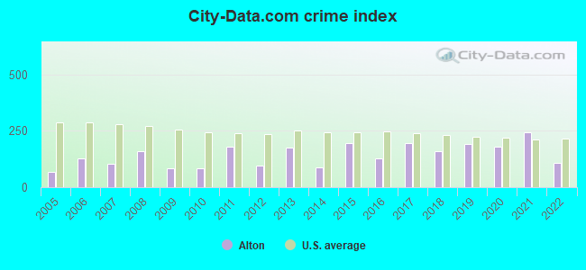
Crime rate in Alton detailed stats: murders, rapes, robberies, assaults, burglaries, thefts, arson
Full-time law enforcement employees in 2021, including police officers: 14 (12 officers - 11 male; 1 female).
| Officers per 1,000 residents here: | 2.20 |
| New Hampshire average: | 2.14 |
 Recent articles from our blog. Our writers, many of them Ph.D. graduates or candidates, create easy-to-read articles on a wide variety of topics.


Latest news from Alton, NH collected exclusively by city-data.com from local newspapers, TV, and radio stations
Ancestries: English (27.2%), Irish (16.7%), French (11.9%), German (10.2%), United States (8.7%), Italian (6.2%).
Current Local Time: EST time zone
Incorporated in 1796
Elevation: 563 feet
Land area: 63.1 square miles.
Population density: 83 people per square mile (very low).
136 residents are foreign born (1.5% Europe, 1.2% North America, 0.3% Asia).
| This town: | 3.0% |
| New Hampshire: | 4.4% |
| Alton town: | 1.5% ($1,946) |
| New Hampshire: | 2.3% ($2,946) |
Nearest city with pop. 50,000+: Manchester, NH  (36.2 miles , pop. 107,006).
Nearest city with pop. 200,000+: Boston, MA (80.9 miles , pop. 589,141).
Nearest city with pop. 1,000,000+: Bronx, NY (227.1 miles , pop. 1,332,650).
Nearest cities:
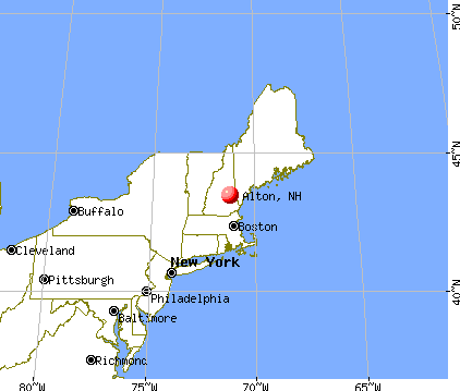
), ), Latitude: 43.49 N, Longitude: 71.24 W
Area code: 603

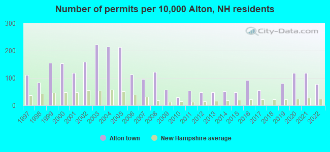
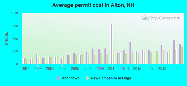
Single-family new house construction building permits:
- 2022: 35 buildings, average cost: $400,300
- 2021: 53 buildings, average cost: $467,100
- 2020: 53 buildings, average cost: $248,200
- 2019: 37 buildings, average cost: $374,700
- 2017: 25 buildings, average cost: $279,200
- 2016: 42 buildings, average cost: $276,600
- 2015: 22 buildings, average cost: $263,500
- 2014: 23 buildings, average cost: $434,400
- 2013: 22 buildings, average cost: $269,200
- 2012: 22 buildings, average cost: $212,200
- 2011: 24 buildings, average cost: $785,000
- 2010: 13 buildings, average cost: $312,000
- 2009: 26 buildings, average cost: $300,800
- 2008: 55 buildings, average cost: $308,400
- 2007: 43 buildings, average cost: $238,600
- 2006: 51 buildings, average cost: $185,000
- 2005: 96 buildings, average cost: $218,100
- 2004: 97 buildings, average cost: $182,500
- 2003: 100 buildings, average cost: $131,000
- 2002: 72 buildings, average cost: $137,900
- 2001: 53 buildings, average cost: $133,900
- 2000: 69 buildings, average cost: $120,900
- 1999: 70 buildings, average cost: $195,200
- 1998: 38 buildings, average cost: $98,900
- 1997: 50 buildings, average cost: $123,600
| Here: | 2.4% |
| New Hampshire: | 2.5% |
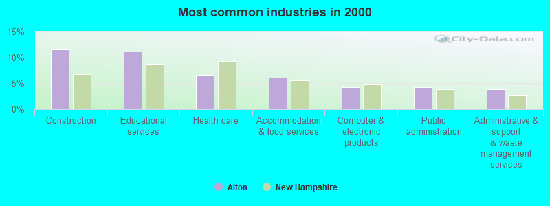
- Construction (11.6%)
- Educational services (11.1%)
- Health care (6.7%)
- Accommodation & food services (6.0%)
- Computer & electronic products (4.3%)
- Public administration (4.2%)
- Administrative & support & waste management services (3.9%)
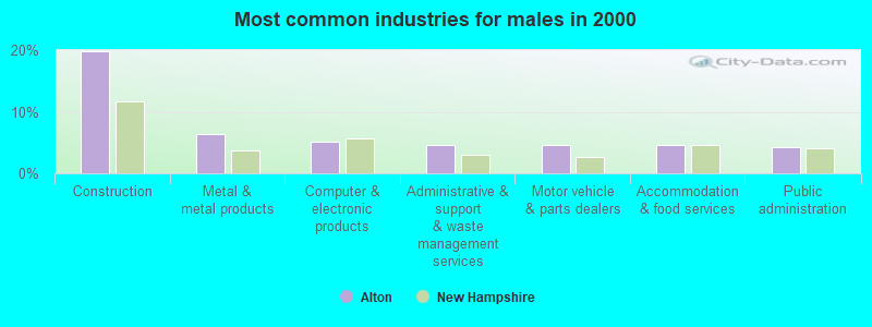
- Construction (19.9%)
- Metal & metal products (6.3%)
- Computer & electronic products (5.1%)
- Administrative & support & waste management services (4.6%)
- Motor vehicle & parts dealers (4.6%)
- Accommodation & food services (4.5%)
- Public administration (4.3%)
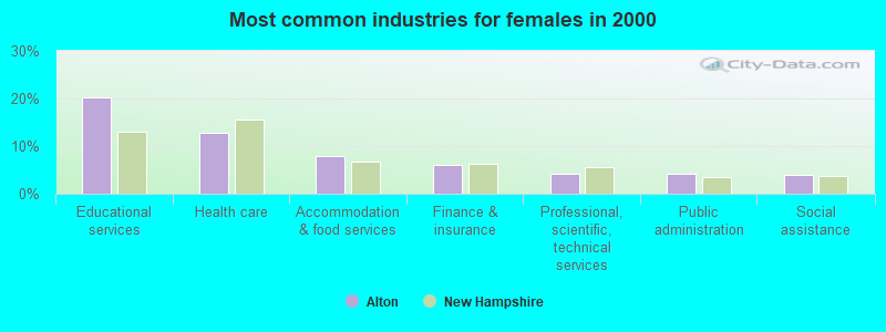
- Educational services (20.3%)
- Health care (12.8%)
- Accommodation & food services (7.9%)
- Finance & insurance (6.1%)
- Professional, scientific, technical services (4.2%)
- Public administration (4.1%)
- Social assistance (4.0%)
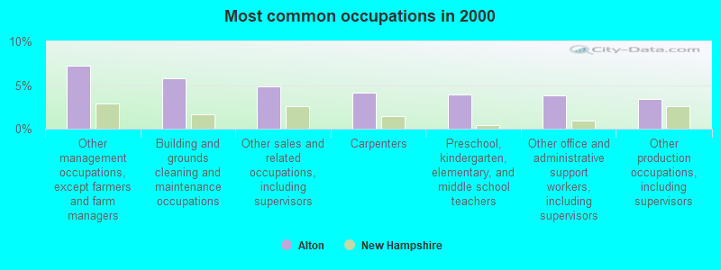
- Other management occupations, except farmers and farm managers (7.2%)
- Building and grounds cleaning and maintenance occupations (5.8%)
- Other sales and related occupations, including supervisors (4.8%)
- Carpenters (4.1%)
- Preschool, kindergarten, elementary, and middle school teachers (3.9%)
- Other office and administrative support workers, including supervisors (3.8%)
- Other production occupations, including supervisors (3.4%)
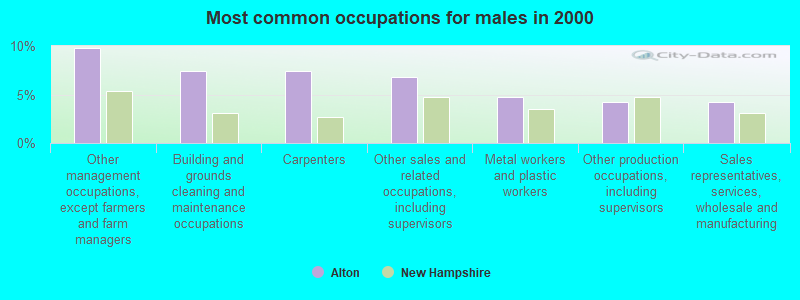
- Other management occupations, except farmers and farm managers (9.8%)
- Building and grounds cleaning and maintenance occupations (7.4%)
- Carpenters (7.4%)
- Other sales and related occupations, including supervisors (6.8%)
- Metal workers and plastic workers (4.7%)
- Other production occupations, including supervisors (4.2%)
- Sales representatives, services, wholesale and manufacturing (4.2%)

- Preschool, kindergarten, elementary, and middle school teachers (8.7%)
- Other office and administrative support workers, including supervisors (7.1%)
- Registered nurses (5.7%)
- Secretaries and administrative assistants (4.6%)
- Other teachers, instructors, education, training, and library occupations (4.4%)
- Other management occupations, except farmers and farm managers (3.9%)
- Building and grounds cleaning and maintenance occupations (3.7%)
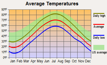
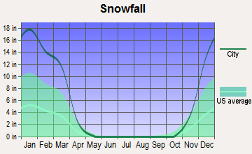
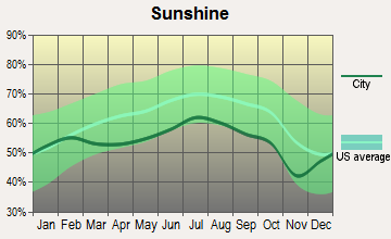
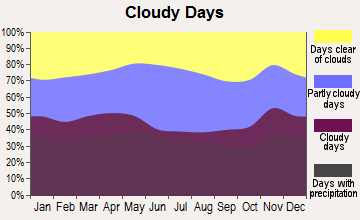
Average climate in Alton, New Hampshire
Based on data reported by over 4,000 weather stations
(lower is better)
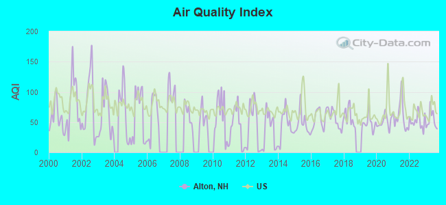
Air Quality Index (AQI) level in 2023 was 53.1. This is better than average.
| City: | 53.1 |
| U.S.: | 72.6 |
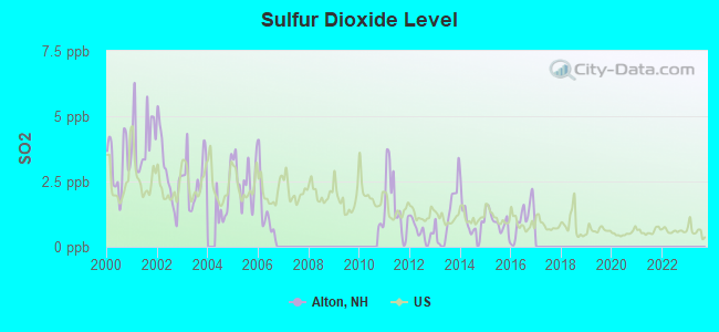
Sulfur Dioxide (SO2) [ppb] level in 2016 was 1.05. This is significantly better than average. Closest monitor was 23.1 miles away from the city center.
| City: | 1.05 |
| U.S.: | 1.51 |
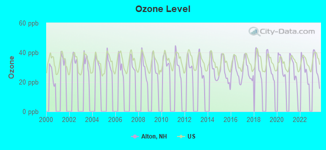
Ozone [ppb] level in 2023 was 30.5. This is about average. Closest monitor was 10.8 miles away from the city center.
| City: | 30.5 |
| U.S.: | 33.3 |
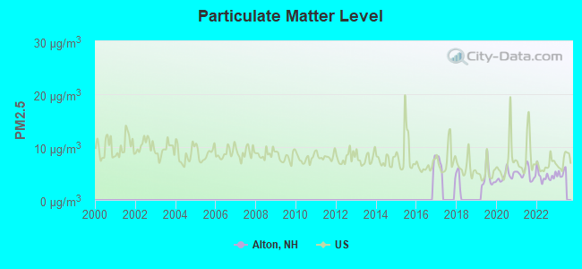
Particulate Matter (PM2.5) [µg/m3] level in 2022 was 4.52. This is significantly better than average. Closest monitor was 10.8 miles away from the city center.
| City: | 4.52 |
| U.S.: | 8.11 |
Tornado activity:
Alton-area historical tornado activity is slightly below New Hampshire state average. It is 59% smaller than the overall U.S. average.
On 6/22/1981, a category F2 (max. wind speeds 113-157 mph) tornado 5.2 miles away from the Alton town center caused between $500,000 and $5,000,000 in damages.
On 7/18/1963, a category F2 tornado 8.1 miles away from the town center caused between $5000 and $50,000 in damages.
Earthquake activity:
Alton-area historical earthquake activity is significantly above New Hampshire state average. It is 72% smaller than the overall U.S. average.On 4/20/2002 at 10:50:47, a magnitude 5.3 (5.3 ML, Depth: 3.0 mi, Class: Moderate, Intensity: VI - VII) earthquake occurred 141.4 miles away from the city center
On 1/19/1982 at 00:14:42, a magnitude 4.7 (4.5 MB, 4.7 MD, 4.5 LG, Class: Light, Intensity: IV - V) earthquake occurred 18.2 miles away from Alton center
On 10/7/1983 at 10:18:46, a magnitude 5.3 (5.1 MB, 5.3 LG, 5.1 ML) earthquake occurred 158.5 miles away from the city center
On 10/16/2012 at 23:12:25, a magnitude 4.7 (4.7 ML, Depth: 10.0 mi) earthquake occurred 30.2 miles away from the city center
On 4/20/2002 at 10:50:47, a magnitude 5.2 (5.2 MB, 4.2 MS, 5.2 MW, 5.0 MW) earthquake occurred 141.5 miles away from Alton center
On 8/21/1996 at 07:54:14, a magnitude 3.8 (3.8 LG, 3.6 LG, Depth: 6.2 mi, Class: Light, Intensity: II - III) earthquake occurred 48.6 miles away from the city center
Magnitude types: regional Lg-wave magnitude (LG), body-wave magnitude (MB), duration magnitude (MD), local magnitude (ML), surface-wave magnitude (MS), moment magnitude (MW)
Natural disasters:
The number of natural disasters in Belknap County (25) is a lot greater than the US average (15).Major Disasters (Presidential) Declared: 16
Emergencies Declared: 7
Causes of natural disasters: Floods: 10, Storms: 10, Winter Storms: 4, Hurricanes: 3, Snows: 2, Tropical Storms: 2, Blizzard: 1, Heavy Rain: 1, Ice Storm: 1, Snowfall: 1, Snowstorm: 1, Tornado: 1, Wind: 1, Other: 1 (Note: some incidents may be assigned to more than one category).

Hospitals and medical centers near Alton:
- WOLFEBORO BAY CARE AND REHABILITATION CENTER (Nursing Home, about 7 miles away; WOLFEBORO, NH)
- HUGGINS HOSPITAL Critical Access Hospitals (about 7 miles away; WOLFEBORO, NH)
- VNA HOSPICE OF S CARROLL CO AND VICINITY (Hospital, about 7 miles away; WOLFEBORO, NH)
- LAKES REGION GENERAL HOSPITAL Acute Care Hospitals (about 12 miles away; LACONIA, NH)
- CENTRAL NEW HAMPSHIRE KIDNEY CENTER (Dialysis Facility, about 12 miles away; LACONIA, NH)
- COMMUNITY HEALTH AND HOSPICE (Home Health Center, about 13 miles away; LACONIA, NH)
- SAINT FRANCIS REHABILITATION AND NURSING CENTER (Nursing Home, about 13 miles away; LACONIA, NH)
Heliports located in Alton:
See details about Heliports located in Alton, NHColleges/universities with over 2000 students nearest to Alton:
- NHTI-Concord's Community College (about 24 miles; Concord, NH; Full-time enrollment: 2,865)
- University of New Hampshire-Main Campus (about 29 miles; Durham, NH; FT enrollment: 15,243)
- Plymouth State University (about 30 miles; Plymouth, NH; FT enrollment: 4,838)
- Southern New Hampshire University (about 33 miles; Manchester, NH; FT enrollment: 16,552)
- Saint Anselm College (about 38 miles; Manchester, NH; FT enrollment: 2,059)
- Mount Washington College (about 38 miles; Manchester, NH; FT enrollment: 2,187)
- University of New England (about 43 miles; Biddeford, ME; FT enrollment: 4,539)
Public high school in Alton:
- PROSPECT MOUNTAIN HIGH SCHOOL (Students: 549, Location: 242 SUNCOOK VALLEY RD., Grades: 9-12)
Public elementary/middle school in Alton:
- ALTON CENTRAL SCHOOL (ELEM) (Students: 613, Location: 41 SCHOOL ST., Grades: PK-8)
User-submitted facts and corrections:
- The Information re. Alton, NH is very mixed up with info from many other states, to include Nevada, California, etc. I live here in Alton and would like to see this corrected.
Also, The site(s) here are wonderful, I have tried many and the info is fantastic!!! Great work! And thank you!
Points of interest:
Notable locations in Alton: Alton City Hall (A), Alton Fire and Rescue Department (B). Display/hide their locations on the map
Churches in Alton include: First Congregational Church (A), Saint Joan of Arc Church (B), Second Free Baptist Church (C). Display/hide their locations on the map
Park in Alton: Monument Square Historic District (1). Display/hide its location on the map
Tourist attraction: Camp Kabeyun (Recreation Areas; Fort Point Road).
Birthplace of: George Franklin Drew - Politician.
Drinking water stations with addresses in Alton and their reported violations in the past:
ALTON WATER WORKS (Population served: 1,750, Groundwater):Past health violations:MERRYMEETING MHP (Population served: 265, Groundwater):Past monitoring violations:
- MCL, Monthly (TCR) - In SEP-2011, Contaminant: Coliform. Follow-up actions: St Public Notif requested (SEP-19-2011), St Violation/Reminder Notice (SEP-19-2011), St Public Notif received (OCT-06-2011), St Compliance achieved (MAR-19-2012)
- MCL, Average - Between JAN-2011 and MAR-2011, Contaminant: Antimony, Total. Follow-up actions: St Public Notif requested (APR-25-2011), St Violation/Reminder Notice (APR-25-2011), St Public Notif received (MAY-18-2011), St Compliance achieved (OCT-20-2011)
- MCL, Monthly (TCR) - In NOV-2010, Contaminant: Coliform. Follow-up actions: St Public Notif requested (NOV-12-2010), St Formal NOV issued (NOV-12-2010), St Public Notif received (NOV-29-2010), St Compliance achieved (JUN-02-2011)
- MCL, Monthly (TCR) - In SEP-2010, Contaminant: Coliform. Follow-up actions: St Public Notif requested (SEP-07-2010), St Violation/Reminder Notice (SEP-07-2010), St Public Notif received (SEP-22-2010), St Formal NOV issued (NOV-12-2010), St Compliance achieved (JUN-02-2011)
- MCL, Monthly (TCR) - In SEP-2009, Contaminant: Coliform. Follow-up actions: St Violation/Reminder Notice (SEP-15-2009), St Public Notif requested (SEP-25-2009), St Public Notif received (OCT-26-2009), St Compliance achieved (MAR-09-2010)
- MCL, Monthly (TCR) - In MAR-2008, Contaminant: Coliform. Follow-up actions: St Public Notif requested (MAR-13-2008), St Violation/Reminder Notice (MAR-13-2008), St Public Notif received (MAR-31-2008), St Compliance achieved (SEP-26-2008)
- MCL, Monthly (TCR) - In NOV-2005, Contaminant: Coliform. Follow-up actions: St Public Notif requested (NOV-17-2005), St Violation/Reminder Notice (NOV-17-2005), St Public Notif received (DEC-12-2005), St Compliance achieved (MAY-30-2006)
- One minor monitoring violation
Past health violations:EAGLES REST MHP (Population served: 138, Groundwater):
- OCCT/SOWT Treatment Installation/Demonstration - In FEB-05-2011, Contaminant: Lead and Copper Rule. Follow-up actions: St Public Notif requested (JUL-05-2011), St Violation/Reminder Notice (JUL-05-2011), St Public Notif received (JUL-27-2011), St Formal NOV issued (NOV-18-2011), St Compliance achieved (OCT-02-2012)
- OCCT/SOWT Study/Recommendation - In JAN-01-2009, Contaminant: Lead and Copper Rule. Follow-up actions: St Public Notif requested (FEB-02-2009), St Violation/Reminder Notice (FEB-02-2009), St Compliance achieved (FEB-04-2009), St Public Notif received (FEB-13-2009)
Past health violations:MOOSE RIVER OUTPOST (Serves ME, Population served: 130, Groundwater):Past monitoring violations:
- MCL, Monthly (TCR) - In SEP-2009, Contaminant: Coliform. Follow-up actions: St Violation/Reminder Notice (SEP-28-2009), St Public Notif requested (SEP-28-2009), St Public Notif received (OCT-05-2009), St Compliance achieved (MAY-25-2010)
- MCL, Monthly (TCR) - In MAY-2008, Contaminant: Coliform. Follow-up actions: St Public Notif requested (MAY-30-2008), St Violation/Reminder Notice (MAY-30-2008), St Public Notif received (JUN-12-2008), St Compliance achieved (DEC-01-2008)
- MCL, Monthly (TCR) - In APR-2008, Contaminant: Coliform. Follow-up actions: St Public Notif requested (MAY-01-2008), St Violation/Reminder Notice (MAY-01-2008), St Public Notif received (MAY-06-2008), St Formal NOV issued (MAY-08-2008), St Compliance achieved (DEC-01-2008)
- MCL, Monthly (TCR) - In AUG-2007, Contaminant: Coliform. Follow-up actions: St Public Notif requested (AUG-21-2007), St Violation/Reminder Notice (AUG-21-2007), St Public Notif received (SEP-27-2007), St Compliance achieved (MAR-03-2008)
- MCL, Average - Between APR-2007 and JUN-2007, Contaminant: Arsenic. Follow-up actions: St Public Notif requested (JUN-07-2007), St Violation/Reminder Notice (JUN-07-2007), St Public Notif received (JUN-14-2007), St Compliance achieved (AUG-18-2008)
- MCL, Average - Between JAN-2007 and MAR-2007, Contaminant: Arsenic. Follow-up actions: St Public Notif requested (FEB-16-2007), St Violation/Reminder Notice (FEB-16-2007), St Public Notif received (FEB-20-2007), St Compliance achieved (AUG-18-2008)
- Failure To Address Deficiency - In DEC-22-2012, Contaminant: GROUNDWATER RULE. Follow-up actions: St Formal NOV issued (JAN-07-2013), St Compliance achieved (JAN-10-2013)
- 22 regular monitoring violations
Past health violations:WOODLANDS TAVERN (Population served: 110, Groundwater):Past monitoring violations:
- MCL, Monthly (TCR) - In AUG-2005, Contaminant: Coliform. Follow-up actions: St Public Notif requested (AUG-29-2005), St Violation/Reminder Notice (AUG-29-2005), St Compliance achieved (SEP-22-2005), St Intentional no-action (AUG-24-2011)
- MCL, Acute (TCR) - In JUL-2005, Contaminant: Coliform. Follow-up actions: St Public Notif requested (JUL-21-2005), St Violation/Reminder Notice (JUL-21-2005), St Boil Water Order (JUL-21-2005), St Tech Assistance Visit (JUL-21-2005), St Compliance Meeting conducted (JUL-21-2005), St Public Notif received (2 times from AUG-03-2005 to AUG-03-2005), St Compliance achieved (AUG-04-2005)
- 4 routine major monitoring violations
Past monitoring violations:WISE OWL REST CNTRY STRE/DELI (Population served: 63, Groundwater):
- 2 routine major monitoring violations
Past health violations:Past monitoring violations:
- MCL, Monthly (TCR) - Between JUL-2009 and SEP-2009, Contaminant: Coliform. Follow-up actions: St Violation/Reminder Notice (SEP-14-2009), St Public Notif requested (SEP-14-2009), St Formal NOV issued (OCT-05-2009), St Public Notif received (JUN-11-2010), St Compliance achieved (AUG-20-2010)
- MCL, Monthly (TCR) - Between OCT-2008 and DEC-2008, Contaminant: Coliform. Follow-up actions: St Public Notif requested (NOV-20-2008), St Violation/Reminder Notice (NOV-20-2008), St Formal NOV issued (NOV-26-2008), St Public Notif received (JUN-01-2009), St Compliance achieved (AUG-20-2010)
- MCL, Monthly (TCR) - Between JUL-2008 and SEP-2008, Contaminant: Coliform. Follow-up actions: St Public Notif requested (SEP-16-2008), St Violation/Reminder Notice (SEP-16-2008), St Formal NOV issued (NOV-26-2008), St Public Notif received (JUN-01-2009), St Compliance achieved (AUG-20-2010)
- Failure To Address Deficiency - In NOV-16-2011, Contaminant: GROUNDWATER RULE. Follow-up actions: St Public Notif requested (NOV-28-2011), St Formal NOV issued (NOV-28-2011), St AO (w/o penalty) issued (APR-02-2012), St Public Notif received (APR-16-2012), St Compliance achieved (MAY-03-2012)
- Monitoring, Repeat Major (TCR) - Between JUL-2009 and SEP-2009, Contaminant: Coliform (TCR). Follow-up actions: St Violation/Reminder Notice (SEP-30-2009), St Public Notif requested (SEP-30-2009), St Compliance achieved (OCT-05-2009), St Public Notif received (JUN-10-2010)
- Monitoring, Repeat Major (TCR) - Between OCT-2008 and DEC-2008, Contaminant: Coliform (TCR). Follow-up actions: St Public Notif requested (DEC-23-2008), St Violation/Reminder Notice (DEC-23-2008), St Compliance achieved (MAY-26-2009), St Public Notif received (JUN-01-2009)
- 7 routine major monitoring violations
Drinking water stations with addresses in Alton that have no violations reported:
- ROBERTS KNOLL CAMPGROUND (Population served: 183, Primary Water Source Type: Groundwater)
- ROBERTS COVE BASIN (Population served: 25, Primary Water Source Type: Groundwater)
| This town: | 2.5 people |
| New Hampshire: | 2.5 people |
| This town: | 70.4% |
| Whole state: | 66.3% |
| This town: | 7.6% |
| Whole state: | 8.3% |
Likely homosexual households (counted as self-reported same-sex unmarried-partner households)
- Lesbian couples: 0.6% of all households
- Gay men: 0.7% of all households
| This town: | 6.5% |
| Whole state: | 6.5% |
| This town: | 3.1% |
| Whole state: | 2.8% |
Banks with branches in Alton (2011 data):
- TD Bank, National Association: Alton Branch at 92 Main Street, branch established on 1964/04/17. Info updated 2010/10/04: Bank assets: $188,912.6 mil, Deposits: $153,149.8 mil, headquarters in Wilmington, DE, positive income, 1314 total offices, Holding Company: Toronto-Dominion Bank, The
- Meredith Village Savings Bank: Alton Branch at 82 Wolfeboro Highway, branch established on 2006/06/10. Info updated 2009/03/03: Bank assets: $669.2 mil, Deposits: $513.6 mil, headquarters in Meredith, NH, positive income, Commercial Lending Specialization, 13 total offices
- Profile Bank, FSB: Alton Branch at 145 Main Street, branch established on 2005/03/28. Info updated 2011/07/21: Bank assets: $165.2 mil, Deposits: $141.6 mil, headquarters in Rochester, NH, positive income, Mortgage Lending Specialization, 4 total offices
For population 15 years and over in Alton:
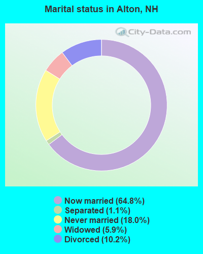
- Never married: 18.0%
- Now married: 64.8%
- Separated: 1.1%
- Widowed: 5.9%
- Divorced: 10.2%
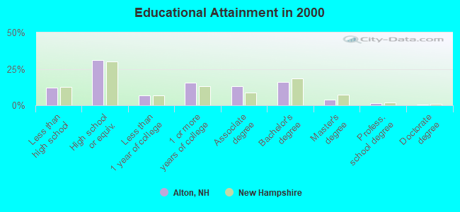
For population 25 years and over in Alton:
- High school or higher: 87.9%
- Bachelor's degree or higher: 21.5%
- Graduate or professional degree: 5.3%
- Unemployed: 3.7%
- Mean travel time to work (commute): 31.1 minutes
| Here: | 9.3 |
| New Hampshire average: | 10.9 |
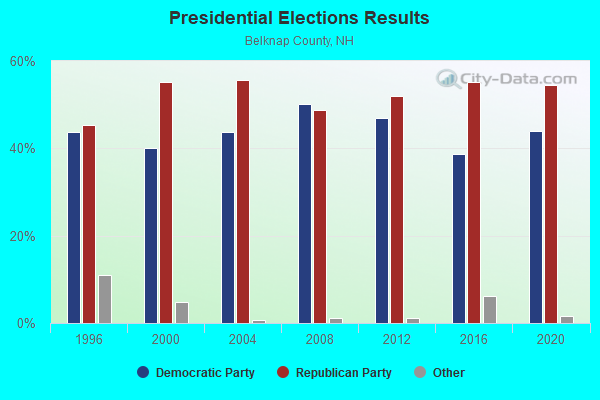
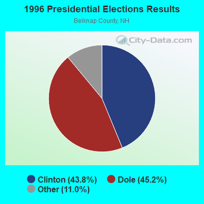


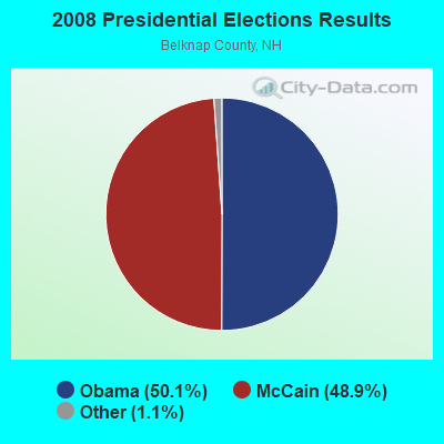
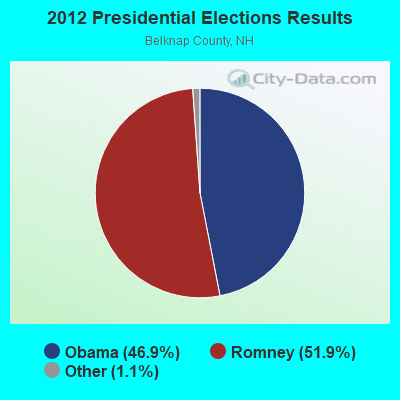
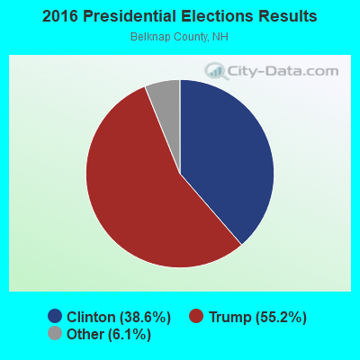
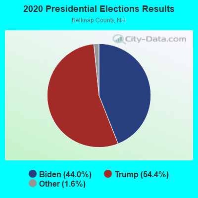
Graphs represent county-level data. Detailed 2008 Election Results
Religion statistics for Alton, NH (based on Belknap County data)
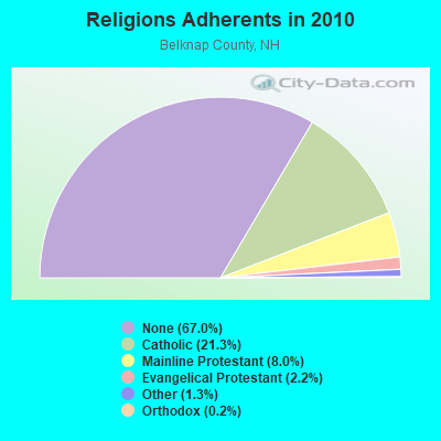
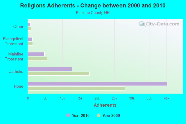
| Religion | Adherents | Congregations |
|---|---|---|
| Catholic | 12,810 | 8 |
| Mainline Protestant | 4,819 | 26 |
| Evangelical Protestant | 1,315 | 19 |
| Other | 793 | 4 |
| Orthodox | 120 | 1 |
| None | 40,231 | - |
Food Environment Statistics:
| Belknap County: | 2.46 / 10,000 pop. |
| New Hampshire: | 2.14 / 10,000 pop. |
| This county: | 0.16 / 10,000 pop. |
| State: | 0.15 / 10,000 pop. |
| Belknap County: | 1.47 / 10,000 pop. |
| New Hampshire: | 1.78 / 10,000 pop. |
| Belknap County: | 4.91 / 10,000 pop. |
| State: | 4.02 / 10,000 pop. |
| Here: | 13.10 / 10,000 pop. |
| State: | 9.70 / 10,000 pop. |
| This county: | 8.5% |
| New Hampshire: | 7.6% |
| Belknap County: | 25.0% |
| New Hampshire: | 24.4% |
| This county: | 20.8% |
| State: | 15.9% |
| Businesses in Alton, NH | ||||
| Name | Count | Name | Count | |
|---|---|---|---|---|
| Curves | 1 | MasterBrand Cabinets | 2 | |
| Dunkin Donuts | 1 | True Value | 1 | |
| FedEx | 2 | UPS | 1 | |
Strongest AM radio stations in Alton:
- WASR (1420 AM; 5 kW; WOLFEBORO, NH; Owner: RADIO WOLFEBORO, INC.)
- WGIN (930 AM; 10 kW; ROCHESTER, NH; Owner: CAPSTAR TX LIMITED PARTNERSHIP)
- WEZS (1350 AM; 5 kW; LACONIA, NH; Owner: GARY W. HAMMOND)
- WRKO (680 AM; 50 kW; BOSTON, MA; Owner: ENTERCOM BOSTON LICENSE, LLC)
- WEEI (850 AM; 50 kW; BOSTON, MA; Owner: ENTERCOM BOSTON LICENSE, LLC)
- WMTW (870 AM; 10 kW; GORHAM, ME; Owner: RADIO PARTNERS OF MAINE, L.P.)
- WCRN (830 AM; 50 kW; WORCESTER, MA; Owner: CARTER BROADCASTING CORPORATION)
- WBZ (1030 AM; 50 kW; BOSTON, MA; Owner: INFINITY BROADCASTING OPERATIONS, INC.)
- WGIR (610 AM; 5 kW; MANCHESTER, NH; Owner: CAPSTAR TX LIMITED PARTNERSHIP)
- WKOX (1200 AM; 50 kW; FRAMINGHAM, MA; Owner: CAPSTAR TX LIMITED PARTNERSHIP)
- WWZN (1510 AM; 50 kW; BOSTON, MA; Owner: ROSE CITY RADIO CORPORATION)
- WBIX (1060 AM; 40 kW; NATICK, MA; Owner: LANGER BROADCASTING CORPORATION)
- WNNZ (640 AM; 50 kW; WESTFIELD, MA; Owner: CLEAR CHANNEL BROADCASTING LICENSES, INC.)
Strongest FM radio stations in Alton:
- WMEX (106.5 FM; FARMINGTON, NH; Owner: WIMMEX, LLC)
- WLKZ (104.9 FM; WOLFEBORO, NH; Owner: TELE-MEDIA COMPANY OF NEW HAMPSHIRE, L.L.C.)
- WSCY (106.9 FM; MOULTONBOROUGH, NH; Owner: NORTHEAST COMMUNICATIONS CORPORATION)
- WNHI (93.3 FM; BELMONT, NH; Owner: CONCORD BROADCASTING, L.L.C.)
- WPKQ (103.7 FM; NORTH CONWAY, NH; Owner: CITADEL BROADCASTING COMPANY)
- WHOM (94.9 FM; MT. WASHINGTON, NH; Owner: CITADEL BROADCASTING COMPANY)
- WVFM (105.7 FM; CAMPTON, NH; Owner: DEVON BROADCASTING COMPANY, INC.)
- WMEA (90.1 FM; PORTLAND, ME; Owner: MAINE PUBLIC BROADCASTING CORPORATION)
- WPNH-FM (100.1 FM; PLYMOUTH, NH; Owner: NORTHEAST COMMUNICATIONS CORPORATION)
- WHDQ (106.1 FM; CLAREMONT, NH; Owner: GREAT NORTHERN RADIO, L.L.C.)
- WLNH-FM (98.3 FM; LACONIA, NH; Owner: WLNH RADIO, INC)
- WPHX-FM (92.1 FM; SANFORD, ME; Owner: FNX BROADCASTING LLC)
- WSEW (88.5 FM; SANFORD, ME; Owner: WORD RADIO EDUCATIONAL FOUNDATION)
- W282AF (104.3 FM; CONCORD, NH; Owner: CONCORD BIBLE FELLOWSHIP)
- WFTN-FM (94.1 FM; FRANKLIN, NH; Owner: NORTHEAST COMMUNICATIONS CORPORATION)
- WJYY (105.5 FM; CONCORD, NH; Owner: CONCORD BROADCASTING, L.L.C.)
- WVPR (89.5 FM; WINDSOR, VT; Owner: VERMONT PUBLIC RADIO)
- WBHG (101.5 FM; MEREDITH, NH; Owner: WLNH RADIO, INC)
- WBLM (102.9 FM; PORTLAND, ME; Owner: CITADEL BROADCASTING COMPANY)
- WVNH (91.1 FM; CONCORD, NH; Owner: NEW HAMPSHIRE GOSPEL RADIO, INC.)
TV broadcast stations around Alton:
- WMEA-TV (Channel 26; BIDDEFORD, ME; Owner: MAINE PUBLIC BROADCASTING CORP.)
- WMTW-TV (Channel 8; POLAND SPRING, ME; Owner: WMTW BROADCAST GROUP, LLC)
- WCSH (Channel 6; PORTLAND, ME; Owner: PACIFIC AND SOUTHERN COMPANY, INC.)
- WENH-TV (Channel 11; DURHAM, NH; Owner: UNIVERSITY OF NEW HAMPSHIRE)
- WGME-TV (Channel 13; PORTLAND, ME; Owner: WGME LICENSEE, LLC)
- WPXG (Channel 21; CONCORD, NH; Owner: PAXSON BOSTON-68 LICENSE, INC.)
- National Bridge Inventory (NBI) Statistics
- 9Number of bridges
- 30ft / 8.6mTotal length
- $28,278,000Total costs
- 32,578Total average daily traffic
- 1,870Total average daily truck traffic
- 48,211Total future (year 2042) average daily traffic
FCC Registered Cell Phone Towers:
1 (See the full list of FCC Registered Cell Phone Towers in Alton)FCC Registered Antenna Towers:
24 (See the full list of FCC Registered Antenna Towers)FCC Registered Broadcast Land Mobile Towers:
4- Police Dept Rt 11 (Lat: 43.454806 Lon: -71.220333), Call Sign: KVF490,
Assigned Frequencies: 154.830 MHz, Grant Date: 10/05/2002, Expiration Date: 11/02/2012, Cancellation Date: 01/05/2013, Registrant: Lily Pond Communications, 15 Lily Pond Rd, Gilford, NH 03249, Phone: (603) 524-3321, Fax: (603) 524-5023, Email:
- Police Dept Main St (Lat: 43.454806 Lon: -71.220333), Call Sign: KVG923,
Assigned Frequencies: 155.475 MHz, 156.090 MHz, Grant Date: 04/27/2022, Expiration Date: 07/08/2032, Registrant: Nh Dept. Of Safety/Emergency Services And Communications, 33 Hazen Dr (Mailing), Concord, NH 03305, Phone: (603) 528-7541, Fax: (603) 271-6629, Email:
- 4 Homestead Place (Lat: 43.465278 Lon: -71.244722), Call Sign: WPYQ642,
Assigned Frequencies: 151.895 MHz, 33.1400 MHz, 30.8400 MHz, 154.540 MHz, 33.4000 MHz, 154.515 MHz, 33.1600 MHz, 151.655 MHz, 151.670 MHz, 30.5800 MHz... (+26 more), Grant Date: 09/30/2003, Expiration Date: 09/30/2013, Cancellation Date: 11/30/2013, Certifier: Memile W Haddad, Registrant: Panasonic Information Systems Company, 1707 N Randall Road, E1-D9, Elgin, IL 60123-7847, Phone: (847) 468-5318, Fax: (847) 468-5331, Email:
- 229 Suncook Valley Road (Lat: 43.437111 Lon: -71.203861), Type: Upole, Structure height: 11 m, Overall height: 13 m, Call Sign: WQJY293,
Assigned Frequencies: 48.9200 MHz, 48.3200 MHz, 48.6000 MHz, 48.9800 MHz, Grant Date: 02/11/2009, Expiration Date: 02/11/2019, Cancellation Date: 02/04/2015, Certifier: Normand E Brien, Registrant: New Hampshire Electric Cooperative, Inc., 579 Tenney Mtn Hwy, Plymouth, NH 03264, Phone: (603) 536-8811, Fax: (603) 536-8687, Email:
FCC Registered Microwave Towers:
11 (See the full list of FCC Registered Microwave Towers in this town)FCC Registered Paging Towers:
1 (See the full list of FCC Registered Paging Towers)FCC Registered Amateur Radio Licenses:
34 (See the full list of FCC Registered Amateur Radio Licenses in Alton)FAA Registered Aircraft:
6- Aircraft: TAYLORCRAFT AVIATION CORP F19 (Category: Land, Seats: 2, Weight: Up to 12,499 Pounds), Engine: CONT MOTOR 0-200 SERIES (100 HP) (4 Cycle)
N-Number: 20004, N20004, N-20004, Serial Number: F-129, Year manufactured: 1978, Airworthiness Date: 09/07/1978, Certificate Issue Date: 07/18/2013
Registrant (Individual): Chester J Jr Kania, 275 New Durham Rd, Alton, NH 03809 - Aircraft: DIAMOND AIRCRAFT IND INC DA 40 (Category: Land, Seats: 4, Weight: Up to 12,499 Pounds), Engine: LYCOMING IO-360-M1A+ (180 HP) (Reciprocating)
N-Number: 461DS, N461DS, N-461DS, Serial Number: 40.761, Year manufactured: 2007, Airworthiness Date: 03/14/2007, Certificate Issue Date: 03/30/2017
Registrant (Individual): Neil A Hussey, 143 Roberts Cove Rd, Alton, NH 03809 - Aircraft: ROBINSON HELICOPTER COMPANY R44 II (Category: Land, Seats: 4, Weight: Up to 12,499 Pounds), Engine: LYCOMING IO-540-AE1A5 (260 HP) (Reciprocating)
N-Number: 558W, N558W, N-558W, Serial Number: 12299, Year manufactured: 2008, Airworthiness Date: 05/20/2008, Certificate Issue Date: 07/24/2017
Registrant (LLC): Manticore LLC, Po Box 1096, Alton, NH 03809 - Aircraft: CHAMPION 7EC (Category: Land, Seats: 2, Weight: Up to 12,499 Pounds, Speed: 90 mph), Engine: CONT MOTOR C90 SERIES (95 HP) (Reciprocating)
N-Number: 61980, N61980, N-61980, Serial Number: 7EC-703, Airworthiness Date: 05/19/1993
Registrant (Individual): Reported Sale, 278 Powder Mill Rd, Alton, NH 03809 - Aircraft: BALD ALLAN D VANS RV-8 (Category: Land, Seats: 2, Weight: Up to 12,499 Pounds), Engine: LYCOMING O-360 SERIES (180 HP) (Reciprocating)
N-Number: 663AB, N663AB, N-663AB, Serial Number: 80176, Year manufactured: 2003, Airworthiness Date: 05/24/2003, Certificate Issue Date: 03/27/2003
Registrant (Individual): Allan D Bald, 24 Miramichie Hill Rd, Alton, NH 03809 - Aircraft: MOONEY M20J (Category: Land, Seats: 4, Weight: Up to 12,499 Pounds, Speed: 126 mph), Engine: Reciprocating
N-Number: 5794F, N5794F, N-5794F, Serial Number: 24-1529, Year manufactured: 1984, Certificate Issue Date: 10/29/2012
Registrant (Individual): Robert E Gayner, Po Box 300, Alton, NH 03809
2002 - 2018 National Fire Incident Reporting System (NFIRS) incidents
- Fire incident types reported to NFIRS in Alton, NH
- 35251.1%Structure Fires
- 22632.8%Outside Fires
- 679.7%Other
- 446.4%Mobile Property/Vehicle Fires
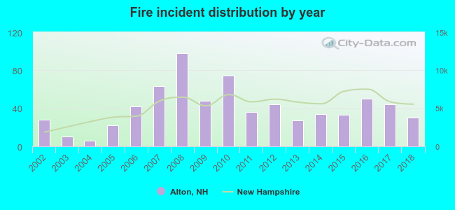 According to the data from the years 2002 - 2018 the average number of fires per year is 41. The highest number of reported fire incidents - 98 took place in 2008, and the least - 6 in 2004. The data has an increasing trend.
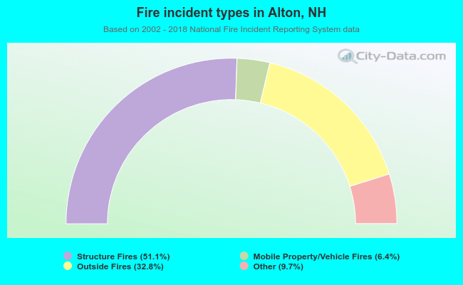 When looking into fire subcategories, the most reports belonged to: Structure Fires (51.1%), and Outside Fires (32.8%).
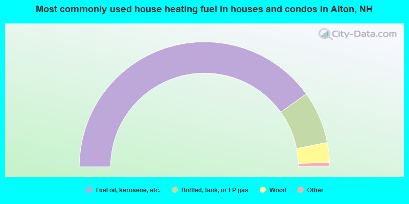
- 80.2%Fuel oil, kerosene, etc.
- 13.6%Bottled, tank, or LP gas
- 5.1%Wood
- 0.7%Utility gas
- 0.4%Electricity
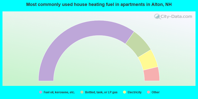
- 69.7%Fuel oil, kerosene, etc.
- 13.0%Bottled, tank, or LP gas
- 9.8%Electricity
- 3.5%Wood
- 2.6%Other fuel
- 1.4%Utility gas
Alton compared to New Hampshire state average:
- Unemployed percentage significantly below state average.
- Black race population percentage significantly below state average.
- Hispanic race population percentage significantly below state average.
- Foreign-born population percentage below state average.
- Renting percentage below state average.
- Length of stay since moving in significantly above state average.
- Number of rooms per house significantly below state average.
- House age significantly below state average.
Alton on our top lists:
- #7 on the list of "Top 101 cities with largest percentage of males in occupations: carpenters (population 5,000+)"
- #10 on the list of "Top 101 cities with largest percentage of females in industries: u. s. postal service (population 5,000+)"
- #11 on the list of "Top 101 cities with largest percentage of females in occupations: entertainers and performers, sports, and related workers (population 5,000+)"
- #23 on the list of "Top 101 cities with largest percentage of females in occupations: secondary school teachers (population 5,000+)"
- #33 on the list of "Top 101 cities with largest percentage of males in occupations: other construction workers and helpers (population 5,000+)"
- #37 on the list of "Top 101 cities with largest percentage of females in occupations: other financial specialists (population 5,000+)"
- #39 on the list of "Top 101 cities with largest percentage of males in industries: motor vehicle and parts dealers (population 5,000+)"
- #42 on the list of "Top 101 cities with the largest city-data.com crime index decrease from 2011 to 2012 (population 5,000+)"
- #43 on the list of "Top 101 cities with largest percentage of females in occupations: engineers (population 5,000+)"
- #44 on the list of "Top 101 cities with largest percentage of females in industries: printing and related support activities (population 5,000+)"
- #60 on the list of "Top 101 cities with largest percentage of males in industries: machinery, equipment, and supplies merchant wholesalers (population 5,000+)"
- #69 on the list of "Top 101 cities with the lowest number of assaults per 100,000 residents (population 5,000+)"
- #69 on the list of "Top 101 cities with largest percentage of females in industries: warehousing and storage (population 5,000+)"
- #83 on the list of "Top 101 cities with largest percentage of males in industries: publishing, and motion picture and sound recording industries (population 5,000+)"
- #85 on the list of "Top 101 cities with largest percentage of males in industries: recyclable material merchant wholesalers (population 5,000+)"
- #89 on the list of "Top 101 cities with largest percentage of females in industries: plastics and rubber products (population 5,000+)"
- #91 on the list of "Top 100 least racially diverse cities (pop. 5,000+)"
- #92 on the list of "Top 101 cities with largest percentage of females in industries: apparel (population 5,000+)"
- #94 on the list of "Top 101 cities with largest percentage of females in industries: machinery, equipment, and supplies merchant wholesalers (population 5,000+)"
- #101 on the list of "Top 101 cities with largest percentage of males in industries: metal and metal products (population 5,000+)"
- #50 on the list of "Top 101 counties with the largest increase in the number of deaths per 1000 residents 2000-2006 to 2007-2013 (pop. 50,000+)"
- #57 on the list of "Top 101 counties with the lowest total withdrawal of fresh water for public supply (pop. 50,000+)"
- #78 on the list of "Top 101 counties with the lowest Particulate Matter (PM2.5) Annual air pollution readings in 2012 (µg/m3)"

|
|
Total of 10 patent applications in 2008-2024.