Alexandria, New York
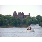
Submit your own pictures of this town and show them to the world
- OSM Map
- Google Map
- MSN Map
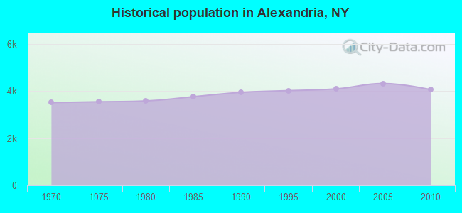
Population change since 2000: -0.9%
 |
| Males: 2,034 | |
| Females: 2,027 |
| Median resident age: | 42.8 years |
| New York median age: | 40.7 years |
Zip codes: 13607.
| Alexandria: | $55,306 |
| NY: | $79,557 |
Estimated per capita income in 2022: $32,233 (it was $16,879 in 2000)
Alexandria town income, earnings, and wages data
Estimated median house or condo value in 2022: $174,743 (it was $65,000 in 2000)
| Alexandria: | $174,743 |
| NY: | $400,400 |
Mean prices in 2022: all housing units: $208,656; detached houses: $224,125; townhouses or other attached units: $288,559; in 2-unit structures: $234,918; mobile homes: $87,861
Detailed information about poverty and poor residents in Alexandria, NY
Compare current foreclosures near Alexandria, NY:
| Photo | Address | Area | Beds / Baths | Price | Details |
|---|---|---|---|---|---|

|
#1
County Rte 25
Antwerp, NY 13608
|
1,332 sq. feet
|
1 baths 3 beds |
show details | |

|
#2
County Route 25
Antwerp, NY 13608
|
1,812 sq. feet
|
2 baths 4 beds |
show details | |

|
#3
Anthony St
Alexandria Bay, NY 13607
|
1,552 sq. feet
|
2 baths 4 beds |
show details | |

|
#4
County Route 20
Philadelphia, NY 13673
|
1,232 sq. feet
|
2 baths 3 beds |
show details | |

|
#5
County Route 25
Antwerp, NY 13608
|
1,104 sq. feet
|
1 baths 2 beds |
show details | |

|
#6
Keyser Rd
Evans Mills, NY 13637
|
1,664 sq. feet
|
2 baths 3 beds |
show details | |

|
#7
Wilder Rd
La Fargeville, NY 13656
|
1,637 sq. feet
|
1 baths 3 beds |
show details | |

|
#8
State Route 12
Clayton, NY 13624
|
1,120 sq. feet
|
1 baths 3 beds |
show details | |

|
#9
Rivershore Dr
Clayton, NY 13624
|
1,960 sq. feet
|
2 baths 3 beds |
show details | |

|
#10
State Route 26
Theresa, NY 13691
|
2,008 sq. feet
|
1 baths 2 beds |
show details |
| Photo | Address | Area | Beds / Baths | Price | Details |
|---|---|---|---|---|---|

|
#11
Pelo Rd
Clayton, NY 13624
|
1,801 sq. feet
|
1 baths 5 beds |
show details | |

|
#12
Joseph Lonsway Dr, Apt C
Clayton, NY 13624
|
- sq. feet
|
- baths - beds |
show details | |

|
#13
County Route 100a # 100
Wellesley Island, NY 13640
|
- sq. feet
|
- baths - beds |
show details | |

|
#14
Jones Rd
Hammond, NY 13646
|
552 sq. feet
|
- baths - beds |
show details | |

|
#15
Barker Rd
Antwerp, NY 13608
|
- sq. feet
|
- baths - beds |
show details | |

|
#16
Mechanic St
Antwerp, NY 13608
|
- sq. feet
|
- baths - beds |
show details | |

|
#17
Bailey Settlement Rd
La Fargeville, NY 13656
|
- sq. feet
|
- baths - beds |
show details | |

|
#18
County Route 16 # 32
Evans Mills, NY 13637
|
- sq. feet
|
- baths - beds |
show details | |

|
Check over 1 million property listings on Foreclosure.com!
|
browse all offers | |||

- 3,92196.6%White alone
- 661.6%Hispanic
- 350.9%Two or more races
- 200.5%Black alone
- 90.2%American Indian alone
- 90.2%Asian alone
- 10.02%Other race alone
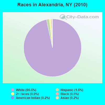
Races in Alexandria detailed stats: ancestries, foreign born residents, place of birth
According to our research of New York and other state lists, there was 1 registered sex offender living in Alexandria, New York as of May 10, 2024.
The ratio of all residents to sex offenders in Alexandria is 4,061 to 1.
The ratio of registered sex offenders to all residents in this city is much lower than the state average.
 Recent articles from our blog. Our writers, many of them Ph.D. graduates or candidates, create easy-to-read articles on a wide variety of topics.
Ancestries: German (21.7%), English (14.4%), Irish (13.7%), French (11.5%), United States (9.6%), French Canadian (6.4%).
Current Local Time: EST time zone
Incorporated in 1821
Land area: 73.0 square miles.
Population density: 56 people per square mile (very low).
80 residents are foreign born
| This town: | 2.0% |
| New York: | 20.4% |
| Alexandria town: | 2.0% ($1,332) |
| New York: | 1.9% ($2,847) |
Nearest city with pop. 50,000+: Clay, NY  (82.1 miles , pop. 58,805).
Nearest city with pop. 200,000+: Rochester, NY (117.2 miles , pop. 219,773).
Nearest city with pop. 1,000,000+: Bronx, NY (261.1 miles , pop. 1,332,650).
Nearest cities:
), )Latitude: 44.32 N, Longitude: 75.89 W
Area code commonly used in this area: 315
| Here: | 5.4% |
| New York: | 4.4% |
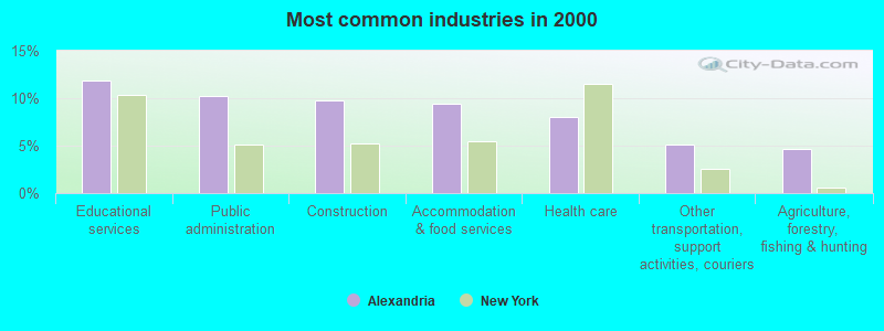
- Educational services (11.9%)
- Public administration (10.3%)
- Construction (9.8%)
- Accommodation & food services (9.5%)
- Health care (8.1%)
- Other transportation, support activities, couriers (5.2%)
- Agriculture, forestry, fishing & hunting (4.7%)
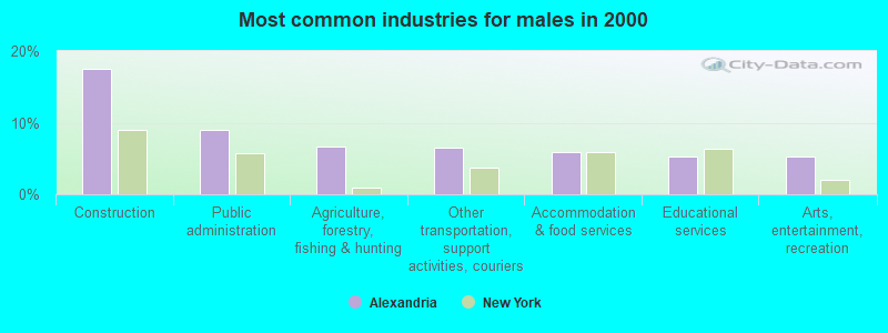
- Construction (17.5%)
- Public administration (9.0%)
- Agriculture, forestry, fishing & hunting (6.7%)
- Other transportation, support activities, couriers (6.6%)
- Accommodation & food services (5.9%)
- Educational services (5.3%)
- Arts, entertainment, recreation (5.3%)
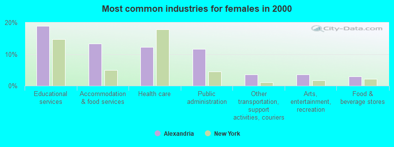
- Educational services (18.9%)
- Accommodation & food services (13.3%)
- Health care (12.2%)
- Public administration (11.6%)
- Other transportation, support activities, couriers (3.6%)
- Arts, entertainment, recreation (3.6%)
- Food & beverage stores (2.9%)
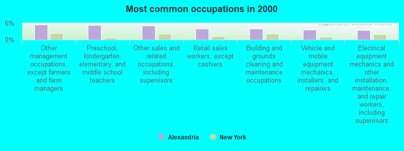
- Other management occupations, except farmers and farm managers (5.5%)
- Preschool, kindergarten, elementary, and middle school teachers (5.2%)
- Other sales and related occupations, including supervisors (5.2%)
- Retail sales workers, except cashiers (4.1%)
- Building and grounds cleaning and maintenance occupations (4.0%)
- Vehicle and mobile equipment mechanics, installers, and repairers (3.6%)
- Electrical equipment mechanics and other installation, maintenance, and repair workers, including supervisors (3.4%)
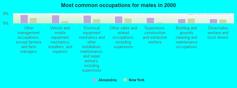
- Other management occupations, except farmers and farm managers (7.0%)
- Vehicle and mobile equipment mechanics, installers, and repairers (6.7%)
- Electrical equipment mechanics and other installation, maintenance, and repair workers, including supervisors (6.6%)
- Other sales and related occupations, including supervisors (5.8%)
- Supervisors, construction and extraction workers (4.6%)
- Building and grounds cleaning and maintenance occupations (3.7%)
- Driver/sales workers and truck drivers (3.7%)
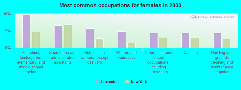
- Preschool, kindergarten, elementary, and middle school teachers (9.8%)
- Secretaries and administrative assistants (6.6%)
- Retail sales workers, except cashiers (5.6%)
- Waiters and waitresses (4.8%)
- Other sales and related occupations, including supervisors (4.5%)
- Cashiers (4.5%)
- Building and grounds cleaning and maintenance occupations (4.3%)
Average climate in Alexandria, New York
Based on data reported by over 4,000 weather stations


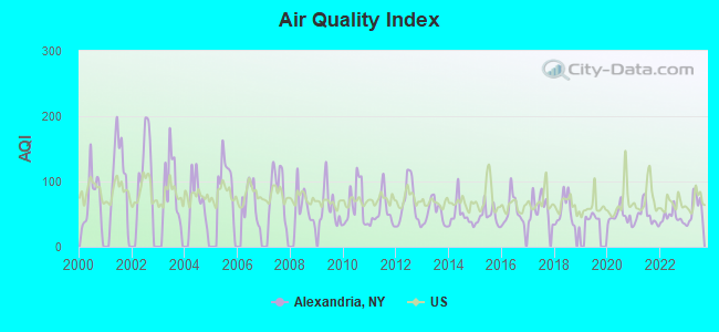
Earthquake activity:
Alexandria-area historical earthquake activity is significantly above New York state average. It is 71% smaller than the overall U.S. average.On 10/7/1983 at 10:18:46, a magnitude 5.3 (5.1 MB, 5.3 LG, 5.1 ML, Class: Moderate, Intensity: VI - VII) earthquake occurred 81.0 miles away from the city center
On 4/20/2002 at 10:50:47, a magnitude 5.3 (5.3 ML, Depth: 3.0 mi) earthquake occurred 109.2 miles away from Alexandria center
On 4/20/2002 at 10:50:47, a magnitude 5.2 (5.2 MB, 4.2 MS, 5.2 MW, 5.0 MW) earthquake occurred 108.0 miles away from the city center
On 9/25/1998 at 19:52:52, a magnitude 5.2 (4.8 MB, 4.3 MS, 5.2 LG, 4.5 MW, Depth: 3.1 mi) earthquake occurred 300.4 miles away from the city center
On 1/19/1982 at 00:14:42, a magnitude 4.7 (4.5 MB, 4.7 MD, 4.5 LG, Class: Light, Intensity: IV - V) earthquake occurred 221.2 miles away from Alexandria center
On 6/17/1991 at 08:53:16, a magnitude 4.1 (4.0 MB, 4.0 LG, Depth: 3.1 mi) earthquake occurred 131.7 miles away from the city center
Magnitude types: regional Lg-wave magnitude (LG), body-wave magnitude (MB), duration magnitude (MD), local magnitude (ML), surface-wave magnitude (MS), moment magnitude (MW)
Natural disasters:
The number of natural disasters in Jefferson County (16) is near the US average (15).Major Disasters (Presidential) Declared: 7
Emergencies Declared: 7
Causes of natural disasters: Floods: 5, Winter Storms: 4, Snowstorms: 3, Storms: 3, Hurricanes: 2, Winds: 2, Blizzard: 1, Power Outage: 1, Other: 2 (Note: some incidents may be assigned to more than one category).
Colleges/universities with over 2000 students nearest to Alexandria:
- Jefferson Community College (about 23 miles; Watertown, NY; Full-time enrollment: 2,886)
- SUNY College of Technology at Canton (about 41 miles; Canton, NY; FT enrollment: 3,411)
- St Lawrence University (about 41 miles; Canton, NY; FT enrollment: 2,501)
- Clarkson University (about 51 miles; Potsdam, NY; FT enrollment: 3,472)
- SUNY College at Potsdam (about 52 miles; Potsdam, NY; FT enrollment: 4,307)
- SUNY College at Oswego (about 69 miles; Oswego, NY; FT enrollment: 7,550)
- Le Moyne College (about 89 miles; Syracuse, NY; FT enrollment: 3,041)
Points of interest:
Notable locations in Alexandria: Harbor Island Light (A), Sunken Rock Shoal Lighthouse (B), Pullman Shoal Lighthouse (C), Comfort Shoal Lighthouse (D), Wells Island Lighthouse (E), Skinners Corners (F), Pine Tree Point Club (G), Wagoners Marina (H), Bella Vista (I), Keewaydin Marina (J), Leading Light (K), Swan Bay Marina (L), Thousand Islands Country Club (M), Bay Drive-In (N), Sunken Rock Lighthouse (O), Collins Landing Northbound Rest Area (P), Alexandria Bay Wastewater Treatment Plant (Q), Tanners Corners (R), Boldt Castle (S), Alexandria Bay Village Fire Department (T). Display/hide their locations on the map
Churches in Alexandria include: First Methodist Episcopal Church (A), Saint Cyril's Roman Catholic Church (B), Reformed Church of the Thousand Isles (C), Saint Lawrence Episcopal Church (D), Densmore Bay Church (E), Alexandria Bay Baptist Church (F), Thousand Islands Christian Church (G), Saint Paul's Lutheran Church (H). Display/hide their locations on the map
Cemeteries: Riverside Cemetery (1), Saint Cyriel Cemetery (2), Omar Cemetery (3), McDonald Cemetery (4), Barnes Cemetery (5), Hill Cemetery (6), Hinman Cemetery (7). Display/hide their locations on the map
Lakes and swamps: Mud Lake (A), Clear Lake (B), Barnett Marsh (C), Black Ash Swamp (D). Display/hide their locations on the map
Creeks: Greens Creek (A), Otter Creek (B), Cranberry Creek (C). Display/hide their locations on the map
Parks in Alexandria include: Kring Point State Park (1), Keewaydin Point State Park (2), Cranberry Creek Wildlife Management Area (3), Mary Island State Park (4). Display/hide their locations on the map
| This town: | 2.4 people |
| New York: | 2.6 people |
| This town: | 64.5% |
| Whole state: | 63.5% |
| This town: | 8.7% |
| Whole state: | 6.8% |
Likely homosexual households (counted as self-reported same-sex unmarried-partner households)
- Lesbian couples: 0.2% of all households
- Gay men: 0.2% of all households
| This town: | 13.6% |
| Whole state: | 14.6% |
| This town: | 7.2% |
| Whole state: | 7.4% |
65 people in nursing homes in 2000
For population 15 years and over in Alexandria:
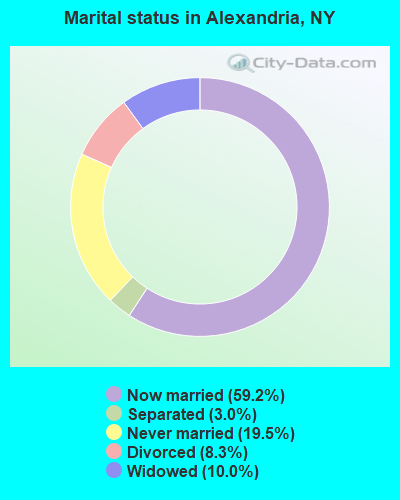
- Never married: 19.5%
- Now married: 59.2%
- Separated: 3.0%
- Widowed: 10.0%
- Divorced: 8.3%
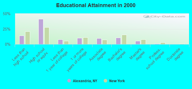
For population 25 years and over in Alexandria:
- High school or higher: 85.8%
- Bachelor's degree or higher: 17.0%
- Graduate or professional degree: 6.5%
- Unemployed: 16.9%
- Mean travel time to work (commute): 19.5 minutes
| Here: | 9.5 |
| New York average: | 14.2 |
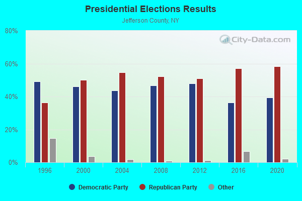
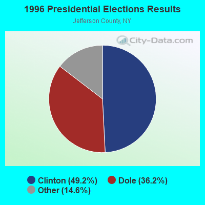
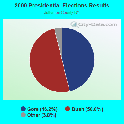
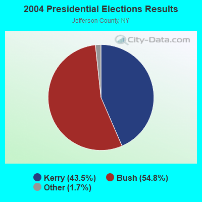
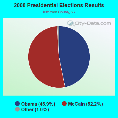
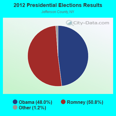
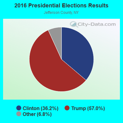
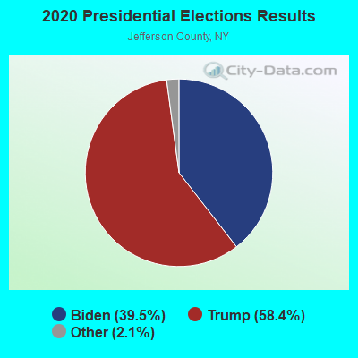
Graphs represent county-level data. Detailed 2008 Election Results
Religion statistics for Alexandria, NY (based on Jefferson County data)
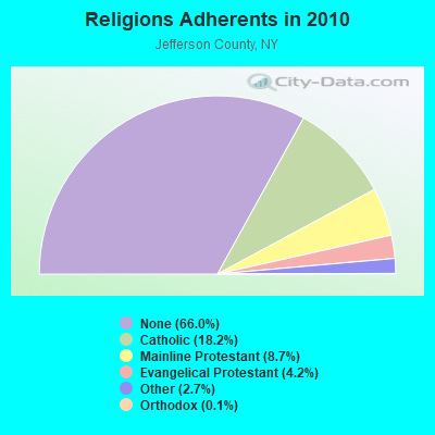
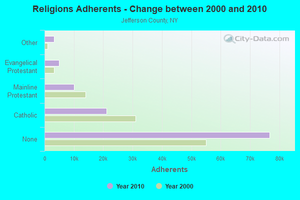
| Religion | Adherents | Congregations |
|---|---|---|
| Catholic | 21,194 | 23 |
| Mainline Protestant | 10,124 | 73 |
| Evangelical Protestant | 4,888 | 43 |
| Other | 3,176 | 8 |
| Orthodox | 140 | 1 |
| Black Protestant | 16 | 1 |
| None | 76,691 | - |
Food Environment Statistics:
| Jefferson County: | 2.37 / 10,000 pop. |
| New York: | 4.13 / 10,000 pop. |
| This county: | 0.08 / 10,000 pop. |
| State: | 0.06 / 10,000 pop. |
| Jefferson County: | 0.59 / 10,000 pop. |
| New York: | 0.92 / 10,000 pop. |
| Jefferson County: | 4.49 / 10,000 pop. |
| State: | 1.68 / 10,000 pop. |
| Here: | 9.84 / 10,000 pop. |
| State: | 8.82 / 10,000 pop. |
| This county: | 7.3% |
| New York: | 8.2% |
| Jefferson County: | 28.0% |
| New York: | 23.8% |
| This county: | 10.1% |
| State: | 15.6% |
10.06% of this county's 2021 resident taxpayers lived in other counties in 2020 ($48,837 average adjusted gross income)
| Here: | 10.06% |
| New York average: | 5.29% |
0.47% of residents moved from foreign countries ($2,248 average AGI)
Jefferson County: 0.47% New York average: 0.01%
Top counties from which taxpayers relocated into this county between 2020 and 2021:
| from St. Lawrence County, NY | |
| from Lewis County, NY | |
| from Oswego County, NY |
10.90% of this county's 2020 resident taxpayers moved to other counties in 2021 ($49,016 average adjusted gross income)
| Here: | 10.90% |
| New York average: | 6.93% |
0.34% of residents moved to foreign countries ($1,564 average AGI)
Jefferson County: 0.34% New York average: 0.02%
Top counties to which taxpayers relocated from this county between 2020 and 2021:
| to Lewis County, NY | |
| to St. Lawrence County, NY | |
| to Onondaga County, NY |
Strongest AM radio stations in Alexandria:
- WNER (1410 AM; 5 kW; WATERTOWN, NY)
- WICY (1490 AM; 50 kW; MALONE, NY; Owner: CARTIER COMMUNICATIONS INC.)
- WGY (810 AM; 50 kW; SCHENECTADY, NY; Owner: CLEAR CHANNEL BROADCASTING LICENSES, INC.)
- WHAM (1180 AM; 50 kW; ROCHESTER, NY; Owner: CITICASTERS LICENSES, L.P.)
- WCHP (760 AM; 35 kW; CHAMPLAIN, NY; Owner: CHAMPLAIN RADIO, INC.)
- WTNY (790 AM; 1 kW; WATERTOWN, NY; Owner: REGENT LICENSEE OF WATERTOWN, INC.)
- WNNZ (640 AM; 50 kW; WESTFIELD, MA; Owner: CLEAR CHANNEL BROADCASTING LICENSES, INC.)
- WPTR (1540 AM; 50 kW; ALBANY, NY; Owner: KIMTRON, INC.)
- WATN (1240 AM; 1 kW; WATERTOWN, NY; Owner: CLANCY-MANCE COMMUNICATIONS, INC)
- WMCA (570 AM; 50 kW; NEW YORK, NY; Owner: SALEM MEDIA OF NEW YORK, LLC)
- WFAN (660 AM; 50 kW; NEW YORK, NY; Owner: INFINITY BROADCASTING OPERATIONS, INC.)
- WHEN (620 AM; 5 kW; SYRACUSE, NY; Owner: CLEAR CHANNEL BROADCASTING LICENSES, INC.)
- WWKB (1520 AM; 50 kW; BUFFALO, NY; Owner: ENTERCOM BUFFALO LICENSE, LLC)
Strongest FM radio stations in Alexandria:
- WFRY-FM (97.5 FM; WATERTOWN, NY; Owner: REGENT LICENSEE OF WATERTOWN, INC.)
- WBDI (106.7 FM; COPENHAGEN, NY; Owner: FORCE COMMUNICATIONS, INC)
- WJNY (90.9 FM; WATERTOWN, NY; Owner: PUBLIC B/CNG COUNCIL CENTRAL NY, INC)
- WTOJ (103.1 FM; CARTHAGE, NY; Owner: CLANCY-MANCE COMMUNICATIONS, INC.)
- WCIZ-FM (93.3 FM; WATERTOWN, NY; Owner: REGENT LICENSEE OF WATERTOWN, INC.)
- WRVJ (91.7 FM; WATERTOWN, NY; Owner: STATE UNIVERSITY OF NEW YORK)
- WWJS (90.1 FM; WATERTOWN, NY; Owner: LIBERTY COMMUNICATIONS FAMILY B/G)
- WSLJ (88.9 FM; WATERTOWN, NY; Owner: THE ST. LAWRENCE UNIVERSITY)
- W282AH (104.3 FM; ALEXANDRIA BAY, NY; Owner: RICHARD BROOKS)
- WNCQ-FM (102.9 FM; MORRISTOWN, NY; Owner: WATERS COMMUNICATIONS INC.)
- WGIX-FM (95.3 FM; GOUVERNEUR, NY; Owner: CLANCY-MANCE COMMUNICATIONS NORTH, INC.)
- WMHI (94.7 FM; CAPE VINCENT, NY; Owner: MARS HILL BROADCASTING COMPANY INC)
- W217AE (91.3 FM; ALEXANDRIA BAY, NY; Owner: THE ST. LAWRENCE UNIVERSITY)
TV broadcast stations around Alexandria:
- WWTI (Channel 50; WATERTOWN, NY; Owner: CENTRAL NY NEWS, INC.)
- WWNY-TV (Channel 7; CARTHAGE, NY; Owner: UNITED COMMUNICATIONS CORPORATION)
- WPBS-TV (Channel 16; WATERTOWN, NY; Owner: ST. LAWRENCE VALLEY EDUCATIONAL TV COUNCIL, INC)
- WBQZ-LP (Channel 34; WATERTOWN, NY; Owner: ANTHONY DiMARCANTONIO)
- WLOT-LP (Channel 66; WATERTOWN, NY; Owner: R. ANTHONY DiMARCANTONIO)
- National Bridge Inventory (NBI) Statistics
- 20Number of bridges
- 125ft / 38.4mTotal length
- $13,863,000Total costs
- 34,844Total average daily traffic
- 5,667Total average daily truck traffic
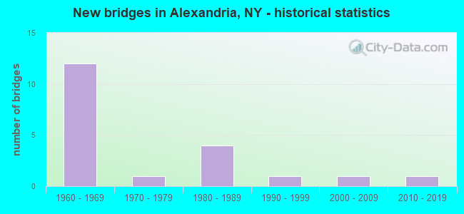
- New bridges - historical statistics
- 121960-1969
- 11970-1979
- 41980-1989
- 11990-1999
- 12000-2009
- 12010-2019
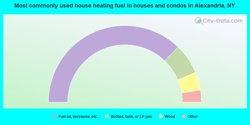
- 74.3%Fuel oil, kerosene, etc.
- 13.0%Bottled, tank, or LP gas
- 7.6%Wood
- 3.8%Electricity
- 0.6%Utility gas
- 0.5%Other fuel
- 0.2%Coal or coke
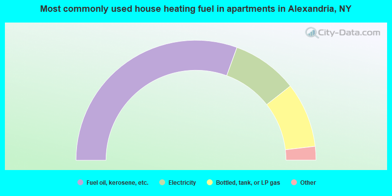
- 61.1%Fuel oil, kerosene, etc.
- 17.7%Electricity
- 17.5%Bottled, tank, or LP gas
- 3.5%Utility gas
- 0.2%Other fuel
Alexandria compared to New York state average:
- Median house value significantly below state average.
- Black race population percentage significantly below state average.
- Hispanic race population percentage significantly below state average.
- Foreign-born population percentage significantly below state average.
- Renting percentage below state average.
- Length of stay since moving in significantly above state average.
- Number of rooms per house significantly below state average.
- House age significantly below state average.
- Number of college students below state average.
- Percentage of population with a bachelor's degree or higher below state average.