Albion, Maine
Submit your own pictures of this town and show them to the world
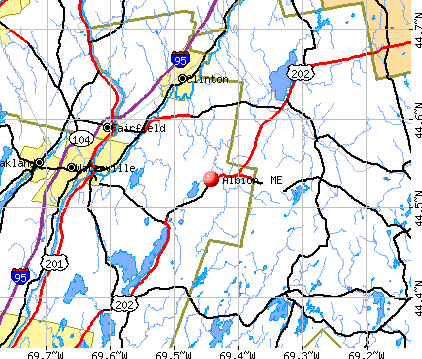
- OSM Map
- General Map
- Google Map
- MSN Map
Population change since 2000: +4.9%
 |
| Males: 1,011 | |
| Females: 1,030 |
| Median resident age: | 42.6 years |
| Maine median age: | 43.0 years |
Zip codes: 04910.
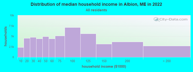
| Albion: | $60,975 |
| ME: | $69,543 |
Estimated per capita income in 2022: $30,690 (it was $15,285 in 2000)
Albion town income, earnings, and wages data
Estimated median house or condo value in 2022: $213,948 (it was $78,700 in 2000)
| Albion: | $213,948 |
| ME: | $290,600 |
Mean prices in 2022: all housing units: $236,573; detached houses: $257,878; townhouses or other attached units: $279,624; in 2-unit structures: $165,218; in 3-to-4-unit structures: $152,679; in 5-or-more-unit structures: $182,239; mobile homes: $91,490
Detailed information about poverty and poor residents in Albion, ME
Compare current foreclosures near Albion, ME:
| Photo | Address | Area | Beds / Baths | Price | Details |
|---|---|---|---|---|---|

|
#1
Hubbard St
Oakland, ME 04963
|
1,126 sq. feet
|
1 baths 1 beds |
$229,900
|
show details |

|
#2
Deer Meadow Dr
Albion, ME 04910
|
- sq. feet
|
- baths - beds |
show details | |

|
#3
Abbott Rd
Albion, ME 04910
|
- sq. feet
|
- baths - beds |
show details | |

|
#4
Crommett Dr
South China, ME 04358
|
- sq. feet
|
1 baths 2 beds |
$94,900
|
show details |

|
#5
Main St
Pittsfield, ME 04967
|
1,940 sq. feet
|
2 baths 4 beds |
show details | |

|
#6
Hill Rd
Canaan, ME 04924
|
838 sq. feet
|
1 baths 2 beds |
show details | |

|
#7
Kelsey St
Waterville, ME 04901
|
2,120 sq. feet
|
2 baths 5 beds |
show details | |

|
#8
Charles Ave
Waterville, ME 04901
|
1,139 sq. feet
|
2 baths 2 beds |
show details | |

|
#9
Park Ave
Clinton, ME 04927
|
- sq. feet
|
- baths - beds |
show details | |

|
#10
Morrison Ave Apt 2
Waterville, ME 04901
|
- sq. feet
|
- baths - beds |
show details |
| Photo | Address | Area | Beds / Baths | Price | Details |
|---|---|---|---|---|---|

|
#11
Crestwood Dr, Apt 4k
Waterville, ME 04901
|
- sq. feet
|
- baths - beds |
show details | |

|
#12
Cooper Rd
Morrill, ME 04952
|
- sq. feet
|
- baths - beds |
show details | |

|
#13
Spring St, Apt 3
Clinton, ME 04927
|
- sq. feet
|
- baths - beds |
show details | |

|
#14
Caswell Rd
Windsor, ME 04363
|
- sq. feet
|
- baths - beds |
show details | |

|
#15
Lamson Rd
Augusta, ME 04330
|
- sq. feet
|
- baths - beds |
show details | |

|
#16
Gleason Farm Rd
Oakland, ME 04963
|
- sq. feet
|
- baths - beds |
show details | |

|
#17
Main St
Vassalboro, ME 04989
|
- sq. feet
|
- baths - beds |
show details | |

|
#18
Belfast Rd
Thorndike, ME 04986
|
- sq. feet
|
- baths - beds |
show details | |

|
#19
Hill St
Oakland, ME 04963
|
- sq. feet
|
- baths - beds |
show details | |

|
#20
Axtell Dr
Oakland, ME 04963
|
- sq. feet
|
- baths - beds |
show details |
| Photo | Address | Area | Beds / Baths | Price | Details |
|---|---|---|---|---|---|

|
#21
Bellsqueeze Rd
Clinton, ME 04927
|
- sq. feet
|
- baths - beds |
show details | |

|
Check over 1 million property listings on Foreclosure.com!
|
browse all offers | |||

- 1,99297.6%White alone
- 130.6%Two or more races
- 90.4%Black alone
- 80.4%Asian alone
- 60.3%American Indian alone
- 60.3%Hispanic
- 40.2%Other race alone
- 30.1%Native Hawaiian and Other
Pacific Islander alone
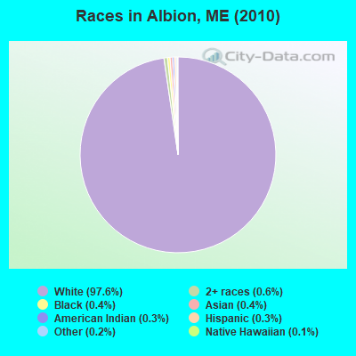
Races in Albion detailed stats: ancestries, foreign born residents, place of birth
According to our research of Maine and other state lists, there were 8 registered sex offenders living in Albion, Maine as of May 08, 2024.
The ratio of all residents to sex offenders in Albion is 255 to 1.
 Recent articles from our blog. Our writers, many of them Ph.D. graduates or candidates, create easy-to-read articles on a wide variety of topics.

 | Unity College (14 replies) |
| Albion House Close to Stream and Other Considerations (20 replies) |
| Maine weather thread (3207 replies) |
| Hard to keep horses? (17 replies) |
| Finally! A serious Maine Winter... (132 replies) |
| Portland Versus Aroostook County. (34 replies) |
Latest news from Albion, ME collected exclusively by city-data.com from local newspapers, TV, and radio stations
Ancestries: English (21.6%), French (17.9%), Irish (12.5%), United States (11.7%), French Canadian (4.2%), German (4.0%).
Current Local Time: EST time zone
Incorporated on 03/09/1804
Elevation: 311 feet
Land area: 38.9 square miles.
Population density: 53 people per square mile (very low).
41 residents are foreign born (0.9% North America, 0.6% Europe, 0.6% Asia).
| This town: | 2.1% |
| Maine: | 2.9% |
| Albion town: | 1.4% ($1,116) |
| Maine: | 1.5% ($1,417) |
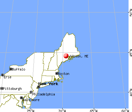
Nearest city with pop. 50,000+: Portland, ME  (71.8 miles , pop. 64,249).
Nearest city with pop. 200,000+: Boston, MA (172.9 miles , pop. 589,141).
Nearest city with pop. 1,000,000+: Bronx, NY (339.4 miles , pop. 1,332,650).
Nearest cities:
), ), ), )Latitude: 44.51 N, Longitude: 69.43 W
Area code: 207

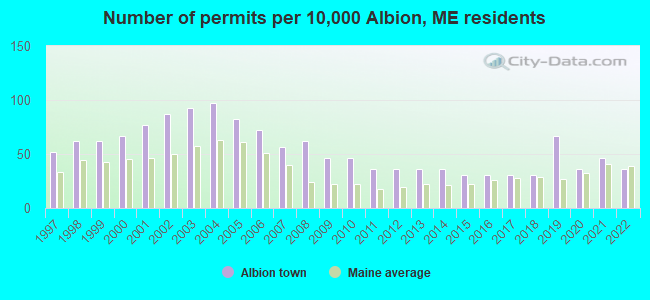
Single-family new house construction building permits:
- 2022: 7 buildings, average cost: $88,900
- 2021: 9 buildings, average cost: $88,900
- 2020: 7 buildings, average cost: $99,300
- 2019: 13 buildings, average cost: $76,800
- 2018: 6 buildings, average cost: $112,000
- 2017: 6 buildings, average cost: $112,000
- 2016: 6 buildings, average cost: $112,000
- 2015: 6 buildings, average cost: $112,000
- 2014: 7 buildings, average cost: $112,000
- 2013: 7 buildings, average cost: $112,000
- 2012: 7 buildings, average cost: $112,000
- 2011: 7 buildings, average cost: $112,000
- 2010: 9 buildings, average cost: $112,000
- 2009: 9 buildings, average cost: $112,000
- 2008: 12 buildings, average cost: $112,000
- 2007: 11 buildings, average cost: $44,000
- 2006: 14 buildings, average cost: $44,000
- 2005: 16 buildings, average cost: $44,000
- 2004: 19 buildings, average cost: $44,000
- 2003: 18 buildings, average cost: $44,000
- 2002: 17 buildings, average cost: $44,000
- 2001: 15 buildings, average cost: $44,000
- 2000: 13 buildings, average cost: $44,000
- 1999: 12 buildings, average cost: $44,000
- 1998: 12 buildings, average cost: $44,000
- 1997: 10 buildings, average cost: $44,000

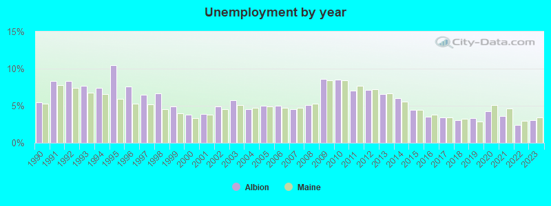
| Here: | 3.1% |
| Maine: | 3.4% |
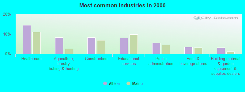
- Health care (14.4%)
- Agriculture, forestry, fishing & hunting (8.2%)
- Construction (8.2%)
- Educational services (8.0%)
- Public administration (5.5%)
- Food & beverage stores (3.4%)
- Building material & garden equipment & supplies dealers (3.1%)
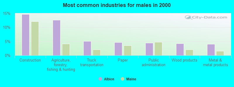
- Construction (14.7%)
- Agriculture, forestry, fishing & hunting (12.6%)
- Truck transportation (5.0%)
- Paper (4.6%)
- Public administration (4.4%)
- Wood products (4.2%)
- Metal & metal products (4.0%)
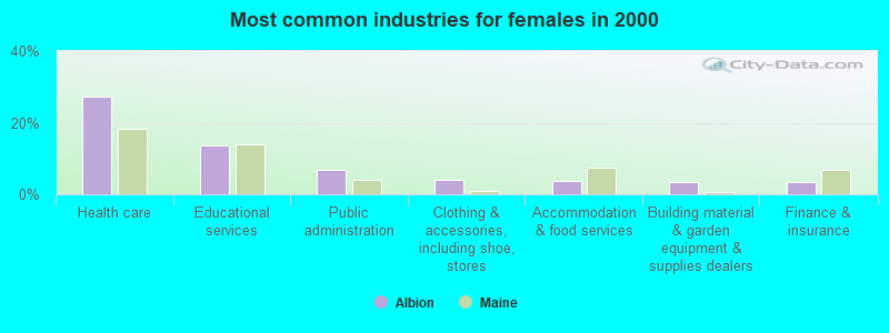
- Health care (27.3%)
- Educational services (13.6%)
- Public administration (6.8%)
- Clothing & accessories, including shoe, stores (4.0%)
- Accommodation & food services (3.8%)
- Building material & garden equipment & supplies dealers (3.5%)
- Finance & insurance (3.5%)
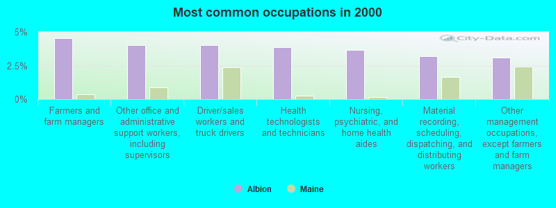
- Farmers and farm managers (4.6%)
- Other office and administrative support workers, including supervisors (4.0%)
- Driver/sales workers and truck drivers (4.0%)
- Health technologists and technicians (3.9%)
- Nursing, psychiatric, and home health aides (3.7%)
- Material recording, scheduling, dispatching, and distributing workers (3.2%)
- Other management occupations, except farmers and farm managers (3.1%)
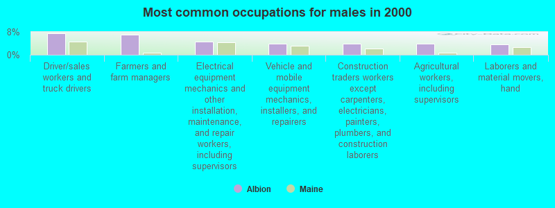
- Driver/sales workers and truck drivers (7.6%)
- Farmers and farm managers (6.9%)
- Electrical equipment mechanics and other installation, maintenance, and repair workers, including supervisors (4.6%)
- Vehicle and mobile equipment mechanics, installers, and repairers (4.0%)
- Construction traders workers except carpenters, electricians, painters, plumbers, and construction laborers (3.8%)
- Agricultural workers, including supervisors (3.8%)
- Laborers and material movers, hand (3.6%)
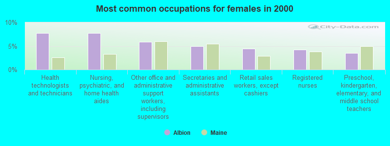
- Health technologists and technicians (7.8%)
- Nursing, psychiatric, and home health aides (7.8%)
- Other office and administrative support workers, including supervisors (5.9%)
- Secretaries and administrative assistants (4.9%)
- Retail sales workers, except cashiers (4.5%)
- Registered nurses (4.2%)
- Preschool, kindergarten, elementary, and middle school teachers (3.5%)
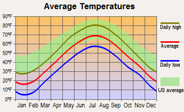
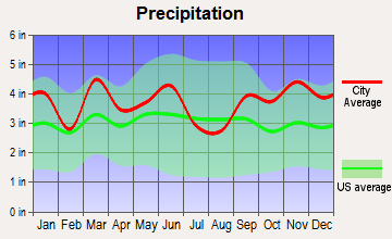
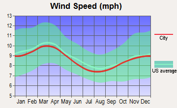
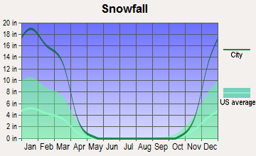
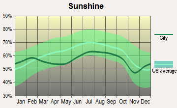
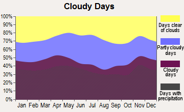
Average climate in Albion, Maine
Based on data reported by over 4,000 weather stations

Earthquake activity:
Albion-area historical earthquake activity is significantly above Maine state average. It is 78% smaller than the overall U.S. average.On 4/20/2002 at 10:50:47, a magnitude 5.3 (5.3 ML, Depth: 3.0 mi, Class: Moderate, Intensity: VI - VII) earthquake occurred 210.2 miles away from the city center
On 10/16/2012 at 23:12:25, a magnitude 4.7 (4.7 ML, Depth: 10.0 mi, Class: Light, Intensity: IV - V) earthquake occurred 87.7 miles away from Albion center
On 4/20/2002 at 10:50:47, a magnitude 5.2 (5.2 MB, 4.2 MS, 5.2 MW, 5.0 MW) earthquake occurred 211.3 miles away from the city center
On 10/7/1983 at 10:18:46, a magnitude 5.3 (5.1 MB, 5.3 LG, 5.1 ML) earthquake occurred 246.2 miles away from the city center
On 1/19/1982 at 00:14:42, a magnitude 4.7 (4.5 MB, 4.7 MD, 4.5 LG) earthquake occurred 128.5 miles away from Albion center
On 2/26/1999 at 03:38:43, a magnitude 3.8 (3.8 LG, Depth: 2.0 mi, Class: Light, Intensity: II - III) earthquake occurred 4.8 miles away from the city center
Magnitude types: regional Lg-wave magnitude (LG), body-wave magnitude (MB), duration magnitude (MD), local magnitude (ML), surface-wave magnitude (MS), moment magnitude (MW)
Natural disasters:
The number of natural disasters in Kennebec County (21) is greater than the US average (15).Major Disasters (Presidential) Declared: 16
Emergencies Declared: 4
Causes of natural disasters: Floods: 13, Storms: 11, Snows: 5, Hurricanes: 3, Heavy Rains: 2, Blizzard: 1, Ice Storm: 1, Snowfall: 1, Wind: 1, Other: 2 (Note: some incidents may be assigned to more than one category).

Hospitals and medical centers in Albion:
Other hospitals and medical centers near Albion:
- HEALTHREACH HOMECARE AND HOSPICE (Home Health Center, about 10 miles away; WATERVILLE, ME)
- WILLOWS NURSING CARE CENTER (Nursing Home, about 11 miles away; WATERVILLE, ME)
- HEALTHREACH HOSPICE (Hospital, about 11 miles away; WATERVILLE, ME)
- MOUNT ST JOSEPH NURSING HOME (Nursing Home, about 11 miles away; WATERVILLE, ME)
- OAK GROVE CENTER (Nursing Home, about 11 miles away; WATERVILLE, ME)
- INLAND HOSPITAL Acute Care Hospitals (about 12 miles away; WATERVILLE, ME)
- LAKEWOOD (Nursing Home, about 12 miles away; WATERVILLE, ME)
Colleges/universities with over 2000 students nearest to Albion:
- University of Maine at Augusta (about 22 miles; Augusta, ME; Full-time enrollment: 3,204)
- University of Maine at Farmington (about 37 miles; Farmington, ME; FT enrollment: 2,036)
- Husson University (about 39 miles; Bangor, ME; FT enrollment: 2,421)
- University of Maine (about 46 miles; Orono, ME; FT enrollment: 8,931)
- Saint Joseph's College of Maine (about 71 miles; Standish, ME; FT enrollment: 2,010)
- Southern Maine Community College (about 72 miles; South Portland, ME; FT enrollment: 4,666)
- University of Southern Maine (about 73 miles; Portland, ME; FT enrollment: 6,647)
Public elementary/middle school in Albion:
- ALBION ELEMENTARY SCHOOL (Students: 168, Location: 20 SCHOOL STREET, Grades: KG-6)
Points of interest:
Notable locations in Albion: Albion Fire Department (A), Puddledock Hall (B). Display/hide their locations on the map
Cemeteries: Abbott Cemetery (1), Quaker Hill Cemetery (2), Number Four Hill (3), Shaw Cemetery (4), Libby Cemetery (5), Lincoln Cemetery (6), Whitaker Cemetery (7). Display/hide their locations on the map
Lakes and reservoirs: Lovejoy Pond (A), Mill Stream (B). Display/hide their locations on the map
Streams, rivers, and creeks: Yorktown Brook (A), Mill Stream (B), Pratt Stream (C), Fowler Brook (D). Display/hide their locations on the map
Birthplace of: Owen Lovejoy - Politician.
Drinking water stations with addresses in Albion and their reported violations in the past:
FIELD OF GREENS (Population served: 250, Groundwater):Past health violations:LOVEJOY HEALTH CENTER (Population served: 60, Groundwater):Past monitoring violations:
- MCL, Monthly (TCR) - In JUL-2009, Contaminant: Coliform. Follow-up actions: St Public Notif requested (JUL-31-2009), St Formal NOV issued (JUL-31-2009), St Public Notif received (AUG-10-2009), St Intentional no-action (SEP-09-2011), St Compliance achieved (SEP-09-2011)
- MCL, Monthly (TCR) - In OCT-2006, Contaminant: Coliform. Follow-up actions: St Public Notif requested (NOV-02-2006), St Violation/Reminder Notice (NOV-02-2006), St AO (w/o penalty) issued (MAR-23-2007), St Compliance achieved (MAR-31-2007), St Public Notif received (2 times from APR-05-2007 to APR-05-2007)
- MCL, Monthly (TCR) - In AUG-2006, Contaminant: Coliform. Follow-up actions: St Public Notif requested (SEP-01-2006), St Violation/Reminder Notice (SEP-01-2006), St AO (w/o penalty) issued (MAR-23-2007), St Compliance achieved (MAR-31-2007), St Public Notif received (2 times from APR-05-2007 to APR-05-2007)
- MCL, Monthly (TCR) - In JUN-2006, Contaminant: Coliform. Follow-up actions: St Public Notif requested (JUN-30-2006), St Violation/Reminder Notice (JUN-30-2006), St AO (w/o penalty) issued (MAR-23-2007), St Compliance achieved (MAR-31-2007), St Public Notif received (2 times from APR-05-2007 to APR-05-2007)
- 4 routine major monitoring violations
Past monitoring violations:
- One routine major monitoring violation
- One regular monitoring violation
| This town: | 2.5 people |
| Maine: | 2.3 people |
| This town: | 69.4% |
| Whole state: | 62.9% |
| This town: | 9.6% |
| Whole state: | 9.4% |
Likely homosexual households (counted as self-reported same-sex unmarried-partner households)
- Lesbian couples: 0.2% of all households
- Gay men: 0.5% of all households
| This town: | 12.0% |
| Whole state: | 10.9% |
| This town: | 5.2% |
| Whole state: | 4.1% |
For population 15 years and over in Albion:
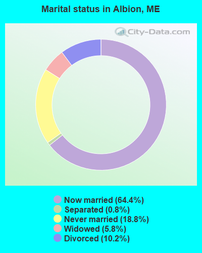
- Never married: 18.8%
- Now married: 64.4%
- Separated: 0.8%
- Widowed: 5.8%
- Divorced: 10.2%
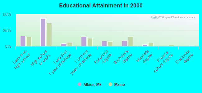
For population 25 years and over in Albion:
- High school or higher: 84.1%
- Bachelor's degree or higher: 12.6%
- Graduate or professional degree: 3.7%
- Unemployed: 5.8%
- Mean travel time to work (commute): 27.6 minutes
| Here: | 10.0 |
| Maine average: | 11.2 |
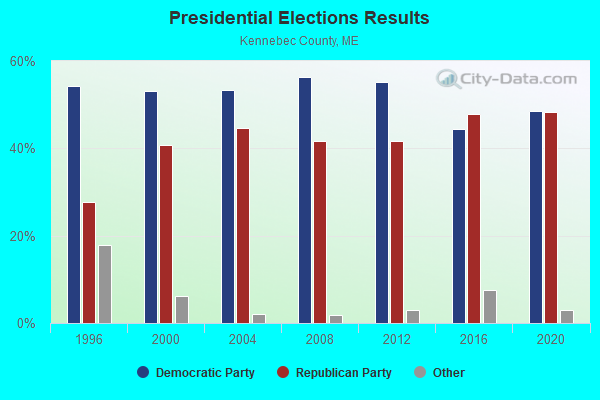
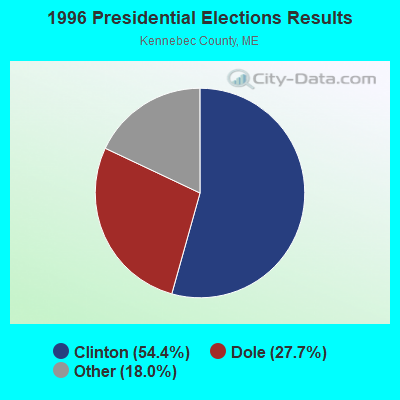
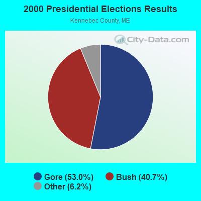
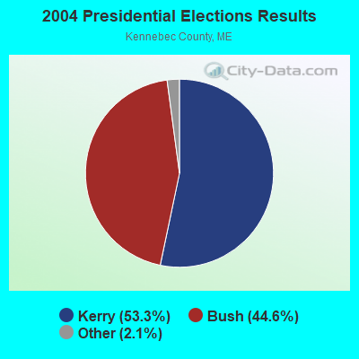
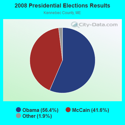
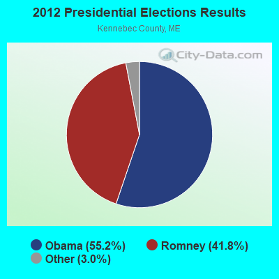
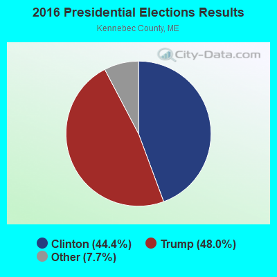
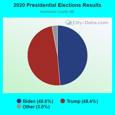
Graphs represent county-level data. Detailed 2008 Election Results
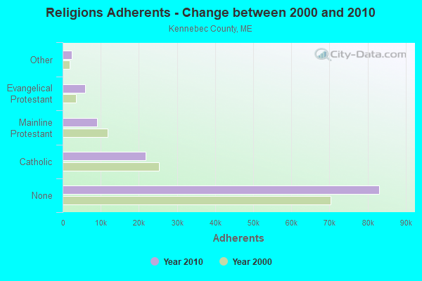
Religion statistics for Albion, ME (based on Kennebec County data)
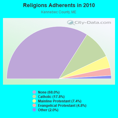
| Religion | Adherents | Congregations |
|---|---|---|
| Catholic | 21,758 | 11 |
| Mainline Protestant | 8,999 | 60 |
| Evangelical Protestant | 5,829 | 56 |
| Other | 2,466 | 17 |
| None | 83,099 | - |
Food Environment Statistics:
| Kennebec County: | 1.99 / 10,000 pop. |
| Maine: | 2.80 / 10,000 pop. |
| This county: | 0.17 / 10,000 pop. |
| State: | 0.14 / 10,000 pop. |
| Kennebec County: | 1.41 / 10,000 pop. |
| Maine: | 2.20 / 10,000 pop. |
| Kennebec County: | 6.38 / 10,000 pop. |
| State: | 5.75 / 10,000 pop. |
| Here: | 8.70 / 10,000 pop. |
| State: | 11.02 / 10,000 pop. |
| This county: | 8.6% |
| Maine: | 8.2% |
| Kennebec County: | 28.2% |
| Maine: | 25.0% |
Strongest AM radio stations in Albion:
- WSKW (1160 AM; 10 kW; SKOWHEGAN, ME; Owner: MOUNTAIN WIRELESS, INCORPORATED)
- WTVL (1490 AM; 1 kW; WATERVILLE, ME; Owner: CITADEL BROADCASTING COMPANY)
- WFAU (1280 AM; 5 kW; GARDINER, ME; Owner: CAPSTAR TX LIMITED PARTNERSHIP)
- WZON (620 AM; 5 kW; BANGOR, ME; Owner: THE ZONE CORPORATION)
- WTME (780 AM; 10 kW; RUMFORD, ME; Owner: MOUNTAIN VALLEY BROADCASTING, INC.)
- WABI (910 AM; 5 kW; BANGOR, ME; Owner: CLEAR CHANNEL BROADCASTING LICENSES, INC.)
- WRKO (680 AM; 50 kW; BOSTON, MA; Owner: ENTERCOM BOSTON LICENSE, LLC)
- WMTW (870 AM; 10 kW; GORHAM, ME; Owner: RADIO PARTNERS OF MAINE, L.P.)
- WEEI (850 AM; 50 kW; BOSTON, MA; Owner: ENTERCOM BOSTON LICENSE, LLC)
- WMDR (1340 AM; 1 kW; AUGUSTA, ME; Owner: LIGHT OF LIFE MINISTRIES, INC.)
- WBZ (1030 AM; 50 kW; BOSTON, MA; Owner: INFINITY BROADCASTING OPERATIONS, INC.)
- WDEA (1370 AM; 5 kW; ELLSWORTH, ME; Owner: CUMULUS LICENSING CORP.)
- WGAN (560 AM; 5 kW; PORTLAND, ME; Owner: SAGA COMMUNICATIONS OF NEW ENGLAND, LLC)
Strongest FM radio stations in Albion:
- WWWA (95.3 FM; WINSLOW, ME; Owner: LIGHT OF LIFE MINISTRIES, INC.)
- WWBX (97.1 FM; BANGOR, ME; Owner: CLEAR CHANNEL BROADCASTING LICENSES, INC.)
- WMEP (90.5 FM; CAMDEN, ME; Owner: MAINE PUBLIC BROADCASTING CORP.)
- WQSS (102.5 FM; CAMDEN, ME; Owner: CLEAR CHANNEL BROADCASTING LICENSES, INC.)
- WEBB (98.5 FM; WATERVILLE, ME; Owner: CITADEL BROADCASTING COMPANY)
- WCTB (93.5 FM; FAIRFIELD, ME; Owner: MOUNTAIN WIRELESS, INC.)
- WBFB (104.7 FM; BELFAST, ME; Owner: CLEAR CHANNEL BROADCASTING LICENSES, INC.)
- WHQO (107.9 FM; SKOWHEGAN, ME; Owner: MOUNTAIN WIRELESS, INC.)
- WMEW (91.3 FM; WATERVILLE, ME; Owner: MAINE PUBLIC BROADCASTING CORPORATION)
- WFZX (101.7 FM; SEARSPORT, ME; Owner: CLEAR CHANNEL BROADCASTING LICENSES, INC.)
- WTOS-FM (105.1 FM; SKOWHEGAN, ME; Owner: CAPSTAR TX LIMITED PARTNERSHIP)
- WMME-FM (92.3 FM; AUGUSTA, ME; Owner: CITADEL BROADCASTING COMPANY)
- WMCM (103.3 FM; ROCKLAND, ME; Owner: CLEAR CHANNEL BROADCASTING LICENSES, INC.)
- WQCB (106.5 FM; BREWER, ME; Owner: CUMULUS LICENSING CORP.)
- WKIT-FM (100.3 FM; BREWER, ME; Owner: THE ZONE CORPORATION)
- WWMJ (95.7 FM; ELLSWORTH, ME; Owner: CUMULUS LICENSING CORP.)
- WBQX (106.9 FM; THOMASTON, ME; Owner: MARINER BROADCASTING LIMITED PARTNER)
- WERU-FM (89.9 FM; BLUE HILL, ME; Owner: SALT POND COMMUNITY B/C COMPANY)
- WGUY (102.1 FM; DEXTER, ME; Owner: CONCORD MEDIA GROUP, INC.)
- WABK-FM (104.3 FM; GARDINER, ME; Owner: CAPSTAR TX LIMITED PARTNERSHIP)
TV broadcast stations around Albion:
- WABI-TV (Channel 5; BANGOR, ME; Owner: COMMUNITY BROADCASTING SERVICE)
- WFYW-LP (Channel 69; FAIRFIELD/WATERVILLE, ME; Owner: THREE ANGELS BROADCASTING NETWORK, INC.)
- DW23AB (Channel 23; WATERVILLE, ME; Owner: RUSSELL COMMUNICATIONS)
- W36CK (Channel 36; BANGOR, ME; Owner: TRINITY BROADCASTING NETWORK)
- WGCI-LP (Channel 4; WATERVILLE, ME; Owner: PACIFIC AND SOUTHERN COMPANY, INC.)
- Albion, Maine
- Fatal accident count13
- Vehicles involved in fatal accidents18
- Fatal accidents involving drunk persons:5
- Fatalities13
- Persons involved in fatal accidents30
- Pedestrians involved in fatal accidents1
- Maine average
- Fatal accident count1883
- Vehicles involved in fatal accidents2641
- Fatal accidents involving drunk persons721
- Fatalities2080
- Persons involved in fatal accidents4472
- Pedestrians involved in fatal accidents149
- National Bridge Inventory (NBI) Statistics
- 6Number of bridges
- 151ft / 46.0mTotal length
- 412,399Total average daily traffic
- 20,618Total average daily truck traffic
- 14,906Total future (year 2036) average daily traffic
FCC Registered Antenna Towers:
19 (See the full list of FCC Registered Antenna Towers in Albion)FCC Registered Broadcast Land Mobile Towers:
3- State Highway 9 (Lat: 44.502278 Lon: -69.502250), Call Sign: KZJ912,
Assigned Frequencies: 155.925 MHz, Grant Date: 12/12/1995, Expiration Date: 02/07/2001, Cancellation Date: 04/15/2001, Registrant: Albion, Town Of, Albion, ME 04910
- 22 Unity Road (Lat: 44.537944 Lon: -69.434722), Call Sign: WQEL716,
Assigned Frequencies: 159.907 MHz, Grant Date: 03/01/2006, Expiration Date: 03/01/2016, Cancellation Date: 05/07/2016, Certifier: Shawn J Esler Mr., Registrant: Yankee Communications, 56 Albion Road, Benton, ME 04901, Phone: (207) 453-2000
- Lat: 44.513944 Lon: -69.434778, Call Sign: WQTF224,
Assigned Frequencies: 155.332 MHz, Grant Date: 01/23/2024, Expiration Date: 01/22/2034, Certifier: Andy Clark, Registrant: Yankee Ct Inc, 263 Neck Road, Benton, ME 04901, Phone: (207) 453-2000, Fax: (866) 536-5243, Email:
FCC Registered Microwave Towers:
2- Albion, 20 Hussey Road (Lat: 44.524333 Lon: -69.437222), Type: Mtower, Structure height: 55.5 m, Overall height: 56.7 m, Call Sign: WQRD211,
Assigned Frequencies: 11305.0 MHz, 19425.0 MHz, 11305.0 MHz, 19425.0 MHz, 11305.0 MHz, 19425.0 MHz, 11305.0 MHz, 19425.0 MHz, 11305.0 MHz, 19425.0 MHz... (+8 more), Grant Date: 04/18/2013, Expiration Date: 04/18/2023, Cancellation Date: 09/17/2020, Certifier: Jessica B Lyons, Registrant: At&t Services, Inc., 208 S. Akard Street, Room 2100, Dallas, TX 75202, Phone: (855) 699-7073, Email:
- South Albion, Rustic Lane (371950) (Lat: 44.494083 Lon: -69.511222), Type: Mtower, Structure height: 55.5 m, Call Sign: WQRD242,
Assigned Frequencies: 11265.0 MHz, 11505.0 MHz, 17865.0 MHz, 11265.0 MHz, 11505.0 MHz, 17865.0 MHz, 11265.0 MHz, 11505.0 MHz, 17865.0 MHz, 11265.0 MHz... (+35 more), Grant Date: 04/18/2013, Expiration Date: 04/18/2023, Cancellation Date: 09/17/2020, Certifier: Jessica B Lyons, Registrant: At&t Services, Inc., 208 S. Akard St., Room 2100, Dallas, TX 75202, Phone: (855) 699-7073, Email:
FCC Registered Amateur Radio Licenses:
30 (See the full list of FCC Registered Amateur Radio Licenses in Albion)FAA Registered Aircraft:
1- Aircraft: CESSNA 180 (Category: Land, Seats: 4, Weight: Up to 12,499 Pounds, Speed: 121 mph), Engine: CONT MOTOR O-470 SERIES (230 HP) (Reciprocating)
N-Number: 9104C, N9104C, N-9104C, Serial Number: 31203, Year manufactured: 1954, Airworthiness Date: 11/10/1955, Certificate Issue Date: 09/01/1992
Registrant (Individual): Harold H Perkins, 256 Bog Rd, Albion, ME 04910
2003 - 2018 National Fire Incident Reporting System (NFIRS) incidents
- Fire incident types reported to NFIRS in Albion, ME
- 14661.6%Structure Fires
- 5724.1%Outside Fires
- 2410.1%Mobile Property/Vehicle Fires
- 104.2%Other
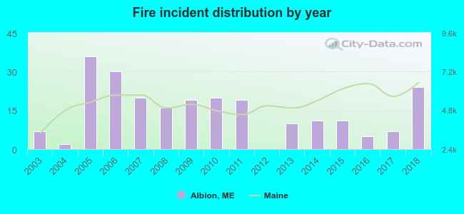 Based on the data from the years 2003 - 2018 the average number of fires per year is 15. The highest number of reported fires - 36 took place in 2005, and the least - 0 in 2012. The data has an increasing trend.
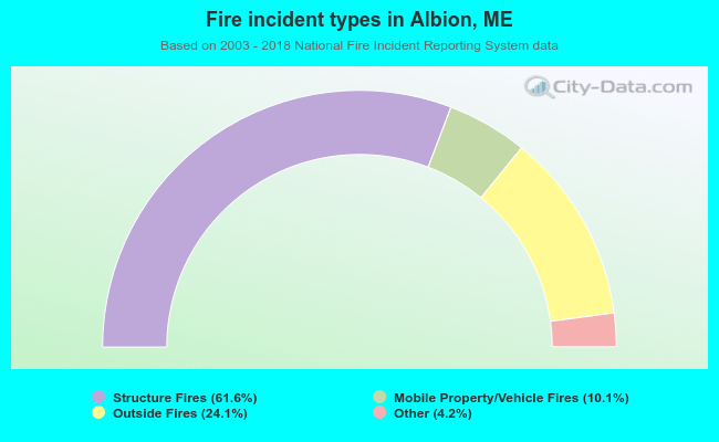 When looking into fire subcategories, the most reports belonged to: Structure Fires (61.6%), and Outside Fires (24.1%).
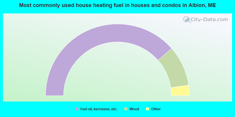
- 77.1%Fuel oil, kerosene, etc.
- 18.2%Wood
- 3.2%Bottled, tank, or LP gas
- 0.9%Electricity
- 0.3%Coal or coke
- 0.3%Solar energy

- 73.5%Fuel oil, kerosene, etc.
- 10.8%Wood
- 6.0%Bottled, tank, or LP gas
- 6.0%Electricity
- 3.6%Other fuel
Albion compared to Maine state average:
- Unemployed percentage below state average.
- Black race population percentage significantly below state average.
- Hispanic race population percentage significantly below state average.
- Foreign-born population percentage below state average.
- Renting percentage below state average.
- Length of stay since moving in significantly above state average.
- Number of rooms per house significantly below state average.
- House age significantly below state average.
- Percentage of population with a bachelor's degree or higher below state average.

|
Total of 1 patent application in 2008-2024.