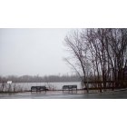
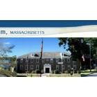
Agawam, Massachusetts
Submit your own pictures of this city and show them to the world
- OSM Map
- General Map
- Google Map
- MSN Map
Population change since 2000: +1.7%
 |
| Males: 13,593 | |
| Females: 15,023 |
| Median resident age: | 40.3 years |
| Massachusetts median age: | 36.5 years |
Zip codes: 01030.
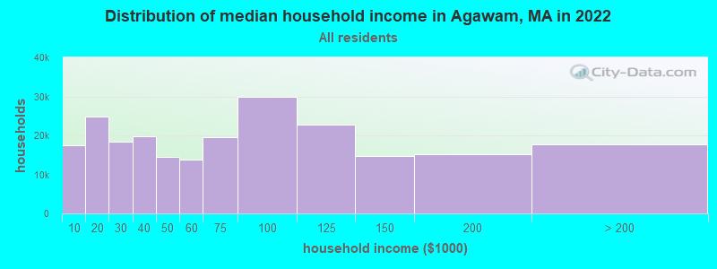
| Agawam: | $79,418 |
| MA: | $94,488 |
Estimated per capita income in 2022: $39,591 (it was $22,562 in 2000)
Agawam city income, earnings, and wages data
Estimated median house or condo value in 2022: $319,316 (it was $128,700 in 2000)
| Agawam: | $319,316 |
| MA: | $534,700 |
Mean prices in 2022: all housing units: $315,253; detached houses: $334,901; townhouses or other attached units: $238,289; in 2-unit structures: $223,248; in 3-to-4-unit structures: $195,645; in 5-or-more-unit structures: $166,405; mobile homes: $156,908
Detailed information about poverty and poor residents in Agawam, MA


- 26,87195.5%White alone
- 5141.8%Hispanic
- 2721.0%Asian alone
- 2490.9%Black alone
- 1820.6%Two or more races
- 400.1%American Indian alone
- 140.05%Other race alone
- 20.01%Native Hawaiian and Other
Pacific Islander alone
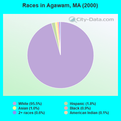
Races in Agawam detailed stats: ancestries, foreign born residents, place of birth
According to our research of Massachusetts and other state lists, there were 15 registered sex offenders living in Agawam, Massachusetts as of May 07, 2024.
The ratio of all residents to sex offenders in Agawam is 1,908 to 1.
The ratio of registered sex offenders to all residents in this city is lower than the state average.
Type |
2009 |
2010 |
2011 |
2012 |
2013 |
2014 |
2015 |
2016 |
2017 |
2018 |
2019 |
2020 |
2021 |
2022 |
|---|---|---|---|---|---|---|---|---|---|---|---|---|---|---|
| Murders (per 100,000) | 0 (0.0) | 0 (0.0) | 0 (0.0) | 0 (0.0) | 0 (0.0) | 0 (0.0) | 0 (0.0) | 0 (0.0) | 0 (0.0) | 0 (0.0) | 0 (0.0) | 0 (0.0) | 0 (0.0) | 0 (0.0) |
| Rapes (per 100,000) | 4 (13.9) | 6 (21.1) | 6 (21.0) | 5 (17.4) | 12 (41.9) | 12 (41.7) | 13 (45.1) | 10 (34.7) | 3 (10.4) | 14 (48.4) | 13 (45.2) | 11 (38.6) | 10 (34.8) | 12 (42.1) |
| Robberies (per 100,000) | 9 (31.3) | 5 (17.6) | 3 (10.5) | 5 (17.4) | 3 (10.5) | 4 (13.9) | 5 (17.3) | 7 (24.3) | 9 (31.2) | 12 (41.4) | 8 (27.8) | 4 (14.0) | 6 (20.9) | 5 (17.5) |
| Assaults (per 100,000) | 48 (166.8) | 36 (126.6) | 33 (115.3) | 24 (83.6) | 26 (90.7) | 36 (125.1) | 58 (201.0) | 64 (221.9) | 54 (187.2) | 79 (272.8) | 61 (212.3) | 52 (182.2) | 82 (285.1) | 85 (297.9) |
| Burglaries (per 100,000) | 69 (239.7) | 75 (263.7) | 55 (192.2) | 108 (376.2) | 105 (366.4) | 146 (507.5) | 195 (675.8) | 173 (599.8) | 178 (617.2) | 142 (490.4) | 133 (462.8) | 115 (403.0) | 70 (243.4) | 160 (560.7) |
| Thefts (per 100,000) | 181 (628.9) | 155 (545.0) | 114 (398.4) | 140 (487.7) | 131 (457.1) | 204 (709.1) | 296 (1,026) | 284 (984.6) | 314 (1,089) | 268 (925.6) | 230 (800.4) | 164 (574.8) | 179 (622.5) | 250 (876.1) |
| Auto thefts (per 100,000) | 33 (114.7) | 30 (105.5) | 30 (104.9) | 24 (83.6) | 35 (122.1) | 24 (83.4) | 34 (117.8) | 32 (110.9) | 28 (97.1) | 18 (62.2) | 15 (52.2) | 21 (73.6) | 22 (76.5) | 34 (119.1) |
| Arson (per 100,000) | 2 (6.9) | 7 (24.6) | 5 (17.5) | 0 (0.0) | 1 (3.5) | 3 (10.4) | 1 (3.5) | 2 (6.9) | 3 (10.4) | 0 (0.0) | 1 (3.5) | 2 (7.0) | 3 (10.4) | 1 (3.5) |
| City-Data.com crime index | 105.0 | 96.2 | 80.8 | 88.4 | 108.5 | 133.1 | 179.2 | 169.6 | 149.7 | 182.0 | 155.6 | 128.6 | 139.2 | 182.3 |
The City-Data.com crime index weighs serious crimes and violent crimes more heavily. Higher means more crime, U.S. average is 246.1. It adjusts for the number of visitors and daily workers commuting into cities.
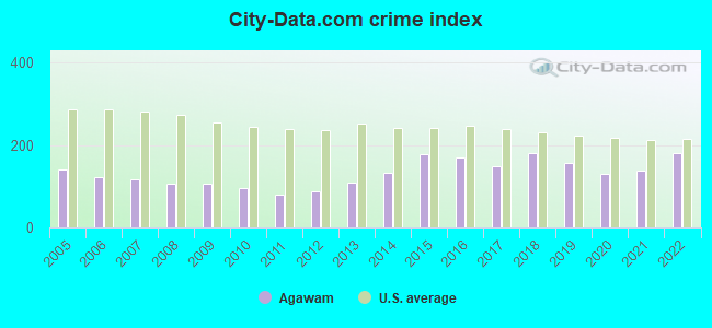
Crime rate in Agawam detailed stats: murders, rapes, robberies, assaults, burglaries, thefts, arson
Full-time law enforcement employees in 2021, including police officers: 60 (47 officers - 44 male; 3 female).
| Officers per 1,000 residents here: | 1.63 |
| Massachusetts average: | 2.53 |
 Recent articles from our blog. Our writers, many of them Ph.D. graduates or candidates, create easy-to-read articles on a wide variety of topics.

 | Ipswich - Senior Housing/Agawam Village (19 replies) |
| Nice areas of Agawam MA (4 replies) |
| Nice Neighborhoods Near Springfield (108 replies) |
| Relocating from Texas for child with autism (54 replies) |
| How is downtown Springfield? (140 replies) |
| Relocating to Massachusetts from Dublin (11 replies) |
Latest news from Agawam, MA collected exclusively by city-data.com from local newspapers, TV, and radio stations
Ancestries: Italian (23.6%), Irish (20.4%), French (17.2%), Polish (12.8%), English (10.6%), French Canadian (10.3%).
Current Local Time: EST time zone
Elevation: 90 feet
Land area: 23.2 square miles.
Population density: 1,231 people per square mile (low).
1,502 residents are foreign born (3.1% Europe, 1.1% Asia, 0.8% North America).
| This city: | 5.3% |
| Massachusetts: | 12.2% |
| Agawam city: | 1.4% ($1,832) |
| Massachusetts: | 1.3% ($2,336) |
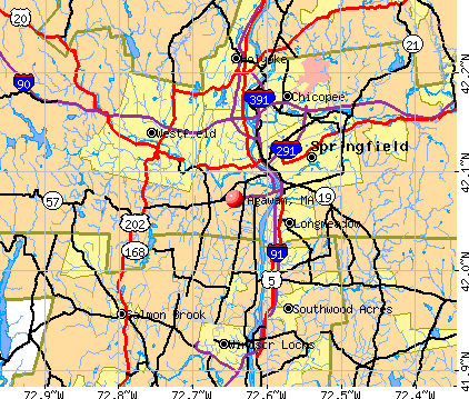
Nearest city with pop. 50,000+: Springfield, MA  (5.7 miles , pop. 152,082).
Nearest city with pop. 200,000+: Boston, MA (81.5 miles , pop. 589,141).
Nearest city with pop. 1,000,000+: Bronx, NY (106.0 miles , pop. 1,332,650).
Nearest cities:
), ), ), ), ), Latitude: 42.07 N, Longitude: 72.64 W
Daytime population change due to commuting: -4,423 (-15.7%)
Workers who live and work in this city: 3,600 (24.5%)
Area code commonly used in this area: 413
Property values in Agawam, MA

Agawam tourist attractions:
Agawam, Massachusetts accommodation & food services, waste management - Economy and Business Data
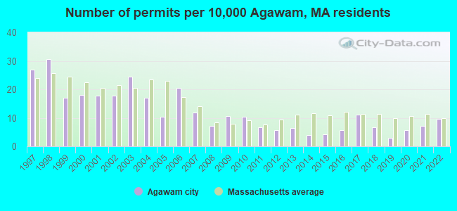
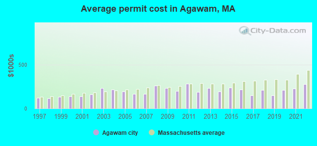
Single-family new house construction building permits:
- 2022: 27 buildings, average cost: $276,300
- 2021: 20 buildings, average cost: $228,700
- 2020: 16 buildings, average cost: $211,400
- 2019: 8 buildings, average cost: $151,600
- 2018: 19 buildings, average cost: $208,200
- 2017: 31 buildings, average cost: $148,200
- 2016: 16 buildings, average cost: $217,300
- 2015: 12 buildings, average cost: $237,500
- 2014: 11 buildings, average cost: $194,400
- 2013: 18 buildings, average cost: $230,600
- 2012: 16 buildings, average cost: $188,700
- 2011: 19 buildings, average cost: $281,300
- 2010: 29 buildings, average cost: $199,300
- 2009: 30 buildings, average cost: $232,600
- 2008: 20 buildings, average cost: $258,600
- 2007: 33 buildings, average cost: $167,800
- 2006: 58 buildings, average cost: $167,200
- 2005: 29 buildings, average cost: $195,700
- 2004: 48 buildings, average cost: $216,400
- 2003: 69 buildings, average cost: $229,500
- 2002: 50 buildings, average cost: $157,800
- 2001: 50 buildings, average cost: $138,900
- 2000: 51 buildings, average cost: $136,400
- 1999: 48 buildings, average cost: $132,600
- 1998: 86 buildings, average cost: $117,600
- 1997: 76 buildings, average cost: $118,900
| Here: | 4.4% |
| Massachusetts: | 3.5% |
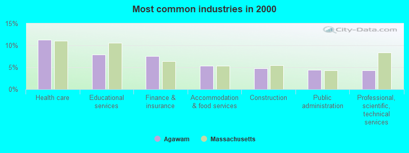
- Health care (11.3%)
- Educational services (7.9%)
- Finance & insurance (7.5%)
- Accommodation & food services (5.3%)
- Construction (4.8%)
- Public administration (4.4%)
- Professional, scientific, technical services (4.3%)
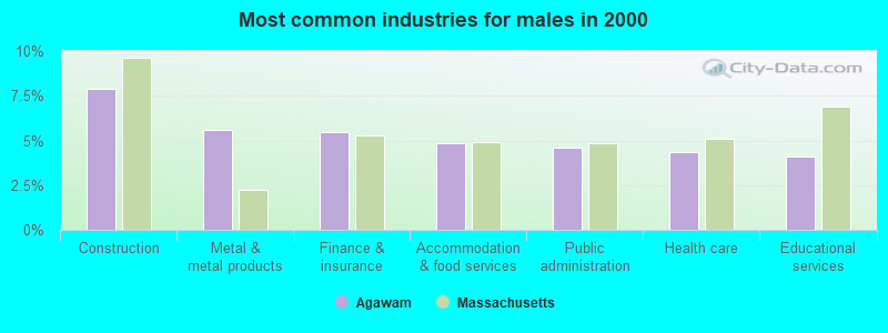
- Construction (7.9%)
- Metal & metal products (5.6%)
- Finance & insurance (5.5%)
- Accommodation & food services (4.9%)
- Public administration (4.6%)
- Health care (4.3%)
- Educational services (4.1%)
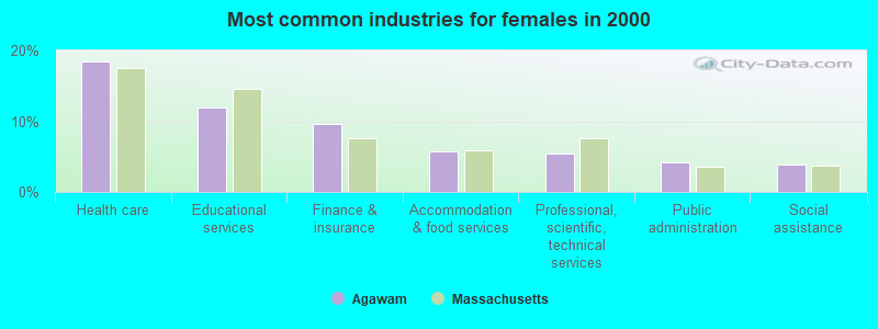
- Health care (18.5%)
- Educational services (11.9%)
- Finance & insurance (9.7%)
- Accommodation & food services (5.8%)
- Professional, scientific, technical services (5.4%)
- Public administration (4.1%)
- Social assistance (3.8%)
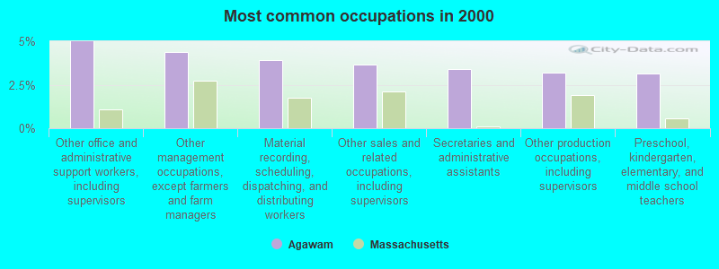
- Other office and administrative support workers, including supervisors (5.0%)
- Other management occupations, except farmers and farm managers (4.4%)
- Material recording, scheduling, dispatching, and distributing workers (3.9%)
- Other sales and related occupations, including supervisors (3.7%)
- Secretaries and administrative assistants (3.4%)
- Other production occupations, including supervisors (3.2%)
- Preschool, kindergarten, elementary, and middle school teachers (3.1%)
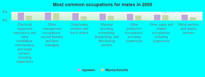
- Electrical equipment mechanics and other installation, maintenance, and repair workers, including supervisors (5.7%)
- Other management occupations, except farmers and farm managers (5.7%)
- Driver/sales workers and truck drivers (5.4%)
- Material recording, scheduling, dispatching, and distributing workers (4.9%)
- Other production occupations, including supervisors (4.7%)
- Other sales and related occupations, including supervisors (4.2%)
- Metal workers and plastic workers (4.2%)
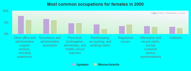
- Other office and administrative support workers, including supervisors (7.9%)
- Secretaries and administrative assistants (6.6%)
- Preschool, kindergarten, elementary, and middle school teachers (4.7%)
- Bookkeeping, accounting, and auditing clerks (4.3%)
- Registered nurses (3.5%)
- Information and record clerks, except customer service representatives (3.5%)
- Cashiers (3.1%)
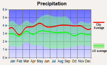
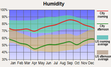
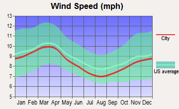
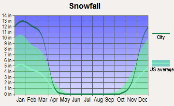
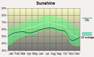
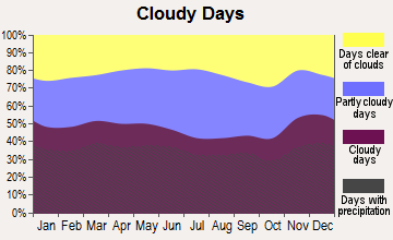
Average climate in Agawam, Massachusetts
Based on data reported by over 4,000 weather stations

|
|

(lower is better)
Air Quality Index (AQI) level in 2022 was 78.6. This is about average.
| City: | 78.6 |
| U.S.: | 72.6 |
Carbon Monoxide (CO) [ppm] level in 2022 was 0.312. This is worse than average. Closest monitor was 2.8 miles away from the city center.
| City: | 0.312 |
| U.S.: | 0.251 |
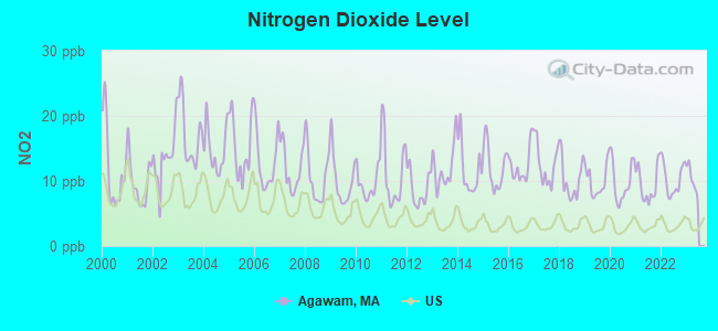
Nitrogen Dioxide (NO2) [ppb] level in 2022 was 10.3. This is significantly worse than average. Closest monitor was 1.9 miles away from the city center.
| City: | 10.3 |
| U.S.: | 5.1 |
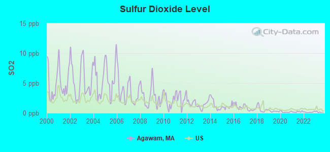
Sulfur Dioxide (SO2) [ppb] level in 2022 was 0.144. This is significantly better than average. Closest monitor was 2.8 miles away from the city center.
| City: | 0.144 |
| U.S.: | 1.515 |
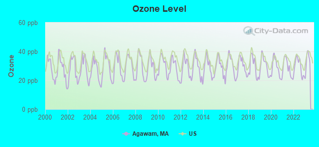
Ozone [ppb] level in 2022 was 29.4. This is about average. Closest monitor was 1.9 miles away from the city center.
| City: | 29.4 |
| U.S.: | 33.3 |
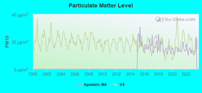
Particulate Matter (PM10) [µg/m3] level in 2022 was 13.8. This is better than average. Closest monitor was 3.4 miles away from the city center.
| City: | 13.8 |
| U.S.: | 19.2 |
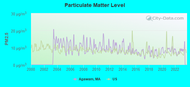
Particulate Matter (PM2.5) [µg/m3] level in 2022 was 7.34. This is about average. Closest monitor was 3.4 miles away from the city center.
| City: | 7.34 |
| U.S.: | 8.11 |
Tornado activity:
Agawam-area historical tornado activity is above Massachusetts state average. It is 9% smaller than the overall U.S. average.
On 10/3/1979, a category F4 (max. wind speeds 207-260 mph) tornado 3.2 miles away from the Agawam city center killed 3 people and injured 500 people and caused between $50,000,000 and $500,000,000 in damages.
On 5/29/1995, a category F4 tornado 27.8 miles away from the city center killed 3 people and injured 24 people and caused between $5,000,000 and $50,000,000 in damages.
Earthquake activity:
Agawam-area historical earthquake activity is significantly above Massachusetts state average. It is 70% smaller than the overall U.S. average.On 10/7/1983 at 10:18:46, a magnitude 5.3 (5.1 MB, 5.3 LG, 5.1 ML, Class: Moderate, Intensity: VI - VII) earthquake occurred 155.9 miles away from the city center
On 4/20/2002 at 10:50:47, a magnitude 5.3 (5.3 ML, Depth: 3.0 mi) earthquake occurred 176.9 miles away from Agawam center
On 4/20/2002 at 10:50:47, a magnitude 5.2 (5.2 MB, 4.2 MS, 5.2 MW, 5.0 MW) earthquake occurred 175.6 miles away from the city center
On 1/19/1982 at 00:14:42, a magnitude 4.7 (4.5 MB, 4.7 MD, 4.5 LG, Class: Light, Intensity: IV - V) earthquake occurred 112.1 miles away from the city center
On 10/16/2012 at 23:12:25, a magnitude 4.7 (4.7 ML, Depth: 10.0 mi) earthquake occurred 145.9 miles away from Agawam center
On 8/23/2011 at 17:51:04, a magnitude 5.8 (5.8 MW, Depth: 3.7 mi) earthquake occurred 401.8 miles away from the city center
Magnitude types: regional Lg-wave magnitude (LG), body-wave magnitude (MB), duration magnitude (MD), local magnitude (ML), surface-wave magnitude (MS), moment magnitude (MW)
Natural disasters:
The number of natural disasters in Hampden County (22) is greater than the US average (15).Major Disasters (Presidential) Declared: 12
Emergencies Declared: 9
Causes of natural disasters: Storms: 6, Floods: 5, Hurricanes: 5, Snowstorms: 4, Winter Storms: 4, Blizzards: 2, Snows: 2, Snowfall: 1, Tornado: 1, Tropical Storm: 1, Wind: 1, Other: 1 (Note: some incidents may be assigned to more than one category).

Hospitals and medical centers in Agawam:
- HOSPICE SERVICES OF WESTERN MASSACHUSETTS LLC (BUXTON OFFICE PARK, 540 MEADOW ST, SUITE 104-105)
- HERITAGE HALL SOUTH (65 COOPER STREET)
- KINDRED TRANSITIONAL CARE AND REHAB-COUNTRY ESTATES (1200 SUFFIELD STREET)
- HERITAGE DIALYSIS CENTER, LLC (67 COOPER STREET)
- AMEDISYS HOME HEALTH OF AGAWAM (67 HUNT STREET, SUITE 102)
- GENESIS ELDERCARE HOME CARE SERVICES (540 MEADOW STREET EXTENSION 2ND FLOOR)
Heliports located in Agawam:
Amtrak stations near Agawam:
- 4 miles: SPRINGFIELD (66 LYMAN ST.) . Services: ticket office, partially wheelchair accessible, enclosed waiting area, public restrooms, public payphones, full-service food facilities, snack bar, vending machines, ATM, paid short-term parking, paid long-term parking, call for car rental service, taxi stand, intercity bus service, public transit connection.
- 11 miles: WINDSOR LOCKS (S. MAIN ST. (RTE. 159)) . Services: public payphones, free short-term parking, free long-term parking, call for car rental service, call for taxi service, public transit connection.
- 16 miles: WINDSOR (41 CENTRAL ST.) . Services: enclosed waiting area, public restrooms, public payphones, free short-term parking, call for car rental service, call for taxi service, public transit connection.
Colleges/universities with over 2000 students nearest to Agawam:
- Bay Path College (about 4 miles; Longmeadow, MA; Full-time enrollment: 2,085)
- Springfield Technical Community College (about 5 miles; Springfield, MA; FT enrollment: 4,750)
- Springfield College (about 6 miles; Springfield, MA; FT enrollment: 3,144)
- American International College (about 6 miles; Springfield, MA; FT enrollment: 2,733)
- Western New England University (about 8 miles; Springfield, MA; FT enrollment: 3,477)
- Holyoke Community College (about 9 miles; Holyoke, MA; FT enrollment: 4,911)
- Westfield State University (about 9 miles; Westfield, MA; FT enrollment: 5,548)
Public high school in Agawam:
- AGAWAM HIGH (Students: 1,303, Location: 760 COOPER STREET, Grades: 9-12)
Public elementary/middle schools in Agawam:
- ROBINSON PARK (Students: 409, Location: 65 BEGLEY STREET, Grades: KG-4)
- BENJAMIN J PHELPS (Students: 390, Location: 689 MAIN STREET, Grades: KG-4)
- JAMES CLARK SCHOOL (Students: 376, Location: 65 OXFORD STREET, Grades: KG-4)
- ROBERTA G. DOERING SCHOOL (Location: 68 MAIN STREET, Grades: 5-8)
Points of interest:
Notable locations in Agawam: Crestview Country Club (A), Oak Ridge Golf Club (B), Saint Anne Country Club (C), Southgate Shopping Plaza (D), Agawam Regional Industrial Park (E), Agawam Town Hall (F), Agawam Fire Department Station 2 (G), Agawam Fire Department Station 1 Headquarters (H), Clifford M Granger School Library (I). Display/hide their locations on the map
Shopping Centers: Agawam Shopping Center (1), Bridge Shopping Center (2). Display/hide their locations on the map
Churches in Agawam include: Valley Community Church (A), Saint Davids Episcopal Church (B), Sacred Heart Parish Center (C), Greater Springfield Korean Church (D), Grace Baptist Church (E), Feeding Hills Congregational Church (F), Faith Bible Church (G), Crossroads Christian Church (H), Calvary Assembly of God Church (I). Display/hide their locations on the map
Cemetery: North Cemetery (1). Display/hide its location on the map
Lakes and reservoirs: Taylor Pond (A), Leonard Pond (B), Harts Pond (C), Silver Lake (D), Westfield River Reservoir (E), Silver Lake Reservoir (F). Display/hide their locations on the map
Streams, rivers, and creeks: Miller Brook (A), Paucatuck Brook (B), White Brook (C), Westfield River (D), Tarkill Brook (E), Threemile Brook (F), Worthington Brook (G). Display/hide their locations on the map
Parks in Agawam include: Meadowbrook Park (1), Perry Lane Park (2), Shea Field (3), Wade Park (4), Borgati Park (5), Smith Field (6), Riverside Park (7), Cohen Park (8). Display/hide their locations on the map
Hotel: Agawam Motor Lodge (23 Suffield Street) (1). Display/hide its approximate location on the map
Birthplace of: Frankie Arion - Professional wrestler, Anne Sullivan - Teacher and companion of Helen Keller, Doug Janik - NHL player (Buffalo Sabres, born: Mar 26, 1980), Norman C. Stiles - Inventor, Edwin Leonard - Civil War Medal of Honor recipient, Frank Rosso - Baseball player.
Drinking water stations with addresses in Agawam and their reported violations in the past:
AGAWAM WATER DEPARTMENT (Population served: 28,438, Purch surface water):Past health violations:Past monitoring violations:
- MCL, Average - Between JAN-2014 and MAR-2014, Contaminant: Total Haloacetic Acids (HAA5). Follow-up actions: St AO (w/o penalty) issued (2 times from SEP-18-2013 to MAR-21-2014)
- MCL, Average - Between JAN-2013 and MAR-2013, Contaminant: Total Haloacetic Acids (HAA5). Follow-up actions: St AO (w/o penalty) issued (SEP-18-2013)
- Monitoring and Reporting (DBP) - Between JUL-10-2009 and SEP-30-2009, Contaminant: Total Haloacetic Acids (HAA5). Follow-up actions: St AO (w/o penalty) issued (NOV-13-2009)
- Follow-up Or Routine LCR Tap M/R - In OCT-01-2005, Contaminant: Lead and Copper Rule. Follow-up actions: St AO (w/o penalty) issued (JAN-03-2006), St Compliance achieved (JAN-03-2006)
- Monitoring and Reporting (DBP) - Between JAN-2005 and MAR-2005, Contaminant: TTHM. Follow-up actions: St AO (w/o penalty) issued (APR-25-2005)
| This city: | 2.4 people |
| Massachusetts: | 2.5 people |
| This city: | 66.3% |
| Whole state: | 65.0% |
| This city: | 5.0% |
| Whole state: | 5.4% |
Likely homosexual households (counted as self-reported same-sex unmarried-partner households)
- Lesbian couples: 0.3% of all households
- Gay men: 0.2% of all households
| This city: | 5.6% |
| Whole state: | 9.3% |
| This city: | 2.3% |
| Whole state: | 4.4% |
Banks with branches in Agawam (2011 data):
- Hampden Bank: Agawam Branch at 820 Suffield Strret, branch established on 2001/06/16. Info updated 2012/04/04: Bank assets: $563.1 mil, Deposits: $428.3 mil, headquarters in Springfield, MA, positive income, Commercial Lending Specialization, 10 total offices, Holding Company: Hampden Bancorp, Inc.
- RBS Citizens, National Association: Agawam Stop & Shop Branch at 1282 Springfield Street, branch established on 2002/07/03. Info updated 2007/09/19: Bank assets: $106,940.6 mil, Deposits: $75,690.2 mil, headquarters in Providence, RI, positive income, 1135 total offices, Holding Company: Uk Financial Investments Limited
- United Bank: Agawam Branch at 806 Suffield Street, branch established on 2008/04/21. Info updated 2012/01/20: Bank assets: $1,617.9 mil, Deposits: $1,235.2 mil, headquarters in West Springfield, MA, positive income, Commercial Lending Specialization, 25 total offices
- TD Bank, National Association: Agawam Branch at 40 Springfield Street, branch established on 1956/10/26. Info updated 2010/10/04: Bank assets: $188,912.6 mil, Deposits: $153,149.8 mil, headquarters in Wilmington, DE, positive income, 1314 total offices, Holding Company: Toronto-Dominion Bank, The
- Westfield Bank: Agawam Branch at 655 Main Street, branch established on 1968/06/26. Info updated 2011/07/21: Bank assets: $1,259.3 mil, Deposits: $733.6 mil, headquarters in Westfield, MA, positive income, Commercial Lending Specialization, 12 total offices
- Easthampton Savings Bank: Agawam Branch at 770 Main Street, branch established on 2011/04/11. Info updated 2008/10/14: Bank assets: $939.2 mil, Deposits: $757.1 mil, headquarters in Easthampton, MA, positive income, Mortgage Lending Specialization, 9 total offices, Holding Company: Esb Bancorp Mhc
For population 15 years and over in Agawam:
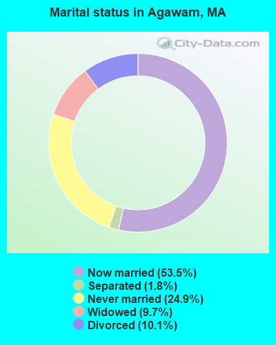
- Never married: 24.9%
- Now married: 53.5%
- Separated: 1.8%
- Widowed: 9.7%
- Divorced: 10.1%
For population 25 years and over in Agawam:
- High school or higher: 87.5%
- Bachelor's degree or higher: 21.4%
- Graduate or professional degree: 6.4%
- Unemployed: 4.1%
- Mean travel time to work (commute): 20.5 minutes
| Here: | 10.2 |
| Massachusetts average: | 13.1 |
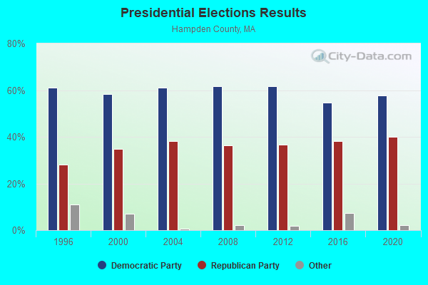
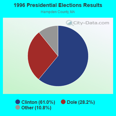
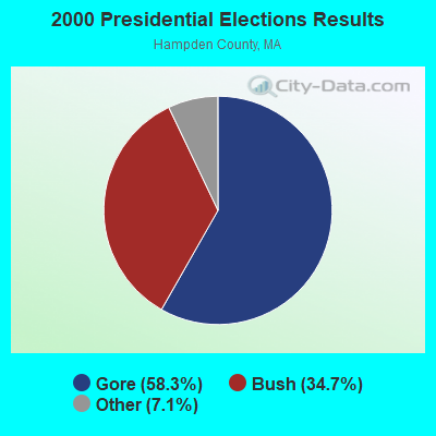
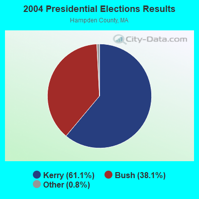
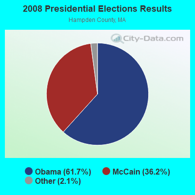
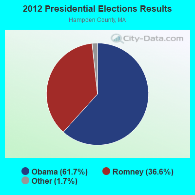
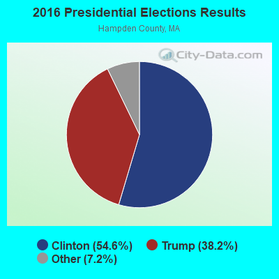
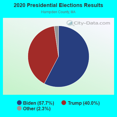
Graphs represent county-level data. Detailed 2008 Election Results
Religion statistics for Agawam, MA (based on Hampden County data)
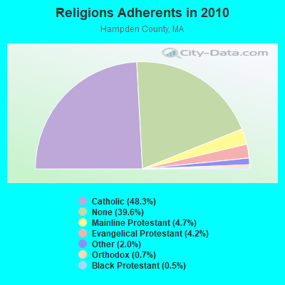
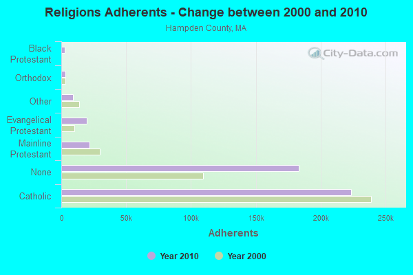
| Religion | Adherents | Congregations |
|---|---|---|
| Catholic | 223,685 | 65 |
| Mainline Protestant | 21,962 | 88 |
| Evangelical Protestant | 19,438 | 114 |
| Other | 9,140 | 31 |
| Orthodox | 3,406 | 10 |
| Black Protestant | 2,491 | 16 |
| None | 183,368 | - |
Food Environment Statistics:
| Hampden County: | 1.95 / 10,000 pop. |
| Massachusetts: | 1.98 / 10,000 pop. |
| This county: | 0.04 / 10,000 pop. |
| State: | 0.05 / 10,000 pop. |
| Hampden County: | 1.87 / 10,000 pop. |
| Massachusetts: | 2.22 / 10,000 pop. |
| Hampden County: | 2.43 / 10,000 pop. |
| State: | 1.77 / 10,000 pop. |
| Here: | 7.27 / 10,000 pop. |
| State: | 8.76 / 10,000 pop. |
| This county: | 9.2% |
| Massachusetts: | 8.1% |
| Hampden County: | 25.9% |
| Massachusetts: | 22.5% |
| This county: | 16.2% |
| State: | 16.5% |
| Local government employment and payroll (March 2007) | |||||
| Function | Full-time employees | Monthly full-time payroll | Average yearly full-time wage | Part-time employees | Monthly part-time payroll |
|---|---|---|---|---|---|
| Elementary and Secondary - Instruction | 521 | $2,028,841 | $46,730 | 21 | $13,659 |
| Police Protection - Officers | 72 | $290,806 | $48,468 | 0 | $0 |
| Financial Administration | 54 | $132,327 | $29,406 | 0 | $0 |
| Elementary and Secondary - Other Total | 43 | $149,624 | $41,756 | 77 | $63,428 |
| Sewerage | 36 | $87,690 | $29,230 | 0 | $0 |
| Other Government Administration | 36 | $126,675 | $42,225 | 0 | $0 |
| Streets and Highways | 18 | $77,251 | $51,501 | 36 | $38,103 |
| Judicial and Legal | 0 | $0 | 0 | $0 | |
| Police - Other | 0 | $0 | 0 | $0 | |
| Firefighters | 0 | $0 | 0 | $0 | |
| Fire - Other | 0 | $0 | 0 | $0 | |
| Correction | 0 | $0 | 0 | $0 | |
| Airports | 0 | $0 | 0 | $0 | |
| Water Transport and Terminals | 0 | $0 | 0 | $0 | |
| Welfare | 0 | $0 | 0 | $0 | |
| Health | 0 | $0 | 0 | $0 | |
| Hospitals | 0 | $0 | 0 | $0 | |
| Solid Waste Management | 0 | $0 | 0 | $0 | |
| Parks and Recreation | 0 | $0 | 0 | $0 | |
| Housing and Community Development (Local) | 0 | $0 | 0 | $0 | |
| Natural Resources | 0 | $0 | 0 | $0 | |
| Water Supply | 0 | $0 | 0 | $0 | |
| Electric Power | 0 | $0 | 0 | $0 | |
| Gas Supply | 0 | $0 | 0 | $0 | |
| Transit | 0 | $0 | 0 | $0 | |
| Local Libraries | 0 | $0 | 0 | $0 | |
| Other and Unallocable | 0 | $0 | 0 | $0 | |
| Totals for Government | 780 | $2,893,214 | $44,511 | 134 | $115,190 |
Agawam government finances - Expenditure in 2002 (per resident):
- Construction - Regular Highways: $20,000 ($0.70)
Central Staff Services: $14,000 ($0.49)
Elementary and Secondary Education: $0 ($0.00)
- Current Operations - Elementary and Secondary Education: $33,450,000 ($1168.93)
General - Other: $8,614,000 ($301.02)
Regular Highways: $3,525,000 ($123.18)
Police Protection: $3,169,000 ($110.74)
General Public Buildings: $2,666,000 ($93.16)
Fire Protection: $2,650,000 ($92.61)
Sewerage: $1,629,000 ($56.93)
Solid Waste Management: $1,398,000 ($48.85)
Water Utilities: $1,294,000 ($45.22)
Libraries: $765,000 ($26.73)
Parks and Recreation: $759,000 ($26.52)
Financial Administration: $668,000 ($23.34)
Central Staff Services: $540,000 ($18.87)
Health Services - Other: $376,000 ($13.14)
Protective Inspection and Regulation - Other: $212,000 ($7.41)
Judicial and Legal Services: $126,000 ($4.40)
Welfare - Other: $86,000 ($3.01)
- General - Interest on Debt: $1,567,000 ($54.76)
- Intergovernmental to Local - Other - Elementary and Secondary Education: $2,449,000 ($85.58)
Other - Health: $6,000 ($0.21)
- Intergovernmental to State - Transit Utilities: $144,000 ($5.03)
General: $19,000 ($0.66)
- Other Capital Outlay - General Public Building: $3,961,000 ($138.42)
Elementary and Secondary Education: $327,000 ($11.43)
Regular Highways: $125,000 ($4.37)
Police Protection: $90,000 ($3.15)
Sewerage: $22,000 ($0.77)
- Total Salaries and Wages: $33,697,000 ($1177.56)
Agawam government finances - Revenue in 2002 (per resident):
- Charges - Other: $2,546,000 ($88.97)
Sewerage: $2,426,000 ($84.78)
Parks and Recreation: $1,007,000 ($35.19)
Elementary and Secondary Education School Lunch: $530,000 ($18.52)
Solid Waste Management: $517,000 ($18.07)
Elementary and Secondary Education School Tuition: $146,000 ($5.10)
Elementary and Secondary Education - Other: $84,000 ($2.94)
- Miscellaneous - Interest Earnings: $715,000 ($24.99)
General Revenue - Other: $252,000 ($8.81)
- Revenue - Water Utilities: $2,149,000 ($75.10)
- State Intergovernmental - Education: $15,547,000 ($543.30)
General Support: $3,770,000 ($131.74)
Other: $1,585,000 ($55.39)
Highways: $600,000 ($20.97)
Public Welfare: $45,000 ($1.57)
- Tax - Property: $34,098,000 ($1191.57)
Other: $133,000 ($4.65)
Other Selective Sales: $57,000 ($1.99)
Agawam government finances - Debt in 2002 (per resident):
- Long Term Debt - Beginning Outstanding, Education - Other: $18,772,000 ($656.00)
Outstanding - Full Faith and Credit - Elementary and Secondary Education: $18,371,000 ($641.98)
Outstanding - Full Faith and Credit - Other - Other: $11,624,000 ($406.21)
Beginning Outstanding - Other: $6,688,000 ($233.72)
Issue, Unspecified - Other - Other: $5,490,000 ($191.85)
Retired Unspecified - Elementary and Secondary Education: $1,151,000 ($40.22)
Issue, Unspecified - Elementary and Secondary Education: $750,000 ($26.21)
Retired Unspecified - Other - Other: $554,000 ($19.36)
- Short Term Debt Outstanding - Beginning: $5,350,000 ($186.96)
Agawam government finances - Cash and Securities in 2002 (per resident):
- Bond Fund - Cash and Deposits: $2,393,000 ($83.62)
- Other Funds - Cash and Deposits: $22,541,000 ($787.71)
3.64% of this county's 2021 resident taxpayers lived in other counties in 2020 ($58,474 average adjusted gross income)
| Here: | 3.64% |
| Massachusetts average: | 6.35% |
0.02% of residents moved from foreign countries ($105 average AGI)
Hampden County: 0.02% Massachusetts average: 0.01%
Top counties from which taxpayers relocated into this county between 2020 and 2021:
| from Hampshire County, MA | |
| from Hartford County, CT | |
| from Worcester County, MA |
4.26% of this county's 2020 resident taxpayers moved to other counties in 2021 ($66,146 average adjusted gross income)
| Here: | 4.26% |
| Massachusetts average: | 7.18% |
0.03% of residents moved to foreign countries ($223 average AGI)
Hampden County: 0.03% Massachusetts average: 0.02%
Top counties to which taxpayers relocated from this county between 2020 and 2021:
| to Hampshire County, MA | |
| to Hartford County, CT | |
| to Worcester County, MA |
| Businesses in Agawam, MA | ||||
| Name | Count | Name | Count | |
|---|---|---|---|---|
| Ace Hardware | 1 | MasterBrand Cabinets | 2 | |
| Ben & Jerry's | 2 | McDonald's | 1 | |
| CVS | 2 | Panda Express | 1 | |
| Cold Stone Creamery | 2 | Penske | 1 | |
| Domino's Pizza | 1 | Rite Aid | 1 | |
| Dunkin Donuts | 2 | Stop & Shop | 1 | |
| FedEx | 3 | Subway | 2 | |
| Ford | 1 | U-Haul | 1 | |
| Johnny Rockets | 1 | UPS | 3 | |
| Jones New York | 1 | Walgreens | 1 | |
Strongest AM radio stations in Agawam:
- WSPR (1270 AM; 5 kW; SPRINGFIELD, MA; Owner: ANTONIO F. AND HELENA R. GOIS, TENANTS BY THE ENTIRETY)
- WNNZ (640 AM; 50 kW; WESTFIELD, MA; Owner: CLEAR CHANNEL BROADCASTING LICENSES, INC.)
- WACE (730 AM; 5 kW; CHICOPEE, MA; Owner: CARTER BROADCASTING CORP.)
- WACM (1490 AM; 1 kW; WEST SPRINGFIELD, MA; Owner: ANTONIO F. GOIS)
- WHYN (560 AM; 5 kW; SPRINGFIELD, MA; Owner: CLEAR CHANNEL BROADCASTING LICENSES, INC.)
- WTIC (1080 AM; 50 kW; HARTFORD, CT; Owner: INFINITY RADIO OPERATIONS INC.)
- WMAS (1450 AM; 1 kW; SPRINGFIELD, MA; Owner: LAPPIN COMMUNICATIONS, INC.)
- WHNP (1600 AM; 2 kW; EAST LONGMEADOW, MA; Owner: SAGA COMMUNICATIONS OF NEW ENGLAND, LLC)
- WCRN (830 AM; 50 kW; WORCESTER, MA; Owner: CARTER BROADCASTING CORPORATION)
- WVNE (760 AM; daytime; 25 kW; LEICESTER, MA; Owner: BLOUNT MASSCOM, INC.)
- WALE (990 AM; 50 kW; GREENVILLE, RI; Owner: NORTH AMERICAN BROADCASTING CO., INC.)
- WDZK (1550 AM; 5 kW; BLOOMFIELD, CT; Owner: ABC, INC.)
- WDRC (1360 AM; 5 kW; HARTFORD, CT; Owner: BUCKLEY BROADCASTING CORPORATION)
Strongest FM radio stations in Agawam:
- WAQY (102.1 FM; SPRINGFIELD, MA; Owner: SAGA COMMUNICATIONS OF NEW ENGLAND, LLC)
- WPKX (97.9 FM; ENFIELD, CT; Owner: CAPSTAR TX LIMITED PARTNERSHIP)
- WMAS-FM (94.7 FM; SPRINGFIELD, MA; Owner: LAPPIN COMMUNICATIONS, INC.)
- WHYN-FM (93.1 FM; SPRINGFIELD, MA; Owner: CLEAR CHANNEL BROADCASTING LICENSES, INC.)
- WRNX (100.9 FM; AMHERST, MA; Owner: WESTERN MASSACHUSETTS RADIO COMPANY)
- WRCH (100.5 FM; NEW BRITAIN, CT; Owner: INFINITY RADIO OPERATIONS INC.)
- WFCR (88.5 FM; AMHERST, MA; Owner: UNIVERSITY OF MASSACHUSETTS)
- WCCH (103.5 FM; HOLYOKE, MA; Owner: HOLYOKE COMMUNITY COLLEGE)
- WTCC (90.7 FM; SPRINGFIELD, MA; Owner: SPRINGFIELD TECH. COMM. COLLEGE)
- WTIC-FM (96.5 FM; HARTFORD, CT; Owner: INFINITY RADIO OPERATIONS INC.)
- WCCC-FM (106.9 FM; HARTFORD, CT; Owner: MARLIN BROADCASTING, LLC)
- WWUH (91.3 FM; WEST HARTFORD, CT; Owner: UNIVERSITY OF HARTFORD)
- WAMC-FM (90.3 FM; ALBANY, NY; Owner: WAMC)
- WAMH (89.3 FM; AMHERST, MA; Owner: TRUSTEES OF AMHERST COLLEGE)
- W246AM (97.1 FM; AMHERST, MA; Owner: GREAT NORTHERN RADIO, LLC)
- WAAF (107.3 FM; WORCESTER, MA; Owner: ENTERCOM BOSTON LICENSE, LLC)
- WWYZ (92.5 FM; WATERBURY, CT; Owner: CAPSTAR TX LIMITED PARTNERSHIP)
- WKSS (95.7 FM; HARTFORD-MERIDEN, CT; Owner: CAPSTAR TX LIMITED PARTNERSHIP)
- WZMX (93.7 FM; HARTFORD, CT; Owner: INFINITY RADIO OPERATIONS INC.)
- WHCN (105.9 FM; HARTFORD, CT; Owner: CAPSTAR TX LIMITED PARTNERSHIP)
TV broadcast stations around Agawam:
- WWLP (Channel 22; SPRINGFIELD, MA; Owner: WWLP BROADCASTING, LLC)
- WDMR-LP (Channel 65; SPRINGFIELD, MA; Owner: ZGS HARTFORD, INC.)
- W67DF (Channel 67; SPRINGFIELD, MA; Owner: TRINITY BROADCASTING NETWORK)
- W12CL (Channel 12; GRANBY, CT; Owner: SALVATORE MINNITI)
- WTIC-TV (Channel 61; HARTFORD, CT; Owner: TRIBUNE TELEVISION COMPANY)
- W11BJ (Channel 11; HARTFORD, CT; Owner: COMMUNICATIONS SITE MANAGEMENT LLC)
- WYDN (Channel 48; WORCESTER, MA; Owner: EDUCATIONAL PUBLIC TV CORPORATION)
- WUVN (Channel 18; HARTFORD, CT; Owner: ENTRAVISION HOLDINGS, LLC)
- WTXX (Channel 20; WATERBURY, CT; Owner: WTXX INC.)
- WVIT (Channel 30; NEW BRITAIN, CT; Owner: OUTLET BROADCASTING, INC)
- WEDH (Channel 24; HARTFORD, CT; Owner: CONNECTICUT PUBLIC BROADCASTING, INC.)
- WFSB (Channel 3; HARTFORD, CT; Owner: MEREDITH CORPORATION)
- WHCT-LP (Channel 38; HARTFORD, CT; Owner: VENTURE TECHNOLOGIES GROUP, LLC)
- WUNI (Channel 27; WORCESTER, MA; Owner: ENTRAVISION HOLDINGS, LLC)
- WGBY-TV (Channel 57; SPRINGFIELD, MA; Owner: WGBH EDUCATIONAL FOUNDATION)
- WGGB-TV (Channel 40; SPRINGFIELD, MA; Owner: WGGB LICENSEE, LLC)
- WHTX-LP (Channel 10; HARTFORD, CT; Owner: ENTRAVISION HOLDINGS, LLC)
- WRDM-LP (Channel 13; HARTFORD, CT; Owner: ZGS HARTFORD, INC.)
- WMLD-LP (Channel 6; HARTFORD, CT; Owner: HARVARD BROADCASTING, INC.)
- National Bridge Inventory (NBI) Statistics
- 16Number of bridges
- 400ft / 122mTotal length
- $131,054,000Total costs
- 598,679Total average daily traffic
- 80,732Total average daily truck traffic
- 607,179Total future (year 2031) average daily traffic
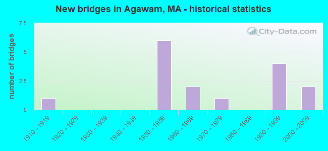
- New bridges - historical statistics
- 11910-1919
- 61950-1959
- 21960-1969
- 11970-1979
- 41990-1999
- 22000-2009
FCC Registered Cell Phone Towers:
1 (See the full list of FCC Registered Cell Phone Towers in Agawam)FCC Registered Antenna Towers:
51 (See the full list of FCC Registered Antenna Towers)FCC Registered Commercial Land Mobile Towers:
1 (See the full list of FCC Registered Commercial Land Mobile Towers in Agawam, MA)FCC Registered Broadcast Land Mobile Towers:
15 (See the full list of FCC Registered Broadcast Land Mobile Towers)FCC Registered Microwave Towers:
12 (See the full list of FCC Registered Microwave Towers in this town)FCC Registered Paging Towers:
3 (See the full list of FCC Registered Paging Towers)FCC Registered Amateur Radio Licenses:
55 (See the full list of FCC Registered Amateur Radio Licenses in Agawam)FAA Registered Aircraft:
5- Aircraft: AERO SP Z O O AT-4 LSA (Category: Land, Seats: 2, Weight: Up to 12,499 Pounds), Engine: ROTAX 912ULS SERIES (100 HP) (4 Cycle)
N-Number: 1890R, N1890R, N-1890R, Serial Number: AT4-011, Year manufactured: 2007, Airworthiness Date: 05/09/2008, Certificate Issue Date: 11/08/2016
Registrant (Individual): Kurt J Dahdah, 26 Cottonwood Ln, Agawam, MA 01001 - Aircraft: PIPER PA-32-300 (Category: Land, Seats: 6, Weight: Up to 12,499 Pounds, Speed: 126 mph), Engine: LYCOMING IO-540 SER (300 HP) (Reciprocating)
N-Number: 2200S, N2200S, N-2200S, Serial Number: 32-7940055, Year manufactured: 1979, Airworthiness Date: 02/12/1979, Certificate Issue Date: 02/07/2020
Registrant (Individual): Mark E Benoit, 21 Alexander Dr, Agawam, MA 01001 - Aircraft: PIPER PA-28-140 (Category: Land, Seats: 4, Weight: Up to 12,499 Pounds, Speed: 107 mph), Engine: LYCOMING 0-320 SERIES (180 HP) (Reciprocating)
N-Number: 6334R, N6334R, N-6334R, Serial Number: 28-21503, Year manufactured: 1966, Airworthiness Date: 03/14/1966, Certificate Issue Date: 06/16/1995
Registrant (Individual): William J Pollock, 341 Meadow St, Agawam, MA 01001 - Aircraft: BEECH A36 (Category: Land, Seats: 6, Weight: Up to 12,499 Pounds, Speed: 138 mph), Engine: CONT MOTOR IO 520 SERIES (285 HP) (Reciprocating)
N-Number: 66JL, N66JL, N-66JL, Serial Number: E-711, Year manufactured: 1975, Airworthiness Date: 06/03/1977, Certificate Issue Date: 08/31/2017
Registrant (Partnership): Joanne Lucia, Po Box 777, Agawam, MA 01001, Other Owners: Steven R Lucia - Aircraft: TAYLORCRAFT BF (Category: Land, Seats: 2, Weight: Up to 12,499 Pounds, Speed: 78 mph), Engine: CONT MOTOR A&C65 SERIES (65 HP) (Reciprocating)
N-Number: 44417, N44417, N-44417, Serial Number: 10217, Year manufactured: 1946
Registrant (Individual): Raymond L Buxton, 707 Silver St Box 202, Agawam, MA 01001
Deregistered: Cancel Date: 07/19/2018
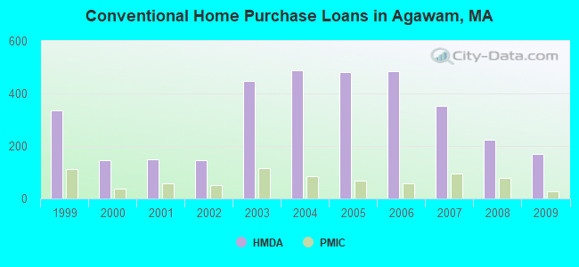
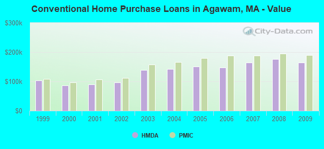
| Home Mortgage Disclosure Act Aggregated Statistics For Year 2009 (Based on 5 full tracts) | ||||||||||||
| A) FHA, FSA/RHS & VA Home Purchase Loans | B) Conventional Home Purchase Loans | C) Refinancings | D) Home Improvement Loans | E) Loans on Dwellings For 5+ Families | F) Non-occupant Loans on < 5 Family Dwellings (A B C & D) | |||||||
|---|---|---|---|---|---|---|---|---|---|---|---|---|
| Number | Average Value | Number | Average Value | Number | Average Value | Number | Average Value | Number | Average Value | Number | Average Value | |
| LOANS ORIGINATED | 92 | $195,467 | 169 | $163,775 | 725 | $164,873 | 75 | $109,000 | 2 | $2,382,500 | 22 | $119,091 |
| APPLICATIONS APPROVED, NOT ACCEPTED | 5 | $189,000 | 9 | $176,444 | 44 | $163,182 | 15 | $64,533 | 0 | $0 | 2 | $108,500 |
| APPLICATIONS DENIED | 6 | $171,833 | 26 | $203,269 | 201 | $178,776 | 40 | $70,175 | 0 | $0 | 7 | $93,714 |
| APPLICATIONS WITHDRAWN | 10 | $186,800 | 24 | $199,292 | 127 | $192,031 | 3 | $101,333 | 0 | $0 | 2 | $115,500 |
| FILES CLOSED FOR INCOMPLETENESS | 2 | $170,000 | 9 | $224,333 | 62 | $178,710 | 2 | $93,500 | 0 | $0 | 0 | $0 |
Detailed HMDA statistics for the following Tracts: 8132.03 , 8132.04, 8132.05, 8132.06, 8132.07
| Private Mortgage Insurance Companies Aggregated Statistics For Year 2009 (Based on 5 full tracts) | ||||
| A) Conventional Home Purchase Loans | B) Refinancings | |||
|---|---|---|---|---|
| Number | Average Value | Number | Average Value | |
| LOANS ORIGINATED | 26 | $189,500 | 24 | $194,958 |
| APPLICATIONS APPROVED, NOT ACCEPTED | 4 | $158,250 | 7 | $215,429 |
| APPLICATIONS DENIED | 7 | $165,857 | 11 | $187,364 |
| APPLICATIONS WITHDRAWN | 1 | $145,000 | 1 | $183,000 |
| FILES CLOSED FOR INCOMPLETENESS | 0 | $0 | 1 | $136,000 |
Detailed PMIC statistics for the following Tracts: 8132.03 , 8132.04, 8132.05, 8132.06, 8132.07
2002 - 2018 National Fire Incident Reporting System (NFIRS) incidents
- Fire incident types reported to NFIRS in Agawam, MA
- 64246.5%Structure Fires
- 46433.6%Outside Fires
- 19314.0%Mobile Property/Vehicle Fires
- 815.9%Other
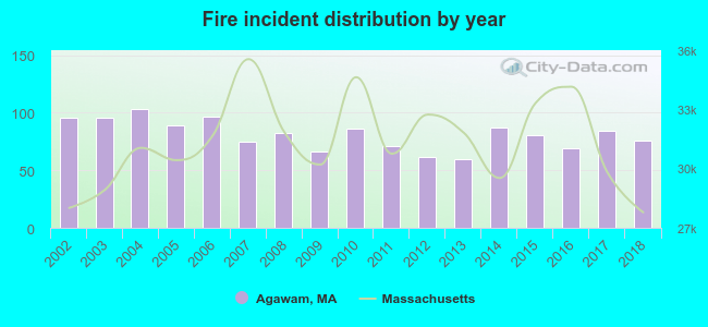 Based on the data from the years 2002 - 2018 the average number of fire incidents per year is 81. The highest number of fires - 103 took place in 2004, and the least - 60 in 2013. The data has a dropping trend.
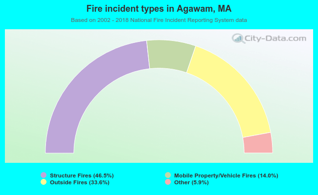 When looking into fire subcategories, the most reports belonged to: Structure Fires (46.5%), and Outside Fires (33.6%).
- 58.0%Utility gas
- 28.2%Fuel oil, kerosene, etc.
- 9.9%Electricity
- 1.7%Bottled, tank, or LP gas
- 1.5%Wood
- 0.4%Other fuel
- 0.2%Coal or coke
- 42.1%Utility gas
- 40.2%Electricity
- 15.0%Fuel oil, kerosene, etc.
- 1.3%Bottled, tank, or LP gas
- 0.8%No fuel used
- 0.6%Wood
Agawam compared to Massachusetts state average:
- Median house value below state average.
- Unemployed percentage significantly below state average.
- Black race population percentage significantly below state average.
- Hispanic race population percentage significantly below state average.
- Foreign-born population percentage significantly below state average.
- Renting percentage significantly below state average.
- Length of stay since moving in significantly above state average.
- Number of rooms per house significantly below state average.
- House age significantly below state average.
- Institutionalized population percentage significantly above state average.
- Percentage of population with a bachelor's degree or higher below state average.
Agawam on our top lists:
- #25 on the list of "Top 101 cities with the most full-time financial administration workers per 1000 residents (population 5,000+)"
- #26 on the list of "Top 101 cities with largest percentage of males in industries: u. s. postal service (population 5,000+)"
- #39 on the list of "Top 101 cities with largest percentage of females in industries: paper (population 5,000+)"
- #45 on the list of "Top 101 cities with largest percentage of females in industries: farm product raw materials merchant wholesalers (population 5,000+)"
- #55 on the list of "Top 101 cities with largest percentage of females in industries: paper and paper products merchant wholesalers (population 5,000+)"
- #82 on the list of "Top 101 cities with largest percentage of females in industries: machinery, equipment, and supplies merchant wholesalers (population 5,000+)"
- #89 on the list of "Top 101 cities with the biggest property tax revenues per resident (population 10,000+)"
- #93 on the list of "Top 101 cities with the largest city-data.com crime index decrease from 2002 to 2012 (population 5,000+)"
- #14 on the list of "Top 101 counties with the lowest percentage of residents relocating from other counties between 2010 and 2011"
- #21 on the list of "Top 101 counties with the largest number of people moving out compared to moving in (pop. 50,000+)"
- #22 on the list of "Top 101 counties with the highest carbon monoxide air pollution readings in 2012 (ppm)"
- #31 on the list of "Top 101 counties with the lowest percentage of residents relocating to other counties in 2011"
- #34 on the list of "Top 101 counties with the lowest percentage of residents that keep firearms around their homes"

|
|
Total of 66 patent applications in 2008-2024.