Agate, Colorado
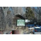
Agate: Agate Myers Pump Company
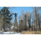
Agate: Agate Water Tower

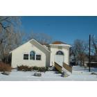
Agate: Agate House
Agate: Agate School
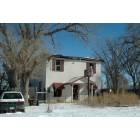
Agate: Agate House
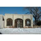
Agate: Agate Grocery
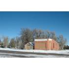
Agate: Agate Elevator
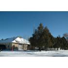
Agate: Agate Community Church

Agate: Agate City Park
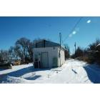
Agate: Agate Myers Pump Company
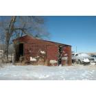
Agate: Agate Barn
- see
15
more - add
your
Submit your own pictures of this place and show them to the world
- OSM Map
- General Map
- Google Map
- MSN Map

| Males: 257 | |
| Females: 261 |
| Median resident age: | 39.2 years |
| Colorado median age: | 34.3 years |
Zip code: 80101
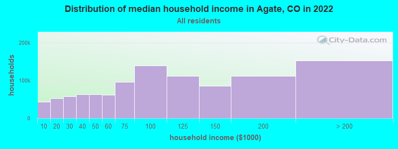
| Agate: | $83,384 |
| CO: | $89,302 |
Estimated per capita income in 2022: $37,212 (it was $16,137 in 2000)
Agate CCD income, earnings, and wages data
Estimated median house or condo value in 2022: $442,495 (it was $146,600 in 2000)
| Agate: | $442,495 |
| CO: | $531,100 |
Mean prices in 2022: all housing units: $641,371; detached houses: $651,849; townhouses or other attached units: $327,498; mobile homes: $135,205
Detailed information about poverty and poor residents in Agate, CO
Compare current foreclosures near Agate, CO:
| Photo | Address | Area | Beds / Baths | Price | Details |
|---|---|---|---|---|---|

|
#1
S 3rd Ave
Deer Trail, CO 80105
|
1,526 sq. feet
|
2 baths 3 beds |
show details | |

|
#2
H Avenue
Limon, CO 80828
|
936 sq. feet
|
1 baths 2 beds |
show details | |

|
#3
S 2nd Ave
Deer Trail, CO 80105
|
- sq. feet
|
- baths - beds |
show details | |

|
#4
4th Ave
Deer Trail, CO 80105
|
- sq. feet
|
- baths - beds |
show details | |

|
Check over 1 million property listings on Foreclosure.com!
|
browse all offers | |||

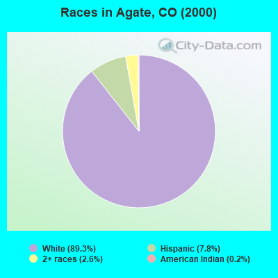
- 41089.3%White alone
- 367.8%Hispanic
- 122.6%Two or more races
- 10.2%American Indian alone
According to our research of Colorado and other state lists, there were 2 registered sex offenders living in Agate, Colorado as of May 11, 2024.
The ratio of all residents to sex offenders in Agate is 259 to 1.
 Recent articles from our blog. Our writers, many of them Ph.D. graduates or candidates, create easy-to-read articles on a wide variety of topics.
Current Local Time: MST time zone
Elevation: 5458 feet
Land area: 594.8 square miles.
Population density: 0.9 people per square mile (very low).

| Agate CCD: | 0.3% ($383) |
| Colorado: | 0.7% ($1,132) |
Nearest city with pop. 50,000+: South Aurora, CO (48.8 miles  , pop. 297,828).
Nearest city with pop. 1,000,000+: Phoenix, AZ (606.4 miles , pop. 1,321,045).
Nearest cities:
), Latitude: 39.39 N, Longitude: 103.96 W
Area code: 719

| Here: | 2.7% |
| Colorado: | 3.2% |
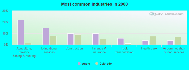
- Agriculture, forestry, fishing & hunting (21.7%)
- Educational services (14.6%)
- Construction (9.9%)
- Finance & insurance (9.9%)
- Truck transportation (5.7%)
- Health care (3.8%)
- Accommodation & food services (3.8%)
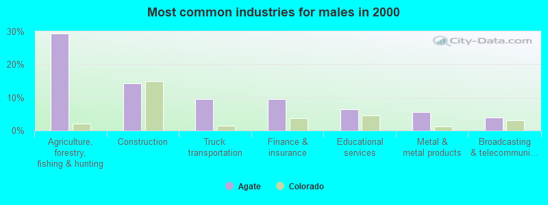
- Agriculture, forestry, fishing & hunting (29.4%)
- Construction (14.3%)
- Truck transportation (9.5%)
- Finance & insurance (9.5%)
- Educational services (6.3%)
- Metal & metal products (5.6%)
- Broadcasting & telecommunications (4.0%)
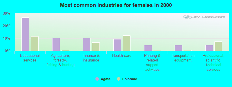
- Educational services (26.7%)
- Agriculture, forestry, fishing & hunting (10.5%)
- Finance & insurance (10.5%)
- Health care (9.3%)
- Printing & related support activities (4.7%)
- Transportation equipment (4.7%)
- Professional, scientific, technical services (4.7%)
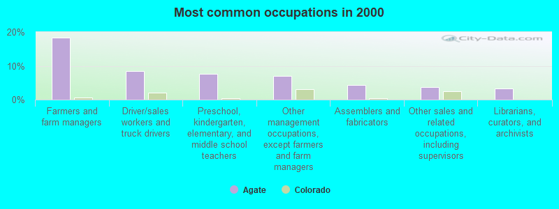
- Farmers and farm managers (18.4%)
- Driver/sales workers and truck drivers (8.5%)
- Preschool, kindergarten, elementary, and middle school teachers (7.5%)
- Other management occupations, except farmers and farm managers (7.1%)
- Assemblers and fabricators (4.2%)
- Other sales and related occupations, including supervisors (3.8%)
- Librarians, curators, and archivists (3.3%)
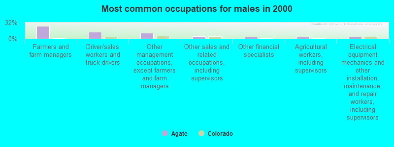
- Farmers and farm managers (25.4%)
- Driver/sales workers and truck drivers (13.5%)
- Other management occupations, except farmers and farm managers (11.9%)
- Other sales and related occupations, including supervisors (4.8%)
- Other financial specialists (4.0%)
- Agricultural workers, including supervisors (4.0%)
- Electrical equipment mechanics and other installation, maintenance, and repair workers, including supervisors (4.0%)
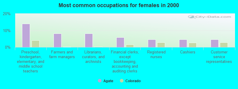
- Preschool, kindergarten, elementary, and middle school teachers (14.0%)
- Farmers and farm managers (8.1%)
- Librarians, curators, and archivists (8.1%)
- Financial clerks, except bookkeeping, accounting and auditing clerks (5.8%)
- Registered nurses (4.7%)
- Cashiers (4.7%)
- Customer service representatives (4.7%)
Average climate in Agate, Colorado
Based on data reported by over 4,000 weather stations


Tornado activity:
Agate-area historical tornado activity is above Colorado state average. It is 32% greater than the overall U.S. average.
On 6/6/1990, a category F3 (max. wind speeds 158-206 mph) tornado 11.2 miles away from the Agate place center caused between $500 and $5000 in damages.
On 6/6/1990, a category F3 tornado 17.1 miles away from the place center injured 14 people and caused between $5,000,000 and $50,000,000 in damages.
Earthquake activity:
Agate-area historical earthquake activity is significantly above Colorado state average. It is 635% greater than the overall U.S. average.On 8/18/1959 at 06:37:13, a magnitude 7.7 (7.7 UK, Class: Major, Intensity: VIII - XII) earthquake occurred 496.0 miles away from the city center, causing $26,000,000 total damage
On 8/23/2011 at 05:46:18, a magnitude 5.3 (5.3 MW, Depth: 2.5 mi, Class: Moderate, Intensity: VI - VII) earthquake occurred 166.2 miles away from Agate center
On 10/18/1984 at 15:30:23, a magnitude 5.5 (5.4 MB, 5.1 MS, 5.5 ML) earthquake occurred 223.8 miles away from the city center
On 8/10/2005 at 22:08:22, a magnitude 5.0 (5.0 MW, Depth: 3.1 mi) earthquake occurred 175.8 miles away from the city center
On 8/10/2005 at 22:08:22, a magnitude 5.0 (5.0 MB, 4.7 MS, 5.0 MW) earthquake occurred 176.7 miles away from Agate center
On 10/28/1983 at 14:06:06, a magnitude 7.3 (6.2 MB, 7.3 MS, 7.0 MW) earthquake occurred 601.6 miles away from the city center, causing 2 deaths (2 shaking deaths) and 3 injuries, causing $15,000,000 total damage
Magnitude types: body-wave magnitude (MB), local magnitude (ML), surface-wave magnitude (MS), moment magnitude (MW)
Natural disasters:
The number of natural disasters in Elbert County (11) is smaller than the US average (15).Major Disasters (Presidential) Declared: 6
Emergencies Declared: 4
Causes of natural disasters: Floods: 5, Storms: 3, Landslides: 2, Mudslides: 2, Snows: 2, Tornadoes: 2, Drought: 1, Fire: 1, Heavy Rain: 1, Hurricane: 1, Snowstorm: 1, Other: 1 (Note: some incidents may be assigned to more than one category).
Airports located in Agate:
- Metrogro Farm Airport (CO25) (Runways: 1)
Colleges/universities with over 2000 students nearest to Agate:
- Community College of Aurora (about 50 miles; Aurora, CO; Full-time enrollment: 4,730)
- Jones International University (about 51 miles; Centennial, CO; FT enrollment: 2,556)
- Colorado State University-Global Campus (about 53 miles; Greenwood Village, CO; FT enrollment: 3,642)
- United States Air Force Academy (about 57 miles; USAFA, CO; FT enrollment: 5,088)
- University of Colorado Colorado Springs (about 57 miles; Colorado Springs, CO; FT enrollment: 8,700)
- University of Denver (about 58 miles; Denver, CO; FT enrollment: 9,621)
- Colorado Technical University-Colorado Springs (about 59 miles; Colorado Springs, CO; FT enrollment: 2,049)
Public elementary/middle school in Agate:
- AGATE ELEMENTARY SCHOOL (Students: 17, Location: 41032 2ND AVENUE, Grades: KG-5)
Points of interest:
Notable locations in Agate: Kuhns Crossing (A), Brittingham Ranch (B), River Bend (C), Agate Volunteer Fire Department (D), North Central Fire Protection District (E). Display/hide their locations on the map
Cemeteries: River Bend Cemetery (1), Norton Cemetery (2), Gair Cemetery (3). Display/hide their locations on the map
Reservoirs: Agate Number 1 Reservoir (A), Walter Burns Detention Reservoir (B), John Brittingham Reservoir (C), Frank Ehman Detention Reservoir Number 2 (D), Shirley Detention Reservoir Number 1 (E), Frank Ehman Detention Reservoir (F), M H Number 2 Reservoir (G), Ball Reservoir (H). Display/hide their locations on the map
Creeks: Reed Springs Creek (A), Bland Creek (B), Key Creek (C), Agate Creek (D). Display/hide their locations on the map
Drinking water stations with addresses in Agate and their reported violations in the past:
AGATE WA (Population served: 70, Groundwater):Past health violations:Past monitoring violations:
- MCL, Monthly (TCR) - In JUL-2011, Contaminant: Coliform. Follow-up actions: St Public Notif requested (JUL-25-2011), St Violation/Reminder Notice (JUL-25-2011), St Compliance achieved (JAN-31-2012), St Public Notif received (FEB-16-2012)
- Follow-up Or Routine LCR Tap M/R - In OCT-01-2011, Contaminant: Lead and Copper Rule. Follow-up actions: St Public Notif requested (DEC-15-2011), St Violation/Reminder Notice (DEC-15-2011), St Public Notif received (JAN-06-2012), St Compliance achieved (SEP-07-2012)
- Follow-up Or Routine LCR Tap M/R - In OCT-01-2007, Contaminant: Lead and Copper Rule. Follow-up actions: St Public Notif requested (JAN-30-2008), St Violation/Reminder Notice (JAN-30-2008), St Compliance achieved (FEB-02-2009)
- Monitoring, Repeat Major (TCR) - In AUG-2007, Contaminant: Coliform (TCR). Follow-up actions: St Public Notif requested (AUG-24-2007), St Violation/Reminder Notice (AUG-24-2007), St Public Notif received (AUG-31-2007), St Compliance achieved (MAR-31-2008)
- Monitoring and Reporting (DBP) - Between JUL-2006 and SEP-2006, Contaminant: Chlorine. Follow-up actions: St Violation/Reminder Notice (DEC-18-2006), St Compliance achieved (JAN-30-2007)
- Monitoring and Reporting (DBP) - Between JAN-2005 and DEC-2005, Contaminant: Total Haloacetic Acids (HAA5). Follow-up actions: St Violation/Reminder Notice (MAR-28-2006), St Public Notif requested (MAR-28-2006), St AO (w/o penalty) issued (NOV-30-2006), St Public Notif requested (NOV-30-2006), St Public Notif received (JAN-12-2007), St Compliance achieved (JAN-12-2007)
- 33 regular monitoring violations
- One other older monitoring violation
| This place: | 2.3 people |
| Colorado: | 2.5 people |
| This place: | 73.0% |
| Whole state: | 63.9% |
| This place: | 6.1% |
| Whole state: | 6.5% |
Likely homosexual households (counted as self-reported same-sex unmarried-partner households)
- Lesbian couples: 0.9% of all households
- Gay men: 0.0% of all households
| This place: | 5.0% |
| Whole state: | 9.3% |
| This place: | 1.5% |
| Whole state: | 4.1% |
For population 15 years and over in Agate:
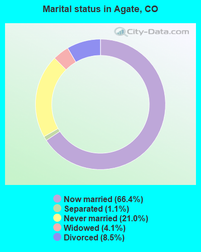
- Never married: 21.0%
- Now married: 66.4%
- Separated: 1.1%
- Widowed: 4.1%
- Divorced: 8.5%
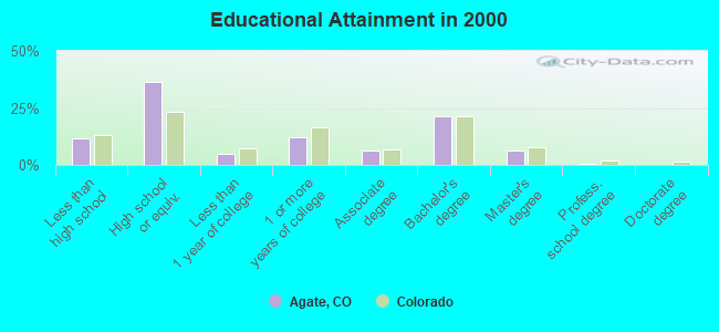
For population 25 years and over in Agate:
- High school or higher: 88.3%
- Bachelor's degree or higher: 28.2%
- Graduate or professional degree: 7.0%
- Unemployed: 4.9%
- Mean travel time to work (commute): 29.0 minutes
| Here: | 9.7 |
| Colorado average: | 11.8 |
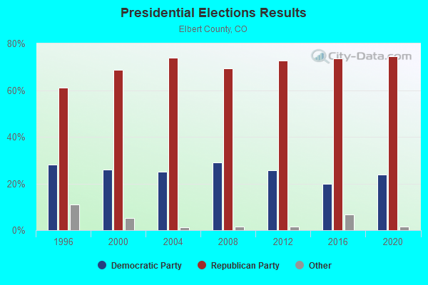
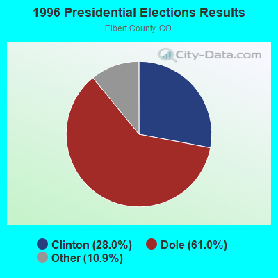
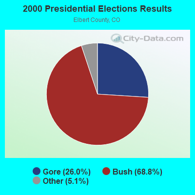
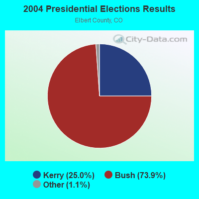
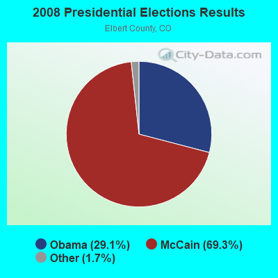
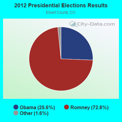
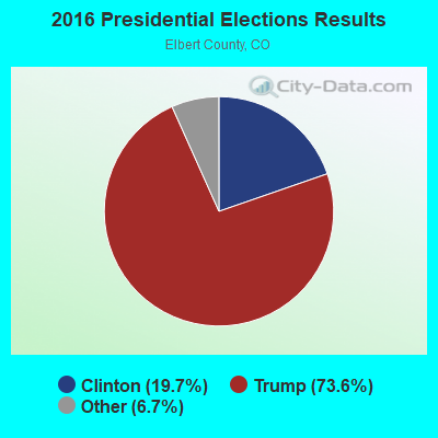
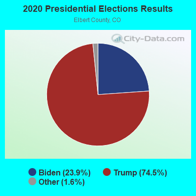
Graphs represent county-level data. Detailed 2008 Election Results
Religion statistics for Agate, CO (based on Elbert County data)
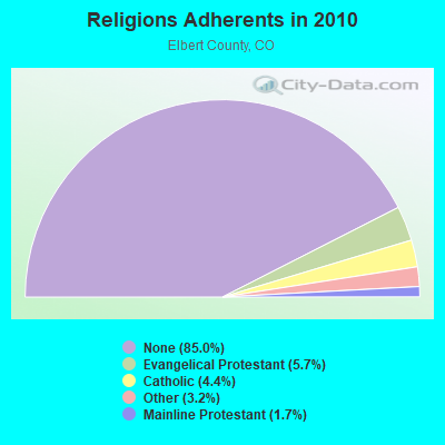
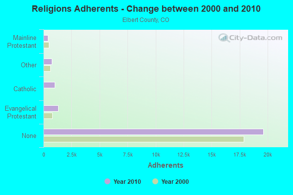
| Religion | Adherents | Congregations |
|---|---|---|
| Evangelical Protestant | 1,317 | 13 |
| Catholic | 1,022 | 1 |
| Other | 744 | 2 |
| Mainline Protestant | 384 | 7 |
| None | 19,619 | - |
Food Environment Statistics:
| Elbert County: | 0.44 / 10,000 pop. |
| Colorado: | 1.50 / 10,000 pop. |
| Elbert County: | 1.77 / 10,000 pop. |
| State: | 3.13 / 10,000 pop. |
| Here: | 3.97 / 10,000 pop. |
| State: | 8.99 / 10,000 pop. |
| This county: | 4.8% |
| Colorado: | 5.3% |
| Elbert County: | 17.4% |
| Colorado: | 18.4% |
Strongest AM radio stations in Agate:
- KOA (850 AM; 50 kW; DENVER, CO; Owner: JACOR BROADCASTING OF COLORADO, INC.)
- KMXA (1090 AM; 50 kW; AURORA, CO; Owner: ENTRAVISION HOLDINGS, LLC)
- KLTT (670 AM; 50 kW; COMMERCE CITY, CO; Owner: KLZ RADIO, INC.)
- KKZN (760 AM; 50 kW; THORNTON, CO; Owner: JACOR BROADCASTING OF COLORADO, INC.)
- KSIR (1010 AM; 25 kW; BRUSH, CO; Owner: JMS BROADCASTING, LLC)
- KCUV (1510 AM; 25 kW; LITTLETON, CO; Owner: PEOPLE WIRELESS, INC.)
- KLMO (1060 AM; 30 kW; LONGMONT, CO; Owner: PILGRIM COMMUNICATIONS, INC.)
- KCBR (1040 AM; daytime; 15 kW; MONUMENT, CO; Owner: KLZ RADIO, INC.)
- KNRC (1150 AM; 10 kW; ENGLEWOOD, CO; Owner: NRC BROADCASTING, INC.)
- KCMN (1530 AM; 15 kW; COLORADO SPRINGS, CO)
- KRKS (990 AM; 10 kW; DENVER, CO; Owner: SALEM MEDIA OF COLORADO, INC.)
- KEZW (1430 AM; 10 kW; AURORA, CO; Owner: ENTERCOM DENVER LICENSE, LLC)
- KIMB (1260 AM; 50 kW; KIMBALL, NE; Owner: G & L INVESTMENTS, LLC)
Strongest FM radio stations in Agate:
- KAVD (103.1 FM; LIMON, CO; Owner: THE MEADOWLARK GROUP, INC.)
- KBRU-FM (101.7 FM; FORT MORGAN, CO; Owner: ON-AIR FAMILY, LLC)
- KJMN (92.1 FM; CASTLE ROCK, CO; Owner: ENTRAVISION HOLDINGS, LLC)
- K220IK (91.9 FM; LIMON, CO; Owner: CALVARY CHAPEL OF TWIN FALLS, INC.)
- KCCY (96.9 FM; PUEBLO, CO; Owner: CAPSTAR TX LIMITED PARTNERSHIP)
- KKMG (98.9 FM; PUEBLO, CO; Owner: CITADEL BROADCASTING COMPANY)
- KKFM (98.1 FM; COLORADO SPRINGS, CO; Owner: CITADEL BROADCASTING COMPANY)
- KYZX (103.9 FM; PUEBLO WEST, CO; Owner: COLORADO SPRINGS RADIO B/CASTRS, INC)
- KBIQ (102.7 FM; MANITOU SPRINGS, CO; Owner: BISON MEDIA, INC.)
- KKCS-FM (101.9 FM; COLORADO SPRINGS, CO; Owner: WALTON STATIONS - COLORADO, INC.)
- KRCC (91.5 FM; COLORADO SPRINGS, CO; Owner: THE COLORADO COLLEGE)
- KSKX (105.5 FM; SECURITY, CO; Owner: OPTIMA COMMUNICATIONS, INC.)
- KKLI (106.3 FM; WIDEFIELD, CO; Owner: CAPSTAR TX LIMITED PARTNERSHIP)
- KGFT (100.7 FM; PUEBLO, CO; Owner: BISON MEDIA, INC)
- KTLF (90.5 FM; COLORADO SPRINGS, CO; Owner: EDUCATIONAL COMMUNICATIONS OF COLORADO SPRINGS, INC.)
- KMOM (96.1 FM; FOUNTAIN, CO; Owner: AMFM TEXAS LICENSES LIMITED PARTNERSHIP)
- KSPZ (92.9 FM; COLORADO SPRINGS, CO; Owner: CITADEL BROADCASTING COMPANY)
- KVUU (99.9 FM; PUEBLO, CO; Owner: CAPSTAR TX LIMITED PARTNERSHIP)
- KCME (88.7 FM; MANITOU SPRINGS, CO; Owner: CHEYENNE MOUNTAIN PUBLIC BROADCAST HOUSE, INC)
- KQMT (99.5 FM; DENVER, CO; Owner: ENTERCOM DENVER LICENSE, LLC)
FCC Registered Cell Phone Towers:
2 (See the full list of FCC Registered Cell Phone Towers in Agate)FCC Registered Antenna Towers:
12 (See the full list of FCC Registered Antenna Towers)FCC Registered Broadcast Land Mobile Towers:
2- 41032 2nd Ave Agate School Bldg (Lat: 39.807472 Lon: -103.013556), Call Sign: KNCW663, Licensee ID: L00489818,
Assigned Frequencies: 47.4600 MHz, Grant Date: 12/02/1996, Expiration Date: 02/11/2002, Cancellation Date: 04/02/2002, Registrant: Agate School District 300, Agate, CO 80101, Phone: (719) 764-2741
- 8 Mi Se (Lat: 39.472194 Lon: -103.933833), Call Sign: KNFE261,
Assigned Frequencies: 151.865 MHz, Grant Date: 12/20/1996, Expiration Date: 02/05/2002, Cancellation Date: 05/05/2002, Registrant: Edward T Butler, Box 1, Agate, CO 80101, Phone: (719) 764-2334
FCC Registered Microwave Towers:
5- AGATE, 39520 County Road 153 (Agate #35353) (Lat: 39.439806 Lon: -103.937667), Type: Tower, Structure height: 102.1 m, Overall height: 106.7 m, Call Sign: WQMY330,
Assigned Frequencies: 11395.0 MHz, 11325.0 MHz, Grant Date: 10/06/2020, Expiration Date: 11/05/2030, Certifier: Jeff Kisner, Registrant: Lukas, Lafuria, Gutierrez & Sachs, LLP, 8300 Greensboro Drive, Suite 1200, Tysons, VA 22102, Phone: (703) 584-8671, Fax: (703) 584-8686, Email:
- DN03323C, 39520 County Road 153 (Agate #35353) (Lat: 39.439806 Lon: -103.937667), Type: Gtower, Structure height: 102.1 m, Overall height: 106.7 m, Call Sign: WQWD807,
Assigned Frequencies: 11465.0 MHz, 11465.0 MHz, 11465.0 MHz, 11465.0 MHz, 11465.0 MHz, 11465.0 MHz, 11465.0 MHz, 11465.0 MHz, 11465.0 MHz, 11465.0 MHz... (+19 more), Grant Date: 07/27/2015, Expiration Date: 07/27/2025, Certifier: David Werblow, Registrant: T-Mobile Usa, Inc., 12920 Se 38th Street, Bellevue, WA 98006, Phone: (425) 383-8401, Fax: (425) 383-4040, Email:
- AGATE, 39520 County Road 153 (Lat: 39.439806 Lon: -103.937667), Type: Gtower, Structure height: 102.1 m, Overall height: 106.7 m, Call Sign: WQYF709,
Assigned Frequencies: 6034.15 MHz, 6063.80 MHz, 6093.45 MHz, 6152.75 MHz, 5974.85 MHz, 6123.10 MHz, Grant Date: 09/13/2016, Expiration Date: 09/13/2026, Certifier: John E Monday, Registrant: At&t Services, Inc., 208 S Akard St, 20f, Dallas, TX 75202, Phone: (855) 699-7073, Email:
- Bijou Creek, Bijou Creek, 14.0 Miles W Of (Lat: 39.403556 Lon: -104.216194), Type: Gtower, Structure height: 27.4 m, Call Sign: WRBX821,
Assigned Frequencies: 10785.0 MHz, 5974.85 MHz, Grant Date: 07/19/2018, Expiration Date: 07/19/2028, Certifier: Mike Garland, Registrant: Utility Telecom Consulting Group, Inc., 9850 S Maryland Pkwy, A5-108, Las Vegas, NV 89183, Phone: (702) 340-1706, Email:
- BIJOU CREEK, 14.0 Miles West Of Agate Co (Lat: 39.403028 Lon: -104.216889), Type: Tower, Structure height: 27.4 m, Call Sign: WEF406, Licensee ID: L00097088,
Assigned Frequencies: 6625.00 MHz, 6665.00 MHz, 6595.00 MHz, 6034.15 MHz, 6063.80 MHz, Grant Date: 06/01/2012, Expiration Date: 06/13/2022, Cancellation Date: 06/26/2017, Registrant: Tri State Generation & Transmission Association Inc
FCC Registered Amateur Radio Licenses:
13 (See the full list of FCC Registered Amateur Radio Licenses in Agate)FAA Registered Aircraft:
4- Aircraft: PIPER PA-38-112 (Category: Land, Seats: 2, Weight: Up to 12,499 Pounds, Speed: 183 mph), Engine: LYCOMING 0-235 SERIES (115 HP) (4 Cycle)
N-Number: 2541B, N2541B, N-2541B, Serial Number: 38-79A0117, Year manufactured: 1978, Airworthiness Date: 11/01/1978, Certificate Issue Date: 04/17/2020
Registrant (Individual): Randy L Clark, 41130 1st Ave, Agate, CO 80101 - Aircraft: BALLOON WORKS FIREFLY 7 (Category: Land, Weight: Up to 12,499 Pounds, Speed: 63 mph), Engine: None
N-Number: 74168, N74168, N-74168, Serial Number: F7-306, Airworthiness Date: 03/13/1986, Certificate Issue Date: 03/23/2004
Registrant (Individual): Daniel P Aglar, 23267 E Lost Creek Trl, Agate, CO 80101 - Aircraft: CESSNA 150 (Category: Land, Seats: 2, Weight: Up to 12,499 Pounds, Speed: 90 mph), Engine: Reciprocating
N-Number: 7979E, N7979E, N-7979E, Serial Number: 17779, Certificate Issue Date: 01/06/2011
Registrant (Individual): Daniel P Aglar, 23267 E Lost Creek Trail, Agate, CO 80101 - Aircraft: HELICYCLE/MORRISEY R R RM-1 (Category: Land, Weight: Up to 12,499 Pounds), Engine: AMA/EXPR UNKNOWN ENG (Turbo-shaft)
N-Number: 867TV, N867TV, N-867TV, Serial Number: 007, Year manufactured: 2006, Airworthiness Date: 03/08/2006, Certificate Issue Date: 01/05/2016
Registrant (LLC): Turbine V LLC, Po Box 34, Agate, CO 80101
Deregistered: Cancel Date: 05/06/2019
2004 - 2018 National Fire Incident Reporting System (NFIRS) incidents
- Fire incident types reported to NFIRS in Agate, CO
- 11866.7%Outside Fires
- 3922.0%Mobile Property/Vehicle Fires
- 1910.7%Structure Fires
- 10.6%Other
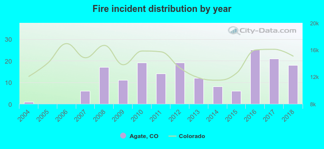 According to the data from the years 2004 - 2018 the average number of fires per year is 12. The highest number of reported fire incidents - 25 took place in 2016, and the least - 0 in 2005. The data has a rising trend.
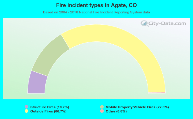 When looking into fire subcategories, the most incidents belonged to: Outside Fires (66.7%), and Mobile Property/Vehicle Fires (22.0%).
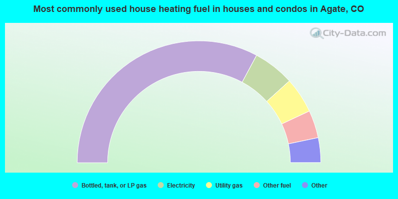
- 65.7%Bottled, tank, or LP gas
- 10.9%Electricity
- 9.5%Utility gas
- 7.3%Other fuel
- 3.6%Wood
- 1.5%Fuel oil, kerosene, etc.
- 1.5%Coal or coke
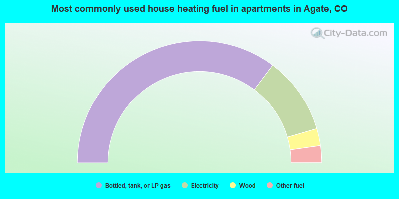
- 70.5%Bottled, tank, or LP gas
- 20.5%Electricity
- 4.5%Wood
- 4.5%Other fuel
Agate compared to Colorado state average:
- Unemployed percentage below state average.
- Black race population percentage significantly below state average.
- Hispanic race population percentage below state average.
- Foreign-born population percentage significantly below state average.
- Renting percentage below state average.
- Length of stay since moving in significantly above state average.
- Number of rooms per house significantly below state average.
- House age significantly below state average.
Agate on our top lists:
- #45 on the list of "Top 101 larger cities with the lowest real estate taxes percentage (population 50,000+)"
- #80 on the list of "Top 101 counties with the lowest number of deaths per 1000 residents 2007-2013"