Bridge Statistics for Zilwaukee, Michigan (MI)
Condition, Traffic, Stress, Structural Evaluation, Project Costs
- National Bridge Inventory (NBI) Statistics
- 24Number of bridges
- 1,873ft / 571mTotal length
- $410,000Total costs
- 365,179Total average daily traffic
- 25,657Total average daily truck traffic
- National Bridge Inventory (NBI) Registered Bridges for Zilwaukee
- No street view available for this location
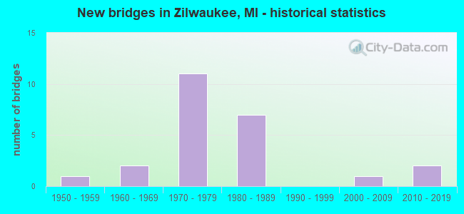
- New bridges - historical statistics
- 11950-1959
- 21960-1969
- 111970-1979
- 71980-1989
- 12000-2009
- 22010-2019

- Reconstructed bridges - Historical Statistics
- 22000-2009
- 22010-2019


- Bridge Condition - Deck
- 21.4%Very good
- 21.4%Good
- 42.9%Satisfactory
- 14.3%Fair

- Bridge Condition - Superstructure
- 35.7%Very good
- 7.1%Good
- 50.0%Satisfactory
- 7.1%Fair

- Bridge Condition - Substructure
- 14.3%Very good
- 57.1%Good
- 14.3%Satisfactory
- 14.3%Fair

- Bridge Condition - Channel
- 25.0%Very good
- 37.5%Good
- 25.0%Satisfactory
- 12.5%Fair
Find on map >> Show street view
Structure Number: 599, Location: @ SAGINAW COUNTY LINE (Lat: 43.522958, Lng: -83.939931), Route carried "on" structure: Interstate 75, Year Built: 2010, Status: Open, Structure Length: 0.62m (2.03ft), Average Daily Traffic: 53,002 (year 2007), Truck Traffic: 5%, Average Future Daily Traffic: 75,910 (year 2018), Design Load: Greater than HL93, Features Intersected: GOETZ DRAIN
Minimum Vertical Clearance: 30.48m (100.00ft), Kilometerpoint: 0.023, Lanes on structure: 6, Base Highway Network: Yes (Inventory Route: 76, Subroute: 1), Owner: State Highway Agency, Approaching Roadway Width: 14.6m (47.9ft), Skew: 1 degrees, Material/Design: Concrete, Design/Construction: Culvert, Number Of Spans In Main Unit: 1, Length of Maximum Span: 6.2m (20.3ft), Curb-To-Curb Width: 14.6m (47.9ft), Out-to-Out Width: 48.5m (159.1ft)
Condition: Channel: Very good, Culverts: Very good, Operating Rating: 82.3 metric tons, Method Used To Determine Operating Rating: Load and Resistance Factor Rating (LRFR) rating reported by rating factor(RF) method using HL-93 loadings, Inventory Rating: 63.5 metric tons, Method Used To Determine Inventory Rating: Load and Resistance Factor Rating (LRFR) rating reported by rating factor(RF) method using HL-93 loadings, Structural Evaluation: Equal to present desirable criteria, Deck Geometry: High priority of replacement, Waterway Adequacy: Equal to present desirable criteria, Approach Roadway Alignment: Equal to present desirable criteria, Designated Inspection Frequency: Every 24 months, Inspection Date: November 2021
Find on map >> Show street view
Structure Number: 718, Location: 1.0 MI S OF AMELITH RD (Lat: 43.525908, Lng: -83.934672), Route carried "on" structure: County highway , Year Built: 2016, Status: Open, Structure Length: 1.10m (3.61ft), Average Daily Traffic: 156 (year 2000), Truck Traffic: 10%, Average Future Daily Traffic: 187 (year 2020), Design Load: Greater than HL93, Features Intersected: GOETZ DRAIN, Facility Carried by Structure: TWO MILE ROAD
Minimum Vertical Clearance: 30.48m (100.00ft), Kilometerpoint: 1.651, Lanes on structure: 2, Owner: County Highway Agency, Approaching Roadway Width: 7.0m (23.0ft), Material/Design: Prestressed concrete, Design/Construction: Box Beam or Girders - Multiple, Number Of Spans In Main Unit: 1, Length of Maximum Span: 10.2m (33.5ft), Curb-To-Curb Width: 9.5m (31.2ft), Out-to-Out Width: 10.5m (34.4ft)
Condition: Deck: Very good, Superstructure: Very good, Substructure: Very good, Channel: Good, Operating Rating: 74.5 metric tons, Method Used To Determine Operating Rating: Load and Resistance Factor Rating (LRFR) rating reported by rating factor(RF) method using HL-93 loadings, Inventory Rating: 57.3 metric tons, Method Used To Determine Inventory Rating: Load and Resistance Factor Rating (LRFR) rating reported by rating factor(RF) method using HL-93 loadings, Structural Evaluation: Equal to present desirable criteria, Deck Geometry: Equal to present minimum criteria, Waterway Adequacy: Equal to present minimum criteria, Approach Roadway Alignment: Equal to present desirable criteria, Length Of Structure Improvement: 1.00m (3.28ft), Designated Inspection Frequency: Every 24 months, Inspection Date: June 2020, Bridge Improvement Cost: $168,000, Roadway Improvement Cost: $140,000, Total Project Cost: $340,000, Deck Structure Type: Concrete Cast-file-Place, Wearing Surface/Protective System: Wearing Surface: Monolithic Concrete, Deck Protection: Epoxy Coated Reinforcing
Find on map >> Show street view
Structure Number: 917, Location: 0.8 MI S OF NILES (Lat: 41.801086, Lng: -86.248300), Route carried "on" structure: US 12, Year Built: 1955, Status: Open, Structure Length: 4.80m (15.75ft), Average Daily Traffic: 7,473 (year 2014), Truck Traffic: 10%, Average Future Daily Traffic: 8,594 (year 2034), Design Load: HS 20, Features Intersected: M-51
Minimum Vertical Clearance: 30.48m (100.00ft), Kilometerpoint: 39.837, Lanes on structure: 2, Lanes under structure: 5, Base Highway Network: Yes (Inventory Route: 135, Subroute: 7), Owner: State Highway Agency, Approaching Roadway Width: 9.8m (32.2ft), Material/Design: Steel, Design/Construction: Stringer/Multi-beam, Number Of Spans In Main Unit: 3, Length of Maximum Span: 24.0m (78.7ft), Curb-To-Curb Width: 10.1m (33.1ft), Out-to-Out Width: 11.9m (39.0ft)
Condition: Deck: Fair, Superstructure: Fair, Substructure: Satisfactory, Operating Rating: 58.0 metric tons, Method Used To Determine Operating Rating: Load Factor (LF) rating reported by rating factor (RF) method using MS18 loading, Inventory Rating: 34.7 metric tons, Method Used To Determine Inventory Rating: Load Factor (LF) rating reported by rating factor (RF) method using MS18 loading, Structural Evaluation: Somewhat better than minimum adequacy, Deck Geometry: Somewhat better than minimum adequacy, Underclear: Meets minimum limits, Approach Roadway Alignment: Equal to present desirable criteria, Length Of Structure Improvement: 4.79m (15.72ft), Designated Inspection Frequency: Every 24 months, Inspection Date: August 2020, Bridge Improvement Cost: $233,000, Roadway Improvement Cost: $6,000, Total Project Cost: $70,000, Deck Structure Type: Concrete Cast-file-Place, Wearing Surface/Protective System: Wearing Surface: Bituminous, Membrane: Preformed Fabric
Find on map >> Show street view
Structure Number: 9117, Location: @ N JCT I-75 (Lat: 43.506669, Lng: -83.932550), Route carried "on" structure: Ramp Interstate 75, Year Built: 1971, Status: Open, Structure Length: 2.44m (8.01ft), Average Daily Traffic: 2,200 (year 1988), Truck Traffic: 6%, Average Future Daily Traffic: 1,290 (year 2008), Design Load: HS 20+Mod, Features Intersected: KOCHVILLE DRAIN
Minimum Vertical Clearance: 30.48m (100.00ft), Kilometerpoint: 1.041, Lanes on structure: 2, Owner: State Highway Agency, Approaching Roadway Width: 13.1m (43.0ft), Skew: 1 degrees, Material/Design: Steel, Design/Construction: Stringer/Multi-beam, Number Of Spans In Main Unit: 1, Length of Maximum Span: 24.3m (79.7ft), Curb-To-Curb Width: 12.0m (39.4ft), Out-to-Out Width: 13.0m (42.7ft)
Condition: Deck: Good, Superstructure: Very good, Substructure: Good, Channel: Very good, Operating Rating: 65.4 metric tons, Method Used To Determine Operating Rating: Load Factor (LF) rating reported by rating factor (RF) method using MS18 loading, Inventory Rating: 39.2 metric tons, Method Used To Determine Inventory Rating: Load Factor (LF) rating reported by rating factor (RF) method using MS18 loading, Structural Evaluation: Better than present minimum criteria, Deck Geometry: Superior to present desirable criteria, Waterway Adequacy: Equal to present desirable criteria, Approach Roadway Alignment: Equal to present desirable criteria, Designated Inspection Frequency: Every 24 months, Inspection Date: October 2020, Deck Structure Type: Concrete Cast-file-Place, Wearing Surface/Protective System: Wearing Surface: Epoxy Overlay
Find on map >> Show street view
Structure Number: 9145, Location: 2.6 MI N OF SAGINAW (Lat: 43.479825, Lng: -83.955869), Route carried "on" structure: County highway 2004, Year Built: 1971, Status: Open, Structure Length: 7.32m (24.02ft), Average Daily Traffic: 9,945 (year 1996), Truck Traffic: 3%, Average Future Daily Traffic: 11,540 (year 2006), Design Load: H 20, Features Intersected: I-675, Facility Carried by Structure: TITTABAWASSEE RD
Minimum Vertical Clearance: 30.48m (100.00ft), Kilometerpoint: 33.514, Lanes on structure: 7, Lanes under structure: 6, Base Highway Network: Yes (Inventory Route: 89, Subroute: 2), Owner: State Highway Agency, Approaching Roadway Width: 29.2m (95.8ft), Material/Design: Steel continuous, Design/Construction: Stringer/Multi-beam, Number Of Spans In Main Unit: 2, Length of Maximum Span: 36.6m (120.1ft), Curb-To-Curb Width: 28.8m (94.5ft), Out-to-Out Width: 30.0m (98.4ft)
Condition: Deck: Satisfactory, Superstructure: Good, Substructure: Good, Operating Rating: 68.7 metric tons, Method Used To Determine Operating Rating: Load Factor (LF) rating reported by rating factor (RF) method using MS18 loading, Inventory Rating: 41.1 metric tons, Method Used To Determine Inventory Rating: Load Factor (LF) rating reported by rating factor (RF) method using MS18 loading, Structural Evaluation: Better than present minimum criteria, Deck Geometry: Somewhat better than minimum adequacy, Underclear: High priority of corrective action, Approach Roadway Alignment: Equal to present desirable criteria, Designated Inspection Frequency: Every 24 months, Inspection Date: November 2020, Deck Structure Type: Concrete Cast-file-Place, Wearing Surface/Protective System: Wearing Surface: Epoxy Overlay
Find on map >> Show street view
Structure Number: 9146, Location: 1.0 MI S OF I-75 (Lat: 43.488775, Lng: -83.946047), Route carried "on" structure: County highway 2004, Year Built: 1971, Status: Open, Structure Length: 9.56m (31.36ft), Average Daily Traffic: 4,050 (year 1996), Truck Traffic: 3%, Average Future Daily Traffic: 2,260 (year 2006), Design Load: H 15, Features Intersected: I-675, Facility Carried by Structure: MICHIGAN RD
Minimum Vertical Clearance: 30.48m (100.00ft), Kilometerpoint: 15.078, Lanes on structure: 2, Lanes under structure: 4, Base Highway Network: Yes (Inventory Route: 47, Subroute: 3), Owner: State Highway Agency, Approaching Roadway Width: 14.6m (47.9ft), Skew: 3 degrees, Material/Design: Steel, Design/Construction: Stringer/Multi-beam, Number Of Spans In Main Unit: 4, Length of Maximum Span: 34.7m (113.8ft), Curb-To-Curb Width: 11.7m (38.4ft), Out-to-Out Width: 12.9m (42.3ft)
Condition: Deck: Satisfactory, Superstructure: Satisfactory, Substructure: Good, Operating Rating: 73.5 metric tons, Method Used To Determine Operating Rating: Load Factor (LF) rating reported by rating factor (RF) method using MS18 loading, Inventory Rating: 44.1 metric tons, Method Used To Determine Inventory Rating: Load Factor (LF) rating reported by rating factor (RF) method using MS18 loading, Structural Evaluation: Equal to present minimum criteria, Deck Geometry: Somewhat better than minimum adequacy, Underclear: High priority of corrective action, Approach Roadway Alignment: Equal to present desirable criteria, Designated Inspection Frequency: Every 24 months, Inspection Date: October 2020, Deck Structure Type: Concrete Cast-file-Place, Wearing Surface/Protective System: Wearing Surface: Epoxy Overlay
Find on map >> Show street view
Structure Number: 9147, Location: 0.5 MI S OF I-75 (Lat: 43.494036, Lng: -83.937253), Route carried "on" structure: Interstate 675, Year Built: 1971, Year Reconstructed: 2009, Status: Open, Structure Length: 9.33m (30.61ft), Average Daily Traffic: 3,061 (year 2017), Truck Traffic: 10%, Average Future Daily Traffic: 3,250 (year 2037), Design Load: HS 20+Mod, Features Intersected: KOCHVILLE RD
Minimum Vertical Clearance: 30.48m (100.00ft), Kilometerpoint: 11.951, Lanes on structure: 2, Lanes under structure: 2, Base Highway Network: Yes (Inventory Route: 46, Subroute: 1), Owner: State Highway Agency, Approaching Roadway Width: 12.8m (42.0ft), Skew: 5 degrees, Material/Design: Steel continuous, Design/Construction: Stringer/Multi-beam, Number Of Spans In Main Unit: 3, Length of Maximum Span: 41.6m (136.5ft), Curb-To-Curb Width: 13.2m (43.3ft), Out-to-Out Width: 13.9m (45.6ft)
Condition: Deck: Satisfactory, Superstructure: Satisfactory, Substructure: Fair, Operating Rating: 82.6 metric tons, Method Used To Determine Operating Rating: Load Factor (LF) rating reported by rating factor (RF) method using MS18 loading, Inventory Rating: 49.6 metric tons, Method Used To Determine Inventory Rating: Load Factor (LF) rating reported by rating factor (RF) method using MS18 loading, Structural Evaluation: Somewhat better than minimum adequacy, Deck Geometry: Superior to present desirable criteria, Underclear: Somewhat better than minimum adequacy, Approach Roadway Alignment: Equal to present desirable criteria, Designated Inspection Frequency: Every 24 months, Inspection Date: October 2020, Deck Structure Type: Concrete Cast-file-Place, Wearing Surface/Protective System: Wearing Surface: Epoxy Overlay, Deck Protection: Epoxy Coated Reinforcing
Find on map >> Show street view
Structure Number: 9152, Location: @ N JCT I-75 (Lat: 43.498950, Lng: -83.929992), Route carried "on" structure: Ramp Interstate 675, Year Built: 1971, Year Reconstructed: 2009, Status: Open, Structure Length: 11.50m (37.73ft), Average Daily Traffic: 1,290 (year 1982), Truck Traffic: 6%, Average Future Daily Traffic: 1,290 (year 1977), Design Load: HS 20, Features Intersected: I-75
Minimum Vertical Clearance: 30.48m (100.00ft), Kilometerpoint: 12.761, Lanes on structure: 1, Lanes under structure: 6, Owner: State Highway Agency, Approaching Roadway Width: 8.8m (28.9ft), Skew: 4 degrees, Material/Design: Steel, Design/Construction: Stringer/Multi-beam, Number Of Spans In Main Unit: 4, Length of Maximum Span: 42.5m (139.4ft), Curb-To-Curb Width: 8.2m (26.9ft), Out-to-Out Width: 9.0m (29.5ft)
Condition: Deck: Good, Superstructure: Satisfactory, Substructure: Good, Inventory Rating: 62.0 metric tons, Method Used To Determine Inventory Rating: Load Factor (LF), Structural Evaluation: Equal to present minimum criteria, Deck Geometry: Superior to present desirable criteria, Underclear: Somewhat better than minimum adequacy, Approach Roadway Alignment: Equal to present desirable criteria, Designated Inspection Frequency: Every 24 months, Inspection Date: November 2020, Bridge Improvement Cost: $116,000, Deck Structure Type: Concrete Cast-file-Place, Wearing Surface/Protective System: Wearing Surface: Epoxy Overlay, Deck Protection: Epoxy Coated Reinforcing
Find on map >> Show street view
Structure Number: 9166, Location: 1.0 MI S OF BAY CO LINE (Lat: 43.506286, Lng: -83.933025), Route carried "on" structure: Interstate 75, Year Built: 1960, Year Reconstructed: 2017, Status: Open, Structure Length: 1.58m (5.18ft), Average Daily Traffic: 25,430 (year 2014), Truck Traffic: 6%, Average Future Daily Traffic: 58,489 (year 2034), Design Load: Greater than HL93, Features Intersected: KOCHVILLE DRAIN
Minimum Vertical Clearance: 30.48m (100.00ft), Kilometerpoint: 35.919, Lanes on structure: 3, Base Highway Network: Yes (Inventory Route: 46, Subroute: 3), Owner: State Highway Agency, Approaching Roadway Width: 17.7m (58.1ft), Skew: 3 degrees, Material/Design: Prestressed concrete, Design/Construction: Box Beam or Girders - Single/Spread, Number Of Spans In Main Unit: 1, Length of Maximum Span: 15.0m (49.2ft), Curb-To-Curb Width: 17.7m (58.1ft), Out-to-Out Width: 18.6m (61.0ft)
Condition: Deck: Very good, Superstructure: Very good, Substructure: Fair, Channel: Good, Operating Rating: 55.7 metric tons, Method Used To Determine Operating Rating: Load and Resistance Factor Rating (LRFR) rating reported by rating factor(RF) method using HL-93 loadings, Inventory Rating: 42.8 metric tons, Method Used To Determine Inventory Rating: Load and Resistance Factor Rating (LRFR) rating reported by rating factor(RF) method using HL-93 loadings, Structural Evaluation: Somewhat better than minimum adequacy, Deck Geometry: Better than present minimum criteria, Waterway Adequacy: Equal to present desirable criteria, Approach Roadway Alignment: Equal to present minimum criteria, Designated Inspection Frequency: Every 24 months, Inspection Date: October 2020, Deck Structure Type: Concrete Cast-file-Place, Wearing Surface/Protective System: Wearing Surface: Monolithic Concrete, Deck Protection: Epoxy Coated Reinforcing
Find on map >> Show street view
Structure Number: 9167, Location: 1.0 MI S OF BAY CO LINE (Lat: 43.506061, Lng: -83.933256), Route carried "on" structure: Interstate 75, Year Built: 1960, Year Reconstructed: 2017, Status: Open, Structure Length: 1.58m (5.18ft), Average Daily Traffic: 25,430 (year 2014), Truck Traffic: 6%, Average Future Daily Traffic: 58,489 (year 2034), Design Load: Greater than HL93, Features Intersected: KOCHVILLE DRAIN
Minimum Vertical Clearance: 30.48m (100.00ft), Kilometerpoint: 35.898, Lanes on structure: 4, Base Highway Network: Yes (Inventory Route: 46, Subroute: 2), Owner: State Highway Agency, Approaching Roadway Width: 21.3m (69.9ft), Skew: 3 degrees, Material/Design: Prestressed concrete, Design/Construction: Box Beam or Girders - Single/Spread, Number Of Spans In Main Unit: 1, Length of Maximum Span: 15.0m (49.2ft), Curb-To-Curb Width: 21.3m (69.9ft), Out-to-Out Width: 22.3m (73.2ft)
Condition: Deck: Very good, Superstructure: Very good, Substructure: Very good, Channel: Good, Operating Rating: 55.4 metric tons, Method Used To Determine Operating Rating: Load and Resistance Factor Rating (LRFR) rating reported by rating factor(RF) method using HL-93 loadings, Inventory Rating: 39.9 metric tons, Method Used To Determine Inventory Rating: Load and Resistance Factor Rating (LRFR) rating reported by rating factor(RF) method using HL-93 loadings, Structural Evaluation: Equal to present desirable criteria, Deck Geometry: Better than present minimum criteria, Waterway Adequacy: Equal to present desirable criteria, Approach Roadway Alignment: Equal to present minimum criteria, Designated Inspection Frequency: Every 24 months, Inspection Date: October 2020, Deck Structure Type: Concrete Cast-file-Place, Wearing Surface/Protective System: Wearing Surface: Monolithic Concrete, Deck Protection: Epoxy Coated Reinforcing
Find on map >> Show street view
Structure Number: 9168, Location: AT ZILWAUKEE (Lat: 43.478792, Lng: -83.906411), Route carried "on" structure: Interstate 75, Year Built: 1980, Status: Open, Structure Length: 245.70m (806.10ft), Average Daily Traffic: 23,450 (year 2007), Truck Traffic: 7%, Average Future Daily Traffic: 34,201 (year 2018), Design Load: HS 25 or greater, Features Intersected: SAGINAW R, M13, GTWRR
Minimum Vertical Clearance: 30.48m (100.00ft), Kilometerpoint: 32.000, Lanes on structure: 4, Lanes under structure: 3, Base Highway Network: Yes (Inventory Route: 46, Subroute: 3), Owner: State Highway Agency, Approaching Roadway Width: 19.5m (64.0ft), Navigation Control: Yes ( Vertical Clearance: 0.3m (1.0ft), Horizontal Clearance: 91.4m (299.9ft)), Material/Design: Prestressed concrete continuous, Design/Construction: Segmental Box Girder, Number Of Spans In Main Unit: 25, Length of Maximum Span: 119.5m (392.1ft), Curb-To-Curb Width: 22.0m (72.2ft), Out-to-Out Width: 22.7m (74.5ft)
Condition: Deck: Satisfactory, Superstructure: Satisfactory, Substructure: Good, Channel: Satisfactory, Operating Rating: 42.8 metric tons, Method Used To Determine Operating Rating: Load and Resistance Factor Rating (LRFR) rating reported by rating factor(RF) method using HL-93 loadings, Inventory Rating: 26.2 metric tons, Method Used To Determine Inventory Rating: Load and Resistance Factor Rating (LRFR) rating reported by rating factor(RF) method using HL-93 loadings, Structural Evaluation: Equal to present minimum criteria, Deck Geometry: Better than present minimum criteria, Underclear: Superior to present desirable criteria, Waterway Adequacy: Equal to present desirable criteria, Approach Roadway Alignment: Equal to present desirable criteria, Designated Inspection Frequency: Every 24 months, Underwater Inspection Frequency: Every 60 months, Inspection Date: October 2021, Underwater Inspection Date: September 2020, Deck Structure Type: Concrete Cast-file-Place, Wearing Surface/Protective System: Wearing Surface: Latex Concrete, Deck Protection: Epoxy Coated Reinforcing
Find on map >> Show street view
Structure Number: 9169, Location: AT ZILWAUKEE (Lat: 43.478539, Lng: -83.906436), Route carried "on" structure: Interstate 75, Year Built: 1984, Status: Open, Structure Length: 246.43m (808.50ft), Average Daily Traffic: 23,450 (year 2007), Truck Traffic: 7%, Average Future Daily Traffic: 34,201 (year 2018), Design Load: HS 25 or greater, Features Intersected: SAGINAW R, M-13, GTWRR
Minimum Vertical Clearance: 30.48m (100.00ft), Kilometerpoint: 31.964, Lanes on structure: 4, Lanes under structure: 3, Base Highway Network: Yes (Inventory Route: 46, Subroute: 2), Owner: State Highway Agency, Approaching Roadway Width: 19.5m (64.0ft), Navigation Control: Yes ( Vertical Clearance: 0.3m (1.0ft), Horizontal Clearance: 91.4m (299.9ft)), Material/Design: Prestressed concrete continuous, Design/Construction: Segmental Box Girder, Number Of Spans In Main Unit: 26, Length of Maximum Span: 119.5m (392.1ft), Curb-To-Curb Width: 22.0m (72.2ft), Out-to-Out Width: 22.7m (74.5ft)
Condition: Deck: Satisfactory, Superstructure: Satisfactory, Substructure: Good, Channel: Satisfactory, Operating Rating: 35.0 metric tons, Method Used To Determine Operating Rating: Load and Resistance Factor Rating (LRFR) rating reported by rating factor(RF) method using HL-93 loadings, Inventory Rating: 11.7 metric tons, Method Used To Determine Inventory Rating: Load and Resistance Factor Rating (LRFR) rating reported by rating factor(RF) method using HL-93 loadings, Structural Evaluation: High priority of corrective action, Deck Geometry: Better than present minimum criteria, Underclear: Superior to present desirable criteria, Waterway Adequacy: Equal to present desirable criteria, Approach Roadway Alignment: Equal to present desirable criteria, Designated Inspection Frequency: Every 24 months, Underwater Inspection Frequency: Every 60 months, Inspection Date: October 2020, Underwater Inspection Date: September 2020, Deck Structure Type: Concrete Cast-file-Place, Wearing Surface/Protective System: Wearing Surface: Latex Concrete, Deck Protection: Epoxy Coated Reinforcing
Find on map >> Show street view
Structure Number: 917, Location: AT ZILWAUKEE (Lat: 43.487703, Lng: -83.924786), Route carried "on" structure: Ramp Interstate 75, Year Built: 1984, Status: Open, Structure Length: 19.75m (64.80ft), Average Daily Traffic: 4,100 (year 1988), Truck Traffic: 12%, Average Future Daily Traffic: 4,000 (year 1977), Design Load: HS 25 or greater, Features Intersected: LAND FOR RAISED RAMP
Minimum Vertical Clearance: 30.48m (100.00ft), Kilometerpoint: 0.441, Lanes on structure: 1, Owner: State Highway Agency, Approaching Roadway Width: 9.1m (29.9ft), Material/Design: Prestressed concrete continuous, Design/Construction: Segmental Box Girder, Number Of Spans In Main Unit: 4, Length of Maximum Span: 74.0m (242.8ft), Curb-To-Curb Width: 8.3m (27.2ft), Out-to-Out Width: 8.9m (29.2ft)
Condition: Deck: Satisfactory, Superstructure: Satisfactory, Substructure: Good, Operating Rating: 41.8 metric tons, Method Used To Determine Operating Rating: Load and Resistance Factor Rating (LRFR) rating reported by rating factor(RF) method using HL-93 loadings, Inventory Rating: 31.1 metric tons, Method Used To Determine Inventory Rating: Load and Resistance Factor Rating (LRFR) rating reported by rating factor(RF) method using HL-93 loadings, Structural Evaluation: Equal to present minimum criteria, Deck Geometry: Superior to present desirable criteria, Approach Roadway Alignment: Equal to present desirable criteria, Designated Inspection Frequency: Every 24 months, Inspection Date: October 2021, Deck Structure Type: Concrete Cast-file-Place, Wearing Surface/Protective System: Wearing Surface: Latex Concrete, Deck Protection: Epoxy Coated Reinforcing
Find on map >> Show street view
Structure Number: 9172, Location: 1.7 MI NW OF M-13 (Lat: 43.493983, Lng: -83.927908), Route carried "on" structure: County highway 2004, Year Built: 1980, Status: Open, Structure Length: 7.62m (25.00ft), Average Daily Traffic: 2,059 (year 1997), Truck Traffic: 3%, Average Future Daily Traffic: 500 (year 1977), Design Load: H 20, Features Intersected: I-75, Facility Carried by Structure: KOCHVILLE RD
Minimum Vertical Clearance: 30.48m (100.00ft), Kilometerpoint: 10.012, Lanes on structure: 2, Lanes under structure: 8, Owner: State Highway Agency, Approaching Roadway Width: 14.0m (45.9ft), Material/Design: Steel continuous, Design/Construction: Stringer/Multi-beam, Number Of Spans In Main Unit: 2, Length of Maximum Span: 38.1m (125.0ft), Curb-To-Curb Width: 13.2m (43.3ft), Out-to-Out Width: 13.9m (45.6ft)
Condition: Deck: Fair, Superstructure: Satisfactory, Substructure: Satisfactory, Operating Rating: 66.1 metric tons, Method Used To Determine Operating Rating: Load Factor (LF) rating reported by rating factor (RF) method using MS18 loading, Inventory Rating: 39.5 metric tons, Method Used To Determine Inventory Rating: Load Factor (LF) rating reported by rating factor (RF) method using MS18 loading, Structural Evaluation: Equal to present minimum criteria, Deck Geometry: Equal to present minimum criteria, Underclear: Somewhat better than minimum adequacy, Approach Roadway Alignment: Equal to present desirable criteria, Designated Inspection Frequency: Every 24 months, Inspection Date: July 2021, Deck Structure Type: Concrete Cast-file-Place, Wearing Surface/Protective System: Wearing Surface: Latex Concrete, Deck Protection: Epoxy Coated Reinforcing
Find on map >> Show street view
Structure Number: 923, Location: 0.4 MI E OF N MICHIGAN (Lat: 43.494058, Lng: -83.938139), Route carried "on" structure: County highway 7382, Year Built: 2001, Status: Open, Structure Length: 1.45m (4.76ft), Average Daily Traffic: 3,437 (year 2018), Truck Traffic: 10%, Average Future Daily Traffic: 3,609 (year 2028), Design Load: HS 20, Features Intersected: KOCHVILLE DRAIN, Facility Carried by Structure: KOCHVILLE ROAD
Minimum Vertical Clearance: 30.48m (100.00ft), Kilometerpoint: 9.185, Lanes on structure: 2, Owner: County Highway Agency, Approaching Roadway Width: 11.9m (39.0ft), Skew: 1 degrees, Material/Design: Prestressed concrete, Design/Construction: Box Beam or Girders - Single/Spread, Number Of Spans In Main Unit: 1, Length of Maximum Span: 13.0m (42.7ft), Curb-To-Curb Width: 12.5m (41.0ft), Out-to-Out Width: 13.4m (44.0ft)
Condition: Deck: Good, Superstructure: Very good, Substructure: Good, Channel: Fair, Operating Rating: 59.9 metric tons, Method Used To Determine Operating Rating: Load Factor (LF) rating reported by rating factor (RF) method using MS18 loading, Inventory Rating: 36.0 metric tons, Method Used To Determine Inventory Rating: Load Factor (LF) rating reported by rating factor (RF) method using MS18 loading, Structural Evaluation: Better than present minimum criteria, Deck Geometry: Equal to present minimum criteria, Waterway Adequacy: Equal to present desirable criteria, Approach Roadway Alignment: Equal to present desirable criteria, Designated Inspection Frequency: Every 24 months, Inspection Date: July 2020, Deck Structure Type: Concrete Precast Panels, Wearing Surface/Protective System: Wearing Surface: Monolithic Concrete, Deck Protection: Epoxy Coated Reinforcing
Find on map >> Show street view
Structure Number: 9145, Location: 2.6 MI N OF SAGINAW (Lat: 43.479825, Lng: -83.955869), Route carried "under" structure: Interstate 675, Year Built: 1971, Structure Length: 0. m, Average Daily Traffic: 26,064 (year 2017), Truck Traffic: 6%, Features Intersected: I-675, Facility Carried by Structure: TITTABAWASSEE RD
Minimum Vertical Clearance: 4.62m (15.16ft), Kilometerpoint: 9.421, Lanes on structure: 7, Lanes under structure: 6, Material/Design: Steel continuous, Design/Construction: Stringer/Multi-beam, Length of Maximum Span: 36.6m (120.1ft)
Find on map >> Show street view
Structure Number: 9146, Location: 1.0 MI S OF I-75 (Lat: 43.488775, Lng: -83.946047), Route carried "under" structure: Interstate 675, Year Built: 1971, Structure Length: 0. m, Average Daily Traffic: 6,125 (year 2017), Truck Traffic: 10%, Features Intersected: I-675, Facility Carried by Structure: MICHIGAN RD
Minimum Vertical Clearance: 4.52m (14.83ft), Kilometerpoint: 10.735, Lanes on structure: 2, Lanes under structure: 4, Material/Design: Steel, Design/Construction: Stringer/Multi-beam, Length of Maximum Span: 34.7m (113.8ft)
Find on map >> Show street view
Structure Number: 9147, Location: 0.5 MI S OF I-75 (Lat: 43.494036, Lng: -83.937253), Route carried "under" structure: County highway 7382, Year Built: 1971, Structure Length: 0. m, Average Daily Traffic: 2,110 (year 1997), Features Intersected: KOCHVILLE RD, Facility Carried by Structure: I-675 SB
Minimum Vertical Clearance: 4.40m (14.44ft), Kilometerpoint: 9.257, Lanes on structure: 2, Lanes under structure: 2, Material/Design: Steel continuous, Design/Construction: Stringer/Multi-beam, Length of Maximum Span: 41.6m (136.5ft)
Find on map >> Show street view
Structure Number: 9148, Location: N JCT I-75 (Lat: 43.498453, Lng: -83.929783), Route carried "under" structure: Interstate 75, Year Built: 1971, Structure Length: 0. m, Average Daily Traffic: 38,878 (year 2007), Truck Traffic: 11%, Features Intersected: I-75
Minimum Vertical Clearance: 5.33m (17.49ft), Kilometerpoint: 34.969, Lanes on structure: 2, Lanes under structure: 6, Material/Design: Steel, Design/Construction: Stringer/Multi-beam, Length of Maximum Span: 39.5m (129.6ft)
Find on map >> Show street view
Structure Number: 915, Location: 0.5 MI S OF I-75 (Lat: 43.494025, Lng: -83.936669), Route carried "under" structure: County highway 7382, Year Built: 1971, Structure Length: 0. m, Average Daily Traffic: 2,110 (year 1997), Features Intersected: KOCHVILLE RD, Facility Carried by Structure: I-675 NB
Minimum Vertical Clearance: 4.90m (16.08ft), Kilometerpoint: 9.304, Lanes on structure: 2, Lanes under structure: 2, Material/Design: Steel continuous, Design/Construction: Stringer/Multi-beam, Length of Maximum Span: 41.6m (136.5ft)
Find on map >> Show street view
Structure Number: 9152, Location: @ N JCT I-75 (Lat: 43.498950, Lng: -83.929992), Route carried "under" structure: Interstate 75, Year Built: 1971, Structure Length: 0. m, Average Daily Traffic: 52,000 (year 2007), Truck Traffic: 5%, Features Intersected: I-75
Minimum Vertical Clearance: 5.23m (17.16ft), Kilometerpoint: 35.054, Lanes on structure: 1, Lanes under structure: 6, Material/Design: Steel, Design/Construction: Stringer/Multi-beam, Length of Maximum Span: 42.5m (139.4ft)
Find on map >> Show street view
Structure Number: 9168, Location: AT ZILWAUKEE (Lat: 43.478792, Lng: -83.906411), Route carried "under" structure: State highway 13, Year Built: 1980, Structure Length: 0. m, Average Daily Traffic: 6,208 (year 2007), Truck Traffic: 6%, Features Intersected: SAGINAW R, M13, GTWRR, Facility Carried by Structure: I-75 NB
Minimum Vertical Clearance: 6.68m (21.92ft), Kilometerpoint: 3.265, Lanes on structure: 4, Lanes under structure: 3, Material/Design: Prestressed concrete continuous, Design/Construction: Segmental Box Girder, Length of Maximum Span: 119.5m (392.1ft)
Find on map >> Show street view
Structure Number: 9169, Location: AT ZILWAUKEE (Lat: 43.478539, Lng: -83.906436), Route carried "under" structure: State highway 13, Year Built: 1984, Structure Length: 0. m, Average Daily Traffic: 4,273 (year 2007), Truck Traffic: 9%, Features Intersected: SAGINAW R, M-13, GTWRR, Facility Carried by Structure: I-75 SB
Minimum Vertical Clearance: 6.68m (21.92ft), Kilometerpoint: 3.237, Lanes on structure: 4, Lanes under structure: 3, Material/Design: Prestressed concrete continuous, Design/Construction: Segmental Box Girder, Length of Maximum Span: 119.5m (392.1ft)
Find on map >> Show street view
Structure Number: 9172, Location: 1.7 MI NW OF M-13 (Lat: 43.493983, Lng: -83.927908), Route carried "under" structure: Interstate 75, Year Built: 1980, Structure Length: 0. m, Average Daily Traffic: 38,878 (year 2007), Truck Traffic: 11%, Features Intersected: I-75, Facility Carried by Structure: KOCHVILLE RD
Minimum Vertical Clearance: 5.61m (18.41ft), Kilometerpoint: 34.478, Lanes on structure: 2, Lanes under structure: 8, Material/Design: Steel continuous, Design/Construction: Stringer/Multi-beam, Length of Maximum Span: 38.1m (125.0ft)