Bridge Statistics for Zeigler, Illinois (IL)
Condition, Traffic, Stress, Structural Evaluation, Project Costs
- National Bridge Inventory (NBI) Statistics
- 10Number of bridges
- 89ft / 26.7mTotal length
- 6,700Total average daily traffic
- 515Total average daily truck traffic
- 8,392Total future (year 2032) average daily traffic
- National Bridge Inventory (NBI) Registered Bridges for Zeigler
- No street view available for this location
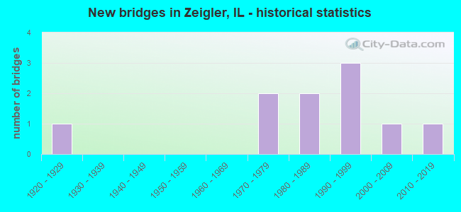
- New bridges - historical statistics
- 11920-1929
- 21970-1979
- 21980-1989
- 31990-1999
- 12000-2009
- 12010-2019


- Bridge Condition - Deck
- 50.0%Very good
- 20.0%Good
- 30.0%Satisfactory

- Bridge Condition - Superstructure
- 40.0%Very good
- 30.0%Good
- 20.0%Satisfactory
- 10.0%Poor

- Bridge Condition - Substructure
- 60.0%Very good
- 40.0%Good

- Bridge Condition - Channel
- 10.0%Excellent
- 40.0%Very good
- 50.0%Good
Find on map >> Show street view
Structure Number: 280037, Location: 1.6 MI E ZEIGLER (Lat: 37.891550, Lng: -89.021103), Route carried "on" structure: State highway 149, Year Built: 1928, Year Reconstructed: 1988, Status: Open, Structure Length: 13.80m (45.28ft), Average Daily Traffic: 2,600 (year 2021), Truck Traffic: 6%, Average Future Daily Traffic: 3,442 (year 2032), Design Load: HS 20, Features Intersected: BIG MUDDY RIVER
Minimum Vertical Clearance: 30+ m (98+ ft), Kilometerpoint: 50.452, Lanes on structure: 2, Base Highway Network: Yes, Owner: State Highway Agency, Approaching Roadway Width: 7.3m (24.0ft), Material/Design: Steel continuous, Design/Construction: Stringer/Multi-beam, Number Of Spans In Main Unit: 6, Length of Maximum Span: 26.2m (86.0ft), Curb-To-Curb Width: 9.8m (32.2ft), Out-to-Out Width: 10.7m (35.1ft)
Condition: Deck: Satisfactory, Superstructure: Poor, Substructure: Good, Channel: Good, Operating Rating: 76.1 metric tons, Method Used To Determine Operating Rating: Load Factor (LF) rating reported by rating factor (RF) method using MS18 loading, Inventory Rating: 40.8 metric tons, Method Used To Determine Inventory Rating: Load Factor (LF) rating reported by rating factor (RF) method using MS18 loading, Structural Evaluation: Meets minimum limits, Deck Geometry: Meets minimum limits, Waterway Adequacy: Equal to present desirable criteria, Approach Roadway Alignment: Equal to present desirable criteria, Designated Inspection Frequency: Every 12 months, Inspection Date: January 2022, Deck Structure Type: Concrete Cast-file-Place, Wearing Surface/Protective System: Deck Protection: Epoxy Coated Reinforcing
Find on map >> Show street view
Structure Number: 28007, Location: 2 MI E IL 184 (Lat: 37.891850, Lng: -89.080044), Route carried "on" structure: State highway 149, Year Built: 1999, Status: Open, Structure Length: 3.21m (10.53ft), Average Daily Traffic: 2,850 (year 2021), Truck Traffic: 6%, Average Future Daily Traffic: 3,124 (year 2032), Design Load: HS 20, Features Intersected: PRAIRIE CREEK
Minimum Vertical Clearance: 30+ m (98+ ft), Kilometerpoint: 44.819, Lanes on structure: 2, Base Highway Network: Yes, Owner: State Highway Agency, Approaching Roadway Width: 7.3m (24.0ft), Material/Design: Concrete continuous, Design/Construction: Slab, Number Of Spans In Main Unit: 3, Length of Maximum Span: 11.5m (37.7ft), Curb-To-Curb Width: 10.8m (35.4ft), Out-to-Out Width: 11.8m (38.7ft)
Condition: Deck: Satisfactory, Superstructure: Satisfactory, Substructure: Very good, Channel: Very good, Operating Rating: 84.9 metric tons, Method Used To Determine Operating Rating: Load Factor (LF) rating reported by rating factor (RF) method using MS18 loading, Inventory Rating: 50.9 metric tons, Method Used To Determine Inventory Rating: Load Factor (LF) rating reported by rating factor (RF) method using MS18 loading, Structural Evaluation: Equal to present minimum criteria, Deck Geometry: Somewhat better than minimum adequacy, Waterway Adequacy: Equal to present desirable criteria, Approach Roadway Alignment: Equal to present desirable criteria, Designated Inspection Frequency: Every 24 months, Inspection Date: Febuary 2022, Deck Structure Type: Concrete Cast-file-Place, Wearing Surface/Protective System: Deck Protection: Epoxy Coated Reinforcing
Find on map >> Show street view
Structure Number: 283218, Location: JIM BROWNING RD (Lat: 37.913964, Lng: -89.082767), Route carried "on" structure: County highway , Year Built: 1979, Status: Open, Structure Length: 1.34m (4.40ft), Average Daily Traffic: 350 (year 2019), Truck Traffic: 22%, Average Future Daily Traffic: 371 (year 2032), Features Intersected: PRARIE CK, Facility Carried by Structure: CH 14
Minimum Vertical Clearance: 30+ m (98+ ft), Kilometerpoint: 2.768, Lanes on structure: 2, Owner: County Highway Agency, Approaching Roadway Width: 9.8m (32.2ft), Material/Design: Prestressed concrete, Design/Construction: Box Beam or Girders - Multiple, Number Of Spans In Main Unit: 1, Length of Maximum Span: 13.4m (44.0ft), Curb-To-Curb Width: 9.1m (29.9ft), Out-to-Out Width: 9.3m (30.5ft)
Condition: Deck: Good, Superstructure: Good, Substructure: Good, Channel: Good, Operating Rating: 66.4 metric tons, Method Used To Determine Operating Rating: Load Factor (LF) rating reported by rating factor (RF) method using MS18 loading, Inventory Rating: 39.9 metric tons, Method Used To Determine Inventory Rating: Load Factor (LF) rating reported by rating factor (RF) method using MS18 loading, Structural Evaluation: Better than present minimum criteria, Deck Geometry: Equal to present minimum criteria, Waterway Adequacy: Equal to present desirable criteria, Approach Roadway Alignment: Equal to present desirable criteria, Designated Inspection Frequency: Every 48 months, Inspection Date: July 2018, Deck Structure Type: Concrete Precast Panels, Wearing Surface/Protective System: Wearing Surface: Bituminous
Find on map >> Show street view
Structure Number: 283219, Location: JIM BROWNING RD (Lat: 37.913844, Lng: -89.074300), Route carried "on" structure: County highway , Year Built: 1979, Status: Open, Structure Length: 0.80m (2.62ft), Average Daily Traffic: 450 (year 2019), Truck Traffic: 19%, Average Future Daily Traffic: 741 (year 2032), Features Intersected: PRAIRE CK, Facility Carried by Structure: CH 14
Minimum Vertical Clearance: 30+ m (98+ ft), Kilometerpoint: 3.508, Lanes on structure: 2, Owner: County Highway Agency, Approaching Roadway Width: 9.8m (32.2ft), Material/Design: Concrete, Design/Construction: Channel Beam, Number Of Spans In Main Unit: 1, Length of Maximum Span: 7.9m (25.9ft), Curb-To-Curb Width: 9.1m (29.9ft), Out-to-Out Width: 9.1m (29.9ft)
Condition: Deck: Good, Superstructure: Good, Substructure: Good, Channel: Good, Operating Rating: 59.9 metric tons, Method Used To Determine Operating Rating: Load Factor (LF) rating reported by rating factor (RF) method using MS18 loading, Inventory Rating: 36.0 metric tons, Method Used To Determine Inventory Rating: Load Factor (LF) rating reported by rating factor (RF) method using MS18 loading, Structural Evaluation: Better than present minimum criteria, Deck Geometry: Equal to present minimum criteria, Waterway Adequacy: Equal to present desirable criteria, Approach Roadway Alignment: Equal to present desirable criteria, Designated Inspection Frequency: Every 48 months, Inspection Date: July 2018, Deck Structure Type: Concrete Precast Panels, Wearing Surface/Protective System: Wearing Surface: Bituminous
Find on map >> Show street view
Structure Number: 283236, Location: TR 299 OV PRAIRIE CK (Lat: 37.925131, Lng: -89.088828), Route carried "on" structure: County highway , Year Built: 1981, Status: Open, Structure Length: 1.43m (4.69ft), Average Daily Traffic: 25 (year 2019), Truck Traffic: 20%, Average Future Daily Traffic: 26 (year 2032), Design Load: HS 20, Features Intersected: PRAIRIE CREEK, Facility Carried by Structure: TR 299
Minimum Vertical Clearance: 30+ m (98+ ft), Kilometerpoint: 0.595, Lanes on structure: 2, Owner: Town or Township Highway Agency, Approaching Roadway Width: 6.7m (22.0ft), Material/Design: Prestressed concrete, Design/Construction: Box Beam or Girders - Multiple, Number Of Spans In Main Unit: 1, Length of Maximum Span: 13.4m (44.0ft), Curb-To-Curb Width: 7.4m (24.3ft), Out-to-Out Width: 7.4m (24.3ft)
Condition: Deck: Very good, Superstructure: Good, Substructure: Very good, Channel: Good, Operating Rating: 59.6 metric tons, Method Used To Determine Operating Rating: Load Factor (LF) rating reported by rating factor (RF) method using MS18 loading, Inventory Rating: 35.6 metric tons, Method Used To Determine Inventory Rating: Load Factor (LF) rating reported by rating factor (RF) method using MS18 loading, Structural Evaluation: Better than present minimum criteria, Deck Geometry: Equal to present minimum criteria, Waterway Adequacy: Better than present minimum criteria, Approach Roadway Alignment: Equal to present desirable criteria, Designated Inspection Frequency: Every 48 months, Inspection Date: June 2021, Deck Structure Type: Concrete Precast Panels, Wearing Surface/Protective System: Wearing Surface: Gravel
Find on map >> Show street view
Structure Number: 28329, Location: 1.25 MI W IL 148 (Lat: 37.906550, Lng: -89.080892), Route carried "on" structure: County highway , Year Built: 1989, Status: Open, Structure Length: 1.83m (6.00ft), Average Daily Traffic: 100 (year 2019), Truck Traffic: 10%, Average Future Daily Traffic: 318 (year 2032), Design Load: HS 20, Features Intersected: PRAIRIE CREEK, Facility Carried by Structure: TR 335
Minimum Vertical Clearance: 30+ m (98+ ft), Kilometerpoint: 6.131, Lanes on structure: 2, Owner: Town or Township Highway Agency, Approaching Roadway Width: 8.5m (27.9ft), Material/Design: Prestressed concrete, Design/Construction: Box Beam or Girders - Multiple, Number Of Spans In Main Unit: 1, Length of Maximum Span: 17.5m (57.4ft), Curb-To-Curb Width: 7.4m (24.3ft), Out-to-Out Width: 7.4m (24.3ft)
Condition: Deck: Very good, Superstructure: Very good, Substructure: Very good, Channel: Very good, Operating Rating: 44.4 metric tons, Method Used To Determine Operating Rating: Assigned rating based on Load Factor Design (LFD) reported by rating factor (RF) using MS18 loading, Inventory Rating: 32.4 metric tons, Method Used To Determine Inventory Rating: Assigned rating based on Load Factor Design (LFD) reported by rating factor (RF) using MS18 loading, Structural Evaluation: Equal to present desirable criteria, Deck Geometry: Equal to present minimum criteria, Waterway Adequacy: Equal to present desirable criteria, Approach Roadway Alignment: Equal to present desirable criteria, Designated Inspection Frequency: Every 48 months, Inspection Date: July 2018, Deck Structure Type: Concrete Precast Panels, Wearing Surface/Protective System: Wearing Surface: Gravel
Find on map >> Show street view
Structure Number: 283356, Location: 1 MI NW ZEIGLER (Lat: 37.921253, Lng: -89.073106), Route carried "on" structure: County highway , Year Built: 1999, Status: Open, Structure Length: 1.12m (3.67ft), Average Daily Traffic: 25 (year 2019), Truck Traffic: 8%, Average Future Daily Traffic: 26 (year 2032), Design Load: HS 20, Features Intersected: TRIB TO PRAIRIE CR, Facility Carried by Structure: TR 303 - CRANE RD
Minimum Vertical Clearance: 30+ m (98+ ft), Kilometerpoint: 0.740, Lanes on structure: 2, Owner: Town or Township Highway Agency, Approaching Roadway Width: 4.9m (16.1ft), Material/Design: Prestressed concrete, Design/Construction: Box Beam or Girders - Multiple, Number Of Spans In Main Unit: 1, Length of Maximum Span: 10.4m (34.1ft), Curb-To-Curb Width: 7.4m (24.3ft), Out-to-Out Width: 7.4m (24.3ft)
Condition: Deck: Very good, Superstructure: Very good, Substructure: Very good, Channel: Very good, Operating Rating: 44.1 metric tons, Method Used To Determine Operating Rating: Assigned rating based on Load Factor Design (LFD) reported by rating factor (RF) using MS18 loading, Inventory Rating: 32.4 metric tons, Method Used To Determine Inventory Rating: Assigned rating based on Load Factor Design (LFD) reported by rating factor (RF) using MS18 loading, Structural Evaluation: Equal to present desirable criteria, Deck Geometry: Equal to present minimum criteria, Waterway Adequacy: Equal to present desirable criteria, Approach Roadway Alignment: Equal to present desirable criteria, Designated Inspection Frequency: Every 48 months, Inspection Date: July 2018, Deck Structure Type: Concrete Precast Panels, Wearing Surface/Protective System: Wearing Surface: Gravel
Find on map >> Show street view
Structure Number: 283393, Location: 350N 450E (Lat: 37.914444, Lng: -89.072292), Route carried "on" structure: County highway , Year Built: 2007, Status: Open, Structure Length: 0.81m (2.66ft), Average Daily Traffic: 75 (year 2019), Truck Traffic: 13%, Average Future Daily Traffic: 106 (year 2032), Design Load: HS 20, Features Intersected: PRAIRIE CREEK TRIB, Facility Carried by Structure: BLACKBIRD ROAD
Minimum Vertical Clearance: 30+ m (98+ ft), Kilometerpoint: 2.382, Lanes on structure: 2, Owner: Town or Township Highway Agency, Approaching Roadway Width: 5.5m (18.0ft), Material/Design: Prestressed concrete, Design/Construction: Box Beam or Girders - Multiple, Number Of Spans In Main Unit: 1, Length of Maximum Span: 7.3m (24.0ft), Curb-To-Curb Width: 7.3m (24.0ft), Out-to-Out Width: 7.3m (24.0ft)
Condition: Deck: Very good, Superstructure: Very good, Substructure: Very good, Channel: Very good, Operating Rating: 44.1 metric tons, Method Used To Determine Operating Rating: Assigned rating based on Load Factor Design (LFD) reported by rating factor (RF) using MS18 loading, Inventory Rating: 32.4 metric tons, Method Used To Determine Inventory Rating: Assigned rating based on Load Factor Design (LFD) reported by rating factor (RF) using MS18 loading, Structural Evaluation: Equal to present desirable criteria, Deck Geometry: Equal to present minimum criteria, Waterway Adequacy: Equal to present desirable criteria, Approach Roadway Alignment: Superior to present desirable criteria, Designated Inspection Frequency: Every 48 months, Inspection Date: September 2021, Deck Structure Type: Concrete Precast Panels
Find on map >> Show street view
Structure Number: 283405, Location: 0.88MI S RENFRO LAKE (Lat: 37.923206, Lng: -89.072403), Route carried "on" structure: County highway , Year Built: 2010, Status: Open, Structure Length: 1.11m (3.64ft), Average Daily Traffic: 50 (year 2019), Average Future Daily Traffic: 53 (year 2032), Design Load: HS 25 or greater, Features Intersected: TRIB TO PRAIRIE CR, Facility Carried by Structure: BLACKBIRD RD
Minimum Vertical Clearance: 30+ m (98+ ft), Kilometerpoint: 1.416, Lanes on structure: 2, Owner: Town or Township Highway Agency, Approaching Roadway Width: 4.9m (16.1ft), Material/Design: Prestressed concrete, Design/Construction: Box Beam or Girders - Multiple, Number Of Spans In Main Unit: 1, Length of Maximum Span: 10.4m (34.1ft), Curb-To-Curb Width: 7.3m (24.0ft), Out-to-Out Width: 7.3m (24.0ft)
Condition: Deck: Very good, Superstructure: Very good, Substructure: Very good, Channel: Excellent, Operating Rating: 44.1 metric tons, Method Used To Determine Operating Rating: Assigned rating based on Load Factor Design (LFD) reported by rating factor (RF) using MS18 loading, Inventory Rating: 32.4 metric tons, Method Used To Determine Inventory Rating: Assigned rating based on Load Factor Design (LFD) reported by rating factor (RF) using MS18 loading, Structural Evaluation: Equal to present desirable criteria, Deck Geometry: Equal to present minimum criteria, Waterway Adequacy: Superior to present desirable criteria, Approach Roadway Alignment: Superior to present desirable criteria, Designated Inspection Frequency: Every 48 months, Inspection Date: November 2019, Deck Structure Type: Concrete Precast Panels
Find on map >> Show street view
Structure Number: 286003, Location: ZEIGLER (Lat: 37.901378, Lng: -89.055969), Route carried "on" structure: City street , Year Built: 1995, Status: Open, Structure Length: 1.28m (4.20ft), Average Daily Traffic: 175 (year 2014), Average Future Daily Traffic: 185 (year 2032), Design Load: HS 20, Features Intersected: TRIB TO PRAIRIE CR, Facility Carried by Structure: CS 1082-MARYLAND
Minimum Vertical Clearance: 30+ m (98+ ft), Kilometerpoint: 0.161, Lanes on structure: 2, Owner: City or Municipal Highway Agency, Approaching Roadway Width: 6.7m (22.0ft), Skew: 3 degrees, Material/Design: Prestressed concrete, Design/Construction: Box Beam or Girders - Multiple, Number Of Spans In Main Unit: 1, Length of Maximum Span: 12.0m (39.4ft), Curb-To-Curb Width: 7.4m (24.3ft), Out-to-Out Width: 7.4m (24.3ft)
Condition: Deck: Satisfactory, Superstructure: Satisfactory, Substructure: Good, Channel: Good, Operating Rating: 44.1 metric tons, Method Used To Determine Operating Rating: Assigned rating based on Load Factor Design (LFD) reported by rating factor (RF) using MS18 loading, Inventory Rating: 32.4 metric tons, Method Used To Determine Inventory Rating: Assigned rating based on Load Factor Design (LFD) reported by rating factor (RF) using MS18 loading, Structural Evaluation: Equal to present minimum criteria, Deck Geometry: Somewhat better than minimum adequacy, Waterway Adequacy: Equal to present desirable criteria, Approach Roadway Alignment: Equal to present desirable criteria, Designated Inspection Frequency: Every 24 months, Inspection Date: July 2020, Deck Structure Type: Concrete Precast Panels, Wearing Surface/Protective System: Wearing Surface: Bituminous