Bridge Statistics for Yorkville, Wisconsin (WI)
Condition, Traffic, Stress, Structural Evaluation, Project Costs
- National Bridge Inventory (NBI) Statistics
- 26Number of bridges
- 210ft / 63.6mTotal length
- $3,693,000Total costs
- 428,229Total average daily traffic
- 42,634Total average daily truck traffic
- National Bridge Inventory (NBI) Registered Bridges for Yorkville
- No street view available for this location
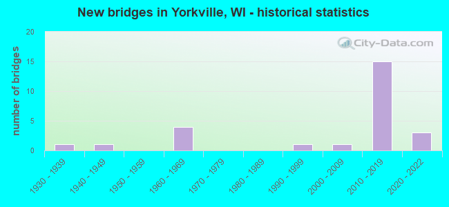
- New bridges - historical statistics
- 11930-1939
- 11940-1949
- 41960-1969
- 11990-1999
- 12000-2009
- 152010-2019
- 32020-2022


- Bridge Condition - Deck
- 5.9%Excellent
- 35.3%Very good
- 35.3%Good
- 5.9%Satisfactory
- 5.9%Fair
- 5.9%Poor
- 5.9%Serious

- Bridge Condition - Superstructure
- 16.7%Excellent
- 38.9%Very good
- 22.2%Good
- 5.6%Satisfactory
- 5.6%Fair
- 11.1%Poor

- Bridge Condition - Substructure
- 11.1%Excellent
- 50.0%Very good
- 16.7%Good
- 11.1%Satisfactory
- 5.6%Fair
- 5.6%Poor

- Bridge Condition - Channel
- 16.7%Excellent
- 41.7%Very good
- 33.3%Good
- 8.3%Satisfactory
Find on map >> Show street view
Structure Number: B510059, Location: 2.2 MI E JCT USH 45 (Lat: 42.734103, Lng: -88.010375), Route carried "on" structure: State highway 20, Year Built: 1968, Year Reconstructed: 2020, Status: Open, Structure Length: 1.86m (6.10ft), Average Daily Traffic: 9,600 (year 2020), Truck Traffic: 5%, Average Future Daily Traffic: 11,600 (year 2040), Design Load: H 20, Features Intersected: W BR ROOT RIVER CANAL
Minimum Vertical Clearance: 30+ m (98+ ft), Kilometerpoint: 0.000, Lanes on structure: 2, Base Highway Network: Yes, Owner: State Highway Agency, Approaching Roadway Width: 13.4m (44.0ft), Skew: 1 degrees, Material/Design: Prestressed concrete, Design/Construction: Stringer/Multi-beam, Number Of Spans In Main Unit: 1, Length of Maximum Span: 18.0m (59.1ft), Curb-To-Curb Width: 13.4m (44.0ft), Out-to-Out Width: 14.3m (46.9ft)
Condition: Deck: Good, Superstructure: Good, Substructure: Good, Channel: Very good, Operating Rating: 53.9 metric tons, Method Used To Determine Operating Rating: Load Factor (LF), Inventory Rating: 30.8 metric tons, Method Used To Determine Inventory Rating: Load Factor (LF), Structural Evaluation: Better than present minimum criteria, Deck Geometry: Equal to present minimum criteria, Waterway Adequacy: Equal to present desirable criteria, Approach Roadway Alignment: Equal to present desirable criteria, Designated Inspection Frequency: Every 24 months, Inspection Date: April 2020, Deck Structure Type: Concrete Cast-file-Place, Wearing Surface/Protective System: Wearing Surface: Monolithic Concrete, Deck Protection: Epoxy Coated Reinforcing
Find on map >> Show street view
Structure Number: B510081, Location: 1.9M E JCT USH 45 (Lat: 42.709961, Lng: -88.015161), Route carried "on" structure: County highway , Year Built: 1994, Status: Open, Structure Length: 1.49m (4.89ft), Average Daily Traffic: 2,600 (year 2019), Truck Traffic: 5%, Average Future Daily Traffic: 5,946 (year 2039), Design Load: HS 20, Features Intersected: W. BR. ROOT RIVER CANAL, Facility Carried by Structure: CTH C
Minimum Vertical Clearance: 30+ m (98+ ft), Kilometerpoint: 0.000, Lanes on structure: 2, Owner: County Highway Agency, Approaching Roadway Width: 9.1m (29.9ft), Material/Design: Concrete, Design/Construction: Slab, Number Of Spans In Main Unit: 1, Length of Maximum Span: 14.3m (46.9ft), Curb-To-Curb Width: 12.2m (40.0ft), Out-to-Out Width: 12.8m (42.0ft)
Condition: Deck: Satisfactory, Superstructure: Satisfactory, Substructure: Good, Channel: Good, Operating Rating: 65.0 metric tons, Method Used To Determine Operating Rating: Load Factor (LF), Inventory Rating: 38.9 metric tons, Method Used To Determine Inventory Rating: Load Factor (LF), Structural Evaluation: Equal to present minimum criteria, Deck Geometry: Equal to present minimum criteria, Waterway Adequacy: Better than present minimum criteria, Approach Roadway Alignment: Equal to present desirable criteria, Designated Inspection Frequency: Every 24 months, Inspection Date: October 2020, Deck Structure Type: Concrete Cast-file-Place, Wearing Surface/Protective System: Wearing Surface: Monolithic Concrete, Deck Protection: Epoxy Coated Reinforcing
Find on map >> Show street view
Structure Number: B51012, Location: 0.1MI N OF STH 20 (Lat: 42.765447, Lng: -88.210650), Route carried "on" structure: City street , Year Built: 2007, Status: Open, Structure Length: 2.33m (7.64ft), Average Daily Traffic: 532 (year 2019), Average Future Daily Traffic: 585 (year 2039), Design Load: HS 25 or greater, Features Intersected: FOX R, Facility Carried by Structure: LRD FOX ISLE DR
Minimum Vertical Clearance: 30+ m (98+ ft), Kilometerpoint: 0.000, Lanes on structure: 2, Owner: Town or Township Highway Agency, Approaching Roadway Width: 7.3m (24.0ft), Material/Design: Concrete, Design/Construction: Slab, Number Of Spans In Main Unit: 2, Length of Maximum Span: 11.3m (37.1ft), Curb or Sidewalk Widths: Left: 2.0m (6.6ft), Right: 0.0m, Curb-To-Curb Width: 7.3m (24.0ft), Out-to-Out Width: 10.0m (32.8ft)
Condition: Deck: Good, Superstructure: Good, Substructure: Very good, Channel: Very good, Operating Rating: 90.0 metric tons, Method Used To Determine Operating Rating: Load Factor (LF), Inventory Rating: 53.5 metric tons, Method Used To Determine Inventory Rating: Load Factor (LF), Structural Evaluation: Better than present minimum criteria, Deck Geometry: Meets minimum limits, Waterway Adequacy: Equal to present desirable criteria, Approach Roadway Alignment: Equal to present minimum criteria, Designated Inspection Frequency: Every 48 months, Inspection Date: May 2020, Deck Structure Type: Concrete Cast-file-Place, Wearing Surface/Protective System: Wearing Surface: Monolithic Concrete, Deck Protection: Epoxy Coated Reinforcing
Find on map >> Show street view
Structure Number: B510125, Location: 2.0 MI S JCT STH 20 (Lat: 42.696903, Lng: -87.954019), Route carried "on" structure: Interstate 41, Year Built: 2019, Status: Open, Structure Length: 11.54m (37.86ft), Average Daily Traffic: 45,100 (year 2019), Truck Traffic: 17%, Average Future Daily Traffic: 52,650 (year 2038), Design Load: HL 93, Features Intersected: STH 11
Minimum Vertical Clearance: 30+ m (98+ ft), Kilometerpoint: 0.000, Lanes on structure: 6, Lanes under structure: 7, Base Highway Network: Yes, Owner: State Highway Agency, Approaching Roadway Width: 32.9m (107.9ft), Material/Design: Prestressed concrete continuous, Design/Construction: Stringer/Multi-beam, Number Of Spans In Main Unit: 3, Length of Maximum Span: 39.0m (128.0ft), Curb-To-Curb Width: 33.5m (109.9ft), Out-to-Out Width: 34.4m (112.9ft)
Condition: Deck: Very good, Superstructure: Very good, Substructure: Very good, Operating Rating: 47.6 metric tons, Method Used To Determine Operating Rating: Load and Resistance Factor Rating (LRFR) rating reported by rating factor(RF) method using HL-93 loadings, Inventory Rating: 36.3 metric tons, Method Used To Determine Inventory Rating: Load and Resistance Factor Rating (LRFR) rating reported by rating factor(RF) method using HL-93 loadings, Structural Evaluation: Equal to present desirable criteria, Deck Geometry: Superior to present desirable criteria, Underclear: Superior to present desirable criteria, Approach Roadway Alignment: Equal to present desirable criteria, Designated Inspection Frequency: Every 48 months, Inspection Date: October 2021, Deck Structure Type: Concrete Cast-file-Place, Wearing Surface/Protective System: Wearing Surface: Epoxy Overlay, Deck Protection: Epoxy Coated Reinforcing
Find on map >> Show street view
Structure Number: B510126, Location: 5.6 MI N JCT STH 142 (Lat: 42.696261, Lng: -87.953528), Route carried "on" structure: Interstate 41, Year Built: 2018, Status: Open, Structure Length: 11.56m (37.93ft), Average Daily Traffic: 44,700 (year 2018), Truck Traffic: 17%, Average Future Daily Traffic: 52,700 (year 2038), Design Load: HL 93, Features Intersected: STH 11
Minimum Vertical Clearance: 30+ m (98+ ft), Kilometerpoint: 0.000, Lanes on structure: 6, Lanes under structure: 7, Base Highway Network: Yes, Owner: State Highway Agency, Approaching Roadway Width: 33.5m (109.9ft), Skew: 30 degrees, Material/Design: Prestressed concrete, Design/Construction: Stringer/Multi-beam, Number Of Spans In Main Unit: 3, Length of Maximum Span: 39.0m (128.0ft), Curb-To-Curb Width: 33.5m (109.9ft), Out-to-Out Width: 38.3m (125.7ft)
Condition: Deck: Very good, Superstructure: Very good, Substructure: Good, Operating Rating: 47.0 metric tons, Method Used To Determine Operating Rating: Load and Resistance Factor Rating (LRFR) rating reported by rating factor(RF) method using HL-93 loadings, Inventory Rating: 36.3 metric tons, Method Used To Determine Inventory Rating: Load and Resistance Factor Rating (LRFR) rating reported by rating factor(RF) method using HL-93 loadings, Structural Evaluation: Better than present minimum criteria, Deck Geometry: Superior to present desirable criteria, Underclear: High priority of replacement, Approach Roadway Alignment: Equal to present desirable criteria, Length Of Structure Improvement: 12.01m (39.40ft), Designated Inspection Frequency: Every 48 months, Inspection Date: September 2020, Bridge Improvement Cost: $1,490,000, Roadway Improvement Cost: $149,000, Total Project Cost: $2,236,000 ( Estimate for 2021), Deck Structure Type: Concrete Cast-file-Place, Wearing Surface/Protective System: Wearing Surface: Epoxy Overlay, Deck Protection: Epoxy Coated Reinforcing
Find on map >> Show street view
Structure Number: B510127, Location: 2.2 MI E JCT STH 20 (Lat: 42.698908, Lng: -87.954006), Route carried "on" structure: Interstate 41, Year Built: 2019, Status: Open, Structure Length: 6.84m (22.44ft), Average Daily Traffic: 44,700 (year 2019), Truck Traffic: 14%, Average Future Daily Traffic: 52,000 (year 2038), Design Load: HL 93, Features Intersected: LRD 58TH RD
Minimum Vertical Clearance: 30+ m (98+ ft), Kilometerpoint: 0.000, Lanes on structure: 6, Lanes under structure: 2, Base Highway Network: Yes, Owner: State Highway Agency, Approaching Roadway Width: 29.3m (96.1ft), Material/Design: Prestressed concrete continuous, Design/Construction: Stringer/Multi-beam, Number Of Spans In Main Unit: 2, Length of Maximum Span: 33.5m (109.9ft), Curb-To-Curb Width: 29.1m (95.5ft), Out-to-Out Width: 30.0m (98.4ft)
Condition: Deck: Very good, Superstructure: Very good, Substructure: Very good, Operating Rating: 59.0 metric tons, Method Used To Determine Operating Rating: Load and Resistance Factor Rating (LRFR) rating reported by rating factor(RF) method using HL-93 loadings, Inventory Rating: 34.7 metric tons, Method Used To Determine Inventory Rating: Load and Resistance Factor Rating (LRFR) rating reported by rating factor(RF) method using HL-93 loadings, Structural Evaluation: Equal to present desirable criteria, Deck Geometry: Better than present minimum criteria, Underclear: Superior to present desirable criteria, Approach Roadway Alignment: Equal to present desirable criteria, Designated Inspection Frequency: Every 48 months, Inspection Date: October 2021, Deck Structure Type: Concrete Cast-file-Place, Wearing Surface/Protective System: Wearing Surface: Epoxy Overlay, Deck Protection: Epoxy Coated Reinforcing
Find on map >> Show street view
Structure Number: B510129, Location: 3.6 MI S JCT CTH K (Lat: 42.726075, Lng: -87.954231), Route carried "on" structure: Interstate 41, Year Built: 2015, Status: Open, Structure Length: 6.53m (21.42ft), Average Daily Traffic: 47,600 (year 2019), Average Future Daily Traffic: 57,300 (year 2040), Design Load: HL 93, Features Intersected: STH 20
Minimum Vertical Clearance: 30+ m (98+ ft), Kilometerpoint: 0.000, Lanes on structure: 4, Lanes under structure: 4, Base Highway Network: Yes, Owner: State Highway Agency, Approaching Roadway Width: 21.9m (71.9ft), Skew: 2 degrees, Material/Design: Prestressed concrete, Design/Construction: Stringer/Multi-beam, Number Of Spans In Main Unit: 2, Length of Maximum Span: 32.0m (105.0ft), Curb-To-Curb Width: 21.9m (71.9ft), Out-to-Out Width: 22.8m (74.8ft)
Condition: Deck: Good, Superstructure: Very good, Substructure: Very good, Operating Rating: 53.8 metric tons, Method Used To Determine Operating Rating: Load and Resistance Factor Rating (LRFR) rating reported by rating factor(RF) method using HL-93 loadings, Inventory Rating: 38.2 metric tons, Method Used To Determine Inventory Rating: Load and Resistance Factor Rating (LRFR) rating reported by rating factor(RF) method using HL-93 loadings, Structural Evaluation: Equal to present desirable criteria, Deck Geometry: Better than present minimum criteria, Underclear: Superior to present desirable criteria, Approach Roadway Alignment: Equal to present desirable criteria, Designated Inspection Frequency: Every 48 months, Inspection Date: July 2021, Deck Structure Type: Concrete Cast-file-Place, Wearing Surface/Protective System: Wearing Surface: Monolithic Concrete, Deck Protection: Epoxy Coated Reinforcing
Find on map >> Show street view
Structure Number: B510132, Location: 4.8 MI E JCT CTH G (Lat: 42.742631, Lng: -87.954283), Route carried "on" structure: Interstate 41, Year Built: 2019, Status: Open, Structure Length: 3.55m (11.65ft), Average Daily Traffic: 47,600 (year 2019), Truck Traffic: 17%, Average Future Daily Traffic: 53,000 (year 2038), Design Load: HL 93, Features Intersected: LRD KRAUT RD
Minimum Vertical Clearance: 30+ m (98+ ft), Kilometerpoint: 0.000, Lanes on structure: 4, Lanes under structure: 2, Base Highway Network: Yes, Owner: State Highway Agency, Approaching Roadway Width: 21.9m (71.9ft), Material/Design: Prestressed concrete, Design/Construction: Stringer/Multi-beam, Number Of Spans In Main Unit: 1, Length of Maximum Span: 34.1m (111.9ft), Curb-To-Curb Width: 21.9m (71.9ft), Out-to-Out Width: 22.8m (74.8ft)
Condition: Deck: Very good, Superstructure: Very good, Substructure: Very good, Operating Rating: 68.0 metric tons, Method Used To Determine Operating Rating: Load and Resistance Factor Rating (LRFR) rating reported by rating factor(RF) method using HL-93 loadings, Inventory Rating: 42.4 metric tons, Method Used To Determine Inventory Rating: Load and Resistance Factor Rating (LRFR) rating reported by rating factor(RF) method using HL-93 loadings, Structural Evaluation: Equal to present desirable criteria, Deck Geometry: Better than present minimum criteria, Underclear: Better than present minimum criteria, Approach Roadway Alignment: Equal to present desirable criteria, Designated Inspection Frequency: Every 48 months, Inspection Date: September 2021, Deck Structure Type: Concrete Cast-file-Place, Wearing Surface/Protective System: Wearing Surface: Epoxy Overlay, Deck Protection: Epoxy Coated Reinforcing
Find on map >> Show street view
Structure Number: B510133, Location: 1.2 MI N JCT STH 20 (Lat: 42.742303, Lng: -87.953831), Route carried "on" structure: Interstate 41, Year Built: 2018, Status: Open, Structure Length: 3.55m (11.65ft), Average Daily Traffic: 47,600 (year 2019), Truck Traffic: 17%, Average Future Daily Traffic: 53,000 (year 2038), Design Load: HL 93, Features Intersected: LRD KRAUT RD
Minimum Vertical Clearance: 30+ m (98+ ft), Kilometerpoint: 0.000, Lanes on structure: 4, Lanes under structure: 2, Base Highway Network: Yes, Owner: State Highway Agency, Approaching Roadway Width: 21.9m (71.9ft), Material/Design: Prestressed concrete, Design/Construction: Stringer/Multi-beam, Number Of Spans In Main Unit: 1, Length of Maximum Span: 34.1m (111.9ft), Curb-To-Curb Width: 21.9m (71.9ft), Out-to-Out Width: 22.8m (74.8ft)
Condition: Deck: Good, Superstructure: Excellent, Substructure: Very good, Operating Rating: 68.0 metric tons, Method Used To Determine Operating Rating: Load and Resistance Factor Rating (LRFR) rating reported by rating factor(RF) method using HL-93 loadings, Inventory Rating: 42.4 metric tons, Method Used To Determine Inventory Rating: Load and Resistance Factor Rating (LRFR) rating reported by rating factor(RF) method using HL-93 loadings, Structural Evaluation: Equal to present desirable criteria, Deck Geometry: Better than present minimum criteria, Underclear: High priority of replacement, Approach Roadway Alignment: Equal to present desirable criteria, Length Of Structure Improvement: 3.99m (13.09ft), Designated Inspection Frequency: Every 48 months, Inspection Date: September 2020, Bridge Improvement Cost: $497,000, Roadway Improvement Cost: $49,000, Total Project Cost: $745,000 ( Estimate for 2021), Deck Structure Type: Concrete Cast-file-Place, Wearing Surface/Protective System: Wearing Surface: Epoxy Overlay, Deck Protection: Epoxy Coated Reinforcing
Find on map >> Show street view
Structure Number: B510144, Location: 0.6M N STH 20 (Lat: 42.744850, Lng: -88.017614), Route carried "on" structure: County highway U, Year Built: 2012, Status: Open, Structure Length: 1.17m (3.84ft), Average Daily Traffic: 1,656 (year 2019), Truck Traffic: 5%, Average Future Daily Traffic: 1,821 (year 2039), Design Load: HL 93, Features Intersected: TRIB TO W BRANCH CANAL
Minimum Vertical Clearance: 30+ m (98+ ft), Kilometerpoint: 0.000, Lanes on structure: 2, Owner: County Highway Agency, Approaching Roadway Width: 11.0m (36.1ft), Material/Design: Concrete, Design/Construction: Slab, Number Of Spans In Main Unit: 1, Length of Maximum Span: 11.0m (36.1ft), Curb-To-Curb Width: 10.4m (34.1ft), Out-to-Out Width: 11.0m (36.1ft)
Condition: Deck: Good, Superstructure: Good, Substructure: Very good, Channel: Good, Operating Rating: 47.6 metric tons, Method Used To Determine Operating Rating: Load and Resistance Factor Rating (LRFR) rating reported by rating factor(RF) method using HL-93 loadings, Inventory Rating: 36.3 metric tons, Method Used To Determine Inventory Rating: Load and Resistance Factor Rating (LRFR) rating reported by rating factor(RF) method using HL-93 loadings, Structural Evaluation: Better than present minimum criteria, Deck Geometry: Equal to present minimum criteria, Waterway Adequacy: Equal to present desirable criteria, Approach Roadway Alignment: Equal to present desirable criteria, Designated Inspection Frequency: Every 48 months, Inspection Date: October 2020, Deck Structure Type: Concrete Cast-file-Place, Wearing Surface/Protective System: Wearing Surface: Monolithic Concrete, Deck Protection: Epoxy Coated Reinforcing
Find on map >> Show street view
Structure Number: B51015, Location: 1.3 MI E JCT STH 83 (Lat: 42.762956, Lng: -88.213647), Route carried "on" structure: State highway 20, Year Built: 2020, Status: Open, Structure Length: 4.65m (15.26ft), Average Daily Traffic: 15,000 (year 2018), Truck Traffic: 12%, Average Future Daily Traffic: 18,100 (year 2038), Design Load: HL 93, Features Intersected: FOX RIVER
Minimum Vertical Clearance: 30+ m (98+ ft), Kilometerpoint: 0.000, Lanes on structure: 3, Owner: State Highway Agency, Approaching Roadway Width: 16.2m (53.1ft), Material/Design: Prestressed concrete continuous, Design/Construction: Stringer/Multi-beam, Number Of Spans In Main Unit: 2, Length of Maximum Span: 22.6m (74.1ft), Curb or Sidewalk Widths: Left: 2.0m (6.6ft), Right: 2.0m (6.6ft), Curb-To-Curb Width: 16.2m (53.1ft), Out-to-Out Width: 21.0m (68.9ft)
Condition: Deck: Very good, Superstructure: Excellent, Substructure: Excellent, Channel: Excellent, Operating Rating: 49.6 metric tons, Method Used To Determine Operating Rating: Load and Resistance Factor Rating (LRFR) rating reported by rating factor(RF) method using HL-93 loadings, Inventory Rating: 38.2 metric tons, Method Used To Determine Inventory Rating: Load and Resistance Factor Rating (LRFR) rating reported by rating factor(RF) method using HL-93 loadings, Structural Evaluation: Superior to present desirable criteria, Deck Geometry: Better than present minimum criteria, Waterway Adequacy: Superior to present desirable criteria, Approach Roadway Alignment: Equal to present desirable criteria, Designated Inspection Frequency: Every 24 months, Inspection Date: April 2020, Deck Structure Type: Concrete Cast-file-Place, Wearing Surface/Protective System: Wearing Surface: Monolithic Concrete, Deck Protection: Epoxy Coated Reinforcing
Find on map >> Show street view
Structure Number: B510156, Location: AT ROOT RIVER (Lat: 42.727558, Lng: -88.013903), Route carried "on" structure: County highway , Year Built: 2017, Status: Open, Structure Length: 1.54m (5.05ft), Average Daily Traffic: 2,000 (year 2019), Truck Traffic: 5%, Average Future Daily Traffic: 2,700 (year 2037), Design Load: HL 93, Features Intersected: WEST BRANCH ROOT RIVER, Facility Carried by Structure: CTH A
Minimum Vertical Clearance: 30+ m (98+ ft), Kilometerpoint: 0.000, Lanes on structure: 2, Owner: County Highway Agency, Approaching Roadway Width: 9.1m (29.9ft), Material/Design: Concrete, Design/Construction: Slab, Number Of Spans In Main Unit: 1, Length of Maximum Span: 14.6m (47.9ft), Curb-To-Curb Width: 10.4m (34.1ft), Out-to-Out Width: 11.1m (36.4ft)
Condition: Deck: Good, Superstructure: Good, Substructure: Very good, Channel: Very good, Operating Rating: 52.8 metric tons, Method Used To Determine Operating Rating: Load and Resistance Factor Rating (LRFR) rating reported by rating factor(RF) method using HL-93 loadings, Inventory Rating: 40.8 metric tons, Method Used To Determine Inventory Rating: Load and Resistance Factor Rating (LRFR) rating reported by rating factor(RF) method using HL-93 loadings, Structural Evaluation: Better than present minimum criteria, Deck Geometry: Equal to present minimum criteria, Waterway Adequacy: Equal to present desirable criteria, Approach Roadway Alignment: Equal to present desirable criteria, Designated Inspection Frequency: Every 48 months, Inspection Date: October 2020, Wearing Surface/Protective System: Wearing Surface: Monolithic Concrete, Deck Protection: Epoxy Coated Reinforcing
Find on map >> Show street view
Structure Number: B510158, Location: 1.9 MI E JCT USH 45 (Lat: 42.735458, Lng: -88.015533), Route carried "on" structure: State highway 20, Year Built: 2020, Status: Open, Structure Length: 1.20m (3.94ft), Average Daily Traffic: 9,600 (year 2020), Average Future Daily Traffic: 11,600 (year 2040), Design Load: HL 93, Features Intersected: BR W BR ROOT RIVER CANAL
Minimum Vertical Clearance: 30+ m (98+ ft), Kilometerpoint: 0.000, Lanes on structure: 2, Owner: State Highway Agency, Approaching Roadway Width: 13.4m (44.0ft), Skew: 1 degrees, Material/Design: Concrete, Design/Construction: Slab, Number Of Spans In Main Unit: 1, Length of Maximum Span: 11.0m (36.1ft), Curb-To-Curb Width: 13.4m (44.0ft), Out-to-Out Width: 14.3m (46.9ft)
Condition: Deck: Very good, Superstructure: Very good, Substructure: Very good, Channel: Very good, Operating Rating: 46.3 metric tons, Method Used To Determine Operating Rating: Load and Resistance Factor Rating (LRFR) rating reported by rating factor(RF) method using HL-93 loadings, Inventory Rating: 36.0 metric tons, Method Used To Determine Inventory Rating: Load and Resistance Factor Rating (LRFR) rating reported by rating factor(RF) method using HL-93 loadings, Structural Evaluation: Equal to present desirable criteria, Deck Geometry: Equal to present minimum criteria, Waterway Adequacy: Superior to present desirable criteria, Approach Roadway Alignment: Equal to present desirable criteria, Designated Inspection Frequency: Every 22 months, Inspection Date: November 2020, Deck Structure Type: Concrete Cast-file-Place, Wearing Surface/Protective System: Wearing Surface: Monolithic Concrete, Deck Protection: Epoxy Coated Reinforcing
Find on map >> Show street view
Structure Number: B510159, Location: 3.7 MI E JCT USH 45 (Lat: 42.731975, Lng: -87.982142), Route carried "on" structure: State highway 20, Year Built: 2020, Status: Open, Structure Length: 1.32m (4.33ft), Average Daily Traffic: 9,600 (year 2020), Average Future Daily Traffic: 11,600 (year 2040), Design Load: HL 93, Features Intersected: E BR ROOT RIVER CANAL
Minimum Vertical Clearance: 30+ m (98+ ft), Kilometerpoint: 0.000, Lanes on structure: 3, Owner: State Highway Agency, Approaching Roadway Width: 18.3m (60.0ft), Skew: 1 degrees, Material/Design: Concrete, Design/Construction: Slab, Number Of Spans In Main Unit: 1, Length of Maximum Span: 12.2m (40.0ft), Curb-To-Curb Width: 18.3m (60.0ft), Out-to-Out Width: 19.2m (63.0ft)
Condition: Deck: Excellent, Superstructure: Excellent, Substructure: Excellent, Channel: Excellent, Operating Rating: 47.6 metric tons, Method Used To Determine Operating Rating: Load and Resistance Factor Rating (LRFR) rating reported by rating factor(RF) method using HL-93 loadings, Inventory Rating: 36.6 metric tons, Method Used To Determine Inventory Rating: Load and Resistance Factor Rating (LRFR) rating reported by rating factor(RF) method using HL-93 loadings, Structural Evaluation: Superior to present desirable criteria, Deck Geometry: Superior to present desirable criteria, Waterway Adequacy: Superior to present desirable criteria, Approach Roadway Alignment: Equal to present desirable criteria, Designated Inspection Frequency: Every 24 months, Inspection Date: September 2020, Deck Structure Type: Concrete Cast-file-Place, Wearing Surface/Protective System: Wearing Surface: Monolithic Concrete, Deck Protection: Epoxy Coated Reinforcing
Find on map >> Show street view
Structure Number: P510052, Location: 1.1M N JCT STH 11 (Lat: 42.697672, Lng: -88.296097), Route carried "on" structure: City street , Year Built: 1965, Status: Open, Structure Length: 2.18m (7.15ft), Average Daily Traffic: 411 (year 2019), Average Future Daily Traffic: 452 (year 2040), Design Load: H 20, Features Intersected: HONEY CREEK, Facility Carried by Structure: LRD SPRING PRAIRIE
Minimum Vertical Clearance: 30+ m (98+ ft), Kilometerpoint: 0.000, Lanes on structure: 2, Owner: Town or Township Highway Agency, Approaching Roadway Width: 9.1m (29.9ft), Material/Design: Prestressed concrete, Design/Construction: Channel Beam, Number Of Spans In Main Unit: 1, Length of Maximum Span: 21.2m (69.6ft), Curb-To-Curb Width: 8.5m (27.9ft), Out-to-Out Width: 9.2m (30.2ft)
Condition: Deck: Poor, Superstructure: Poor, Substructure: Satisfactory, Channel: Good, Operating Rating: 31.0 metric tons, Method Used To Determine Operating Rating: Load Factor (LF), Inventory Rating: 17.8 metric tons, Method Used To Determine Inventory Rating: Load Factor (LF), Structural Evaluation: Meets minimum limits, Deck Geometry: Somewhat better than minimum adequacy, Waterway Adequacy: Equal to present desirable criteria, Approach Roadway Alignment: Equal to present minimum criteria, Length Of Structure Improvement: 2.62m (8.60ft), Designated Inspection Frequency: Every 12 months, Inspection Date: November 2021, Bridge Improvement Cost: $233,000, Roadway Improvement Cost: $23,000, Total Project Cost: $349,000 ( Estimate for 2021), Deck Structure Type: Concrete Cast-file-Place, Wearing Surface/Protective System: Wearing Surface: Bituminous
Find on map >> Show street view
Structure Number: P510903, Location: 0.4M S JCT CTH K (Lat: 42.769189, Lng: -88.124742), Route carried "on" structure: City street , Year Built: 1964, Status: Open, Structure Length: 0.98m (3.22ft), Average Daily Traffic: 94 (year 2019), Average Future Daily Traffic: 103 (year 2040), Design Load: H 15, Features Intersected: GOOSE LAKE BRANCH CANAL, Facility Carried by Structure: LRD W OVERSON RD
Minimum Vertical Clearance: 30+ m (98+ ft), Kilometerpoint: 0.000, Lanes on structure: 2, Owner: Town or Township Highway Agency, Approaching Roadway Width: 9.8m (32.2ft), Material/Design: Prestressed concrete, Design/Construction: Channel Beam, Number Of Spans In Main Unit: 1, Length of Maximum Span: 9.1m (29.9ft), Curb-To-Curb Width: 9.2m (30.2ft), Out-to-Out Width: 10.1m (33.1ft)
Condition: Deck: Serious, Superstructure: Very good, Substructure: Poor, Channel: Very good, Operating Rating: 34.3 metric tons, Method Used To Determine Operating Rating: Field evaluation and documented engineering judgment, Inventory Rating: 19.4 metric tons, Method Used To Determine Inventory Rating: Field evaluation and documented engineering judgment, Structural Evaluation: Meets minimum limits, Deck Geometry: Better than present minimum criteria, Waterway Adequacy: Equal to present desirable criteria, Approach Roadway Alignment: Equal to present desirable criteria, Length Of Structure Improvement: 1.43m (4.69ft), Designated Inspection Frequency: Every 12 months, Inspection Date: October 2021, Bridge Improvement Cost: $109,000, Roadway Improvement Cost: $10,000, Total Project Cost: $164,000 ( Estimate for 2021), Deck Structure Type: Concrete Cast-file-Place, Wearing Surface/Protective System: Wearing Surface: Monolithic Concrete
Find on map >> Show street view
Structure Number: P510908, Location: 0.8M W JCT CTH C (Lat: 42.727819, Lng: -87.982092), Route carried "on" structure: County highway , Year Built: 1965, Status: Open, Structure Length: 0.69m (2.26ft), Average Daily Traffic: 3,150 (year 2019), Average Future Daily Traffic: 3,465 (year 2039), Features Intersected: E BR ROOT RIVER CANAL, Facility Carried by Structure: CTH A
Minimum Vertical Clearance: 30+ m (98+ ft), Kilometerpoint: 0.000, Lanes on structure: 2, Owner: County Highway Agency, Approaching Roadway Width: 8.8m (28.9ft), Material/Design: Concrete, Design/Construction: Slab, Number Of Spans In Main Unit: 1, Length of Maximum Span: 6.9m (22.6ft), Curb-To-Curb Width: 9.9m (32.5ft), Out-to-Out Width: 10.5m (34.4ft)
Condition: Deck: Fair, Superstructure: Fair, Substructure: Satisfactory, Channel: Good, Operating Rating: 55.5 metric tons, Method Used To Determine Operating Rating: Load Factor (LF), Inventory Rating: 32.4 metric tons, Method Used To Determine Inventory Rating: Load Factor (LF), Structural Evaluation: Somewhat better than minimum adequacy, Deck Geometry: Meets minimum limits, Waterway Adequacy: Equal to present desirable criteria, Approach Roadway Alignment: Equal to present desirable criteria, Designated Inspection Frequency: Every 24 months, Inspection Date: October 2020, Deck Structure Type: Concrete Cast-file-Place, Wearing Surface/Protective System: Wearing Surface: Bituminous, Membrane: Other
Find on map >> Show street view
Structure Number: P510916, Location: 3.5M E JCT USH 45 (Lat: 42.718869, Lng: -87.982378), Route carried "on" structure: County highway , Year Built: 1939, Status: Open, Structure Length: 0.61m (2.00ft), Average Daily Traffic: 5,406 (year 2019), Average Future Daily Traffic: 5,946 (year 2040), Design Load: H 15, Features Intersected: E BR ROOT RIVER CANAL, Facility Carried by Structure: CTH C
Minimum Vertical Clearance: 30+ m (98+ ft), Kilometerpoint: 0.000, Lanes on structure: 2, Owner: County Highway Agency, Approaching Roadway Width: 9.8m (32.2ft), Skew: 4 degrees, Material/Design: Steel, Design/Construction: Arch - Deck, Number Of Spans In Main Unit: 1, Length of Maximum Span: 6.1m (20.0ft), Curb-To-Curb Width: 9.8m (32.2ft), Out-to-Out Width: 15.2m (49.9ft)
Condition: Superstructure: Poor, Substructure: Fair, Channel: Satisfactory, Operating Rating: 53.9 metric tons, Method Used To Determine Operating Rating: Field evaluation and documented engineering judgment, Inventory Rating: 24.3 metric tons, Method Used To Determine Inventory Rating: Field evaluation and documented engineering judgment, Structural Evaluation: Meets minimum limits, Deck Geometry: Meets minimum limits, Waterway Adequacy: Equal to present desirable criteria, Approach Roadway Alignment: Equal to present desirable criteria, Length Of Structure Improvement: 1.07m (3.51ft), Designated Inspection Frequency: Every 12 months, Inspection Date: October 2021, Bridge Improvement Cost: $132,000, Roadway Improvement Cost: $13,000, Total Project Cost: $199,000 ( Estimate for 2021), Deck Structure Type: Corrugated Steel, Wearing Surface/Protective System: Wearing Surface: Bituminous
Find on map >> Show street view
Structure Number: B510125, Location: 5.2M E JCT USH 45 (Lat: 42.696903, Lng: -87.954019), Route carried "under" structure: State highway 11, Year Built: 2019, Structure Length: 0. m, Average Daily Traffic: 19,450 (year 2020), Features Intersected: STH 11, Facility Carried by Structure: IH 41 SB/IH 94 EB
Minimum Vertical Clearance: 7.01m (23.00ft), Kilometerpoint: 0.000, Lanes on structure: 6, Lanes under structure: 7, Material/Design: Prestressed concrete continuous, Design/Construction: Stringer/Multi-beam, Length of Maximum Span: 39.0m (128.0ft)
Find on map >> Show street view
Structure Number: B510126, Location: 5.2M E JCT USH 45 (Lat: 42.696261, Lng: -87.953528), Route carried "under" structure: State highway 11, Year Built: 2018, Structure Length: 0. m, Average Daily Traffic: 19,450 (year 2019), Truck Traffic: 12%, Features Intersected: STH 11, Facility Carried by Structure: IH 41 NB/94 WB
Minimum Vertical Clearance: 6.67m (21.88ft), Kilometerpoint: 0.000, Lanes on structure: 6, Lanes under structure: 7, Material/Design: Prestressed concrete, Design/Construction: Stringer/Multi-beam, Length of Maximum Span: 39.0m (128.0ft)
Find on map >> Show street view
Structure Number: B510127, Location: 1.1M W JCT STH 11 (Lat: 42.698908, Lng: -87.954006), Route carried "under" structure: City street , Year Built: 2019, Structure Length: 0. m, Average Daily Traffic: 1,500 (year 2018), Features Intersected: LRD 58TH RD, Facility Carried by Structure: IH 41 SB/IH 94 EB
Minimum Vertical Clearance: 5.20m (17.06ft), Kilometerpoint: 0.000, Lanes on structure: 6, Lanes under structure: 2, Material/Design: Prestressed concrete continuous, Design/Construction: Stringer/Multi-beam, Length of Maximum Span: 33.5m (109.9ft)
Find on map >> Show street view
Structure Number: B510129, Location: AT IH 41/94 (Lat: 42.726075, Lng: -87.954231), Route carried "under" structure: State highway 20, Year Built: 2015, Structure Length: 0. m, Average Daily Traffic: 24,500 (year 2019), Features Intersected: STH 20, Facility Carried by Structure: IH 41 SB/94 EB
Minimum Vertical Clearance: 5.21m (17.09ft), Kilometerpoint: 0.000, Lanes on structure: 4, Lanes under structure: 4, Material/Design: Prestressed concrete, Design/Construction: Stringer/Multi-beam, Length of Maximum Span: 32.0m (105.0ft)
Find on map >> Show street view
Structure Number: B51013, Location: AT USH94 (Lat: 42.725269, Lng: -87.953658), Route carried "under" structure: State highway 20, Year Built: 2014, Structure Length: 0. m, Average Daily Traffic: 24,500 (year 2019), Features Intersected: STH 20, Facility Carried by Structure: IH 41 NB/94 WB
Minimum Vertical Clearance: 5.52m (18.11ft), Kilometerpoint: 0.000, Lanes on structure: 4, Lanes under structure: 6, Material/Design: Prestressed concrete, Design/Construction: Stringer/Multi-beam, Length of Maximum Span: 32.0m (105.0ft)
Find on map >> Show street view
Structure Number: B510132, Location: 1.3M W JCT CTH V (Lat: 42.742631, Lng: -87.954283), Route carried "under" structure: City street , Year Built: 2019, Structure Length: 0. m, Average Daily Traffic: 600 (year 2019), Features Intersected: LRD KRAUT RD, Facility Carried by Structure: IH 41 SB/IH 94 EB
Minimum Vertical Clearance: 4.72m (15.49ft), Kilometerpoint: 0.000, Lanes on structure: 4, Lanes under structure: 2, Material/Design: Prestressed concrete, Design/Construction: Stringer/Multi-beam, Length of Maximum Span: 34.1m (111.9ft)
Find on map >> Show street view
Structure Number: B510133, Location: 1.3M W JCT CTH V (Lat: 42.742303, Lng: -87.953831), Route carried "under" structure: City street , Year Built: 2018, Structure Length: 0. m, Average Daily Traffic: 1,200 (year 2019), Features Intersected: LRD KRAUT RD, Facility Carried by Structure: IH 41 NB/94 WB
Minimum Vertical Clearance: 4.88m (16.01ft), Kilometerpoint: 0.000, Lanes on structure: 4, Lanes under structure: 2, Material/Design: Prestressed concrete, Design/Construction: Stringer/Multi-beam, Length of Maximum Span: 34.1m (111.9ft)
Find on map >> Show street view
Structure Number: P510059, Location: 0.6M N JCT STH 11 (Lat: 42.689639, Lng: -88.032008), Route carried "under" structure: City street , Year Built: 1946, Structure Length: 0. m, Average Daily Traffic: 80 (year 2019), Features Intersected: LRD 67TH DR, Facility Carried by Structure: CMSTPP RR
Minimum Vertical Clearance: 3.75m (12.30ft), Kilometerpoint: 0.000, Lanes under structure: 2, Material/Design: Steel, Design/Construction: Stringer/Multi-beam, Length of Maximum Span: 10.4m (34.1ft)