Bridge Statistics for Yates City, Illinois (IL)
Condition, Traffic, Stress, Structural Evaluation, Project Costs
- National Bridge Inventory (NBI) Statistics
- 20Number of bridges
- 131ft / 40.0mTotal length
- 4,910Total average daily traffic
- 427Total average daily truck traffic
- National Bridge Inventory (NBI) Registered Bridges for Yates City
- No street view available for this location
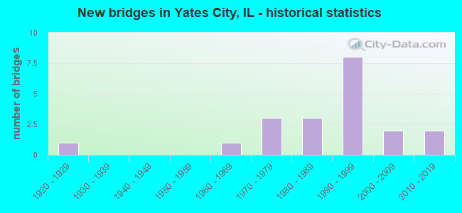
- New bridges - historical statistics
- 11920-1929
- 11960-1969
- 31970-1979
- 31980-1989
- 81990-1999
- 22000-2009
- 22010-2019


- Bridge Condition - Deck
- 61.1%Very good
- 16.7%Good
- 16.7%Satisfactory
- 5.6%Fair

- Bridge Condition - Superstructure
- 61.1%Very good
- 16.7%Good
- 16.7%Satisfactory
- 5.6%Fair

- Bridge Condition - Substructure
- 61.1%Very good
- 11.1%Good
- 16.7%Satisfactory
- 5.6%Poor
- 5.6%Serious

- Bridge Condition - Channel
- 5.3%Excellent
- 36.8%Very good
- 26.3%Good
- 15.8%Satisfactory
- 10.5%Fair
- 5.3%Poor
Find on map >> Show street view
Structure Number: 482002, Location: 4.5 MI E OF ILL 97 (Lat: 40.779147, Lng: -90.064108), Route carried "on" structure: State highway 8, Year Built: 1971, Status: Open, Structure Length: 0.76m (2.49ft), Average Daily Traffic: 850 (year 2021), Truck Traffic: 14%, Average Future Daily Traffic: 852 (year 2032), Design Load: HS 20, Features Intersected: STREAM
Minimum Vertical Clearance: 30+ m (98+ ft), Kilometerpoint: 7.274, Lanes on structure: 2, Owner: State Highway Agency, Approaching Roadway Width: 8.2m (26.9ft), Material/Design: Concrete continuous, Design/Construction: Culvert, Number Of Spans In Main Unit: 2, Length of Maximum Span: 3.4m (11.2ft)
Condition: Channel: Poor, Culverts: Fair, Operating Rating: 85.5 metric tons, Method Used To Determine Operating Rating: Allowable Stress (AS) rating reported by rating factor (RF) method using MS18 loading, Inventory Rating: 51.5 metric tons, Method Used To Determine Inventory Rating: Allowable Stress (AS) rating reported by rating factor (RF) method using MS18 loading, Structural Evaluation: Somewhat better than minimum adequacy, Waterway Adequacy: Equal to present minimum criteria, Approach Roadway Alignment: Equal to present desirable criteria, Designated Inspection Frequency: Every 24 months, Inspection Date: December 2019
Find on map >> Show street view
Structure Number: 483171, Location: W.CTR-33-T10NR4E (Lat: 40.808753, Lng: -90.062219), Route carried "on" structure: County highway , Year Built: 1969, Status: Open, Structure Length: 3.66m (12.01ft), Average Daily Traffic: 50 (year 2017), Average Future Daily Traffic: 50 (year 2032), Design Load: HS 15, Features Intersected: FRENCH CREEK, Facility Carried by Structure: TR 284A
Minimum Vertical Clearance: 30+ m (98+ ft), Kilometerpoint: 7.274, Lanes on structure: 2, Owner: Town or Township Highway Agency, Approaching Roadway Width: 8.5m (27.9ft), Skew: 3 degrees, Material/Design: Prestressed concrete, Design/Construction: Box Beam or Girders - Multiple, Number Of Spans In Main Unit: 3, Length of Maximum Span: 17.7m (58.1ft), Curb-To-Curb Width: 6.1m (20.0ft), Out-to-Out Width: 6.7m (22.0ft)
Condition: Deck: Satisfactory, Superstructure: Satisfactory, Substructure: Satisfactory, Channel: Fair, Operating Rating: 33.0 metric tons, Method Used To Determine Operating Rating: Load Factor (LF) rating reported by rating factor (RF) method using MS18 loading, Inventory Rating: 18.5 metric tons, Method Used To Determine Inventory Rating: Load Factor (LF) rating reported by rating factor (RF) method using MS18 loading, Structural Evaluation: Somewhat better than minimum adequacy, Deck Geometry: Somewhat better than minimum adequacy, Waterway Adequacy: Equal to present minimum criteria, Approach Roadway Alignment: Better than present minimum criteria, Designated Inspection Frequency: Every 24 months, Inspection Date: Febuary 2021, Deck Structure Type: Concrete Precast Panels, Wearing Surface/Protective System: Wearing Surface: Bituminous
Find on map >> Show street view
Structure Number: 483205, Location: SW-25-T10NR4E (Lat: 40.814711, Lng: -89.997267), Route carried "on" structure: County highway , Year Built: 1971, Status: Open, Structure Length: 1.08m (3.54ft), Average Daily Traffic: 10 (year 2017), Average Future Daily Traffic: 10 (year 2032), Design Load: HS 15, Features Intersected: SWAB RUN CREEK, Facility Carried by Structure: TR 291
Minimum Vertical Clearance: 30+ m (98+ ft), Kilometerpoint: 0.628, Lanes on structure: 2, Owner: Town or Township Highway Agency, Approaching Roadway Width: 6.7m (22.0ft), Material/Design: Prestressed concrete, Design/Construction: Box Beam or Girders - Multiple, Number Of Spans In Main Unit: 1, Length of Maximum Span: 10.1m (33.1ft), Curb-To-Curb Width: 6.1m (20.0ft), Out-to-Out Width: 7.1m (23.3ft)
Condition: Deck: Satisfactory, Superstructure: Satisfactory, Substructure: Poor, Channel: Satisfactory, Operating Rating: 36.3 metric tons, Method Used To Determine Operating Rating: Load Factor (LF) rating reported by rating factor (RF) method using MS18 loading, Inventory Rating: 21.7 metric tons, Method Used To Determine Inventory Rating: Load Factor (LF) rating reported by rating factor (RF) method using MS18 loading, Structural Evaluation: Meets minimum limits, Deck Geometry: Somewhat better than minimum adequacy, Waterway Adequacy: Better than present minimum criteria, Approach Roadway Alignment: Better than present minimum criteria, Designated Inspection Frequency: Every 24 months, Other Special Inspection Frequency: Every 6 months, Inspection Date: January 2021, Other Special Inspection Date: August 2021, Deck Structure Type: Concrete Precast Panels
Find on map >> Show street view
Structure Number: 483211, Location: SE-14-T9NR4E (Lat: 40.756325, Lng: -90.009797), Route carried "on" structure: County highway , Year Built: 1974, Status: Open, Structure Length: 1.10m (3.61ft), Average Daily Traffic: 50 (year 2017), Truck Traffic: 20%, Average Future Daily Traffic: 50 (year 2032), Design Load: HS 15, Features Intersected: KICKAPOO CREEK, Facility Carried by Structure: TR 341
Minimum Vertical Clearance: 30+ m (98+ ft), Kilometerpoint: 24.188, Lanes on structure: 2, Owner: Town or Township Highway Agency, Approaching Roadway Width: 6.1m (20.0ft), Material/Design: Prestressed concrete, Design/Construction: Box Beam or Girders - Multiple, Number Of Spans In Main Unit: 1, Length of Maximum Span: 10.1m (33.1ft), Curb-To-Curb Width: 7.9m (25.9ft), Out-to-Out Width: 8.6m (28.2ft)
Condition: Deck: Satisfactory, Superstructure: Satisfactory, Substructure: Serious, Channel: Satisfactory, Operating Rating: 35.0 metric tons, Method Used To Determine Operating Rating: Allowable Stress (AS) rating reported by rating factor (RF) method using MS18 loading, Inventory Rating: 21.7 metric tons, Method Used To Determine Inventory Rating: Allowable Stress (AS) rating reported by rating factor (RF) method using MS18 loading, Structural Evaluation: High priority of corrective action, Deck Geometry: Equal to present minimum criteria, Waterway Adequacy: Equal to present minimum criteria, Approach Roadway Alignment: Better than present minimum criteria, Designated Inspection Frequency: Every 24 months, Inspection Date: January 2022, Deck Structure Type: Concrete Precast Panels
Find on map >> Show street view
Structure Number: 483225, Location: SE-28-T10NR4E (Lat: 40.814983, Lng: -90.050758), Route carried "on" structure: County highway , Year Built: 1980, Status: Open, Structure Length: 1.52m (4.99ft), Average Daily Traffic: 25 (year 2017), Average Future Daily Traffic: 25 (year 2032), Design Load: HS 20, Features Intersected: TRIB TO FRENCH CREEK, Facility Carried by Structure: TR 289
Minimum Vertical Clearance: 30+ m (98+ ft), Kilometerpoint: 4.216, Lanes on structure: 2, Owner: Town or Township Highway Agency, Approaching Roadway Width: 7.3m (24.0ft), Material/Design: Prestressed concrete, Design/Construction: Box Beam or Girders - Multiple, Number Of Spans In Main Unit: 1, Length of Maximum Span: 14.9m (48.9ft), Curb-To-Curb Width: 7.2m (23.6ft), Out-to-Out Width: 7.4m (24.3ft)
Condition: Deck: Good, Superstructure: Good, Substructure: Very good, Channel: Satisfactory, Operating Rating: 44.4 metric tons, Method Used To Determine Operating Rating: Assigned rating based on Load Factor Design (LFD) reported by rating factor (RF) using MS18 loading, Inventory Rating: 32.4 metric tons, Method Used To Determine Inventory Rating: Assigned rating based on Load Factor Design (LFD) reported by rating factor (RF) using MS18 loading, Structural Evaluation: Better than present minimum criteria, Deck Geometry: Somewhat better than minimum adequacy, Waterway Adequacy: Better than present minimum criteria, Approach Roadway Alignment: Equal to present minimum criteria, Designated Inspection Frequency: Every 48 months, Inspection Date: Febuary 2021, Deck Structure Type: Concrete Precast Panels
Find on map >> Show street view
Structure Number: 483315, Location: W.CTR-32-T10NR4E (Lat: 40.809239, Lng: -90.081308), Route carried "on" structure: County highway , Year Built: 1988, Status: Open, Structure Length: 4.01m (13.16ft), Average Daily Traffic: 175 (year 2017), Truck Traffic: 11%, Average Future Daily Traffic: 125 (year 2032), Design Load: HS 20, Features Intersected: FRENCH CREEK, Facility Carried by Structure: CH 19
Minimum Vertical Clearance: 30+ m (98+ ft), Kilometerpoint: 2.317, Lanes on structure: 2, Owner: County Highway Agency, Approaching Roadway Width: 6.4m (21.0ft), Material/Design: Prestressed concrete, Design/Construction: Box Beam or Girders - Multiple, Number Of Spans In Main Unit: 3, Length of Maximum Span: 15.2m (49.9ft), Curb-To-Curb Width: 8.5m (27.9ft), Out-to-Out Width: 8.5m (27.9ft)
Condition: Deck: Good, Superstructure: Good, Substructure: Good, Channel: Fair, Operating Rating: 44.4 metric tons, Method Used To Determine Operating Rating: Assigned rating based on Load Factor Design (LFD) reported by rating factor (RF) using MS18 loading, Inventory Rating: 32.4 metric tons, Method Used To Determine Inventory Rating: Assigned rating based on Load Factor Design (LFD) reported by rating factor (RF) using MS18 loading, Structural Evaluation: Better than present minimum criteria, Deck Geometry: Equal to present minimum criteria, Waterway Adequacy: Equal to present desirable criteria, Approach Roadway Alignment: Equal to present desirable criteria, Designated Inspection Frequency: Every 48 months, Inspection Date: January 2022, Deck Structure Type: Concrete Precast Panels, Wearing Surface/Protective System: Wearing Surface: Bituminous, Membrane: Built-up
Find on map >> Show street view
Structure Number: 483317, Location: NW-5-T9NR4E (Lat: 40.793819, Lng: -90.075689), Route carried "on" structure: County highway , Year Built: 1988, Status: Open, Structure Length: 1.26m (4.13ft), Average Daily Traffic: 125 (year 2017), Truck Traffic: 8%, Average Future Daily Traffic: 100 (year 2032), Design Load: HS 20, Features Intersected: TRIB TO FRENCH CREEK, Facility Carried by Structure: TR 305
Minimum Vertical Clearance: 30+ m (98+ ft), Kilometerpoint: 2.124, Lanes on structure: 2, Owner: Town or Township Highway Agency, Approaching Roadway Width: 7.3m (24.0ft), Material/Design: Prestressed concrete, Design/Construction: Box Beam or Girders - Multiple, Number Of Spans In Main Unit: 1, Length of Maximum Span: 11.9m (39.0ft), Curb-To-Curb Width: 7.4m (24.3ft), Out-to-Out Width: 7.4m (24.3ft)
Condition: Deck: Very good, Superstructure: Very good, Substructure: Very good, Channel: Good, Operating Rating: 44.4 metric tons, Method Used To Determine Operating Rating: Assigned rating based on Load Factor Design (LFD) reported by rating factor (RF) using MS18 loading, Inventory Rating: 32.4 metric tons, Method Used To Determine Inventory Rating: Assigned rating based on Load Factor Design (LFD) reported by rating factor (RF) using MS18 loading, Structural Evaluation: Equal to present desirable criteria, Deck Geometry: Somewhat better than minimum adequacy, Waterway Adequacy: Equal to present desirable criteria, Approach Roadway Alignment: Better than present minimum criteria, Designated Inspection Frequency: Every 48 months, Inspection Date: January 2020, Deck Structure Type: Concrete Precast Panels
Find on map >> Show street view
Structure Number: 483333, Location: NW-27-T10NR4E (Lat: 40.825181, Lng: -90.035386), Route carried "on" structure: County highway , Year Built: 1990, Status: Open, Structure Length: 3.40m (11.15ft), Average Daily Traffic: 275 (year 2017), Truck Traffic: 4%, Average Future Daily Traffic: 200 (year 2032), Design Load: HS 20, Features Intersected: FRENCH CREEK, Facility Carried by Structure: FAS 396-CH 18
Minimum Vertical Clearance: 30+ m (98+ ft), Kilometerpoint: 2.591, Lanes on structure: 2, Owner: County Highway Agency, Approaching Roadway Width: 6.1m (20.0ft), Skew: 1 degrees, Material/Design: Prestressed concrete, Design/Construction: Box Beam or Girders - Multiple, Number Of Spans In Main Unit: 3, Length of Maximum Span: 15.2m (49.9ft), Curb-To-Curb Width: 8.5m (27.9ft), Out-to-Out Width: 8.5m (27.9ft)
Condition: Deck: Good, Superstructure: Good, Substructure: Satisfactory, Channel: Good, Operating Rating: 44.4 metric tons, Method Used To Determine Operating Rating: Assigned rating based on Load Factor Design (LFD) reported by rating factor (RF) using MS18 loading, Inventory Rating: 32.4 metric tons, Method Used To Determine Inventory Rating: Assigned rating based on Load Factor Design (LFD) reported by rating factor (RF) using MS18 loading, Structural Evaluation: Equal to present minimum criteria, Deck Geometry: Equal to present minimum criteria, Waterway Adequacy: Equal to present desirable criteria, Approach Roadway Alignment: Equal to present desirable criteria, Designated Inspection Frequency: Every 24 months, Inspection Date: Febuary 2021, Deck Structure Type: Concrete Precast Panels, Wearing Surface/Protective System: Wearing Surface: Bituminous, Membrane: Built-up
Find on map >> Show street view
Structure Number: 483334, Location: SW-32-T10NR4E (Lat: 40.803981, Lng: -90.081378), Route carried "on" structure: County highway , Year Built: 1992, Status: Open, Structure Length: 1.57m (5.15ft), Average Daily Traffic: 175 (year 2017), Truck Traffic: 11%, Average Future Daily Traffic: 125 (year 2032), Design Load: HS 20, Features Intersected: TRIB. FRENCH CREEK, Facility Carried by Structure: CH 19
Minimum Vertical Clearance: 30+ m (98+ ft), Kilometerpoint: 2.897, Lanes on structure: 2, Owner: County Highway Agency, Approaching Roadway Width: 8.5m (27.9ft), Material/Design: Prestressed concrete, Design/Construction: Box Beam or Girders - Multiple, Number Of Spans In Main Unit: 1, Length of Maximum Span: 14.9m (48.9ft), Curb-To-Curb Width: 8.5m (27.9ft), Out-to-Out Width: 8.5m (27.9ft)
Condition: Deck: Very good, Superstructure: Very good, Substructure: Very good, Channel: Very good, Operating Rating: 44.1 metric tons, Method Used To Determine Operating Rating: Assigned rating based on Load Factor Design (LFD) reported by rating factor (RF) using MS18 loading, Inventory Rating: 32.4 metric tons, Method Used To Determine Inventory Rating: Assigned rating based on Load Factor Design (LFD) reported by rating factor (RF) using MS18 loading, Structural Evaluation: Equal to present desirable criteria, Deck Geometry: Equal to present minimum criteria, Waterway Adequacy: Equal to present desirable criteria, Approach Roadway Alignment: Better than present minimum criteria, Designated Inspection Frequency: Every 48 months, Inspection Date: January 2022, Deck Structure Type: Concrete Precast Panels, Wearing Surface/Protective System: Wearing Surface: Bituminous, Membrane: Built-up
Find on map >> Show street view
Structure Number: 483336, Location: SW-36-T10NR4E (Lat: 40.804456, Lng: -90.004589), Route carried "on" structure: County highway , Year Built: 1992, Status: Open, Structure Length: 2.18m (7.15ft), Average Daily Traffic: 150 (year 2017), Truck Traffic: 7%, Average Future Daily Traffic: 100 (year 2032), Design Load: HS 20, Features Intersected: SWAB RUN CREEK, Facility Carried by Structure: TR 324
Minimum Vertical Clearance: 30+ m (98+ ft), Kilometerpoint: 5.874, Lanes on structure: 2, Owner: Town or Township Highway Agency, Approaching Roadway Width: 5.5m (18.0ft), Skew: 2 degrees, Material/Design: Prestressed concrete, Design/Construction: Box Beam or Girders - Multiple, Number Of Spans In Main Unit: 2, Length of Maximum Span: 12.0m (39.4ft), Curb-To-Curb Width: 7.3m (24.0ft), Out-to-Out Width: 7.3m (24.0ft)
Condition: Deck: Very good, Superstructure: Very good, Substructure: Very good, Channel: Good, Operating Rating: 44.1 metric tons, Method Used To Determine Operating Rating: Assigned rating based on Load Factor Design (LFD) reported by rating factor (RF) using MS18 loading, Inventory Rating: 32.4 metric tons, Method Used To Determine Inventory Rating: Assigned rating based on Load Factor Design (LFD) reported by rating factor (RF) using MS18 loading, Structural Evaluation: Equal to present desirable criteria, Deck Geometry: Somewhat better than minimum adequacy, Waterway Adequacy: Better than present minimum criteria, Approach Roadway Alignment: Better than present minimum criteria, Designated Inspection Frequency: Every 48 months, Inspection Date: Febuary 2021, Deck Structure Type: Concrete Precast Panels, Wearing Surface/Protective System: Wearing Surface: Bituminous, Membrane: Built-up
Find on map >> Show street view
Structure Number: 483339, Location: SE-22-T10NR4E (Lat: 40.832997, Lng: -90.024961), Route carried "on" structure: County highway , Year Built: 1993, Status: Open, Structure Length: 1.87m (6.14ft), Average Daily Traffic: 50 (year 2017), Average Future Daily Traffic: 50 (year 2032), Design Load: HS 20, Features Intersected: FRENCH CREEK, Facility Carried by Structure: TR 267
Minimum Vertical Clearance: 30+ m (98+ ft), Kilometerpoint: 1.529, Lanes on structure: 2, Owner: Town or Township Highway Agency, Approaching Roadway Width: 5.5m (18.0ft), Skew: 1 degrees, Material/Design: Prestressed concrete, Design/Construction: Box Beam or Girders - Multiple, Number Of Spans In Main Unit: 1, Length of Maximum Span: 18.0m (59.1ft), Curb-To-Curb Width: 7.3m (24.0ft), Out-to-Out Width: 7.3m (24.0ft)
Condition: Deck: Very good, Superstructure: Very good, Substructure: Very good, Channel: Good, Operating Rating: 44.1 metric tons, Method Used To Determine Operating Rating: Assigned rating based on Load Factor Design (LFD) reported by rating factor (RF) using MS18 loading, Inventory Rating: 32.4 metric tons, Method Used To Determine Inventory Rating: Assigned rating based on Load Factor Design (LFD) reported by rating factor (RF) using MS18 loading, Structural Evaluation: Equal to present desirable criteria, Deck Geometry: Equal to present minimum criteria, Waterway Adequacy: Equal to present desirable criteria, Approach Roadway Alignment: Equal to present minimum criteria, Designated Inspection Frequency: Every 48 months, Inspection Date: Febuary 2022, Deck Structure Type: Concrete Precast Panels
Find on map >> Show street view
Structure Number: 483346, Location: SW-35-T10NR4E (Lat: 40.801528, Lng: -90.023839), Route carried "on" structure: County highway , Year Built: 1996, Status: Open, Structure Length: 3.32m (10.89ft), Average Daily Traffic: 300 (year 2017), Truck Traffic: 10%, Average Future Daily Traffic: 276 (year 2032), Design Load: HS 20, Features Intersected: SWAB RUN CREEK, Facility Carried by Structure: FAS 396
Minimum Vertical Clearance: 30+ m (98+ ft), Kilometerpoint: 5.890, Lanes on structure: 2, Owner: County Highway Agency, Approaching Roadway Width: 8.5m (27.9ft), Material/Design: Prestressed concrete, Design/Construction: Box Beam or Girders - Multiple, Number Of Spans In Main Unit: 3, Length of Maximum Span: 9.1m (29.9ft), Curb-To-Curb Width: 8.5m (27.9ft), Out-to-Out Width: 8.5m (27.9ft)
Condition: Deck: Fair, Superstructure: Fair, Substructure: Satisfactory, Channel: Very good, Operating Rating: 44.1 metric tons, Method Used To Determine Operating Rating: Assigned rating based on Load Factor Design (LFD) reported by rating factor (RF) using MS18 loading, Inventory Rating: 32.4 metric tons, Method Used To Determine Inventory Rating: Assigned rating based on Load Factor Design (LFD) reported by rating factor (RF) using MS18 loading, Structural Evaluation: Somewhat better than minimum adequacy, Deck Geometry: Equal to present minimum criteria, Waterway Adequacy: Equal to present desirable criteria, Approach Roadway Alignment: Better than present minimum criteria, Designated Inspection Frequency: Every 24 months, Inspection Date: January 2022, Deck Structure Type: Concrete Precast Panels, Wearing Surface/Protective System: Wearing Surface: Bituminous, Membrane: Built-up
Find on map >> Show street view
Structure Number: 483352, Location: SW-32-T10NR4E (Lat: 40.801356, Lng: -90.081569), Route carried "on" structure: County highway , Year Built: 1997, Status: Open, Structure Length: 1.57m (5.15ft), Average Daily Traffic: 175 (year 2017), Truck Traffic: 11%, Average Future Daily Traffic: 125 (year 2032), Design Load: HS 20, Features Intersected: TRIB TO FRENCH CREEK, Facility Carried by Structure: COUNTY HIGHWAY 19
Minimum Vertical Clearance: 30+ m (98+ ft), Kilometerpoint: 3.186, Lanes on structure: 2, Owner: County Highway Agency, Approaching Roadway Width: 8.5m (27.9ft), Material/Design: Prestressed concrete, Design/Construction: Box Beam or Girders - Multiple, Number Of Spans In Main Unit: 1, Length of Maximum Span: 15.2m (49.9ft), Curb-To-Curb Width: 8.5m (27.9ft), Out-to-Out Width: 8.5m (27.9ft)
Condition: Deck: Very good, Superstructure: Very good, Substructure: Very good, Channel: Very good, Operating Rating: 44.1 metric tons, Method Used To Determine Operating Rating: Assigned rating based on Load Factor Design (LFD) reported by rating factor (RF) using MS18 loading, Inventory Rating: 32.4 metric tons, Method Used To Determine Inventory Rating: Assigned rating based on Load Factor Design (LFD) reported by rating factor (RF) using MS18 loading, Structural Evaluation: Equal to present desirable criteria, Deck Geometry: Equal to present minimum criteria, Waterway Adequacy: Superior to present desirable criteria, Approach Roadway Alignment: Equal to present desirable criteria, Designated Inspection Frequency: Every 48 months, Inspection Date: January 2022, Deck Structure Type: Concrete Precast Panels, Wearing Surface/Protective System: Wearing Surface: Bituminous, Membrane: Built-up
Find on map >> Show street view
Structure Number: 483353, Location: NW-5-T9NR4E (Lat: 40.799750, Lng: -90.081619), Route carried "on" structure: County highway , Year Built: 1997, Status: Open, Structure Length: 1.57m (5.15ft), Average Daily Traffic: 175 (year 2017), Truck Traffic: 11%, Average Future Daily Traffic: 125 (year 2032), Design Load: HS 20, Features Intersected: TRIB TO FRENCH CREEK, Facility Carried by Structure: CH 19
Minimum Vertical Clearance: 30+ m (98+ ft), Kilometerpoint: 3.363, Lanes on structure: 2, Owner: County Highway Agency, Approaching Roadway Width: 5.5m (18.0ft), Material/Design: Prestressed concrete, Design/Construction: Box Beam or Girders - Multiple, Number Of Spans In Main Unit: 1, Length of Maximum Span: 15.2m (49.9ft), Curb-To-Curb Width: 8.5m (27.9ft), Out-to-Out Width: 8.5m (27.9ft)
Condition: Deck: Very good, Superstructure: Very good, Substructure: Very good, Channel: Very good, Operating Rating: 44.1 metric tons, Method Used To Determine Operating Rating: Assigned rating based on Load Factor Design (LFD) reported by rating factor (RF) using MS18 loading, Inventory Rating: 32.4 metric tons, Method Used To Determine Inventory Rating: Assigned rating based on Load Factor Design (LFD) reported by rating factor (RF) using MS18 loading, Structural Evaluation: Equal to present desirable criteria, Deck Geometry: Equal to present minimum criteria, Waterway Adequacy: Superior to present desirable criteria, Approach Roadway Alignment: Equal to present desirable criteria, Designated Inspection Frequency: Every 48 months, Inspection Date: January 2022, Deck Structure Type: Concrete Precast Panels, Wearing Surface/Protective System: Wearing Surface: Bituminous, Membrane: Built-up
Find on map >> Show street view
Structure Number: 483368, Location: S.CTR-29-T10NR4E (Lat: 40.815108, Lng: -90.072353), Route carried "on" structure: County highway , Year Built: 2000, Status: Open, Structure Length: 1.55m (5.09ft), Average Daily Traffic: 25 (year 2017), Average Future Daily Traffic: 25 (year 2032), Design Load: HS 20, Features Intersected: TRIB TO FRENCH CREEK, Facility Carried by Structure: TR 289
Minimum Vertical Clearance: 30+ m (98+ ft), Kilometerpoint: 2.382, Lanes on structure: 2, Owner: Town or Township Highway Agency, Approaching Roadway Width: 5.5m (18.0ft), Material/Design: Prestressed concrete, Design/Construction: Box Beam or Girders - Multiple, Number Of Spans In Main Unit: 1, Length of Maximum Span: 14.9m (48.9ft), Curb-To-Curb Width: 7.3m (24.0ft), Out-to-Out Width: 7.3m (24.0ft)
Condition: Deck: Very good, Superstructure: Very good, Substructure: Very good, Channel: Very good, Operating Rating: 44.1 metric tons, Method Used To Determine Operating Rating: Assigned rating based on Load Factor Design (LFD) reported by rating factor (RF) using MS18 loading, Inventory Rating: 32.4 metric tons, Method Used To Determine Inventory Rating: Assigned rating based on Load Factor Design (LFD) reported by rating factor (RF) using MS18 loading, Structural Evaluation: Equal to present desirable criteria, Deck Geometry: Equal to present minimum criteria, Waterway Adequacy: Equal to present desirable criteria, Approach Roadway Alignment: Equal to present desirable criteria, Designated Inspection Frequency: Every 48 months, Inspection Date: January 2022, Deck Structure Type: Concrete Precast Panels, Wearing Surface/Protective System: Wearing Surface: Bituminous, Membrane: Built-up
Find on map >> Show street view
Structure Number: 483369, Location: SW-13-T9NR4E (Lat: 40.758186, Lng: -90.005042), Route carried "on" structure: County highway , Year Built: 1999, Status: Open, Structure Length: 1.87m (6.14ft), Average Daily Traffic: 700 (year 2017), Truck Traffic: 3%, Average Future Daily Traffic: 651 (year 2032), Design Load: HS 20, Features Intersected: KICKAPOO CREEK, Facility Carried by Structure: TR 324B
Minimum Vertical Clearance: 30+ m (98+ ft), Kilometerpoint: 1.416, Lanes on structure: 2, Owner: Town or Township Highway Agency, Approaching Roadway Width: 5.5m (18.0ft), Material/Design: Prestressed concrete, Design/Construction: Box Beam or Girders - Multiple, Number Of Spans In Main Unit: 1, Length of Maximum Span: 18.0m (59.1ft), Curb-To-Curb Width: 7.3m (24.0ft), Out-to-Out Width: 7.3m (24.0ft)
Condition: Deck: Very good, Superstructure: Very good, Substructure: Very good, Channel: Very good, Operating Rating: 44.1 metric tons, Method Used To Determine Operating Rating: Assigned rating based on Load Factor Design (LFD) reported by rating factor (RF) using MS18 loading, Inventory Rating: 32.4 metric tons, Method Used To Determine Inventory Rating: Assigned rating based on Load Factor Design (LFD) reported by rating factor (RF) using MS18 loading, Structural Evaluation: Equal to present desirable criteria, Deck Geometry: Meets minimum limits, Waterway Adequacy: Equal to present desirable criteria, Approach Roadway Alignment: Equal to present desirable criteria, Designated Inspection Frequency: Every 48 months, Inspection Date: January 2021, Deck Structure Type: Concrete Precast Panels, Wearing Surface/Protective System: Wearing Surface: Bituminous, Membrane: Built-up
Find on map >> Show street view
Structure Number: 483376, Location: SW-24-T9NR4E (Lat: 40.745375, Lng: -90.005061), Route carried "on" structure: County highway , Year Built: 2002, Status: Open, Structure Length: 2.34m (7.68ft), Average Daily Traffic: 700 (year 2017), Truck Traffic: 3%, Average Future Daily Traffic: 651 (year 2032), Design Load: HS 20, Features Intersected: KICKAPOO CREEK, Facility Carried by Structure: TR 324 B
Minimum Vertical Clearance: 30+ m (98+ ft), Kilometerpoint: 2.848, Lanes on structure: 2, Owner: Town or Township Highway Agency, Approaching Roadway Width: 7.3m (24.0ft), Skew: 2 degrees, Material/Design: Prestressed concrete, Design/Construction: Box Beam or Girders - Multiple, Number Of Spans In Main Unit: 1, Length of Maximum Span: 22.2m (72.8ft), Curb-To-Curb Width: 7.3m (24.0ft), Out-to-Out Width: 7.3m (24.0ft)
Condition: Deck: Very good, Superstructure: Very good, Substructure: Very good, Channel: Very good, Operating Rating: 44.1 metric tons, Method Used To Determine Operating Rating: Assigned rating based on Load Factor Design (LFD) reported by rating factor (RF) using MS18 loading, Inventory Rating: 32.4 metric tons, Method Used To Determine Inventory Rating: Assigned rating based on Load Factor Design (LFD) reported by rating factor (RF) using MS18 loading, Structural Evaluation: Equal to present desirable criteria, Deck Geometry: Meets minimum limits, Waterway Adequacy: Superior to present desirable criteria, Approach Roadway Alignment: Equal to present desirable criteria, Designated Inspection Frequency: Every 48 months, Inspection Date: January 2021, Deck Structure Type: Concrete Precast Panels, Wearing Surface/Protective System: Wearing Surface: Bituminous, Membrane: Built-up
Find on map >> Show street view
Structure Number: 483401, Location: 1.3 Mi N. of Ill. 8 (Lat: 40.799722, Lng: -90.033531), Route carried "on" structure: County highway , Year Built: 2015, Status: Open, Structure Length: 2.35m (7.71ft), Average Daily Traffic: 25 (year 2017), Average Future Daily Traffic: 25 (year 2038), Design Load: HS 25 or greater, Features Intersected: SWAB RUB CREEK, Facility Carried by Structure: TR 304
Minimum Vertical Clearance: 30+ m (98+ ft), Kilometerpoint: 3.203, Lanes on structure: 2, Owner: Town or Township Highway Agency, Approaching Roadway Width: 6.1m (20.0ft), Material/Design: Prestressed concrete, Design/Construction: Box Beam or Girders - Multiple, Number Of Spans In Main Unit: 1, Length of Maximum Span: 22.6m (74.1ft), Curb-To-Curb Width: 7.3m (24.0ft), Out-to-Out Width: 7.3m (24.0ft)
Condition: Deck: Very good, Superstructure: Very good, Substructure: Very good, Channel: Excellent, Operating Rating: 42.1 metric tons, Method Used To Determine Operating Rating: Assigned ratings based on Load and Resistance Factor Design (LRFD) reported by rating factor (RF) using HL93 loadings, Inventory Rating: 32.4 metric tons, Method Used To Determine Inventory Rating: Assigned ratings based on Load and Resistance Factor Design (LRFD) reported by rating factor (RF) using HL93 loadings, Structural Evaluation: Equal to present desirable criteria, Deck Geometry: Equal to present minimum criteria, Waterway Adequacy: Better than present minimum criteria, Approach Roadway Alignment: Equal to present desirable criteria, Designated Inspection Frequency: Every 48 months, Inspection Date: January 2021, Deck Structure Type: Concrete Precast Panels, Wearing Surface/Protective System: Deck Protection: Epoxy Coated Reinforcing
Find on map >> Show street view
Structure Number: 483408, Location: SW-34-T10NR4E (Lat: 40.805144, Lng: -90.037006), Route carried "on" structure: County highway , Year Built: 2019, Status: Open, Structure Length: 3.05m (10.01ft), Average Daily Traffic: 25 (year 2017), Average Future Daily Traffic: 25 (year 2039), Design Load: HS 25 or greater, Features Intersected: FRENCH CREEK, Facility Carried by Structure: TR 304
Minimum Vertical Clearance: 30+ m (98+ ft), Kilometerpoint: 2.478, Lanes on structure: 2, Owner: Town or Township Highway Agency, Approaching Roadway Width: 5.5m (18.0ft), Skew: 2 degrees, Material/Design: Prestressed concrete, Design/Construction: Box Beam or Girders - Multiple, Number Of Spans In Main Unit: 3, Length of Maximum Span: 12.2m (40.0ft), Curb-To-Curb Width: 7.3m (24.0ft), Out-to-Out Width: 8.5m (27.9ft)
Condition: Deck: Very good, Superstructure: Very good, Substructure: Good, Channel: Good, Operating Rating: 70.6 metric tons, Method Used To Determine Operating Rating: Load and Resistance Factor Rating (LRFR) rating reported by rating factor(RF) method using HL-93 loadings, Inventory Rating: 54.4 metric tons, Method Used To Determine Inventory Rating: Load and Resistance Factor Rating (LRFR) rating reported by rating factor(RF) method using HL-93 loadings, Structural Evaluation: Better than present minimum criteria, Deck Geometry: Equal to present minimum criteria, Waterway Adequacy: Equal to present minimum criteria, Approach Roadway Alignment: Equal to present minimum criteria, Designated Inspection Frequency: Every 24 months, Inspection Date: January 2022, Deck Structure Type: Concrete Precast Panels, Wearing Surface/Protective System: Deck Protection: Epoxy Coated Reinforcing
Find on map >> Show street view
Structure Number: 489901, Location: CTR-10-T9NR4E (Lat: 40.780169, Lng: -90.036419), Route carried "under" structure: State highway 8, Year Built: 1927, Structure Length: 0. m, Average Daily Traffic: 850 (year 2021), Truck Traffic: 14%, Features Intersected: ILL 8, Facility Carried by Structure: BN RR (072662X)
Minimum Vertical Clearance: 4.14m (13.58ft), Kilometerpoint: 9.656, Lanes under structure: 2, Material/Design: Steel, Design/Construction: Girder and Floorbeam System, Length of Maximum Span: 9.8m (32.2ft)