Bridge Statistics for Yale, Michigan (MI)
Condition, Traffic, Stress, Structural Evaluation, Project Costs
- National Bridge Inventory (NBI) Statistics
- 11Number of bridges
- 56ft / 16.9mTotal length
- $452,019,000Total costs
- 3,642Total average daily traffic
- 217Total average daily truck traffic
- 5,424Total future (year 2014) average daily traffic
- National Bridge Inventory (NBI) Registered Bridges for Yale
- No street view available for this location
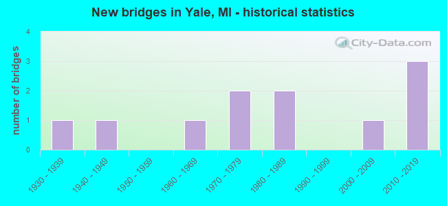
- New bridges - historical statistics
- 11930-1939
- 11940-1949
- 11960-1969
- 21970-1979
- 21980-1989
- 12000-2009
- 32010-2019

- Reconstructed bridges - Historical Statistics
- 11990-1999
- 02000-2009
- 12010-2019


- Bridge Condition - Deck
- 14.3%Excellent
- 28.6%Very good
- 28.6%Good
- 14.3%Satisfactory
- 14.3%Fair

- Bridge Condition - Superstructure
- 14.3%Very good
- 42.9%Good
- 28.6%Satisfactory
- 14.3%Poor

- Bridge Condition - Substructure
- 14.3%Excellent
- 14.3%Very good
- 42.9%Good
- 14.3%Satisfactory
- 14.3%Fair

- Bridge Condition - Channel
- 18.2%Very good
- 63.6%Good
- 18.2%Satisfactory

- Bridge Condition - Culverts
- 25.0%Very good
- 50.0%Satisfactory
- 25.0%Fair
Find on map >> Show street view
Structure Number: 1026, Location: 3.5 MI E OF STEVENSVILLE (Lat: 42.017561, Lng: -86.446100), Route carried "on" structure: County highway , Year Built: 1960, Year Reconstructed: 1999, Status: Open, Structure Length: 0.97m (3.18ft), Average Daily Traffic: 343 (year 2007), Truck Traffic: 3%, Average Future Daily Traffic: 600 (year 2027), Design Load: HS 20, Features Intersected: YELLOW CREEK, Facility Carried by Structure: YELLOW CREEK DRIVE
Minimum Vertical Clearance: 30.48m (100.00ft), Kilometerpoint: 8.605, Lanes on structure: 2, Owner: County Highway Agency, Approaching Roadway Width: 9.1m (29.9ft), Material/Design: Wood or Timber, Design/Construction: Slab, Number Of Spans In Main Unit: 1, Length of Maximum Span: 9.4m (30.8ft), Curb-To-Curb Width: 7.9m (25.9ft), Out-to-Out Width: 8.0m (26.2ft)
Condition: Deck: Good, Superstructure: Good, Substructure: Satisfactory, Channel: Good, Operating Rating: 56.7 metric tons, Method Used To Determine Operating Rating: Allowable Stress (AS) rating reported by rating factor (RF) method using MS18 loading, Inventory Rating: 39.5 metric tons, Method Used To Determine Inventory Rating: Allowable Stress (AS) rating reported by rating factor (RF) method using MS18 loading, Structural Evaluation: Equal to present minimum criteria, Deck Geometry: Somewhat better than minimum adequacy, Waterway Adequacy: Better than present minimum criteria, Approach Roadway Alignment: Equal to present minimum criteria, Designated Inspection Frequency: Every 24 months, Inspection Date: July 2020, Deck Structure Type: Wood or Timber, Wearing Surface/Protective System: Wearing Surface: Bituminous
Find on map >> Show street view
Structure Number: 9546, Location: SEC 31-32 FREMONT TWP (Lat: 43.163064, Lng: -82.742058), Route carried "on" structure: County highway , Year Built: 1976, Status: Open, Structure Length: 0.62m (2.03ft), Average Daily Traffic: 540 (year 2010), Truck Traffic: 10%, Average Future Daily Traffic: 975 (year 2030), Design Load: H 20, Features Intersected: JACKSON CREEK I/C DRAIN, Facility Carried by Structure: BRICKER ROAD
Minimum Vertical Clearance: 30.48m (100.00ft), Kilometerpoint: 0.220, Lanes on structure: 2, Owner: County Highway Agency, Approaching Roadway Width: 9.1m (29.9ft), Material/Design: Steel, Design/Construction: Culvert, Number Of Spans In Main Unit: 1, Length of Maximum Span: 6.2m (20.3ft), Curb-To-Curb Width: 8.9m (29.2ft), Out-to-Out Width: 18.3m (60.0ft)
Condition: Channel: Good, Culverts: Satisfactory, Operating Rating: 97.2 metric tons, Method Used To Determine Operating Rating: Load Factor (LF) rating reported by rating factor (RF) method using MS18 loading, Inventory Rating: 85.9 metric tons, Method Used To Determine Inventory Rating: Load Factor (LF) rating reported by rating factor (RF) method using MS18 loading, Structural Evaluation: Equal to present minimum criteria, Deck Geometry: Somewhat better than minimum adequacy, Waterway Adequacy: Equal to present minimum criteria, Approach Roadway Alignment: Equal to present desirable criteria, Designated Inspection Frequency: Every 24 months, Inspection Date: June 2020
Find on map >> Show street view
Structure Number: 9622, Location: SEC 31 FREMONT TWP (Lat: 43.160764, Lng: -82.752167), Route carried "on" structure: County highway , Year Built: 2016, Status: Open, Structure Length: 0.80m (2.62ft), Average Daily Traffic: 200 (year 2010), Truck Traffic: 10%, Average Future Daily Traffic: 360 (year 2030), Design Load: Greater than HL93, Features Intersected: JACKSON CREEK I/C DRAIN, Facility Carried by Structure: FISHER ROAD
Minimum Vertical Clearance: 30.48m (100.00ft), Kilometerpoint: 7.228, Lanes on structure: 2, Owner: County Highway Agency, Approaching Roadway Width: 9.1m (29.9ft), Skew: 1 degrees, Material/Design: Concrete, Design/Construction: Culvert, Number Of Spans In Main Unit: 1, Length of Maximum Span: 7.4m (24.3ft), Curb-To-Curb Width: 9.4m (30.8ft), Out-to-Out Width: 13.6m (44.6ft)
Condition: Channel: Good, Culverts: Satisfactory, Operating Rating: 51.2 metric tons, Method Used To Determine Operating Rating: Load and Resistance Factor Rating (LRFR) rating reported by rating factor(RF) method using HL-93 loadings, Inventory Rating: 39.5 metric tons, Method Used To Determine Inventory Rating: Load and Resistance Factor Rating (LRFR) rating reported by rating factor(RF) method using HL-93 loadings, Structural Evaluation: Equal to present minimum criteria, Deck Geometry: Equal to present minimum criteria, Waterway Adequacy: Equal to present minimum criteria, Approach Roadway Alignment: Better than present minimum criteria, Designated Inspection Frequency: Every 24 months, Inspection Date: June 2020, Deck Structure Type: Concrete Precast Panels, Wearing Surface/Protective System: Wearing Surface: Gravel
Find on map >> Show street view
Structure Number: 10086, Location: SEC. 27 BROCKWAY TWP. (Lat: 43.094125, Lng: -82.805992), Route carried "on" structure: County highway , Year Built: 1979, Status: Open, Structure Length: 0.61m (2.00ft), Average Daily Traffic: 160 (year 1994), Truck Traffic: 2%, Average Future Daily Traffic: 170 (year 2014), Design Load: HS 20+Mod, Features Intersected: SHEEHY DRAIN, Facility Carried by Structure: CONNELL ROAD
Minimum Vertical Clearance: 30.48m (100.00ft), Kilometerpoint: 4.038, Lanes on structure: 2, Owner: County Highway Agency, Approaching Roadway Width: 7.3m (24.0ft), Material/Design: Steel, Design/Construction: Culvert, Number Of Spans In Main Unit: 2, Length of Maximum Span: 3.3m (10.8ft), Curb-To-Curb Width: 8.5m (27.9ft), Out-to-Out Width: 9.7m (31.8ft)
Condition: Channel: Good, Culverts: Fair, Operating Rating: 92.3 metric tons, Method Used To Determine Operating Rating: Load Factor (LF) rating reported by rating factor (RF) method using MS18 loading, Inventory Rating: 71.3 metric tons, Method Used To Determine Inventory Rating: Load Factor (LF) rating reported by rating factor (RF) method using MS18 loading, Structural Evaluation: Somewhat better than minimum adequacy, Deck Geometry: Equal to present minimum criteria, Waterway Adequacy: Equal to present desirable criteria, Approach Roadway Alignment: Equal to present desirable criteria, Designated Inspection Frequency: Every 24 months, Inspection Date: December 2020, Wearing Surface/Protective System: Wearing Surface: Gravel
Find on map >> Show street view
Structure Number: 10087, Location: SEC. 16-17 GREENWOOD TWP. (Lat: 43.132400, Lng: -82.719958), Route carried "on" structure: County highway , Year Built: 2013, Status: Open, Structure Length: 0.67m (2.20ft), Average Daily Traffic: 150 (year 2013), Truck Traffic: 17%, Average Future Daily Traffic: 225 (year 2033), Design Load: HS 20+Mod, Features Intersected: EVES DRAIN, Facility Carried by Structure: BROWN ROAD
Minimum Vertical Clearance: 30.48m (100.00ft), Kilometerpoint: 12.824, Lanes on structure: 2, Owner: County Highway Agency, Approaching Roadway Width: 7.3m (24.0ft), Material/Design: Steel, Design/Construction: Culvert, Number Of Spans In Main Unit: 2, Length of Maximum Span: 3.5m (11.5ft), Curb-To-Curb Width: 10.4m (34.1ft), Out-to-Out Width: 20.7m (67.9ft)
Condition: Channel: Very good, Culverts: Very good, Operating Rating: 40.5 metric tons, Method Used To Determine Operating Rating: Load and Resistance Factor Rating (LRFR) rating reported by rating factor(RF) method using HL-93 loadings, Inventory Rating: 33.4 metric tons, Method Used To Determine Inventory Rating: Load and Resistance Factor Rating (LRFR) rating reported by rating factor(RF) method using HL-93 loadings, Structural Evaluation: Equal to present desirable criteria, Deck Geometry: Better than present minimum criteria, Waterway Adequacy: Better than present minimum criteria, Approach Roadway Alignment: Equal to present minimum criteria, Designated Inspection Frequency: Every 24 months, Inspection Date: December 2021, Wearing Surface/Protective System: Wearing Surface: Bituminous
Find on map >> Show street view
Structure Number: 10119, Location: SEC.23-26 BROCKWAY TWP. (Lat: 43.101147, Lng: -82.795558), Route carried "on" structure: ServiceCounty highway , Year Built: 1980, Status: Posted for load, Structure Length: 1.89m (6.20ft), Average Daily Traffic: 120 (year 1994), Truck Traffic: 3%, Average Future Daily Traffic: 130 (year 2014), Design Load: HS 20+Mod, Features Intersected: MILL CREEK, Facility Carried by Structure: WILKES ROAD
Minimum Vertical Clearance: 30.48m (100.00ft), Kilometerpoint: 2.361, Lanes on structure: 2, Owner: County Highway Agency, Approaching Roadway Width: 6.1m (20.0ft), Material/Design: Prestressed concrete, Design/Construction: Box Beam or Girders - Multiple, Number Of Spans In Main Unit: 1, Length of Maximum Span: 17.6m (57.7ft), Curb-To-Curb Width: 9.1m (29.9ft), Out-to-Out Width: 9.6m (31.5ft)
Condition: Deck: Fair, Superstructure: Poor, Substructure: Good, Channel: Good, Operating Rating: 58.0 metric tons, Method Used To Determine Operating Rating: Load Factor (LF) rating reported by rating factor (RF) method using MS18 loading, Inventory Rating: 34.7 metric tons, Method Used To Determine Inventory Rating: Load Factor (LF) rating reported by rating factor (RF) method using MS18 loading, Structural Evaluation: Meets minimum limits, Deck Geometry: Equal to present minimum criteria, Waterway Adequacy: Equal to present desirable criteria, Approach Roadway Alignment: Equal to present minimum criteria, Bridge Posting: Required (Relationship of Operating Rating to Maximum Legal Load: 0.1 - 9.9% below), Length Of Structure Improvement: 2.29m (7.51ft), Designated Inspection Frequency: Every 12 months, Inspection Date: January 2022, Roadway Improvement Cost: $6,000, Total Project Cost: $7,000, Deck Structure Type: Concrete Cast-file-Place, Wearing Surface/Protective System: Wearing Surface: Bituminous
Find on map >> Show street view
Structure Number: 1012, Location: SEC. 4-9 BROCKWAY TWP. (Lat: 43.143528, Lng: -82.836642), Route carried "on" structure: ServiceCounty highway , Year Built: 1939, Status: Posted for load, Structure Length: 2.26m (7.41ft), Average Daily Traffic: 426 (year 2019), Truck Traffic: 4%, Average Future Daily Traffic: 630 (year 2039), Design Load: H 20, Features Intersected: S. BR. MILL CREEK DRAIN, Facility Carried by Structure: JEDDO ROAD
Minimum Vertical Clearance: 30.48m (100.00ft), Kilometerpoint: 11.238, Lanes on structure: 2, Owner: County Highway Agency, Approaching Roadway Width: 12.2m (40.0ft), Material/Design: Steel, Design/Construction: Stringer/Multi-beam, Number Of Spans In Main Unit: 2, Length of Maximum Span: 10.8m (35.4ft), Curb-To-Curb Width: 6.1m (20.0ft), Out-to-Out Width: 7.0m (23.0ft)
Condition: Deck: Satisfactory, Superstructure: Good, Substructure: Fair, Channel: Satisfactory, Operating Rating: 53.8 metric tons, Method Used To Determine Operating Rating: Load Factor (LF) rating reported by rating factor (RF) method using MS18 loading, Inventory Rating: 32.1 metric tons, Method Used To Determine Inventory Rating: Load Factor (LF) rating reported by rating factor (RF) method using MS18 loading, Structural Evaluation: Somewhat better than minimum adequacy, Deck Geometry: High priority of corrective action, Waterway Adequacy: Somewhat better than minimum adequacy, Approach Roadway Alignment: Better than present minimum criteria, Bridge Posting: Required (Relationship of Operating Rating to Maximum Legal Load: 0.1 - 9.9% below), Length Of Structure Improvement: 4.57m (14.99ft), Designated Inspection Frequency: Every 24 months, Inspection Date: January 2021, Roadway Improvement Cost: $10,000, Total Project Cost: $12,000, Deck Structure Type: Concrete Cast-file-Place, Wearing Surface/Protective System: Wearing Surface: Monolithic Concrete
Find on map >> Show street view
Structure Number: 10121, Location: SEC. 3-10 BROCKWAY TWP (Lat: 43.144039, Lng: -82.818361), Route carried "on" structure: ServiceCounty highway , Year Built: 1940, Year Reconstructed: 2018, Status: Open, Structure Length: 1.94m (6.36ft), Average Daily Traffic: 426 (year 2019), Truck Traffic: 10%, Average Future Daily Traffic: 630 (year 2039), Design Load: Greater than HL93, Features Intersected: MILL CREEK, Facility Carried by Structure: JEDDO ROAD
Minimum Vertical Clearance: 30.48m (100.00ft), Kilometerpoint: 12.726, Lanes on structure: 2, Owner: County Highway Agency, Approaching Roadway Width: 9.1m (29.9ft), Material/Design: Steel, Design/Construction: Stringer/Multi-beam, Number Of Spans In Main Unit: 1, Length of Maximum Span: 18.1m (59.4ft), Curb-To-Curb Width: 7.9m (25.9ft), Out-to-Out Width: 8.9m (29.2ft)
Condition: Deck: Excellent, Superstructure: Satisfactory, Substructure: Good, Channel: Good, Operating Rating: 46.7 metric tons, Method Used To Determine Operating Rating: Load and Resistance Factor Rating (LRFR) rating reported by rating factor(RF) method using HL-93 loadings, Inventory Rating: 36.0 metric tons, Method Used To Determine Inventory Rating: Load and Resistance Factor Rating (LRFR) rating reported by rating factor(RF) method using HL-93 loadings, Structural Evaluation: Equal to present minimum criteria, Deck Geometry: Somewhat better than minimum adequacy, Waterway Adequacy: Equal to present minimum criteria, Approach Roadway Alignment: Better than present minimum criteria, Length Of Structure Improvement: 6.25m (20.51ft), Designated Inspection Frequency: Every 24 months, Inspection Date: July 2020, Bridge Improvement Cost: $305,000,000, Roadway Improvement Cost: $147,000,000, Total Project Cost: $452,000,000 ( Estimate for 2016), Deck Structure Type: Concrete Precast Panels, Wearing Surface/Protective System: Wearing Surface: Epoxy Overlay, Deck Protection: Epoxy Coated Reinforcing
Find on map >> Show street view
Structure Number: 10122, Location: SEC. 8-9 BROCKWAY TWP. (Lat: 43.141867, Lng: -82.838683), Route carried "on" structure: ServiceCounty highway , Year Built: 2000, Status: Open, Structure Length: 2.55m (8.37ft), Average Daily Traffic: 200 (year 1999), Truck Traffic: 6%, Average Future Daily Traffic: 440 (year 2019), Design Load: HS 20, Features Intersected: S. BR. MILL CREEK DRAIN, Facility Carried by Structure: ARENDT ROAD
Minimum Vertical Clearance: 30.48m (100.00ft), Kilometerpoint: 4.677, Lanes on structure: 2, Owner: County Highway Agency, Approaching Roadway Width: 9.6m (31.5ft), Skew: 2 degrees, Material/Design: Prestressed concrete, Design/Construction: Box Beam or Girders - Single/Spread, Number Of Spans In Main Unit: 1, Length of Maximum Span: 25.0m (82.0ft), Curb-To-Curb Width: 9.6m (31.5ft), Out-to-Out Width: 10.0m (32.8ft)
Condition: Deck: Very good, Superstructure: Satisfactory, Substructure: Very good, Channel: Good, Operating Rating: 55.7 metric tons, Method Used To Determine Operating Rating: Load and Resistance Factor Rating (LRFR) rating reported by rating factor(RF) method using HL-93 loadings, Inventory Rating: 43.1 metric tons, Method Used To Determine Inventory Rating: Load and Resistance Factor Rating (LRFR) rating reported by rating factor(RF) method using HL-93 loadings, Structural Evaluation: Equal to present minimum criteria, Deck Geometry: Equal to present minimum criteria, Waterway Adequacy: Equal to present minimum criteria, Approach Roadway Alignment: Equal to present desirable criteria, Designated Inspection Frequency: Every 24 months, Inspection Date: January 2021, Deck Structure Type: Concrete Cast-file-Place, Wearing Surface/Protective System: Wearing Surface: Monolithic Concrete, Deck Protection: Epoxy Coated Reinforcing
Find on map >> Show street view
Structure Number: 10123, Location: SEC. 3-4 BROCKWAY TWP. (Lat: 43.148378, Lng: -82.819422), Route carried "on" structure: ServiceCounty highway , Year Built: 1985, Status: Open, Structure Length: 2.71m (8.89ft), Average Daily Traffic: 190 (year 1994), Truck Traffic: 3%, Average Future Daily Traffic: 200 (year 2014), Design Load: HS 20+Mod, Features Intersected: MILL CREEK, Facility Carried by Structure: JORDEN ROAD
Minimum Vertical Clearance: 30.48m (100.00ft), Kilometerpoint: 8.560, Lanes on structure: 2, Owner: County Highway Agency, Approaching Roadway Width: 5.4m (17.7ft), Material/Design: Prestressed concrete, Design/Construction: Tee Beam, Number Of Spans In Main Unit: 3, Length of Maximum Span: 9.1m (29.9ft), Curb-To-Curb Width: 9.1m (29.9ft), Out-to-Out Width: 9.8m (32.2ft)
Condition: Deck: Good, Superstructure: Good, Substructure: Good, Channel: Satisfactory, Operating Rating: 79.1 metric tons, Method Used To Determine Operating Rating: Load Factor (LF) rating reported by rating factor (RF) method using MS18 loading, Inventory Rating: 47.3 metric tons, Method Used To Determine Inventory Rating: Load Factor (LF) rating reported by rating factor (RF) method using MS18 loading, Structural Evaluation: Better than present minimum criteria, Deck Geometry: Equal to present minimum criteria, Waterway Adequacy: High priority of corrective action, Approach Roadway Alignment: Equal to present desirable criteria, Designated Inspection Frequency: Every 24 months, Inspection Date: December 2020, Deck Structure Type: Concrete Cast-file-Place, Wearing Surface/Protective System: Wearing Surface: Bituminous, Membrane: Preformed Fabric, Deck Protection: Epoxy Coated Reinforcing
Find on map >> Show street view
Structure Number: 1026, Location: CITY OF YALE (Lat: 43.124911, Lng: -82.798292), Route carried "on" structure: Business City street , Year Built: 2012, Status: Open, Structure Length: 1.89m (6.20ft), Average Daily Traffic: 887 (year 2011), Truck Traffic: 3%, Average Future Daily Traffic: 1,064 (year 2031), Design Load: Greater than HL93, Features Intersected: MILL CREEK, Facility Carried by Structure: SOUTH MAIN STREET
Minimum Vertical Clearance: 30.48m (100.00ft), Kilometerpoint: 1.067, Lanes on structure: 2, Owner: City or Municipal Highway Agency, Approaching Roadway Width: 7.9m (25.9ft), Skew: 2 degrees, Material/Design: Prestressed concrete, Design/Construction: Box Beam or Girders - Multiple, Number Of Spans In Main Unit: 1, Length of Maximum Span: 18.3m (60.0ft), Curb or Sidewalk Widths: Left: 1.5m (4.9ft), Right: 0.0m, Curb-To-Curb Width: 8.3m (27.2ft), Out-to-Out Width: 10.6m (34.8ft)
Condition: Deck: Very good, Superstructure: Very good, Substructure: Excellent, Channel: Very good, Operating Rating: 60.4 metric tons, Method Used To Determine Operating Rating: Load and Resistance Factor (LRFR), Inventory Rating: 35.7 metric tons, Method Used To Determine Inventory Rating: Load and Resistance Factor (LRFR), Structural Evaluation: Equal to present desirable criteria, Deck Geometry: Somewhat better than minimum adequacy, Waterway Adequacy: Equal to present desirable criteria, Approach Roadway Alignment: Equal to present minimum criteria, Designated Inspection Frequency: Every 24 months, Inspection Date: September 2021, Deck Structure Type: Concrete Cast-file-Place, Wearing Surface/Protective System: Wearing Surface: Monolithic Concrete, Deck Protection: Epoxy Coated Reinforcing