Bridge Statistics for Wyano, Pennsylvania (PA)
Condition, Traffic, Stress, Structural Evaluation, Project Costs
- National Bridge Inventory (NBI) Statistics
- 10Number of bridges
- 43ft / 13.5mTotal length
- $484,000Total costs
- 81,231Total average daily traffic
- 28,097Total average daily truck traffic
- National Bridge Inventory (NBI) Registered Bridges for Wyano
- No street view available for this location
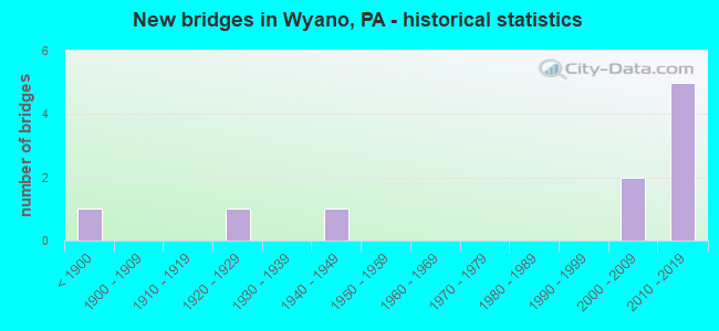
- New bridges - historical statistics
- 1Before 1900
- 11920-1929
- 11940-1949
- 22000-2009
- 52010-2019

- Reconstructed bridges - Historical Statistics
- 11980-1989
- 01990-1999
- 12000-2009


- Bridge Condition - Deck
- 33.3%Very good
- 16.7%Good
- 50.0%Fair

- Bridge Condition - Superstructure
- 33.3%Very good
- 16.7%Good
- 16.7%Satisfactory
- 33.3%Fair

- Bridge Condition - Substructure
- 33.3%Very good
- 16.7%Good
- 16.7%Satisfactory
- 16.7%Fair
- 16.7%Poor

- Bridge Condition - Channel
- 60.0%Satisfactory
- 40.0%Poor
Find on map >> Show street view
Structure Number: 36297, Location: SOUTH HUNINGDON TOWNSHIP (Lat: 40.153731, Lng: -79.691444), Route carried "on" structure: State highway 981, Year Built: 1928, Year Reconstructed: 2007, Status: Open, Structure Length: 0.73m (2.40ft), Average Daily Traffic: 1,470 (year 2021), Truck Traffic: 6%, Average Future Daily Traffic: 1,722 (year 2032), Design Load: HS 25 or greater, Features Intersected: BRANCH OF BARRON RUN
Minimum Vertical Clearance: 30+ m (98+ ft), Kilometerpoint: 8.262, Lanes on structure: 2, Owner: State Highway Agency, Approaching Roadway Width: 6.7m (22.0ft), Skew: 3 degrees, Material/Design: Concrete, Design/Construction: Tee Beam, Number Of Spans In Main Unit: 1, Length of Maximum Span: 6.7m (22.0ft), Curb-To-Curb Width: 7.4m (24.3ft), Out-to-Out Width: 7.8m (25.6ft)
Condition: Deck: Fair, Superstructure: Fair, Substructure: Fair, Channel: Poor, Operating Rating: 63.5 metric tons, Method Used To Determine Operating Rating: Allowable Stress (AS), Inventory Rating: 41.7 metric tons, Method Used To Determine Inventory Rating: Allowable Stress (AS), Structural Evaluation: Somewhat better than minimum adequacy, Deck Geometry: Meets minimum limits, Waterway Adequacy: Superior to present desirable criteria, Approach Roadway Alignment: Better than present minimum criteria, Length Of Structure Improvement: 0.70m (2.30ft), Designated Inspection Frequency: Every 24 months, Inspection Date: July 2021, Bridge Improvement Cost: $19,000, Roadway Improvement Cost: $150,000, Total Project Cost: $258,000, Deck Structure Type: Concrete Cast-file-Place, Wearing Surface/Protective System: Wearing Surface: Bituminous
Find on map >> Show street view
Structure Number: 36606, Location: SOUTH HUNTINGDON TOWNSHIP (Lat: 40.155289, Lng: -79.695931), Route carried "on" structure: State highway , Year Built: 1941, Status: Posted for load, Structure Length: 0.67m (2.20ft), Average Daily Traffic: 521 (year 2022), Truck Traffic: 9%, Average Future Daily Traffic: 706 (year 2032), Design Load: HS 20, Features Intersected: BARREN RUN, Facility Carried by Structure: SR 3035
Minimum Vertical Clearance: 30+ m (98+ ft), Kilometerpoint: 2.169, Lanes on structure: 2, Owner: State Highway Agency, Approaching Roadway Width: 7.0m (23.0ft), Skew: 4 degrees, Material/Design: Concrete, Design/Construction: Slab, Number Of Spans In Main Unit: 1, Length of Maximum Span: 6.1m (20.0ft), Curb or Sidewalk Widths: Left: 0.3m (1.0ft), Right: 0.3m (1.0ft), Curb-To-Curb Width: 7.0m (23.0ft), Out-to-Out Width: 8.2m (26.9ft)
Condition: Deck: Fair, Superstructure: Fair, Substructure: Poor, Channel: Poor, Operating Rating: 35.4 metric tons, Method Used To Determine Operating Rating: Allowable Stress (AS), Inventory Rating: 22.7 metric tons, Method Used To Determine Inventory Rating: Allowable Stress (AS), Structural Evaluation: Meets minimum limits, Deck Geometry: Meets minimum limits, Waterway Adequacy: Superior to present desirable criteria, Approach Roadway Alignment: Equal to present desirable criteria, Bridge Posting: Required (Relationship of Operating Rating to Maximum Legal Load: 0.1 - 9.9% below), Length Of Structure Improvement: 1.20m (3.94ft), Designated Inspection Frequency: Every 24 months, Other Special Inspection Frequency: Every 12 months, Inspection Date: January 2020, Other Special Inspection Date: December 2020, Bridge Improvement Cost: $17,000, Roadway Improvement Cost: $49,000, Total Project Cost: $226,000, Wearing Surface/Protective System: Wearing Surface: Bituminous
Find on map >> Show street view
Structure Number: 36964, Location: 1/2 MI EAST OF SR 136 (Lat: 40.219308, Lng: -79.710064), Route carried "on" structure: City street 3061, Year Built: 1850, Year Reconstructed: 1988, Status: Posted for load, Structure Length: 3.02m (9.91ft), Average Daily Traffic: 1,100 (year 2012), Average Future Daily Traffic: 1,400 (year 2032), Design Load: HS 25 or greater, Features Intersected: SEWICKLEY CREEK, Facility Carried by Structure: BELLS MILL ROAD
Minimum Vertical Clearance: 3.68m (12.07ft), Kilometerpoint: 0.000, Lanes on structure: 1, Base Highway Network: Yes, Owner: County Highway Agency, Approaching Roadway Width: 6.7m (22.0ft), Material/Design: Wood or Timber, Design/Construction: Truss - Thru, Number Of Spans In Main Unit: 1, Length of Maximum Span: 28.3m (92.8ft), Curb or Sidewalk Widths: Left: 0.2m (0.7ft), Right: 0.2m (0.7ft), Curb-To-Curb Width: 3.4m (11.2ft), Out-to-Out Width: 4.7m (15.4ft)
Condition: Deck: Fair, Superstructure: Satisfactory, Substructure: Satisfactory, Channel: Satisfactory, Operating Rating: 10.0 metric tons, Method Used To Determine Operating Rating: Allowable Stress (AS), Inventory Rating: 7.3 metric tons, Method Used To Determine Inventory Rating: Allowable Stress (AS), Structural Evaluation: High priority of corrective action, Deck Geometry: High priority of replacement, Waterway Adequacy: Superior to present desirable criteria, Approach Roadway Alignment: Meets minimum limits, Bridge Posting: Required (Relationship of Operating Rating to Maximum Legal Load: > 39.9% below), Length Of Structure Improvement: 4.10m (13.45ft), Designated Inspection Frequency: Every 24 months, Other Special Inspection Frequency: Every 12 months, Inspection Date: June 2020, Other Special Inspection Date: June 2021, Deck Structure Type: Wood or Timber
Find on map >> Show street view
Structure Number: 40992, Location: SOUTH HUNTINGDON TWP (Lat: 40.193681, Lng: -79.663536), Route carried "on" structure: State highway , Year Built: 2000, Status: Open, Structure Length: 0.67m (2.20ft), Average Daily Traffic: 843 (year 2020), Truck Traffic: 7%, Average Future Daily Traffic: 1,112 (year 2032), Design Load: HS 25 or greater, Features Intersected: BR SEWICKLEY CK, Facility Carried by Structure: SR3037
Minimum Vertical Clearance: 30+ m (98+ ft), Kilometerpoint: 7.084, Lanes on structure: 2, Owner: State Highway Agency, Approaching Roadway Width: 8.8m (28.9ft), Skew: 3 degrees, Material/Design: Concrete, Design/Construction: Culvert, Number Of Spans In Main Unit: 2, Length of Maximum Span: 3.0m (9.8ft), Curb-To-Curb Width: 8.8m (28.9ft), Out-to-Out Width: 10.0m (32.8ft)
Condition: Channel: Satisfactory, Culverts: Good, Operating Rating: 49.0 metric tons, Method Used To Determine Operating Rating: Field evaluation and documented engineering judgment, Inventory Rating: 32.7 metric tons, Method Used To Determine Inventory Rating: Field evaluation and documented engineering judgment, Structural Evaluation: Better than present minimum criteria, Deck Geometry: Somewhat better than minimum adequacy, Waterway Adequacy: Equal to present minimum criteria, Approach Roadway Alignment: Equal to present desirable criteria, Length Of Structure Improvement: 1.30m (4.27ft), Designated Inspection Frequency: Every 48 months, Inspection Date: January 2020
Find on map >> Show street view
Structure Number: 41632, Location: SOUTH HUNTINGTON TWP. (Lat: 40.153356, Lng: -79.697539), Route carried "on" structure: State highway 981, Year Built: 2002, Status: Open, Structure Length: 1.07m (3.51ft), Average Daily Traffic: 1,470 (year 2021), Truck Traffic: 6%, Average Future Daily Traffic: 1,722 (year 2032), Design Load: HS 25 or greater, Features Intersected: BARREN RUN
Minimum Vertical Clearance: 30+ m (98+ ft), Kilometerpoint: 7.432, Lanes on structure: 2, Owner: State Highway Agency, Approaching Roadway Width: 10.7m (35.1ft), Material/Design: Prestressed concrete, Design/Construction: Box Beam or Girders - Multiple, Number Of Spans In Main Unit: 1, Length of Maximum Span: 10.1m (33.1ft), Curb or Sidewalk Widths: Left: 0.1m (0.3ft), Right: 0.1m (0.3ft), Curb-To-Curb Width: 10.2m (33.5ft), Out-to-Out Width: 10.2m (33.5ft)
Condition: Deck: Good, Superstructure: Very good, Substructure: Good, Channel: Satisfactory, Inventory Rating: 78.0 metric tons, Method Used To Determine Inventory Rating: Load Factor (LF), Structural Evaluation: Better than present minimum criteria, Deck Geometry: Somewhat better than minimum adequacy, Waterway Adequacy: Better than present minimum criteria, Approach Roadway Alignment: Equal to present minimum criteria, Length Of Structure Improvement: 1.80m (5.91ft), Designated Inspection Frequency: Every 48 months, Inspection Date: July 2019, Deck Structure Type: Concrete Cast-file-Place, Wearing Surface/Protective System: Wearing Surface: Monolithic Concrete, Deck Protection: Epoxy Coated Reinforcing
Find on map >> Show street view
Structure Number: 5673, Location: South Huntingdon Township (Lat: 40.183333, Lng: -79.710000), Route carried "on" structure: State highway , Year Built: 2019, Status: Open, Structure Length: 4.51m (14.80ft), Average Daily Traffic: 278 (year 2021), Truck Traffic: 7%, Average Future Daily Traffic: 2 (year 2041), Design Load: HL 93, Features Intersected: SR 0070, Facility Carried by Structure: SR 3040 / TR 318
Minimum Vertical Clearance: 30+ m (98+ ft), Kilometerpoint: 0.000, Lanes on structure: 2, Lanes under structure: 4, Owner: State Highway Agency, Approaching Roadway Width: 6.1m (20.0ft), Skew: 3 degrees, Material/Design: Prestressed concrete, Design/Construction: Stringer/Multi-beam, Number Of Spans In Main Unit: 1, Length of Maximum Span: 44.2m (145.0ft), Curb or Sidewalk Widths: Left: 0.1m (0.3ft), Right: 0.1m (0.3ft), Curb-To-Curb Width: 8.5m (27.9ft), Out-to-Out Width: 9.6m (31.5ft)
Condition: Deck: Very good, Superstructure: Very good, Substructure: Very good, Operating Rating: 60.6 metric tons, Method Used To Determine Operating Rating: Assigned ratings based on Load and Resistance Factor Design (LRFD) reported by rating factor (RF) using HL93 loadings, Inventory Rating: 45.7 metric tons, Method Used To Determine Inventory Rating: Assigned ratings based on Load and Resistance Factor Design (LRFD) reported by rating factor (RF) using HL93 loadings, Structural Evaluation: Equal to present desirable criteria, Deck Geometry: Equal to present minimum criteria, Underclear: Equal to present minimum criteria, Approach Roadway Alignment: Equal to present desirable criteria, Designated Inspection Frequency: Every 24 months, Inspection Date: May 2021, Deck Structure Type: Concrete Cast-file-Place, Wearing Surface/Protective System: Wearing Surface: Monolithic Concrete, Deck Protection: Epoxy Coated Reinforcing
Find on map >> Show street view
Structure Number: 57367, Location: SOUTH HUNTINGDON TOWNSHIP (Lat: 40.188578, Lng: -79.700956), Route carried "on" structure: Interstate 70, Year Built: 2019, Status: Open, Structure Length: 2.80m (9.19ft), Average Daily Traffic: 36,884 (year 2022), Truck Traffic: 40%, Average Future Daily Traffic: 40,600 (year 2036), Design Load: HL 93, Features Intersected: PA Route 31
Minimum Vertical Clearance: 30+ m (98+ ft), Kilometerpoint: 16.621, Lanes on structure: 2, Lanes under structure: 4, Base Highway Network: Yes, Owner: State Highway Agency, Approaching Roadway Width: 27.4m (89.9ft), Skew: 34 degrees, Material/Design: Prestressed concrete, Design/Construction: Box Beam or Girders - Single/Spread, Number Of Spans In Main Unit: 1, Length of Maximum Span: 28.0m (91.9ft), Curb or Sidewalk Widths: Left: 0.2m (0.7ft), Right: 0.2m (0.7ft), Curb-To-Curb Width: 27.4m (89.9ft), Out-to-Out Width: 29.5m (96.8ft)
Condition: Deck: Very good, Superstructure: Good, Substructure: Very good, Operating Rating: 57.3 metric tons, Method Used To Determine Operating Rating: Assigned ratings based on Load and Resistance Factor Design (LRFD) reported by rating factor (RF) using HL93 loadings, Inventory Rating: 40.2 metric tons, Method Used To Determine Inventory Rating: Assigned ratings based on Load and Resistance Factor Design (LRFD) reported by rating factor (RF) using HL93 loadings, Structural Evaluation: Better than present minimum criteria, Deck Geometry: Superior to present desirable criteria, Underclear: Equal to present minimum criteria, Approach Roadway Alignment: Equal to present desirable criteria, Designated Inspection Frequency: Every 24 months, Inspection Date: May 2021, Deck Structure Type: Concrete Cast-file-Place, Wearing Surface/Protective System: Wearing Surface: Monolithic Concrete, Deck Protection: Epoxy Coated Reinforcing
Find on map >> Show street view
Structure Number: 5673, Location: South Huntingdon Township (Lat: 40.183333, Lng: -79.710000), Route carried "under" structure: Interstate 70, Year Built: 2019, Structure Length: 0. m, Average Daily Traffic: 17,286 (year 2022), Truck Traffic: 38%, Features Intersected: SR 0070, Facility Carried by Structure: SR 3040 / TR 318
Minimum Vertical Clearance: 5.59m (18.34ft), Kilometerpoint: 15.818, Lanes on structure: 2, Lanes under structure: 2, Material/Design: Prestressed concrete, Design/Construction: Stringer/Multi-beam, Length of Maximum Span: 44.2m (145.0ft)
Find on map >> Show street view
Structure Number: 5673, Location: South Huntingdon Township (Lat: 40.183333, Lng: -79.710000), Route carried "under" structure: Interstate 70, Year Built: 2019, Structure Length: 0. m, Average Daily Traffic: 17,653 (year 2022), Truck Traffic: 35%, Features Intersected: SR 0070, Facility Carried by Structure: SR 3040 / TR 318
Minimum Vertical Clearance: 5.59m (18.34ft), Kilometerpoint: 15.825, Lanes on structure: 2, Lanes under structure: 2, Material/Design: Prestressed concrete, Design/Construction: Stringer/Multi-beam, Length of Maximum Span: 44.2m (145.0ft)
Find on map >> Show street view
Structure Number: 57367, Location: SOUTH HUNTINGDON TOWNSHIP (Lat: 40.188578, Lng: -79.700956), Route carried "under" structure: State highway 31, Year Built: 2019, Structure Length: 0. m, Average Daily Traffic: 3,726 (year 2022), Truck Traffic: 8%, Features Intersected: PA Route 31, Facility Carried by Structure: SR 0070
Minimum Vertical Clearance: 5.06m (16.60ft), Kilometerpoint: 4.445, Lanes on structure: 2, Lanes under structure: 4, Material/Design: Prestressed concrete, Design/Construction: Box Beam or Girders - Single/Spread, Length of Maximum Span: 28.0m (91.9ft)