Bridge Statistics for Wrightsville, Pennsylvania (PA)
Condition, Traffic, Stress, Structural Evaluation, Project Costs
- National Bridge Inventory (NBI) Statistics
- 10Number of bridges
- 92ft / 27.6mTotal length
- $2,863,000Total costs
- 112,787Total average daily traffic
- 17,307Total average daily truck traffic
- National Bridge Inventory (NBI) Registered Bridges for Wrightsville
- No street view available for this location
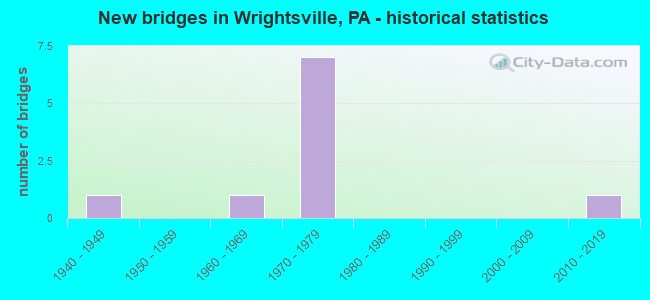
- New bridges - historical statistics
- 11940-1949
- 11960-1969
- 71970-1979
- 12010-2019


- Bridge Condition - Deck
- 50.0%Good
- 16.7%Satisfactory
- 16.7%Fair
- 16.7%Poor

- Bridge Condition - Superstructure
- 16.7%Very good
- 16.7%Good
- 50.0%Fair
- 16.7%Poor

- Bridge Condition - Substructure
- 16.7%Good
- 33.3%Satisfactory
- 50.0%Fair

- Bridge Condition - Channel
- 25.0%Satisfactory
- 75.0%Fair
Find on map >> Show street view
Structure Number: 37385, Location: 1 MI W OF WRIGHTSVILLE (Lat: 40.024711, Lng: -76.564042), Route carried "on" structure: State highway , Year Built: 1970, Year Reconstructed: 1994, Status: Open, Structure Length: 8.11m (26.61ft), Average Daily Traffic: 317 (year 2021), Truck Traffic: 11%, Average Future Daily Traffic: 460 (year 2032), Design Load: HS 20, Features Intersected: US 30; SR 0030, Facility Carried by Structure: T-776; BURGS LANE
Minimum Vertical Clearance: 30+ m (98+ ft), Kilometerpoint: 0.000, Lanes on structure: 2, Lanes under structure: 8, Owner: State Highway Agency, Approaching Roadway Width: 6.7m (22.0ft), Material/Design: Prestressed concrete, Design/Construction: Box Beam or Girders - Multiple, Number Of Spans In Main Unit: 2, Number Of Approach Spans: 2, Length of Maximum Span: 29.6m (97.1ft), Curb or Sidewalk Widths: Left: 0.2m (0.7ft), Right: 0.2m (0.7ft), Curb-To-Curb Width: 11.0m (36.1ft), Out-to-Out Width: 12.2m (40.0ft)
Condition: Deck: Satisfactory, Superstructure: Fair, Substructure: Satisfactory, Operating Rating: 47.2 metric tons, Method Used To Determine Operating Rating: Load Factor (LF), Inventory Rating: 28.1 metric tons, Method Used To Determine Inventory Rating: Load Factor (LF), Structural Evaluation: Somewhat better than minimum adequacy, Deck Geometry: Equal to present desirable criteria, Underclear: Somewhat better than minimum adequacy, Approach Roadway Alignment: Better than present minimum criteria, Length Of Structure Improvement: 9.10m (29.86ft), Designated Inspection Frequency: Every 24 months, Inspection Date: September 2021, Bridge Improvement Cost: $62,000, Roadway Improvement Cost: $182,000, Total Project Cost: $835,000, Deck Structure Type: Concrete Cast-file-Place, Wearing Surface/Protective System: Wearing Surface: Monolithic Concrete
Find on map >> Show street view
Structure Number: 37626, Location: SOUTH WRIGHTSVILLE (Lat: 40.019486, Lng: -76.523581), Route carried "on" structure: State highway 624, Year Built: 1941, Status: Open, Structure Length: 2.65m (8.69ft), Average Daily Traffic: 2,838 (year 2020), Truck Traffic: 8%, Average Future Daily Traffic: 3,265 (year 2032), Design Load: HS 20, Features Intersected: KREUTZ CREEK
Minimum Vertical Clearance: 30+ m (98+ ft), Kilometerpoint: 20.516, Lanes on structure: 2, Owner: State Highway Agency, Approaching Roadway Width: 7.9m (25.9ft), Material/Design: Concrete, Design/Construction: Tee Beam, Number Of Spans In Main Unit: 2, Length of Maximum Span: 12.2m (40.0ft), Curb or Sidewalk Widths: Left: 0.3m (1.0ft), Right: 1.6m (5.2ft), Curb-To-Curb Width: 7.4m (24.3ft), Out-to-Out Width: 9.7m (31.8ft)
Condition: Deck: Fair, Superstructure: Fair, Substructure: Fair, Channel: Satisfactory, Operating Rating: 55.3 metric tons, Method Used To Determine Operating Rating: Load Factor (LF), Inventory Rating: 32.7 metric tons, Method Used To Determine Inventory Rating: Load Factor (LF), Structural Evaluation: Somewhat better than minimum adequacy, Deck Geometry: High priority of replacement, Waterway Adequacy: Better than present minimum criteria, Approach Roadway Alignment: Better than present minimum criteria, Length Of Structure Improvement: 3.40m (11.15ft), Designated Inspection Frequency: Every 24 months, Inspection Date: August 2021, Bridge Improvement Cost: $38,000, Roadway Improvement Cost: $112,000, Total Project Cost: $513,000, Deck Structure Type: Concrete Cast-file-Place, Wearing Surface/Protective System: Wearing Surface: Bituminous, Membrane: Preformed Fabric
Find on map >> Show street view
Structure Number: 37671, Location: .7 MI N OF LR128 (Lat: 40.028092, Lng: -76.553161), Route carried "on" structure: State highway , Year Built: 1970, Status: Open, Structure Length: 7.65m (25.10ft), Average Daily Traffic: 9,974 (year 2022), Truck Traffic: 7%, Average Future Daily Traffic: 14,705 (year 2032), Design Load: HS 20, Features Intersected: 30 Lincoln Highway, Facility Carried by Structure: 1016 Cool Spring R
Minimum Vertical Clearance: 30+ m (98+ ft), Kilometerpoint: 1.978, Lanes on structure: 2, Lanes under structure: 8, Owner: State Highway Agency, Approaching Roadway Width: 13.4m (44.0ft), Skew: 1 degrees, Material/Design: Prestressed concrete, Design/Construction: Box Beam or Girders - Single/Spread, Number Of Spans In Main Unit: 4, Number Of Approach Spans: 2, Length of Maximum Span: 26.8m (87.9ft), Curb or Sidewalk Widths: Left: 0.2m (0.7ft), Right: 0.2m (0.7ft), Curb-To-Curb Width: 13.4m (44.0ft), Out-to-Out Width: 14.6m (47.9ft)
Condition: Deck: Good, Superstructure: Fair, Substructure: Satisfactory, Operating Rating: 64.4 metric tons, Method Used To Determine Operating Rating: Load Factor (LF), Inventory Rating: 26.3 metric tons, Method Used To Determine Inventory Rating: Load Factor (LF), Structural Evaluation: Somewhat better than minimum adequacy, Deck Geometry: Equal to present minimum criteria, Underclear: High priority of corrective action, Approach Roadway Alignment: Equal to present desirable criteria, Length Of Structure Improvement: 8.60m (28.22ft), Designated Inspection Frequency: Every 24 months, Inspection Date: November 2019, Bridge Improvement Cost: $94,000, Roadway Improvement Cost: $278,000, Total Project Cost: $1,274,000, Deck Structure Type: Concrete Cast-file-Place, Wearing Surface/Protective System: Wearing Surface: Monolithic Concrete
Find on map >> Show street view
Structure Number: 37702, Location: .5 MI S OF WRIGHTSVILLE (Lat: 40.015339, Lng: -76.539700), Route carried "on" structure: State highway , Year Built: 1970, Status: Open, Structure Length: 2.35m (7.71ft), Average Daily Traffic: 9,667 (year 2021), Truck Traffic: 7%, Average Future Daily Traffic: 10,398 (year 2032), Design Load: HS 20, Features Intersected: KREUTZ CREEK, Facility Carried by Structure: SR 2011
Minimum Vertical Clearance: 30+ m (98+ ft), Kilometerpoint: 4.257, Lanes on structure: 2, Owner: State Highway Agency, Approaching Roadway Width: 13.4m (44.0ft), Skew: 3 degrees, Material/Design: Prestressed concrete, Design/Construction: Box Beam or Girders - Single/Spread, Number Of Spans In Main Unit: 1, Length of Maximum Span: 22.9m (75.1ft), Curb or Sidewalk Widths: Left: 0.2m (0.7ft), Right: 0.2m (0.7ft), Curb-To-Curb Width: 13.4m (44.0ft), Out-to-Out Width: 14.6m (47.9ft)
Condition: Deck: Good, Superstructure: Good, Substructure: Fair, Channel: Fair, Operating Rating: 89.8 metric tons, Method Used To Determine Operating Rating: Load Factor (LF), Inventory Rating: 30.8 metric tons, Method Used To Determine Inventory Rating: Load Factor (LF), Structural Evaluation: Somewhat better than minimum adequacy, Deck Geometry: Equal to present minimum criteria, Waterway Adequacy: Equal to present minimum criteria, Approach Roadway Alignment: Equal to present desirable criteria, Length Of Structure Improvement: 3.00m (9.84ft), Designated Inspection Frequency: Every 24 months, Underwater Inspection Frequency: Every 24 months, Inspection Date: August 2021, Underwater Inspection Date: July 2020, Bridge Improvement Cost: $18,000, Roadway Improvement Cost: $52,000, Total Project Cost: $241,000, Deck Structure Type: Concrete Cast-file-Place, Wearing Surface/Protective System: Wearing Surface: Latex Concrete
Find on map >> Show street view
Structure Number: 38134, Location: 1.35SW WRGHTSVLE/KREUTZ C (Lat: 40.010597, Lng: -76.556247), Route carried "on" structure: City street , Year Built: 1961, Status: Posted for load, Structure Length: 3.66m (12.01ft), Average Daily Traffic: 631 (year 2011), Truck Traffic: 5%, Average Future Daily Traffic: 1,200 (year 2032), Design Load: HS 20, Features Intersected: KREUTZ CREEK, Facility Carried by Structure: STRICKLER SCHOOL R
Minimum Vertical Clearance: 30+ m (98+ ft), Kilometerpoint: 0.000, Lanes on structure: 2, Owner: County Highway Agency, Approaching Roadway Width: 6.1m (20.0ft), Material/Design: Prestressed concrete, Design/Construction: Box Beam or Girders - Multiple, Number Of Spans In Main Unit: 2, Length of Maximum Span: 17.7m (58.1ft), Curb-To-Curb Width: 5.9m (19.4ft), Out-to-Out Width: 6.4m (21.0ft)
Condition: Deck: Poor, Superstructure: Poor, Substructure: Fair, Channel: Fair, Operating Rating: 47.2 metric tons, Method Used To Determine Operating Rating: Load Factor (LF), Inventory Rating: 20.0 metric tons, Method Used To Determine Inventory Rating: Load Factor (LF), Structural Evaluation: Meets minimum limits, Deck Geometry: High priority of replacement, Waterway Adequacy: Better than present minimum criteria, Approach Roadway Alignment: Somewhat better than minimum adequacy, Length Of Structure Improvement: 4.60m (15.09ft), Designated Inspection Frequency: Every 24 months, Other Special Inspection Frequency: Every 6 months, Inspection Date: May 2021, Other Special Inspection Date: May 2021, Deck Structure Type: Concrete Cast-file-Place, Wearing Surface/Protective System: Wearing Surface: Monolithic Concrete
Find on map >> Show street view
Structure Number: 46655, Location: 1.4 Mi SW Wrightsville/Kr (Lat: 40.014139, Lng: -76.548100), Route carried "on" structure: City street 7212, Year Built: 2011, Status: Open, Structure Length: 3.20m (10.50ft), Average Daily Traffic: 128 (year 2010), Truck Traffic: 5%, Average Future Daily Traffic: 257 (year 2032), Design Load: HL 93, Features Intersected: Kreutz creek, Facility Carried by Structure: Bairs Mill Road
Minimum Vertical Clearance: 30+ m (98+ ft), Kilometerpoint: 0.000, Lanes on structure: 2, Owner: County Highway Agency, Approaching Roadway Width: 6.7m (22.0ft), Material/Design: Prestressed concrete continuous, Design/Construction: Box Beam or Girders - Single/Spread, Number Of Spans In Main Unit: 2, Length of Maximum Span: 15.5m (50.9ft), Curb or Sidewalk Widths: Left: 0.2m (0.7ft), Right: 0.2m (0.7ft), Curb-To-Curb Width: 6.7m (22.0ft), Out-to-Out Width: 7.7m (25.3ft)
Condition: Deck: Good, Superstructure: Very good, Substructure: Good, Channel: Fair, Operating Rating: 60.3 metric tons, Method Used To Determine Operating Rating: Assigned ratings based on Load and Resistance Factor Design (LRFD) reported by rating factor (RF) using HL93 loadings, Inventory Rating: 39.5 metric tons, Method Used To Determine Inventory Rating: Assigned ratings based on Load and Resistance Factor Design (LRFD) reported by rating factor (RF) using HL93 loadings, Structural Evaluation: Better than present minimum criteria, Deck Geometry: Meets minimum limits, Waterway Adequacy: Equal to present minimum criteria, Approach Roadway Alignment: Better than present minimum criteria, Designated Inspection Frequency: Every 24 months, Inspection Date: August 2021, Deck Structure Type: Concrete Cast-file-Place, Wearing Surface/Protective System: Wearing Surface: Monolithic Concrete, Deck Protection: Epoxy Coated Reinforcing
Find on map >> Show street view
Structure Number: 37385, Location: 1 MI W OF WRIGHTSVILLE (Lat: 40.024711, Lng: -76.564042), Route carried "under" structure: US 30, Year Built: 1970, Structure Length: 0. m, Average Daily Traffic: 21,964 (year 2020), Truck Traffic: 16%, Features Intersected: US 30; SR 0030, Facility Carried by Structure: T-776; BURGS LANE
Minimum Vertical Clearance: 4.42m (14.50ft), Kilometerpoint: 41.130, Lanes on structure: 2, Lanes under structure: 4, Material/Design: Prestressed concrete, Design/Construction: Box Beam or Girders - Multiple, Length of Maximum Span: 29.6m (97.1ft)
Find on map >> Show street view
Structure Number: 37385, Location: 1 MI W OF WRIGHTSVILLE (Lat: 40.024711, Lng: -76.564042), Route carried "under" structure: US 30, Year Built: 1970, Structure Length: 0. m, Average Daily Traffic: 21,270 (year 2020), Truck Traffic: 17%, Features Intersected: US 30; SR 0030, Facility Carried by Structure: T-776; BURGS LANE
Minimum Vertical Clearance: 4.72m (15.49ft), Kilometerpoint: 41.175, Lanes on structure: 2, Lanes under structure: 4, Material/Design: Prestressed concrete, Design/Construction: Box Beam or Girders - Multiple, Length of Maximum Span: 29.6m (97.1ft)
Find on map >> Show street view
Structure Number: 37671, Location: .7 MI N OF LR128 (Lat: 40.028092, Lng: -76.553161), Route carried "under" structure: US 30, Year Built: 1970, Structure Length: 0. m, Average Daily Traffic: 23,274 (year 2020), Truck Traffic: 18%, Features Intersected: 30 Lincoln Highway, Facility Carried by Structure: 1016 Cool Spring R
Minimum Vertical Clearance: 4.57m (14.99ft), Kilometerpoint: 42.137, Lanes on structure: 2, Lanes under structure: 4, Material/Design: Prestressed concrete, Design/Construction: Box Beam or Girders - Single/Spread, Length of Maximum Span: 26.8m (87.9ft)
Find on map >> Show street view
Structure Number: 37671, Location: .7 MI N OF LR128 (Lat: 40.028092, Lng: -76.553161), Route carried "under" structure: US 30, Year Built: 1970, Structure Length: 0. m, Average Daily Traffic: 22,724 (year 2020), Truck Traffic: 19%, Features Intersected: 30 Lincoln Highway, Facility Carried by Structure: 1016 Cool Spring R
Minimum Vertical Clearance: 4.47m (14.67ft), Kilometerpoint: 42.166, Lanes on structure: 2, Lanes under structure: 4, Material/Design: Prestressed concrete, Design/Construction: Box Beam or Girders - Single/Spread, Length of Maximum Span: 26.8m (87.9ft)