Bridge Statistics for Worden, Illinois (IL)
Condition, Traffic, Stress, Structural Evaluation, Project Costs
- National Bridge Inventory (NBI) Statistics
- 16Number of bridges
- 161ft / 49.5mTotal length
- $141,000Total costs
- 110,025Total average daily traffic
- 26,220Total average daily truck traffic
- National Bridge Inventory (NBI) Registered Bridges for Worden
- No street view available for this location
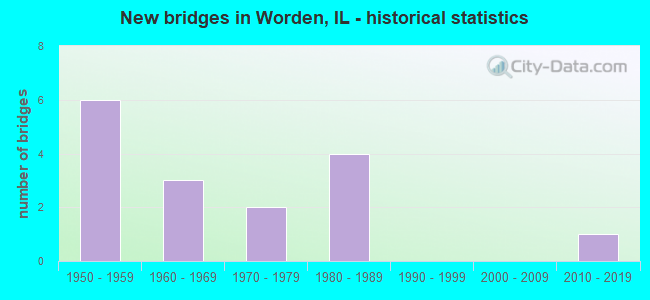
- New bridges - historical statistics
- 61950-1959
- 31960-1969
- 21970-1979
- 41980-1989
- 12010-2019

- Reconstructed bridges - Historical Statistics
- 11990-1999
- 02000-2009
- 12010-2019


- Bridge Condition - Deck
- 16.7%Very good
- 16.7%Good
- 33.3%Satisfactory
- 16.7%Fair
- 16.7%Poor

- Bridge Condition - Superstructure
- 33.3%Good
- 33.3%Satisfactory
- 16.7%Fair
- 16.7%Poor

- Bridge Condition - Substructure
- 33.3%Very good
- 33.3%Good
- 33.3%Fair

- Bridge Condition - Channel
- 37.5%Very good
- 12.5%Good
- 37.5%Satisfactory
- 12.5%Fair

- Bridge Condition - Culverts
- 75.0%Good
- 25.0%Satisfactory
Find on map >> Show street view
Structure Number: 600104, Location: 0.5 MI E WORDEN (Lat: 38.932061, Lng: -89.801322), Route carried "on" structure: State highway 4, Year Built: 1955, Year Reconstructed: 2015, Status: Open, Structure Length: 8.87m (29.10ft), Average Daily Traffic: 4,100 (year 2021), Truck Traffic: 7%, Average Future Daily Traffic: 3,922 (year 2032), Design Load: HS 20, Features Intersected: FAI 55
Minimum Vertical Clearance: 30+ m (98+ ft), Kilometerpoint: 156.360, Lanes on structure: 2, Lanes under structure: 4, Base Highway Network: Yes, Owner: State Highway Agency, Approaching Roadway Width: 13.4m (44.0ft), Skew: 30 degrees, Material/Design: Steel continuous, Design/Construction: Stringer/Multi-beam, Number Of Spans In Main Unit: 4, Length of Maximum Span: 24.4m (80.1ft), Curb-To-Curb Width: 18.1m (59.4ft), Out-to-Out Width: 19.2m (63.0ft)
Condition: Deck: Very good, Superstructure: Good, Substructure: Very good, Operating Rating: 91.7 metric tons, Method Used To Determine Operating Rating: Load Factor (LF) rating reported by rating factor (RF) method using MS18 loading, Inventory Rating: 48.3 metric tons, Method Used To Determine Inventory Rating: Load Factor (LF) rating reported by rating factor (RF) method using MS18 loading, Structural Evaluation: Better than present minimum criteria, Deck Geometry: Superior to present desirable criteria, Underclear: High priority of corrective action, Approach Roadway Alignment: Equal to present desirable criteria, Designated Inspection Frequency: Every 24 months, Inspection Date: October 2021, Deck Structure Type: Concrete Cast-file-Place, Wearing Surface/Protective System: Deck Protection: Epoxy Coated Reinforcing
Find on map >> Show street view
Structure Number: 600181, Location: 2 M N JCT 140 (Lat: 38.911286, Lng: -89.821667), Route carried "on" structure: County highway , Year Built: 1966, Status: Open, Structure Length: 8.48m (27.82ft), Average Daily Traffic: 100 (year 2021), Truck Traffic: 15%, Average Future Daily Traffic: 106 (year 2032), Design Load: HS 15, Features Intersected: FAI 55/I-55 FR 11.45, Facility Carried by Structure: TR 246 (CHURCH RD)
Minimum Vertical Clearance: 30+ m (98+ ft), Kilometerpoint: 3.058, Lanes on structure: 2, Lanes under structure: 6, Owner: State Highway Agency, Approaching Roadway Width: 9.1m (29.9ft), Skew: 2 degrees, Material/Design: Steel continuous, Design/Construction: Stringer/Multi-beam, Number Of Spans In Main Unit: 5, Length of Maximum Span: 18.7m (61.4ft), Curb-To-Curb Width: 7.3m (24.0ft), Out-to-Out Width: 9.1m (29.9ft)
Condition: Deck: Satisfactory, Superstructure: Satisfactory, Substructure: Good, Operating Rating: 41.5 metric tons, Method Used To Determine Operating Rating: Load Factor (LF) rating reported by rating factor (RF) method using MS18 loading, Inventory Rating: 24.9 metric tons, Method Used To Determine Inventory Rating: Load Factor (LF) rating reported by rating factor (RF) method using MS18 loading, Structural Evaluation: Equal to present minimum criteria, Deck Geometry: Equal to present minimum criteria, Underclear: High priority of corrective action, Approach Roadway Alignment: Equal to present desirable criteria, Designated Inspection Frequency: Every 24 months, Inspection Date: Febuary 2022, Deck Structure Type: Concrete Cast-file-Place, Wearing Surface/Protective System: Wearing Surface: Other
Find on map >> Show street view
Structure Number: 602015, Location: 0.24 MI S OF ILL 4 (Lat: 38.930350, Lng: -89.802553), Route carried "on" structure: Interstate 55, Year Built: 1971, Status: Open, Structure Length: 0.76m (2.49ft), Average Daily Traffic: 33,500 (year 2021), Truck Traffic: 25%, Average Future Daily Traffic: 27,454 (year 2032), Design Load: HS 20+Mod, Features Intersected: TRIB TO SILVER CREEK
Minimum Vertical Clearance: 30+ m (98+ ft), Kilometerpoint: 52.962, Lanes on structure: 4, Base Highway Network: Yes, Owner: State Highway Agency, Approaching Roadway Width: 25.6m (84.0ft), Skew: 12 degrees, Material/Design: Concrete continuous, Design/Construction: Culvert, Number Of Spans In Main Unit: 2, Length of Maximum Span: 3.4m (11.2ft)
Condition: Channel: Satisfactory, Culverts: Satisfactory, Operating Rating: 72.9 metric tons, Method Used To Determine Operating Rating: Load Factor (LF) rating reported by rating factor (RF) method using MS18 loading, Inventory Rating: 43.7 metric tons, Method Used To Determine Inventory Rating: Load Factor (LF) rating reported by rating factor (RF) method using MS18 loading, Structural Evaluation: Equal to present minimum criteria, Waterway Adequacy: Equal to present desirable criteria, Approach Roadway Alignment: Equal to present desirable criteria, Designated Inspection Frequency: Every 24 months, Inspection Date: Febuary 2022
Find on map >> Show street view
Structure Number: 602436, Location: 1/4 MI W OF IL 4 (Lat: 38.932567, Lng: -89.805742), Route carried "on" structure: County highway , Year Built: 1975, Status: Open, Structure Length: 0.82m (2.69ft), Average Daily Traffic: 1,100 (year 2021), Truck Traffic: 5%, Average Future Daily Traffic: 1,166 (year 2032), Design Load: HS 20, Features Intersected: TRIB TO SILVER CREEK, Facility Carried by Structure: POSSUM HILL ROAD
Minimum Vertical Clearance: 30+ m (98+ ft), Kilometerpoint: 0.499, Lanes on structure: 2, Owner: State Highway Agency, Approaching Roadway Width: 7.3m (24.0ft), Material/Design: Concrete continuous, Design/Construction: Culvert, Number Of Spans In Main Unit: 2, Length of Maximum Span: 3.4m (11.2ft)
Condition: Channel: Satisfactory, Culverts: Good, Operating Rating: 54.1 metric tons, Method Used To Determine Operating Rating: Load Factor (LF) rating reported by rating factor (RF) method using MS18 loading, Inventory Rating: 32.4 metric tons, Method Used To Determine Inventory Rating: Load Factor (LF) rating reported by rating factor (RF) method using MS18 loading, Structural Evaluation: Better than present minimum criteria, Waterway Adequacy: Equal to present desirable criteria, Approach Roadway Alignment: Equal to present desirable criteria, Designated Inspection Frequency: Every 48 months, Inspection Date: October 2021
Find on map >> Show street view
Structure Number: 603007, Location: 3MI E PRRTWN (Lat: 38.979772, Lng: -89.869331), Route carried "on" structure: County highway , Year Built: 1953, Year Reconstructed: 2001, Status: Open, Structure Length: 4.02m (13.19ft), Average Daily Traffic: 1,600 (year 2021), Truck Traffic: 8%, Average Future Daily Traffic: 1,696 (year 2032), Design Load: HS 20, Features Intersected: W FK CAHOKIA CK, Facility Carried by Structure: FAS 2735
Minimum Vertical Clearance: 30+ m (98+ ft), Kilometerpoint: 9.237, Lanes on structure: 2, Owner: County Highway Agency, Approaching Roadway Width: 12.4m (40.7ft), Skew: 1 degrees, Material/Design: Prestressed concrete, Design/Construction: Box Beam or Girders - Multiple, Number Of Spans In Main Unit: 3, Length of Maximum Span: 15.3m (50.2ft), Curb-To-Curb Width: 12.3m (40.4ft), Out-to-Out Width: 12.3m (40.4ft)
Condition: Deck: Fair, Superstructure: Fair, Substructure: Good, Channel: Fair, Operating Rating: 44.4 metric tons, Method Used To Determine Operating Rating: Load Factor (LF) rating reported by rating factor (RF) method using MS18 loading, Inventory Rating: 32.4 metric tons, Method Used To Determine Inventory Rating: Load Factor (LF) rating reported by rating factor (RF) method using MS18 loading, Structural Evaluation: Somewhat better than minimum adequacy, Deck Geometry: Better than present minimum criteria, Waterway Adequacy: Better than present minimum criteria, Approach Roadway Alignment: Equal to present desirable criteria, Length Of Structure Improvement: 1.28m (4.20ft), Designated Inspection Frequency: Every 24 months, Inspection Date: April 2021, Bridge Improvement Cost: $129,000, Roadway Improvement Cost: $12,000, Total Project Cost: $141,000, Deck Structure Type: Concrete Precast Panels, Wearing Surface/Protective System: Wearing Surface: Bituminous, Membrane: Built-up
Find on map >> Show street view
Structure Number: 60323, Location: 2.6 NW WORDEN (Lat: 38.958758, Lng: -89.873103), Route carried "on" structure: County highway , Year Built: 1988, Status: Open, Structure Length: 5.55m (18.21ft), Average Daily Traffic: 275 (year 2021), Truck Traffic: 11%, Average Future Daily Traffic: 186 (year 2032), Design Load: HS 20, Features Intersected: WEST FORK CAHOKIA CR, Facility Carried by Structure: CH 49 WIESEMAN RD.
Minimum Vertical Clearance: 30+ m (98+ ft), Kilometerpoint: 2.736, Lanes on structure: 2, Owner: County Highway Agency, Approaching Roadway Width: 11.0m (36.1ft), Material/Design: Prestressed concrete, Design/Construction: Box Beam or Girders - Multiple, Number Of Spans In Main Unit: 3, Length of Maximum Span: 18.3m (60.0ft), Curb-To-Curb Width: 8.5m (27.9ft), Out-to-Out Width: 8.5m (27.9ft)
Condition: Deck: Poor, Superstructure: Poor, Substructure: Fair, Channel: Very good, Operating Rating: 44.4 metric tons, Method Used To Determine Operating Rating: Assigned rating based on Load Factor Design (LFD) reported by rating factor (RF) using MS18 loading, Inventory Rating: 32.4 metric tons, Method Used To Determine Inventory Rating: Assigned rating based on Load Factor Design (LFD) reported by rating factor (RF) using MS18 loading, Structural Evaluation: Meets minimum limits, Deck Geometry: Equal to present minimum criteria, Waterway Adequacy: Equal to present desirable criteria, Approach Roadway Alignment: Equal to present desirable criteria, Designated Inspection Frequency: Every 24 months, Inspection Date: April 2021, Deck Structure Type: Concrete Precast Panels, Wearing Surface/Protective System: Wearing Surface: Bituminous, Membrane: Built-up
Find on map >> Show street view
Structure Number: 603231, Location: 2.5 NW OF WORDEN (Lat: 38.958739, Lng: -89.871628), Route carried "on" structure: County highway , Year Built: 1988, Status: Open, Structure Length: 11.03m (36.19ft), Average Daily Traffic: 275 (year 2021), Truck Traffic: 11%, Average Future Daily Traffic: 186 (year 2032), Design Load: HS 20, Features Intersected: CAHOKIA CREEK, Facility Carried by Structure: CH 49 WIESEMAN RD
Minimum Vertical Clearance: 30+ m (98+ ft), Kilometerpoint: 2.865, Lanes on structure: 2, Owner: County Highway Agency, Approaching Roadway Width: 11.0m (36.1ft), Skew: 3 degrees, Material/Design: Prestressed concrete, Design/Construction: Box Beam or Girders - Multiple, Number Of Spans In Main Unit: 6, Length of Maximum Span: 18.3m (60.0ft), Curb-To-Curb Width: 8.5m (27.9ft), Out-to-Out Width: 8.5m (27.9ft)
Condition: Deck: Satisfactory, Superstructure: Satisfactory, Substructure: Fair, Channel: Very good, Operating Rating: 44.4 metric tons, Method Used To Determine Operating Rating: Assigned rating based on Load Factor Design (LFD) reported by rating factor (RF) using MS18 loading, Inventory Rating: 32.4 metric tons, Method Used To Determine Inventory Rating: Assigned rating based on Load Factor Design (LFD) reported by rating factor (RF) using MS18 loading, Structural Evaluation: Somewhat better than minimum adequacy, Deck Geometry: Equal to present minimum criteria, Waterway Adequacy: Equal to present desirable criteria, Approach Roadway Alignment: Equal to present desirable criteria, Designated Inspection Frequency: Every 24 months, Inspection Date: April 2021, Deck Structure Type: Concrete Precast Panels, Wearing Surface/Protective System: Wearing Surface: Bituminous, Membrane: Built-up
Find on map >> Show street view
Structure Number: 603254, Location: 5 MI NW ALHAMBRA (Lat: 38.918061, Lng: -89.801528), Route carried "on" structure: County highway , Year Built: 1980, Status: Open, Structure Length: 1.06m (3.48ft), Average Daily Traffic: 75 (year 2021), Truck Traffic: 12%, Average Future Daily Traffic: 53 (year 2032), Design Load: H 20, Features Intersected: TRIB TO SILVER CK, Facility Carried by Structure: TR 123
Minimum Vertical Clearance: 30+ m (98+ ft), Kilometerpoint: 1.867, Lanes on structure: 2, Owner: Town or Township Highway Agency, Approaching Roadway Width: 4.3m (14.1ft), Material/Design: Steel, Design/Construction: Culvert, Number Of Spans In Main Unit: 2, Length of Maximum Span: 4.8m (15.7ft)
Condition: Channel: Satisfactory, Culverts: Good, Operating Rating: 83.6 metric tons, Method Used To Determine Operating Rating: Load Factor (LF) rating reported by rating factor (RF) method using MS18 loading, Inventory Rating: 49.9 metric tons, Method Used To Determine Inventory Rating: Load Factor (LF) rating reported by rating factor (RF) method using MS18 loading, Structural Evaluation: Better than present minimum criteria, Waterway Adequacy: Equal to present desirable criteria, Approach Roadway Alignment: Equal to present desirable criteria, Designated Inspection Frequency: Every 24 months, Inspection Date: November 2021
Find on map >> Show street view
Structure Number: 603297, Location: 1.2 MI. W. OF WORDEN (Lat: 38.939786, Lng: -89.864250), Route carried "on" structure: County highway , Year Built: 1986, Status: Open, Structure Length: 0.76m (2.49ft), Average Daily Traffic: 200 (year 2021), Truck Traffic: 14%, Average Future Daily Traffic: 159 (year 2032), Design Load: H 20, Features Intersected: TRIB. TO CAHOKIA CK., Facility Carried by Structure: BRCKYD HILL RD/TR2
Minimum Vertical Clearance: 30+ m (98+ ft), Kilometerpoint: 3.412, Lanes on structure: 2, Owner: Town or Township Highway Agency, Approaching Roadway Width: 7.0m (23.0ft), Skew: 3 degrees, Material/Design: Steel, Design/Construction: Culvert, Number Of Spans In Main Unit: 1, Length of Maximum Span: 7.3m (24.0ft)
Condition: Channel: Good, Culverts: Good, Operating Rating: 44.4 metric tons, Method Used To Determine Operating Rating: Allowable Stress (AS) rating reported by rating factor (RF) method using MS18 loading, Inventory Rating: 32.4 metric tons, Method Used To Determine Inventory Rating: Allowable Stress (AS) rating reported by rating factor (RF) method using MS18 loading, Structural Evaluation: Better than present minimum criteria, Waterway Adequacy: Equal to present desirable criteria, Approach Roadway Alignment: Equal to present desirable criteria, Designated Inspection Frequency: Every 24 months, Inspection Date: April 2021
Find on map >> Show street view
Structure Number: 603351, Location: 2.0 MI W WORDEN (Lat: 38.926167, Lng: -89.881311), Route carried "on" structure: County highway , Year Built: 2010, Status: Open, Structure Length: 8.14m (26.71ft), Average Daily Traffic: 300 (year 2021), Truck Traffic: 11%, Average Future Daily Traffic: 265 (year 2032), Design Load: HS 25 or greater, Features Intersected: CAHOKIA CK, Facility Carried by Structure: CH 14 POSSUM HILL
Minimum Vertical Clearance: 30+ m (98+ ft), Kilometerpoint: 8.561, Lanes on structure: 2, Owner: County Highway Agency, Approaching Roadway Width: 7.7m (25.3ft), Material/Design: Steel continuous, Design/Construction: Stringer/Multi-beam, Number Of Spans In Main Unit: 3, Length of Maximum Span: 32.6m (107.0ft), Curb-To-Curb Width: 11.2m (36.7ft), Out-to-Out Width: 11.2m (36.7ft)
Condition: Deck: Good, Superstructure: Good, Substructure: Very good, Channel: Very good, Operating Rating: 44.1 metric tons, Method Used To Determine Operating Rating: Assigned rating based on Load Factor Design (LFD) reported by rating factor (RF) using MS18 loading, Inventory Rating: 32.4 metric tons, Method Used To Determine Inventory Rating: Assigned rating based on Load Factor Design (LFD) reported by rating factor (RF) using MS18 loading, Structural Evaluation: Better than present minimum criteria, Deck Geometry: Superior to present desirable criteria, Waterway Adequacy: Equal to present desirable criteria, Approach Roadway Alignment: Equal to present desirable criteria, Designated Inspection Frequency: Every 24 months, Inspection Date: April 2021, Deck Structure Type: Concrete Cast-file-Place, Wearing Surface/Protective System: Deck Protection: Epoxy Coated Reinforcing
Find on map >> Show street view
Structure Number: 600104, Location: 0.5 MI E WORDEN (Lat: 38.931506, Lng: -89.801319), Route carried "under" structure: Interstate 55, Year Built: 1955, Structure Length: 0. m, Average Daily Traffic: 31,900 (year 2021), Truck Traffic: 27%, Features Intersected: FAI 55, Facility Carried by Structure: ILL 4
Minimum Vertical Clearance: 5.00m (16.40ft), Kilometerpoint: 53.348, Lanes on structure: 2, Lanes under structure: 4, Material/Design: Steel continuous, Design/Construction: Stringer/Multi-beam, Length of Maximum Span: 24.4m (80.1ft)
Find on map >> Show street view
Structure Number: 600181, Location: 2 M N JCT 140 (Lat: 38.911150, Lng: -89.821042), Route carried "under" structure: Interstate 55, Year Built: 1966, Structure Length: 0. m, Average Daily Traffic: 33,500 (year 2021), Truck Traffic: 25%, Features Intersected: FAI 55/I-55 FR 11.45, Facility Carried by Structure: TR 246 (CHURCH RD)
Minimum Vertical Clearance: 5.00m (16.40ft), Kilometerpoint: 50.516, Lanes on structure: 2, Lanes under structure: 4, Material/Design: Steel continuous, Design/Construction: Stringer/Multi-beam, Length of Maximum Span: 18.7m (61.4ft)
Find on map >> Show street view
Structure Number: 600181, Location: 2 M N JCT 140 (Lat: 38.911250, Lng: -89.821481), Route carried "under" structure: Other road , Year Built: 1966, Structure Length: 0. m, Average Daily Traffic: 1,450 (year 2021), Truck Traffic: 8%, Features Intersected: FAI 55/I-55 FR 11.45, Facility Carried by Structure: TR 246 (CHURCH RD)
Minimum Vertical Clearance: 5.13m (16.83ft), Kilometerpoint: 2.108, Lanes on structure: 2, Lanes under structure: 2, Material/Design: Steel continuous, Design/Construction: Stringer/Multi-beam, Length of Maximum Span: 18.7m (61.4ft)
Find on map >> Show street view
Structure Number: 609915, Location: 0.5 MI SW OF WORDEN (Lat: 38.917361, Lng: -89.853236), Route carried "under" structure: County highway , Year Built: 1952, Structure Length: 0. m, Average Daily Traffic: 1,300 (year 2021), Truck Traffic: 7%, Features Intersected: CH 51, Facility Carried by Structure: MISSOURI PACIFIC
Minimum Vertical Clearance: 3.51m (11.52ft), Kilometerpoint: 0.080, Lanes under structure: 2, Material/Design: Concrete, Design/Construction: Arch - Deck, Length of Maximum Span: 8.5m (27.9ft)
Find on map >> Show street view
Structure Number: 609917, Location: 1.0 MI S WORDEN (Lat: 38.918667, Lng: -89.850422), Route carried "under" structure: County highway , Year Built: 1952, Structure Length: 0. m, Average Daily Traffic: 50 (year 2021), Truck Traffic: 4%, Features Intersected: TR 121A, Facility Carried by Structure: MISSOURI PACIFIC
Minimum Vertical Clearance: 3.94m (12.93ft), Kilometerpoint: 0.161, Lanes under structure: 2, Material/Design: Concrete, Design/Construction: Arch - Deck, Length of Maximum Span: 6.1m (20.0ft)
Find on map >> Show street view
Structure Number: 609923, Location: S OF WORDEN (Lat: 38.925547, Lng: -89.837122), Route carried "under" structure: City street , Year Built: 1952, Structure Length: 0. m, Average Daily Traffic: 300 (year 2021), Truck Traffic: 11%, Features Intersected: TR 246, Facility Carried by Structure: MO PAC RR
Minimum Vertical Clearance: 5.05m (16.57ft), Kilometerpoint: 0.418, Lanes under structure: 2, Material/Design: Concrete, Design/Construction: Arch - Deck, Length of Maximum Span: 7.6m (24.9ft)