Bridge Statistics for Woodside, Pennsylvania (PA)
Condition, Traffic, Stress, Structural Evaluation, Project Costs
- National Bridge Inventory (NBI) Statistics
- 13Number of bridges
- 52ft / 15.8mTotal length
- $1,412,000Total costs
- 147,830Total average daily traffic
- 12,955Total average daily truck traffic
- National Bridge Inventory (NBI) Registered Bridges for Woodside
- No street view available for this location
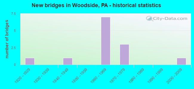
- New bridges - historical statistics
- 11920-1929
- 11940-1949
- 71960-1969
- 31970-1979
- 12000-2009


- Bridge Condition - Deck
- 50.0%Good
- 25.0%Satisfactory
- 25.0%Poor

- Bridge Condition - Superstructure
- 75.0%Satisfactory
- 25.0%Poor

- Bridge Condition - Substructure
- 50.0%Satisfactory
- 25.0%Fair
- 25.0%Poor

- Bridge Condition - Channel
- 33.3%Fair
- 66.7%Poor
Find on map >> Show street view
Structure Number: 7305, Location: 2MI.S.YARDLEY BOR. 38A03 (Lat: 40.214778, Lng: -74.858283), Route carried "on" structure: State highway , Year Built: 1926, Status: Open, Structure Length: 0.73m (2.40ft), Average Daily Traffic: 7,091 (year 2022), Truck Traffic: 3%, Average Future Daily Traffic: 9,413 (year 2032), Design Load: H 15, Features Intersected: BROCK CREEK, Facility Carried by Structure: STONY HILL ROAD
Minimum Vertical Clearance: 30+ m (98+ ft), Kilometerpoint: 4.117, Lanes on structure: 2, Owner: State Highway Agency, Approaching Roadway Width: 6.1m (20.0ft), Material/Design: Concrete, Design/Construction: Tee Beam, Number Of Spans In Main Unit: 1, Length of Maximum Span: 6.1m (20.0ft), Curb-To-Curb Width: 5.9m (19.4ft), Out-to-Out Width: 6.4m (21.0ft)
Condition: Deck: Poor, Superstructure: Poor, Substructure: Fair, Channel: Poor, Operating Rating: 56.2 metric tons, Method Used To Determine Operating Rating: Load Factor (LF), Inventory Rating: 33.6 metric tons, Method Used To Determine Inventory Rating: Load Factor (LF), Structural Evaluation: Meets minimum limits, Deck Geometry: High priority of replacement, Waterway Adequacy: Equal to present minimum criteria, Approach Roadway Alignment: Equal to present desirable criteria, Length Of Structure Improvement: 1.40m (4.59ft), Designated Inspection Frequency: Every 24 months, Inspection Date: May 2020, Bridge Improvement Cost: $25,000, Roadway Improvement Cost: $72,000, Total Project Cost: $332,000, Deck Structure Type: Concrete Cast-file-Place, Wearing Surface/Protective System: Wearing Surface: Bituminous
Find on map >> Show street view
Structure Number: 7306, Location: LOWER MAKEFIELD TP.37H01 (Lat: 40.224992, Lng: -74.881292), Route carried "on" structure: State highway , Year Built: 1972, Status: Open, Structure Length: 7.62m (25.00ft), Average Daily Traffic: 6,719 (year 2020), Truck Traffic: 2%, Average Future Daily Traffic: 12,915 (year 2032), Design Load: HS 20, Features Intersected: INTERSTATE 295, Facility Carried by Structure: STONEY HILL ROAD
Minimum Vertical Clearance: 30+ m (98+ ft), Kilometerpoint: 5.874, Lanes on structure: 2, Lanes under structure: 4, Owner: State Highway Agency, Approaching Roadway Width: 10.4m (34.1ft), Skew: 4 degrees, Material/Design: Steel continuous, Design/Construction: Stringer/Multi-beam, Number Of Spans In Main Unit: 2, Length of Maximum Span: 37.2m (122.0ft), Curb or Sidewalk Widths: Left: 0.2m (0.7ft), Right: 0.2m (0.7ft), Curb-To-Curb Width: 10.3m (33.8ft), Out-to-Out Width: 11.3m (37.1ft)
Condition: Deck: Satisfactory, Superstructure: Satisfactory, Substructure: Satisfactory, Operating Rating: 66.2 metric tons, Method Used To Determine Operating Rating: Load Factor (LF), Inventory Rating: 39.0 metric tons, Method Used To Determine Inventory Rating: Load Factor (LF), Structural Evaluation: Equal to present minimum criteria, Deck Geometry: Meets minimum limits, Underclear: Somewhat better than minimum adequacy, Approach Roadway Alignment: Better than present minimum criteria, Length Of Structure Improvement: 8.50m (27.89ft), Designated Inspection Frequency: Every 24 months, Inspection Date: July 2021, Bridge Improvement Cost: $46,000, Roadway Improvement Cost: $134,000, Total Project Cost: $615,000, Deck Structure Type: Concrete Cast-file-Place, Wearing Surface/Protective System: Wearing Surface: Bituminous
Find on map >> Show street view
Structure Number: 7323, Location: 1MI.S.TAYLORSVILLE 32J10 (Lat: 40.249639, Lng: -74.872114), Route carried "on" structure: State highway , Year Built: 1967, Status: Open, Structure Length: 6.10m (20.01ft), Average Daily Traffic: 2,256 (year 2022), Truck Traffic: 3%, Average Future Daily Traffic: 4,229 (year 2032), Design Load: HS 20, Features Intersected: INTERSTATE 295, Facility Carried by Structure: DOLINGTON ROAD
Minimum Vertical Clearance: 30+ m (98+ ft), Kilometerpoint: 2.229, Lanes on structure: 2, Lanes under structure: 4, Owner: State Highway Agency, Approaching Roadway Width: 11.6m (38.1ft), Material/Design: Prestressed concrete, Design/Construction: Stringer/Multi-beam, Number Of Spans In Main Unit: 2, Length of Maximum Span: 30.5m (100.1ft), Curb or Sidewalk Widths: Left: 0.2m (0.7ft), Right: 0.2m (0.7ft), Curb-To-Curb Width: 10.3m (33.8ft), Out-to-Out Width: 11.5m (37.7ft)
Condition: Deck: Good, Superstructure: Satisfactory, Substructure: Satisfactory, Operating Rating: 85.3 metric tons, Method Used To Determine Operating Rating: Load Factor (LF), Inventory Rating: 20.9 metric tons, Method Used To Determine Inventory Rating: Load Factor (LF), Structural Evaluation: Somewhat better than minimum adequacy, Deck Geometry: Meets minimum limits, Underclear: Equal to present minimum criteria, Approach Roadway Alignment: Better than present minimum criteria, Length Of Structure Improvement: 7.10m (23.29ft), Designated Inspection Frequency: Every 24 months, Inspection Date: June 2021, Bridge Improvement Cost: $33,000, Roadway Improvement Cost: $97,000, Total Project Cost: $444,000, Deck Structure Type: Concrete Cast-file-Place, Wearing Surface/Protective System: Wearing Surface: Monolithic Concrete
Find on map >> Show street view
Structure Number: 7647, Location: .75 Mi N. PA-532 3038-G5 (Lat: 40.282200, Lng: -74.897797), Route carried "on" structure: City street , Year Built: 1940, Year Reconstructed: 1985, Status: Open, Structure Length: 0.73m (2.40ft), Average Daily Traffic: 100 (year 2017), Truck Traffic: 5%, Average Future Daily Traffic: 265 (year 2037), Design Load: HS 20, Features Intersected: HOUGHS CREEK, Facility Carried by Structure: OLD DOLINGTON ROAD
Minimum Vertical Clearance: 30+ m (98+ ft), Kilometerpoint: 0.000, Lanes on structure: 1, Owner: Town or Township Highway Agency, Approaching Roadway Width: 4.3m (14.1ft), Skew: 1 degrees, Material/Design: Steel, Design/Construction: Stringer/Multi-beam, Number Of Spans In Main Unit: 1, Length of Maximum Span: 6.4m (21.0ft), Curb-To-Curb Width: 4.4m (14.4ft), Out-to-Out Width: 4.9m (16.1ft)
Condition: Deck: Good, Superstructure: Satisfactory, Substructure: Poor, Channel: Poor, Operating Rating: 58.1 metric tons, Method Used To Determine Operating Rating: Load Factor (LF), Inventory Rating: 34.5 metric tons, Method Used To Determine Inventory Rating: Load Factor (LF), Structural Evaluation: Meets minimum limits, Deck Geometry: Equal to present minimum criteria, Waterway Adequacy: Equal to present desirable criteria, Approach Roadway Alignment: Equal to present desirable criteria, Length Of Structure Improvement: 0.90m (2.95ft), Designated Inspection Frequency: Every 24 months, Inspection Date: July 2019, Bridge Improvement Cost: $2,000, Roadway Improvement Cost: $8,000, Total Project Cost: $21,000, Deck Structure Type: Concrete Cast-file-Place, Wearing Surface/Protective System: Wearing Surface: Bituminous
Find on map >> Show street view
Structure Number: 4124, Location: NE OF NEWTOWN 32E09 (Lat: 40.256808, Lng: -74.896892), Route carried "on" structure: State highway , Year Built: 2001, Status: Open, Structure Length: 0.64m (2.10ft), Average Daily Traffic: 8,095 (year 2022), Truck Traffic: 6%, Average Future Daily Traffic: 11,837 (year 2032), Design Load: HS 25 or greater, Features Intersected: CORE CREEK / 3038-G9, Facility Carried by Structure: LINDENHURST ROAD
Minimum Vertical Clearance: 30+ m (98+ ft), Kilometerpoint: 10.382, Lanes on structure: 2, Owner: State Highway Agency, Approaching Roadway Width: 9.1m (29.9ft), Skew: 2 degrees, Material/Design: Concrete, Design/Construction: Culvert, Number Of Spans In Main Unit: 2, Length of Maximum Span: 3.0m (9.8ft)
Condition: Channel: Fair, Culverts: Fair, Operating Rating: 68.9 metric tons, Method Used To Determine Operating Rating: Field evaluation and documented engineering judgment, Inventory Rating: 40.8 metric tons, Method Used To Determine Inventory Rating: Field evaluation and documented engineering judgment, Structural Evaluation: Somewhat better than minimum adequacy, Waterway Adequacy: Equal to present desirable criteria, Approach Roadway Alignment: Equal to present desirable criteria, Length Of Structure Improvement: 1.20m (3.94ft), Designated Inspection Frequency: Every 24 months, Inspection Date: October 2019
Find on map >> Show street view
Structure Number: 6878, Location: .8MI.N.RTE 332 32H11 (Lat: 40.245281, Lng: -74.878678), Route carried "under" structure: Interstate 295, Year Built: 1967, Structure Length: 0. m, Average Daily Traffic: 9,739 (year 2020), Truck Traffic: 10%, Features Intersected: INTERSTATE 295, Facility Carried by Structure: QUARRY ROAD (T359)
Minimum Vertical Clearance: 5.06m (16.60ft), Kilometerpoint: 14.484, Lanes on structure: 2, Lanes under structure: 2, Material/Design: Steel continuous, Design/Construction: Stringer/Multi-beam, Length of Maximum Span: 38.4m (126.0ft)
Find on map >> Show street view
Structure Number: 6878, Location: .8MI.N.RTE 332 32H11 (Lat: 40.245281, Lng: -74.878678), Route carried "under" structure: Interstate 295, Year Built: 1967, Structure Length: 0. m, Average Daily Traffic: 10,717 (year 2020), Truck Traffic: 10%, Features Intersected: INTERSTATE 295, Facility Carried by Structure: QUARRY ROAD (T359)
Minimum Vertical Clearance: 5.03m (16.50ft), Kilometerpoint: 14.484, Lanes on structure: 2, Lanes under structure: 2, Material/Design: Steel continuous, Design/Construction: Stringer/Multi-beam, Length of Maximum Span: 38.4m (126.0ft)
Find on map >> Show street view
Structure Number: 7008, Location: 1MI.W.YARDLEY RD. 32H13 (Lat: 40.234214, Lng: -74.882050), Route carried "under" structure: Interstate 295, Year Built: 1967, Structure Length: 0. m, Average Daily Traffic: 10,717 (year 2020), Truck Traffic: 10%, Features Intersected: INTERSTATE 295, Facility Carried by Structure: NEWTOWN YARDLEY RD
Minimum Vertical Clearance: 4.94m (16.21ft), Kilometerpoint: 12.875, Lanes on structure: 5, Lanes under structure: 2, Material/Design: Prestressed concrete continuous, Design/Construction: Stringer/Multi-beam, Length of Maximum Span: 30.8m (101.0ft)
Find on map >> Show street view
Structure Number: 7008, Location: 1MI.W.YARDLEY RD. 32H13 (Lat: 40.234214, Lng: -74.882050), Route carried "under" structure: Interstate 295, Year Built: 1967, Structure Length: 0. m, Average Daily Traffic: 9,739 (year 2020), Truck Traffic: 10%, Features Intersected: INTERSTATE 295, Facility Carried by Structure: NEWTOWN YARDLEY RD
Minimum Vertical Clearance: 4.97m (16.31ft), Kilometerpoint: 12.875, Lanes on structure: 5, Lanes under structure: 3, Material/Design: Prestressed concrete continuous, Design/Construction: Stringer/Multi-beam, Length of Maximum Span: 30.8m (101.0ft)
Find on map >> Show street view
Structure Number: 7306, Location: LOWER MAKEFIELD TP.37H01 (Lat: 40.224992, Lng: -74.881292), Route carried "under" structure: Interstate 295, Year Built: 1972, Structure Length: 0. m, Average Daily Traffic: 29,853 (year 2022), Truck Traffic: 9%, Features Intersected: INTERSTATE 295, Facility Carried by Structure: STONEY HILL ROAD
Minimum Vertical Clearance: 5.12m (16.80ft), Kilometerpoint: 12.070, Lanes on structure: 2, Lanes under structure: 2, Material/Design: Steel continuous, Design/Construction: Stringer/Multi-beam, Length of Maximum Span: 37.2m (122.0ft)
Find on map >> Show street view
Structure Number: 7306, Location: LOWER MAKEFIELD TP.37H01 (Lat: 40.224992, Lng: -74.881292), Route carried "under" structure: Interstate 295, Year Built: 1972, Structure Length: 0. m, Average Daily Traffic: 32,348 (year 2022), Truck Traffic: 10%, Features Intersected: INTERSTATE 295, Facility Carried by Structure: STONEY HILL ROAD
Minimum Vertical Clearance: 5.12m (16.80ft), Kilometerpoint: 12.070, Lanes on structure: 2, Lanes under structure: 2, Material/Design: Steel continuous, Design/Construction: Stringer/Multi-beam, Length of Maximum Span: 37.2m (122.0ft)
Find on map >> Show street view
Structure Number: 7323, Location: 1MI.S.TAYLORSVILLE 32J10 (Lat: 40.249639, Lng: -74.872114), Route carried "under" structure: Interstate 295, Year Built: 1967, Structure Length: 0. m, Average Daily Traffic: 9,739 (year 2020), Truck Traffic: 10%, Features Intersected: INTERSTATE 295, Facility Carried by Structure: DOLINGTON ROAD
Minimum Vertical Clearance: 5.66m (18.57ft), Kilometerpoint: 15.289, Lanes on structure: 2, Lanes under structure: 2, Material/Design: Prestressed concrete, Design/Construction: Stringer/Multi-beam, Length of Maximum Span: 30.5m (100.1ft)
Find on map >> Show street view
Structure Number: 7323, Location: 1MI.S.TAYLORSVILLE 32J10 (Lat: 40.249639, Lng: -74.872114), Route carried "under" structure: Interstate 295, Year Built: 1967, Structure Length: 0. m, Average Daily Traffic: 10,717 (year 2020), Truck Traffic: 10%, Features Intersected: INTERSTATE 295, Facility Carried by Structure: DOLINGTON ROAD
Minimum Vertical Clearance: 5.13m (16.83ft), Kilometerpoint: 15.289, Lanes on structure: 2, Lanes under structure: 2, Material/Design: Prestressed concrete, Design/Construction: Stringer/Multi-beam, Length of Maximum Span: 30.5m (100.1ft)