Bridge Statistics for Woodsboro, Maryland (MD)
Condition, Traffic, Stress, Structural Evaluation, Project Costs
- National Bridge Inventory (NBI) Statistics
- 10Number of bridges
- 161ft / 49.0mTotal length
- $40,000Total costs
- 15,677Total average daily traffic
- 1,532Total average daily truck traffic
- 23,137Total future (year 2026) average daily traffic
- National Bridge Inventory (NBI) Registered Bridges for Woodsboro
- No street view available for this location
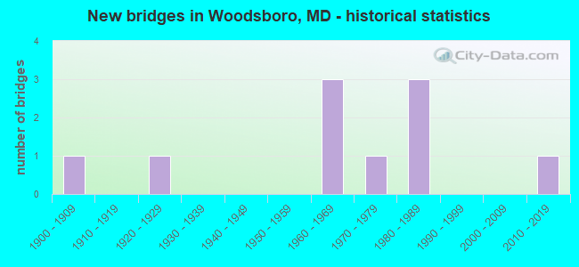
- New bridges - historical statistics
- 11900-1909
- 11920-1929
- 31960-1969
- 11970-1979
- 31980-1989
- 12010-2019


- Bridge Condition - Deck
- 16.7%Good
- 83.3%Satisfactory

- Bridge Condition - Superstructure
- 16.7%Good
- 83.3%Satisfactory

- Bridge Condition - Substructure
- 16.7%Very good
- 83.3%Satisfactory

- Bridge Condition - Channel
- 20.0%Good
- 80.0%Satisfactory

- Bridge Condition - Culverts
- 75.0%Good
- 25.0%Satisfactory
Find on map >> Show street view
Structure Number: 10000010009301, Location: 2.68 MILES N OF MD 194 (Lat: 39.562953, Lng: -77.351142), Route carried "on" structure: State highway 550, Year Built: 1967, Status: Open, Structure Length: 12.95m (42.49ft), Average Daily Traffic: 3,691 (year 2009), Truck Traffic: 8%, Average Future Daily Traffic: 5,537 (year 2029), Design Load: HS 20, Features Intersected: MONOCACY RIVER
Minimum Vertical Clearance: 30+ m (98+ ft), Kilometerpoint: 13.258, Lanes on structure: 2, Owner: State Highway Agency, Approaching Roadway Width: 13.4m (44.0ft), Skew: 2 degrees, Material/Design: Steel continuous, Design/Construction: Stringer/Multi-beam, Number Of Spans In Main Unit: 6, Length of Maximum Span: 22.9m (75.1ft), Curb or Sidewalk Widths: Left: 0.9m (3.0ft), Right: 0.9m (3.0ft), Curb-To-Curb Width: 9.1m (29.9ft), Out-to-Out Width: 11.6m (38.1ft)
Condition: Deck: Satisfactory, Superstructure: Satisfactory, Substructure: Satisfactory, Channel: Satisfactory, Operating Rating: 51.2 metric tons, Method Used To Determine Operating Rating: Load Factor (LF), Inventory Rating: 30.8 metric tons, Method Used To Determine Inventory Rating: Load Factor (LF), Structural Evaluation: Equal to present minimum criteria, Deck Geometry: Meets minimum limits, Waterway Adequacy: Superior to present desirable criteria, Approach Roadway Alignment: Equal to present desirable criteria, Designated Inspection Frequency: Every 24 months, Underwater Inspection Frequency: Every 48 months, Inspection Date: August 2020, Underwater Inspection Date: August 2018, Deck Structure Type: Concrete Cast-file-Place, Wearing Surface/Protective System: Wearing Surface: Monolithic Concrete
Find on map >> Show street view
Structure Number: 10000010009401, Location: 0.24 MILE SOUTH OF MD 194 (Lat: 39.530492, Lng: -77.307617), Route carried "on" structure: State highway 550, Year Built: 2015, Status: Open, Structure Length: 1.77m (5.81ft), Average Daily Traffic: 3,450 (year 2011), Truck Traffic: 20%, Average Future Daily Traffic: 6,250 (year 2031), Features Intersected: ISRAEL CREEK
Minimum Vertical Clearance: 30+ m (98+ ft), Kilometerpoint: 7.668, Lanes on structure: 2, Owner: State Highway Agency, Approaching Roadway Width: 9.1m (29.9ft), Skew: 1 degrees, Material/Design: Prestressed concrete, Design/Construction: Slab, Number Of Spans In Main Unit: 1, Length of Maximum Span: 16.8m (55.1ft), Curb-To-Curb Width: 9.1m (29.9ft), Out-to-Out Width: 10.4m (34.1ft)
Condition: Deck: Good, Superstructure: Good, Substructure: Very good, Channel: Satisfactory, Operating Rating: 97.2 metric tons, Method Used To Determine Operating Rating: Load and Resistance Factor Rating (LRFR) rating reported by rating factor(RF) method using HL-93 loadings, Inventory Rating: 82.9 metric tons, Method Used To Determine Inventory Rating: Load and Resistance Factor Rating (LRFR) rating reported by rating factor(RF) method using HL-93 loadings, Structural Evaluation: Better than present minimum criteria, Deck Geometry: Meets minimum limits, Waterway Adequacy: Equal to present minimum criteria, Approach Roadway Alignment: Equal to present desirable criteria, Designated Inspection Frequency: Every 24 months, Inspection Date: October 2021, Deck Structure Type: Concrete Cast-file-Place, Wearing Surface/Protective System: Wearing Surface: Monolithic Concrete, Deck Protection: Epoxy Coated Reinforcing
Find on map >> Show street view
Structure Number: 10000010009501, Location: 0.74 MILE SOUTH OF MD 194 (Lat: 39.527133, Lng: -77.299792), Route carried "on" structure: State highway 550, Year Built: 1925, Status: Open, Structure Length: 0.73m (2.40ft), Average Daily Traffic: 3,541 (year 2009), Truck Traffic: 8%, Average Future Daily Traffic: 4,313 (year 2026), Features Intersected: DORCUS BRANCH
Minimum Vertical Clearance: 30+ m (98+ ft), Kilometerpoint: 6.870, Lanes on structure: 2, Owner: State Highway Agency, Approaching Roadway Width: 6.7m (22.0ft), Skew: 4 degrees, Material/Design: Concrete, Design/Construction: Slab, Number Of Spans In Main Unit: 1, Length of Maximum Span: 6.1m (20.0ft), Curb-To-Curb Width: 7.0m (23.0ft), Out-to-Out Width: 7.6m (24.9ft)
Condition: Deck: Satisfactory, Superstructure: Satisfactory, Substructure: Satisfactory, Channel: Satisfactory, Operating Rating: 41.7 metric tons, Method Used To Determine Operating Rating: Load Factor (LF), Inventory Rating: 24.9 metric tons, Method Used To Determine Inventory Rating: Load Factor (LF), Structural Evaluation: Equal to present minimum criteria, Deck Geometry: High priority of replacement, Waterway Adequacy: Equal to present minimum criteria, Approach Roadway Alignment: Equal to present desirable criteria, Length Of Structure Improvement: 0.73m (2.40ft), Designated Inspection Frequency: Every 12 months, Inspection Date: June 2021, Bridge Improvement Cost: $36,000, Roadway Improvement Cost: $4,000, Total Project Cost: $40,000, Deck Structure Type: Concrete Cast-file-Place, Wearing Surface/Protective System: Wearing Surface: Monolithic Concrete
Find on map >> Show street view
Structure Number: 200000F-040401, Location: 1.8 MI E OF MD 550 (Lat: 39.585547, Lng: -77.335161), Route carried "on" structure: County highway 543, Year Built: 1979, Status: Open, Structure Length: 3.81m (12.50ft), Average Daily Traffic: 603 (year 2020), Truck Traffic: 5%, Average Future Daily Traffic: 900 (year 2040), Design Load: HS 20, Features Intersected: OWENS CREEK, Facility Carried by Structure: LONGS MILL ROAD
Minimum Vertical Clearance: 30+ m (98+ ft), Kilometerpoint: 2.944, Lanes on structure: 2, Owner: County Highway Agency, Approaching Roadway Width: 12.2m (40.0ft), Skew: 1 degrees, Material/Design: Steel continuous, Design/Construction: Stringer/Multi-beam, Number Of Spans In Main Unit: 3, Length of Maximum Span: 16.2m (53.1ft), Curb-To-Curb Width: 12.2m (40.0ft), Out-to-Out Width: 13.2m (43.3ft)
Condition: Deck: Satisfactory, Superstructure: Satisfactory, Substructure: Satisfactory, Channel: Good, Operating Rating: 65.8 metric tons, Method Used To Determine Operating Rating: Load Factor (LF), Inventory Rating: 39.5 metric tons, Method Used To Determine Inventory Rating: Load Factor (LF), Structural Evaluation: Equal to present minimum criteria, Deck Geometry: Equal to present desirable criteria, Waterway Adequacy: Superior to present desirable criteria, Approach Roadway Alignment: Equal to present minimum criteria, Designated Inspection Frequency: Every 24 months, Inspection Date: June 2020, Deck Structure Type: Concrete Cast-file-Place, Wearing Surface/Protective System: Wearing Surface: Monolithic Concrete, Deck Protection: Epoxy Coated Reinforcing
Find on map >> Show street view
Structure Number: 200000F-041001, Location: 3 MI N OF WOODSBORO (Lat: 39.581069, Lng: -77.313747), Route carried "on" structure: County highway 526, Year Built: 1903, Year Reconstructed: 2009, Status: Open, Structure Length: 7.53m (24.70ft), Average Daily Traffic: 691 (year 2020), Truck Traffic: 5%, Average Future Daily Traffic: 1,030 (year 2040), Features Intersected: MONOCACY RIVER, Facility Carried by Structure: LEGORE BRIDGE ROAD
Minimum Vertical Clearance: 30+ m (98+ ft), Kilometerpoint: 1.979, Lanes on structure: 2, Owner: County Highway Agency, Approaching Roadway Width: 6.1m (20.0ft), Material/Design: Masonry, Design/Construction: Arch - Deck, Number Of Spans In Main Unit: 4, Number Of Approach Spans: 1, Length of Maximum Span: 19.2m (63.0ft), Curb-To-Curb Width: 5.6m (18.4ft), Out-to-Out Width: 7.6m (24.9ft)
Condition: Deck: Satisfactory, Superstructure: Satisfactory, Substructure: Satisfactory, Channel: Satisfactory, Operating Rating: 43.5 metric tons, Method Used To Determine Operating Rating: Field evaluation and documented engineering judgment, Inventory Rating: 32.7 metric tons, Method Used To Determine Inventory Rating: Field evaluation and documented engineering judgment, Structural Evaluation: Equal to present minimum criteria, Deck Geometry: High priority of replacement, Waterway Adequacy: Equal to present desirable criteria, Approach Roadway Alignment: High priority of corrective action, Designated Inspection Frequency: Every 24 months, Inspection Date: June 2020, Wearing Surface/Protective System: Wearing Surface: Bituminous
Find on map >> Show street view
Structure Number: 200000F-110101, Location: 0.18 MI W OF DUBLIN ROAD (Lat: 39.534183, Lng: -77.352369), Route carried "on" structure: County highway 839, Year Built: 1980, Status: Open, Structure Length: 16.70m (54.79ft), Average Daily Traffic: 1,047 (year 2018), Truck Traffic: 5%, Average Future Daily Traffic: 1,555 (year 2038), Design Load: HS 20, Features Intersected: MONOCACY RIVER, Facility Carried by Structure: LINKS BRIDGE ROAD
Minimum Vertical Clearance: 30+ m (98+ ft), Kilometerpoint: 2.590, Lanes on structure: 2, Owner: County Highway Agency, Approaching Roadway Width: 12.2m (40.0ft), Skew: 2 degrees, Material/Design: Steel continuous, Design/Construction: Stringer/Multi-beam, Number Of Spans In Main Unit: 4, Length of Maximum Span: 67.7m (222.1ft), Curb-To-Curb Width: 12.2m (40.0ft), Out-to-Out Width: 13.2m (43.3ft)
Condition: Deck: Satisfactory, Superstructure: Satisfactory, Substructure: Satisfactory, Channel: Satisfactory, Operating Rating: 78.5 metric tons, Method Used To Determine Operating Rating: Allowable Stress (AS), Inventory Rating: 47.2 metric tons, Method Used To Determine Inventory Rating: Allowable Stress (AS), Structural Evaluation: Equal to present minimum criteria, Deck Geometry: Better than present minimum criteria, Waterway Adequacy: Superior to present desirable criteria, Approach Roadway Alignment: Equal to present desirable criteria, Designated Inspection Frequency: Every 24 months, Inspection Date: June 2020, Deck Structure Type: Concrete Cast-file-Place, Wearing Surface/Protective System: Wearing Surface: Integral Concrete, Deck Protection: Epoxy Coated Reinforcing
Find on map >> Show street view
Structure Number: 200000F-110302, Location: 0.3 MI EAST OF MD RTE 194 (Lat: 39.537689, Lng: -77.309214), Route carried "on" structure: County highway 466, Year Built: 1966, Status: Open, Structure Length: 2.01m (6.59ft), Average Daily Traffic: 2,172 (year 2007), Truck Traffic: 5%, Average Future Daily Traffic: 2,606 (year 2032), Design Load: H 20, Features Intersected: ISRAEL CREEK, Facility Carried by Structure: COPPERMINE ROAD
Minimum Vertical Clearance: 30+ m (98+ ft), Kilometerpoint: 12.309, Lanes on structure: 2, Owner: County Highway Agency, Approaching Roadway Width: 6.1m (20.0ft), Skew: 1 degrees, Material/Design: Concrete, Design/Construction: Culvert, Length of Maximum Span: 0.0m
Condition: Channel: Satisfactory, Culverts: Good, Operating Rating: 53.5 metric tons, Method Used To Determine Operating Rating: Load Factor (LF), Inventory Rating: 32.2 metric tons, Method Used To Determine Inventory Rating: Load Factor (LF), Structural Evaluation: Better than present minimum criteria, Waterway Adequacy: Somewhat better than minimum adequacy, Approach Roadway Alignment: Equal to present desirable criteria, Designated Inspection Frequency: Every 24 months, Inspection Date: August 2021
Find on map >> Show street view
Structure Number: 200000F-111003, Location: 0.25 MI N OF COPPERMINE R (Lat: 39.541236, Lng: -77.301939), Route carried "on" structure: County highway 474, Year Built: 1982, Year Reconstructed: 2007, Status: Open, Structure Length: 1.16m (3.81ft), Average Daily Traffic: 80 (year 2007), Truck Traffic: 1%, Average Future Daily Traffic: 96 (year 2032), Features Intersected: ISRAEL CREEK, Facility Carried by Structure: CASH SMITH ROAD
Minimum Vertical Clearance: 30+ m (98+ ft), Kilometerpoint: 0.386, Lanes on structure: 2, Owner: County Highway Agency, Approaching Roadway Width: 4.3m (14.1ft), Material/Design: Steel, Design/Construction: Culvert, Length of Maximum Span: 0.0m
Condition: Channel: Satisfactory, Culverts: Good, Structural Evaluation: Better than present minimum criteria, Waterway Adequacy: Equal to present minimum criteria, Approach Roadway Alignment: Equal to present minimum criteria, Designated Inspection Frequency: Every 24 months, Inspection Date: May 2021
Find on map >> Show street view
Structure Number: 200000F-111303, Location: 425 FT SOUTH OF MD 550 (Lat: 39.525144, Lng: -77.297897), Route carried "on" structure: County highway 462, Year Built: 1963, Status: Open, Structure Length: 0.73m (2.40ft), Average Daily Traffic: 200 (year 2007), Truck Traffic: 10%, Average Future Daily Traffic: 300 (year 2027), Features Intersected: DORCUS BRANCH, Facility Carried by Structure: HOFFMAN SEACHRIST
Minimum Vertical Clearance: 30+ m (98+ ft), Kilometerpoint: 0.000, Lanes on structure: 2, Owner: County Highway Agency, Approaching Roadway Width: 6.1m (20.0ft), Material/Design: Concrete, Design/Construction: Culvert, Number Of Spans In Main Unit: 3, Length of Maximum Span: 1.8m (5.9ft)
Condition: Channel: Satisfactory, Culverts: Satisfactory, Structural Evaluation: Equal to present minimum criteria, Waterway Adequacy: Equal to present desirable criteria, Approach Roadway Alignment: Equal to present desirable criteria, Designated Inspection Frequency: Every 24 months, Inspection Date: May 2021
Find on map >> Show street view
Structure Number: 200000F-261303, Location: 100' N OF BENNIE DUNCAN R (Lat: 39.498283, Lng: -77.306561), Route carried "on" structure: County highway 462, Year Built: 1985, Status: Open, Structure Length: 1.65m (5.41ft), Average Daily Traffic: 202 (year 2009), Truck Traffic: 10%, Average Future Daily Traffic: 550 (year 2036), Features Intersected: CABBAGE RUN, Facility Carried by Structure: HOFFMAN SEACHRIST
Minimum Vertical Clearance: 30+ m (98+ ft), Kilometerpoint: 0.000, Lanes on structure: 2, Owner: County Highway Agency, Approaching Roadway Width: 12.2m (40.0ft), Material/Design: Steel, Design/Construction: Culvert, Length of Maximum Span: 0.0m
Condition: Channel: Good, Culverts: Good, Operating Rating: 89.8 metric tons, Method Used To Determine Operating Rating: Load Factor (LF), Inventory Rating: 87.5 metric tons, Method Used To Determine Inventory Rating: Load Factor (LF), Structural Evaluation: Better than present minimum criteria, Waterway Adequacy: Better than present minimum criteria, Approach Roadway Alignment: Equal to present desirable criteria, Designated Inspection Frequency: Every 24 months, Inspection Date: May 2021