Bridge Statistics for Woodland Park, Nebraska (NE)
Condition, Traffic, Stress, Structural Evaluation, Project Costs
- National Bridge Inventory (NBI) Statistics
- 19Number of bridges
- 59ft / 18.1mTotal length
- 21,375Total average daily traffic
- 3,548Total average daily truck traffic
- 34,228Total future (year 2033) average daily traffic
- National Bridge Inventory (NBI) Registered Bridges for Woodland Park
- No street view available for this location
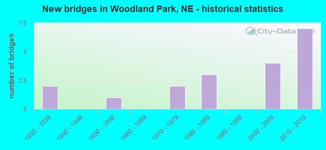
- New bridges - historical statistics
- 21930-1939
- 11950-1959
- 21970-1979
- 31980-1989
- 42000-2009
- 72010-2019


- Bridge Condition - Deck
- 16.7%Good
- 50.0%Fair
- 33.3%Serious

- Bridge Condition - Superstructure
- 50.0%Good
- 16.7%Satisfactory
- 16.7%Fair
- 16.7%Serious

- Bridge Condition - Substructure
- 66.7%Good
- 16.7%Fair
- 16.7%Serious

- Bridge Condition - Channel
- 21.1%Excellent
- 15.8%Very good
- 21.1%Good
- 36.8%Satisfactory
- 5.3%Fair

- Bridge Condition - Culverts
- 30.8%Excellent
- 46.2%Very good
- 15.4%Good
- 7.7%Fair
Find on map >> Show street view
Structure Number: C008400205, Location: 1W N35 WAYNE CL (Lat: 42.090000, Lng: -97.331700), Route carried "on" structure: County highway 2, Year Built: 2010, Status: Open, Structure Length: 1.16m (3.81ft), Average Daily Traffic: 30 (year 2003), Average Future Daily Traffic: 51 (year 2033), Design Load: HS 20, Features Intersected: SPRING BRANCH, Facility Carried by Structure: COUNTY HIGHWAY
Minimum Vertical Clearance: 30+ m (98+ ft), Kilometerpoint: 0.000, Lanes on structure: 2, Owner: County Highway Agency, Approaching Roadway Width: 8.5m (27.9ft), Skew: 1 degrees, Material/Design: Concrete, Design/Construction: Culvert, Number Of Spans In Main Unit: 3, Length of Maximum Span: 3.7m (12.1ft)
Condition: Channel: Good, Culverts: Very good, Operating Rating: 79.0 metric tons, Method Used To Determine Operating Rating: Load Factor (LF), Inventory Rating: 47.0 metric tons, Method Used To Determine Inventory Rating: Load Factor (LF), Structural Evaluation: Equal to present desirable criteria, Waterway Adequacy: Superior to present desirable criteria, Approach Roadway Alignment: Equal to present desirable criteria, Length Of Structure Improvement: 1.25m (4.10ft), Designated Inspection Frequency: Every 24 months, Inspection Date: September 2020
Find on map >> Show street view
Structure Number: C008400405, Location: JCT US275/N57 5.5W 4N (Lat: 42.077000, Lng: -97.318000), Route carried "on" structure: County highway 3090, Year Built: 2017, Status: Open, Structure Length: 1.10m (3.61ft), Average Daily Traffic: 135 (year 2011), Average Future Daily Traffic: 140 (year 2033), Design Load: HL 93, Features Intersected: STREAM
Minimum Vertical Clearance: 30+ m (98+ ft), Kilometerpoint: 0.093, Lanes on structure: 2, Owner: County Highway Agency, Approaching Roadway Width: 8.5m (27.9ft), Material/Design: Concrete, Design/Construction: Culvert, Number Of Spans In Main Unit: 3, Length of Maximum Span: 3.7m (12.1ft)
Condition: Channel: Good, Culverts: Excellent, Operating Rating: 43.0 metric tons, Method Used To Determine Operating Rating: Load and Resistance Factor (LRFR), Inventory Rating: 33.0 metric tons, Method Used To Determine Inventory Rating: Load and Resistance Factor (LRFR), Structural Evaluation: Superior to present desirable criteria, Waterway Adequacy: Better than present minimum criteria, Approach Roadway Alignment: Equal to present desirable criteria, Length Of Structure Improvement: 1.22m (4.00ft), Designated Inspection Frequency: Every 24 months, Inspection Date: September 2020
Find on map >> Show street view
Structure Number: C008400605, Location: 7.2N 7.9W OF STANTON (Lat: 42.061700, Lng: -97.365000), Route carried "on" structure: County highway 6, Year Built: 1978, Status: Open, Structure Length: 0.91m (2.99ft), Average Daily Traffic: 50 (year 2003), Average Future Daily Traffic: 85 (year 2033), Features Intersected: STREAM, Facility Carried by Structure: COUNTY HIGHWAY
Minimum Vertical Clearance: 30+ m (98+ ft), Kilometerpoint: 0.000, Lanes on structure: 2, Owner: County Highway Agency, Approaching Roadway Width: 6.7m (22.0ft), Material/Design: Steel, Design/Construction: Stringer/Multi-beam, Number Of Spans In Main Unit: 1, Length of Maximum Span: 8.8m (28.9ft), Curb-To-Curb Width: 8.4m (27.6ft), Out-to-Out Width: 8.5m (27.9ft)
Condition: Deck: Fair, Superstructure: Good, Substructure: Good, Channel: Satisfactory, Operating Rating: 46.0 metric tons, Method Used To Determine Operating Rating: Load Factor (LF), Inventory Rating: 27.0 metric tons, Method Used To Determine Inventory Rating: Load Factor (LF), Structural Evaluation: Equal to present minimum criteria, Deck Geometry: Equal to present minimum criteria, Waterway Adequacy: Equal to present minimum criteria, Approach Roadway Alignment: Equal to present minimum criteria, Designated Inspection Frequency: Every 24 months, Inspection Date: September 2020, Deck Structure Type: Concrete Cast-file-Place, Wearing Surface/Protective System: Wearing Surface: Monolithic Concrete
Find on map >> Show street view
Structure Number: C008401005, Location: 5N & 3W OF STANTON (Lat: 42.033100, Lng: -97.306200), Route carried "on" structure: County highway 10, Year Built: 2017, Status: Open, Structure Length: 0.78m (2.56ft), Average Daily Traffic: 10 (year 2003), Average Future Daily Traffic: 17 (year 2033), Features Intersected: PLEASANT RUN TRIBUTARY, Facility Carried by Structure: 842ND RD
Minimum Vertical Clearance: 30+ m (98+ ft), Kilometerpoint: 0.000, Lanes on structure: 2, Owner: County Highway Agency, Approaching Roadway Width: 8.5m (27.9ft), Skew: 2 degrees, Material/Design: Steel, Design/Construction: Culvert, Number Of Spans In Main Unit: 3, Length of Maximum Span: 1.9m (6.2ft)
Condition: Channel: Excellent, Culverts: Excellent, Operating Rating: 43.0 metric tons, Method Used To Determine Operating Rating: Load Factor (LF), Inventory Rating: 33.0 metric tons, Method Used To Determine Inventory Rating: Load Factor (LF), Structural Evaluation: Superior to present desirable criteria, Waterway Adequacy: Superior to present desirable criteria, Approach Roadway Alignment: Superior to present desirable criteria, Designated Inspection Frequency: Every 24 months, Inspection Date: September 2020
Find on map >> Show street view
Structure Number: C008401007, Location: 5N & 3W OF STANTON (Lat: 42.033100, Lng: -97.302100), Route carried "on" structure: County highway 10, Year Built: 2017, Status: Open, Structure Length: 0.64m (2.10ft), Average Daily Traffic: 10 (year 2003), Average Future Daily Traffic: 17 (year 2033), Features Intersected: PLEASANT RUN TRIBUTARY, Facility Carried by Structure: 842ND RD
Minimum Vertical Clearance: 30+ m (98+ ft), Kilometerpoint: 0.000, Lanes on structure: 2, Owner: County Highway Agency, Approaching Roadway Width: 8.5m (27.9ft), Material/Design: Steel, Design/Construction: Culvert, Number Of Spans In Main Unit: 3, Length of Maximum Span: 1.5m (4.9ft)
Condition: Channel: Excellent, Culverts: Excellent, Operating Rating: 43.0 metric tons, Method Used To Determine Operating Rating: Load Factor (LF), Inventory Rating: 33.0 metric tons, Method Used To Determine Inventory Rating: Load Factor (LF), Structural Evaluation: Superior to present desirable criteria, Waterway Adequacy: Superior to present desirable criteria, Approach Roadway Alignment: Superior to present desirable criteria, Designated Inspection Frequency: Every 24 months, Inspection Date: September 2020
Find on map >> Show street view
Structure Number: C00840101, Location: 2.9W 6N OF STANTON (Lat: 42.033300, Lng: -97.288300), Route carried "on" structure: County highway 10, Year Built: 2007, Status: Open, Structure Length: 0.76m (2.49ft), Average Daily Traffic: 10 (year 2003), Average Future Daily Traffic: 17 (year 2033), Design Load: HS 20, Features Intersected: PLEASANT RUN CREEK TRIB, Facility Carried by Structure: COUNTY HIGHWAY
Minimum Vertical Clearance: 30+ m (98+ ft), Kilometerpoint: 0.000, Lanes on structure: 2, Owner: County Highway Agency, Approaching Roadway Width: 8.5m (27.9ft), Skew: 2 degrees, Material/Design: Concrete, Design/Construction: Culvert, Number Of Spans In Main Unit: 2, Length of Maximum Span: 3.7m (12.1ft)
Condition: Channel: Satisfactory, Culverts: Very good, Operating Rating: 33.0 metric tons, Method Used To Determine Operating Rating: Field evaluation and documented engineering judgment, Inventory Rating: 22.0 metric tons, Method Used To Determine Inventory Rating: Field evaluation and documented engineering judgment, Structural Evaluation: Equal to present minimum criteria, Waterway Adequacy: Meets minimum limits, Approach Roadway Alignment: Equal to present desirable criteria, Length Of Structure Improvement: 1.01m (3.31ft), Designated Inspection Frequency: Every 24 months, Inspection Date: September 2021
Find on map >> Show street view
Structure Number: C008401405, Location: 5.1W 4N OF STANTON (Lat: 42.003300, Lng: -97.333300), Route carried "on" structure: County highway 14, Year Built: 2007, Status: Open, Structure Length: 0.79m (2.59ft), Average Daily Traffic: 30 (year 2003), Average Future Daily Traffic: 51 (year 2033), Design Load: HS 20, Features Intersected: TRIB TO ELKHORN RIV, Facility Carried by Structure: COUNTY HIGHWAY
Minimum Vertical Clearance: 30+ m (98+ ft), Kilometerpoint: 0.000, Lanes on structure: 2, Owner: County Highway Agency, Approaching Roadway Width: 8.5m (27.9ft), Skew: 1 degrees, Material/Design: Concrete, Design/Construction: Culvert, Number Of Spans In Main Unit: 2, Length of Maximum Span: 3.7m (12.1ft)
Condition: Channel: Good, Culverts: Good, Operating Rating: 33.0 metric tons, Method Used To Determine Operating Rating: Field evaluation and documented engineering judgment, Inventory Rating: 22.0 metric tons, Method Used To Determine Inventory Rating: Field evaluation and documented engineering judgment, Structural Evaluation: Equal to present minimum criteria, Waterway Adequacy: Somewhat better than minimum adequacy, Approach Roadway Alignment: Equal to present desirable criteria, Length Of Structure Improvement: 1.43m (4.69ft), Designated Inspection Frequency: Every 24 months, Inspection Date: September 2021
Find on map >> Show street view
Structure Number: C00842014, Location: 3N N35 MADISON CL (Lat: 42.081700, Lng: -97.368300), Route carried "on" structure: County highway 201, Year Built: 1955, Status: Closed, Structure Length: 1.13m (3.71ft), Average Daily Traffic: 10 (year 2003), Average Future Daily Traffic: 17 (year 2033), Features Intersected: STREAM, Facility Carried by Structure: COUNTY HIGHWAY
Minimum Vertical Clearance: 30+ m (98+ ft), Kilometerpoint: 0.000, Lanes on structure: 2, Owner: County Highway Agency, Approaching Roadway Width: 5.5m (18.0ft), Material/Design: Wood or Timber, Design/Construction: Stringer/Multi-beam, Number Of Spans In Main Unit: 2, Length of Maximum Span: 7.9m (25.9ft), Curb-To-Curb Width: 4.9m (16.1ft), Out-to-Out Width: 4.9m (16.1ft)
Condition: Deck: Serious, Superstructure: Serious, Substructure: Fair, Channel: Satisfactory, Deck Geometry: High priority of corrective action, Waterway Adequacy: Equal to present minimum criteria, Approach Roadway Alignment: Somewhat better than minimum adequacy, Bridge Posting: Required (Relationship of Operating Rating to Maximum Legal Load: > 39.9% below), Length Of Structure Improvement: 1.13m (3.71ft), Designated Inspection Frequency: Every 24 months, Inspection Date: September 2021, Deck Structure Type: Wood or Timber, Wearing Surface/Protective System: Wearing Surface: Wood or Timber
Find on map >> Show street view
Structure Number: C008420535, Location: 5W 9.6N OF STANTON (Lat: 42.085000, Lng: -97.330000), Route carried "on" structure: County highway 205, Year Built: 1935, Status: Closed, Structure Length: 1.22m (4.00ft), Average Daily Traffic: 5 (year 2003), Average Future Daily Traffic: 8 (year 2033), Features Intersected: STREAM, Facility Carried by Structure: COUNTY HIGHWAY
Minimum Vertical Clearance: 30+ m (98+ ft), Kilometerpoint: 0.000, Lanes on structure: 1, Owner: County Highway Agency, Approaching Roadway Width: 4.9m (16.1ft), Material/Design: Steel, Design/Construction: Girder and Floorbeam System, Number Of Spans In Main Unit: 1, Length of Maximum Span: 11.9m (39.0ft), Curb-To-Curb Width: 4.8m (15.7ft), Out-to-Out Width: 4.9m (16.1ft)
Condition: Deck: Serious, Superstructure: Fair, Substructure: Serious, Channel: Satisfactory, Deck Geometry: Equal to present desirable criteria, Waterway Adequacy: Equal to present minimum criteria, Approach Roadway Alignment: Meets minimum limits, Bridge Posting: Required (Relationship of Operating Rating to Maximum Legal Load: > 39.9% below), Length Of Structure Improvement: 1.22m (4.00ft), Designated Inspection Frequency: Every 24 months, Inspection Date: September 2021, Deck Structure Type: Wood or Timber, Wearing Surface/Protective System: Wearing Surface: Wood or Timber
Find on map >> Show street view
Structure Number: C008420725, Location: 4W 6.1N OF STANTON (Lat: 42.036000, Lng: -97.310400), Route carried "on" structure: County highway 207, Year Built: 1985, Status: Open, Structure Length: 0.91m (2.99ft), Average Daily Traffic: 30 (year 2003), Average Future Daily Traffic: 51 (year 2033), Features Intersected: PLEASANT RUN CREEK, Facility Carried by Structure: COUNTY HIGHWAY
Minimum Vertical Clearance: 30+ m (98+ ft), Kilometerpoint: 0.000, Lanes on structure: 2, Owner: County Highway Agency, Approaching Roadway Width: 7.3m (24.0ft), Skew: 3 degrees, Material/Design: Concrete, Design/Construction: Stringer/Multi-beam, Number Of Spans In Main Unit: 1, Length of Maximum Span: 8.5m (27.9ft), Curb-To-Curb Width: 8.5m (27.9ft), Out-to-Out Width: 8.7m (28.5ft)
Condition: Deck: Fair, Superstructure: Satisfactory, Substructure: Good, Channel: Satisfactory, Operating Rating: 33.0 metric tons, Method Used To Determine Operating Rating: Field evaluation and documented engineering judgment, Inventory Rating: 22.0 metric tons, Method Used To Determine Inventory Rating: Field evaluation and documented engineering judgment, Structural Evaluation: Equal to present minimum criteria, Deck Geometry: Better than present minimum criteria, Waterway Adequacy: Meets minimum limits, Approach Roadway Alignment: Better than present minimum criteria, Designated Inspection Frequency: Every 24 months, Inspection Date: September 2021, Deck Structure Type: Concrete Precast Panels, Wearing Surface/Protective System: Wearing Surface: Monolithic Concrete
Find on map >> Show street view
Structure Number: C00842094, Location: 3W 4.5N OF STANTON (Lat: 42.010000, Lng: -97.291700), Route carried "on" structure: County highway 209, Year Built: 2009, Status: Open, Structure Length: 1.01m (3.31ft), Average Daily Traffic: 20 (year 2003), Average Future Daily Traffic: 34 (year 2033), Design Load: HS 20, Features Intersected: STREAM, Facility Carried by Structure: COUNTY HIGHWAY
Minimum Vertical Clearance: 30+ m (98+ ft), Kilometerpoint: 0.000, Lanes on structure: 2, Owner: County Highway Agency, Approaching Roadway Width: 8.5m (27.9ft), Material/Design: Concrete, Design/Construction: Culvert, Number Of Spans In Main Unit: 3, Length of Maximum Span: 3.0m (9.8ft)
Condition: Channel: Excellent, Culverts: Very good, Operating Rating: 81.0 metric tons, Method Used To Determine Operating Rating: Load Factor (LF), Inventory Rating: 48.0 metric tons, Method Used To Determine Inventory Rating: Load Factor (LF), Structural Evaluation: Equal to present desirable criteria, Waterway Adequacy: Better than present minimum criteria, Approach Roadway Alignment: Equal to present desirable criteria, Length Of Structure Improvement: 0.91m (2.99ft), Designated Inspection Frequency: Every 24 months, Inspection Date: September 2020
Find on map >> Show street view
Structure Number: C00843033, Location: JCT US275/N57 7W 3.8N (Lat: 42.071700, Lng: -97.333300), Route carried "on" structure: County highway 303, Year Built: 1975, Status: Open, Structure Length: 0.76m (2.49ft), Average Daily Traffic: 725 (year 2003), Truck Traffic: 10%, Average Future Daily Traffic: 1,232 (year 2033), Features Intersected: STREAM, Facility Carried by Structure: COUNTY HIGHWAY
Minimum Vertical Clearance: 30+ m (98+ ft), Kilometerpoint: 0.000, Lanes on structure: 2, Owner: County Highway Agency, Approaching Roadway Width: 7.3m (24.0ft), Material/Design: Steel, Design/Construction: Stringer/Multi-beam, Number Of Spans In Main Unit: 1, Length of Maximum Span: 7.3m (24.0ft), Curb-To-Curb Width: 8.3m (27.2ft), Out-to-Out Width: 8.5m (27.9ft)
Condition: Deck: Good, Superstructure: Good, Substructure: Good, Channel: Satisfactory, Operating Rating: 39.0 metric tons, Method Used To Determine Operating Rating: Load Factor (LF), Inventory Rating: 24.0 metric tons, Method Used To Determine Inventory Rating: Load Factor (LF), Structural Evaluation: Equal to present minimum criteria, Deck Geometry: Somewhat better than minimum adequacy, Waterway Adequacy: Meets minimum limits, Approach Roadway Alignment: Equal to present desirable criteria, Designated Inspection Frequency: Every 24 months, Inspection Date: September 2020, Deck Structure Type: Concrete Cast-file-Place, Wearing Surface/Protective System: Wearing Surface: Monolithic Concrete
Find on map >> Show street view
Structure Number: C008430335, Location: 6W 9.5N OF STANTON (Lat: 42.083300, Lng: -97.333300), Route carried "on" structure: County highway 303, Year Built: 1986, Status: Open, Structure Length: 1.65m (5.41ft), Average Daily Traffic: 100 (year 2003), Truck Traffic: 10%, Average Future Daily Traffic: 170 (year 2033), Features Intersected: SPRING CREEK, Facility Carried by Structure: COUNTY HIGHWAY
Minimum Vertical Clearance: 30+ m (98+ ft), Kilometerpoint: 0.000, Lanes on structure: 2, Owner: County Highway Agency, Approaching Roadway Width: 6.7m (22.0ft), Material/Design: Steel, Design/Construction: Stringer/Multi-beam, Number Of Spans In Main Unit: 1, Length of Maximum Span: 16.2m (53.1ft), Curb-To-Curb Width: 7.9m (25.9ft), Out-to-Out Width: 8.1m (26.6ft)
Condition: Deck: Fair, Superstructure: Good, Substructure: Good, Channel: Satisfactory, Operating Rating: 50.0 metric tons, Method Used To Determine Operating Rating: Load Factor (LF), Inventory Rating: 30.0 metric tons, Method Used To Determine Inventory Rating: Load Factor (LF), Structural Evaluation: Better than present minimum criteria, Deck Geometry: Equal to present minimum criteria, Waterway Adequacy: Equal to present desirable criteria, Approach Roadway Alignment: Better than present minimum criteria, Designated Inspection Frequency: Every 24 months, Inspection Date: September 2021, Deck Structure Type: Concrete Cast-file-Place, Wearing Surface/Protective System: Wearing Surface: Monolithic Concrete
Find on map >> Show street view
Structure Number: C00844303, Location: 3W 5.3N OF STANTON (Lat: 42.023700, Lng: -97.291000), Route carried "on" structure: County highway 10, Year Built: 2015, Status: Open, Structure Length: 0.91m (2.99ft), Average Daily Traffic: 10 (year 2003), Average Future Daily Traffic: 17 (year 2033), Features Intersected: PLEASANT RUN CREEK, Facility Carried by Structure: 562 AVE
Minimum Vertical Clearance: 30+ m (98+ ft), Kilometerpoint: 0.000, Lanes on structure: 2, Owner: County Highway Agency, Approaching Roadway Width: 8.5m (27.9ft), Material/Design: Steel, Design/Construction: Culvert, Number Of Spans In Main Unit: 3, Length of Maximum Span: 2.4m (7.9ft)
Condition: Channel: Good, Culverts: Very good, Operating Rating: 43.0 metric tons, Method Used To Determine Operating Rating: Load and Resistance Factor (LRFR), Inventory Rating: 33.0 metric tons, Method Used To Determine Inventory Rating: Load and Resistance Factor (LRFR), Structural Evaluation: Equal to present desirable criteria, Waterway Adequacy: Meets minimum limits, Approach Roadway Alignment: Equal to present desirable criteria, Designated Inspection Frequency: Every 24 months, Inspection Date: September 2021
Find on map >> Show street view
Structure Number: C00844304, Location: 3W 6.5N OF STANTON (Lat: 42.040400, Lng: -97.291000), Route carried "on" structure: County highway 10, Year Built: 2015, Status: Open, Structure Length: 0.78m (2.56ft), Average Daily Traffic: 10 (year 2003), Average Future Daily Traffic: 17 (year 2033), Design Load: HS 20, Features Intersected: STREAM, Facility Carried by Structure: 562 AVE
Minimum Vertical Clearance: 30+ m (98+ ft), Kilometerpoint: 0.000, Lanes on structure: 2, Owner: County Highway Agency, Approaching Roadway Width: 8.5m (27.9ft), Skew: 2 degrees, Material/Design: Steel, Design/Construction: Culvert, Number Of Spans In Main Unit: 3, Length of Maximum Span: 1.9m (6.2ft)
Condition: Channel: Fair, Culverts: Good, Operating Rating: 42.0 metric tons, Method Used To Determine Operating Rating: Field evaluation and documented engineering judgment, Inventory Rating: 33.0 metric tons, Method Used To Determine Inventory Rating: Field evaluation and documented engineering judgment, Structural Evaluation: Better than present minimum criteria, Waterway Adequacy: Meets minimum limits, Approach Roadway Alignment: Equal to present desirable criteria, Designated Inspection Frequency: Every 24 months, Inspection Date: September 2021
Find on map >> Show street view
Structure Number: S035 00373, Location: 3.5N 3E NORFOLK (Lat: 42.068300, Lng: -97.341200), Route carried "on" structure: State highway 35, Year Built: 2013, Status: Open, Structure Length: 0.64m (2.10ft), Average Daily Traffic: 4,525 (year 2018), Truck Traffic: 10%, Average Future Daily Traffic: 7,240 (year 2038), Design Load: HL 93, Features Intersected: STREAM
Minimum Vertical Clearance: 30+ m (98+ ft), Kilometerpoint: 0.546, Lanes on structure: 2, Base Highway Network: Yes, Owner: State Highway Agency, Approaching Roadway Width: 12.2m (40.0ft), Material/Design: Concrete, Design/Construction: Culvert, Number Of Spans In Main Unit: 2, Length of Maximum Span: 3.0m (9.8ft)
Condition: Channel: Excellent, Culverts: Excellent, Operating Rating: 42.0 metric tons, Method Used To Determine Operating Rating: Field evaluation and documented engineering judgment, Inventory Rating: 33.0 metric tons, Method Used To Determine Inventory Rating: Field evaluation and documented engineering judgment, Structural Evaluation: Superior to present desirable criteria, Waterway Adequacy: Superior to present desirable criteria, Approach Roadway Alignment: Superior to present desirable criteria, Designated Inspection Frequency: Every 24 months, Inspection Date: June 2021
Find on map >> Show street view
Structure Number: S035 00493, Location: ECL NORFOLK (Lat: 42.085000, Lng: -97.323800), Route carried "on" structure: State highway 35, Year Built: 1983, Status: Open, Structure Length: 1.22m (4.00ft), Average Daily Traffic: 4,525 (year 2018), Truck Traffic: 10%, Average Future Daily Traffic: 7,240 (year 2038), Design Load: HS 20, Features Intersected: STREAM
Minimum Vertical Clearance: 30+ m (98+ ft), Kilometerpoint: 0.793, Lanes on structure: 2, Base Highway Network: Yes, Owner: State Highway Agency, Approaching Roadway Width: 12.2m (40.0ft), Material/Design: Concrete, Design/Construction: Culvert, Number Of Spans In Main Unit: 3, Length of Maximum Span: 4.0m (13.1ft)
Condition: Channel: Very good, Culverts: Very good, Operating Rating: 43.0 metric tons, Method Used To Determine Operating Rating: Field evaluation and documented engineering judgment, Inventory Rating: 33.0 metric tons, Method Used To Determine Inventory Rating: Field evaluation and documented engineering judgment, Structural Evaluation: Equal to present desirable criteria, Waterway Adequacy: Better than present minimum criteria, Approach Roadway Alignment: Equal to present desirable criteria, Designated Inspection Frequency: Every 48 months, Inspection Date: June 2019
Find on map >> Show street view
Structure Number: S275 08144, Location: 5E NORFOLK (Lat: 42.018400, Lng: -97.304500), Route carried "on" structure: US 275, Year Built: 1936, Year Reconstructed: 2001, Status: Open, Structure Length: 0.67m (2.20ft), Average Daily Traffic: 5,570 (year 2018), Truck Traffic: 23%, Average Future Daily Traffic: 8,912 (year 2038), Design Load: HS 20, Features Intersected: PLEASANT RUN CREEK TRIB
Minimum Vertical Clearance: 30+ m (98+ ft), Kilometerpoint: 13.106, Lanes on structure: 4, Base Highway Network: Yes, Owner: State Highway Agency, Approaching Roadway Width: 21.3m (69.9ft), Skew: 2 degrees, Material/Design: Concrete, Design/Construction: Culvert, Number Of Spans In Main Unit: 2, Length of Maximum Span: 3.0m (9.8ft)
Condition: Channel: Very good, Culverts: Very good, Operating Rating: 33.0 metric tons, Method Used To Determine Operating Rating: Field evaluation and documented engineering judgment, Inventory Rating: 22.0 metric tons, Method Used To Determine Inventory Rating: Field evaluation and documented engineering judgment, Structural Evaluation: Somewhat better than minimum adequacy, Waterway Adequacy: Equal to present desirable criteria, Approach Roadway Alignment: Equal to present desirable criteria, Designated Inspection Frequency: Every 24 months, Inspection Date: June 2021
Find on map >> Show street view
Structure Number: S275 08248, Location: 6E NORFOLK (Lat: 42.018300, Lng: -97.283900), Route carried "on" structure: US 275, Year Built: 2001, Status: Open, Structure Length: 1.10m (3.61ft), Average Daily Traffic: 5,570 (year 2018), Truck Traffic: 23%, Average Future Daily Traffic: 8,912 (year 2038), Design Load: HS 20, Features Intersected: PLEASANT RUN CREEK
Minimum Vertical Clearance: 30+ m (98+ ft), Kilometerpoint: 13.274, Lanes on structure: 4, Base Highway Network: Yes, Owner: State Highway Agency, Approaching Roadway Width: 21.3m (69.9ft), Skew: 3 degrees, Material/Design: Concrete, Design/Construction: Culvert, Number Of Spans In Main Unit: 3, Length of Maximum Span: 3.0m (9.8ft)
Condition: Channel: Very good, Culverts: Fair, Operating Rating: 43.0 metric tons, Method Used To Determine Operating Rating: Field evaluation and documented engineering judgment, Inventory Rating: 33.0 metric tons, Method Used To Determine Inventory Rating: Field evaluation and documented engineering judgment, Structural Evaluation: Somewhat better than minimum adequacy, Waterway Adequacy: Equal to present desirable criteria, Approach Roadway Alignment: Equal to present desirable criteria, Designated Inspection Frequency: Every 24 months, Inspection Date: June 2021