Bridge Statistics for Woodland Beach, Michigan (MI)
Condition, Traffic, Stress, Structural Evaluation, Project Costs
- National Bridge Inventory (NBI) Statistics
- 11Number of bridges
- 154ft / 47.3mTotal length
- 304,430Total average daily traffic
- 73,518Total average daily truck traffic
- National Bridge Inventory (NBI) Registered Bridges for Woodland Beach
- No street view available for this location
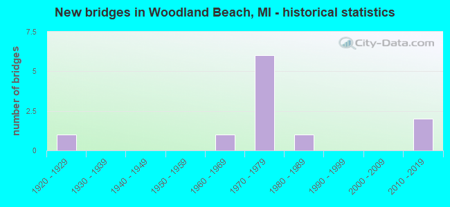
- New bridges - historical statistics
- 11920-1929
- 11960-1969
- 61970-1979
- 11980-1989
- 22010-2019

- Reconstructed bridges - Historical Statistics
- 11970-1979
- 01980-1989
- 01990-1999
- 22000-2009


- Bridge Condition - Deck
- 14.3%Very good
- 42.9%Good
- 28.6%Satisfactory
- 14.3%Fair

- Bridge Condition - Superstructure
- 28.6%Excellent
- 14.3%Very good
- 14.3%Good
- 28.6%Satisfactory
- 14.3%Fair

- Bridge Condition - Substructure
- 14.3%Very good
- 42.9%Good
- 14.3%Satisfactory
- 28.6%Fair

- Bridge Condition - Channel
- 40.0%Excellent
- 20.0%Very good
- 20.0%Good
- 20.0%Fair
Find on map >> Show street view
Structure Number: 7189, Location: 3.2 MI NE OF M-50 (Lat: 41.968839, Lng: -83.346378), Route carried "on" structure: Interstate 75, Year Built: 2015, Status: Open, Structure Length: 5.30m (17.39ft), Average Daily Traffic: 36,850 (year 2013), Truck Traffic: 18%, Average Future Daily Traffic: 40,375 (year 2035), Design Load: Greater than HL93, Features Intersected: STONY CREEK
Minimum Vertical Clearance: 30.48m (100.00ft), Kilometerpoint: 29.631, Lanes on structure: 4, Base Highway Network: Yes (Inventory Route: 122, Subroute: 10), Owner: State Highway Agency, Approaching Roadway Width: 21.8m (71.5ft), Material/Design: Prestressed concrete, Design/Construction: Box Beam or Girders - Single/Spread, Number Of Spans In Main Unit: 3, Length of Maximum Span: 26.0m (85.3ft), Curb-To-Curb Width: 22.4m (73.5ft), Out-to-Out Width: 23.4m (76.8ft)
Condition: Deck: Good, Superstructure: Excellent, Substructure: Good, Channel: Excellent, Operating Rating: 59.6 metric tons, Method Used To Determine Operating Rating: Load and Resistance Factor Rating (LRFR) rating reported by rating factor(RF) method using HL-93 loadings, Inventory Rating: 40.8 metric tons, Method Used To Determine Inventory Rating: Load and Resistance Factor Rating (LRFR) rating reported by rating factor(RF) method using HL-93 loadings, Structural Evaluation: Better than present minimum criteria, Deck Geometry: Superior to present desirable criteria, Waterway Adequacy: Equal to present desirable criteria, Approach Roadway Alignment: Equal to present desirable criteria, Designated Inspection Frequency: Every 24 months, Inspection Date: September 2020, Deck Structure Type: Concrete Cast-file-Place, Wearing Surface/Protective System: Wearing Surface: Monolithic Concrete, Deck Protection: Epoxy Coated Reinforcing
Find on map >> Show street view
Structure Number: 719, Location: 3.2 MI NE OF M-50 (Lat: 41.968961, Lng: -83.346667), Route carried "on" structure: Interstate 75, Year Built: 2016, Status: Open, Structure Length: 5.30m (17.39ft), Average Daily Traffic: 36,850 (year 2013), Truck Traffic: 18%, Average Future Daily Traffic: 40,375 (year 2035), Design Load: Greater than HL93, Features Intersected: STONY CREEK
Minimum Vertical Clearance: 30.48m (100.00ft), Kilometerpoint: 29.631, Lanes on structure: 4, Base Highway Network: Yes (Inventory Route: 122, Subroute: 9), Owner: State Highway Agency, Approaching Roadway Width: 21.8m (71.5ft), Material/Design: Prestressed concrete, Design/Construction: Box Beam or Girders - Single/Spread, Number Of Spans In Main Unit: 3, Length of Maximum Span: 26.0m (85.3ft), Curb-To-Curb Width: 21.8m (71.5ft), Out-to-Out Width: 22.8m (74.8ft)
Condition: Deck: Very good, Superstructure: Excellent, Substructure: Very good, Channel: Excellent, Operating Rating: 62.5 metric tons, Method Used To Determine Operating Rating: Load and Resistance Factor Rating (LRFR) rating reported by rating factor(RF) method using HL-93 loadings, Inventory Rating: 44.7 metric tons, Method Used To Determine Inventory Rating: Load and Resistance Factor Rating (LRFR) rating reported by rating factor(RF) method using HL-93 loadings, Structural Evaluation: Equal to present desirable criteria, Deck Geometry: Better than present minimum criteria, Waterway Adequacy: Equal to present desirable criteria, Approach Roadway Alignment: Equal to present desirable criteria, Designated Inspection Frequency: Every 24 months, Inspection Date: September 2020, Deck Structure Type: Concrete Cast-file-Place, Wearing Surface/Protective System: Wearing Surface: Monolithic Concrete, Deck Protection: Epoxy Coated Reinforcing
Find on map >> Show street view
Structure Number: 72, Location: 2.0 MI SW OF NEWPORT (Lat: 41.978825, Lng: -83.338039), Route carried "on" structure: County highway , Year Built: 1975, Status: Open, Structure Length: 10.13m (33.23ft), Average Daily Traffic: 270 (year 1995), Average Future Daily Traffic: 270 (year 2015), Design Load: H 20, Features Intersected: I-75, Facility Carried by Structure: POST RD
Minimum Vertical Clearance: 30.48m (100.00ft), Kilometerpoint: 1.160, Lanes on structure: 2, Lanes under structure: 9, Owner: State Highway Agency, Approaching Roadway Width: 12.2m (40.0ft), Skew: 3 degrees, Material/Design: Steel, Design/Construction: Stringer/Multi-beam, Number Of Spans In Main Unit: 4, Length of Maximum Span: 40.6m (133.2ft), Curb or Sidewalk Widths: Left: 0.2m (0.7ft), Right: 0.2m (0.7ft), Curb-To-Curb Width: 13.6m (44.6ft), Out-to-Out Width: 14.8m (48.6ft)
Condition: Deck: Satisfactory, Superstructure: Satisfactory, Substructure: Fair, Operating Rating: 74.2 metric tons, Method Used To Determine Operating Rating: Load Factor (LF) rating reported by rating factor (RF) method using MS18 loading, Inventory Rating: 41.1 metric tons, Method Used To Determine Inventory Rating: Load Factor (LF) rating reported by rating factor (RF) method using MS18 loading, Structural Evaluation: Somewhat better than minimum adequacy, Deck Geometry: Superior to present desirable criteria, Underclear: Somewhat better than minimum adequacy, Approach Roadway Alignment: Equal to present desirable criteria, Designated Inspection Frequency: Every 24 months, Inspection Date: May 2021, Deck Structure Type: Concrete Cast-file-Place, Wearing Surface/Protective System: Wearing Surface: Epoxy Overlay, Deck Protection: Epoxy Coated Reinforcing
Find on map >> Show street view
Structure Number: 7211, Location: 5 MI N OF MONROE (Lat: 41.986433, Lng: -83.331736), Route carried "on" structure: Interstate 275, Year Built: 1973, Year Reconstructed: 2011, Status: Open, Structure Length: 8.28m (27.17ft), Average Daily Traffic: 1,210 (year 2010), Truck Traffic: 22%, Average Future Daily Traffic: 1,525 (year 2040), Design Load: HS 20+Mod, Features Intersected: I-75
Minimum Vertical Clearance: 30.48m (100.00ft), Kilometerpoint: 1.275, Lanes on structure: 2, Lanes under structure: 8, Base Highway Network: Yes (Inventory Route: 122, Subroute: 2), Owner: State Highway Agency, Approaching Roadway Width: 11.5m (37.7ft), Skew: 2 degrees, Material/Design: Steel, Design/Construction: Stringer/Multi-beam, Number Of Spans In Main Unit: 4, Length of Maximum Span: 33.4m (109.6ft), Curb-To-Curb Width: 10.5m (34.4ft), Out-to-Out Width: 11.5m (37.7ft)
Condition: Deck: Good, Superstructure: Good, Substructure: Good, Operating Rating: 92.3 metric tons, Method Used To Determine Operating Rating: Load Factor (LF) rating reported by rating factor (RF) method using MS18 loading, Inventory Rating: 55.4 metric tons, Method Used To Determine Inventory Rating: Load Factor (LF) rating reported by rating factor (RF) method using MS18 loading, Structural Evaluation: Better than present minimum criteria, Deck Geometry: Meets minimum limits, Underclear: Somewhat better than minimum adequacy, Approach Roadway Alignment: Equal to present desirable criteria, Designated Inspection Frequency: Every 24 months, Inspection Date: July 2021, Deck Structure Type: Concrete Cast-file-Place, Wearing Surface/Protective System: Wearing Surface: Monolithic Concrete, Deck Protection: Epoxy Coated Reinforcing
Find on map >> Show street view
Structure Number: 7212, Location: 5 MI N OF MONROE (Lat: 41.992219, Lng: -83.326875), Route carried "on" structure: Ramp Interstate 275, Year Built: 1973, Status: Open, Structure Length: 10.84m (35.56ft), Average Daily Traffic: 15,020 (year 2007), Truck Traffic: 23%, Average Future Daily Traffic: 15,418 (year 2018), Design Load: HS 20, Features Intersected: I-75
Minimum Vertical Clearance: 30.48m (100.00ft), Kilometerpoint: 1.357, Lanes on structure: 2, Lanes under structure: 7, Owner: State Highway Agency, Approaching Roadway Width: 14.6m (47.9ft), Skew: 4 degrees, Material/Design: Steel, Design/Construction: Stringer/Multi-beam, Number Of Spans In Main Unit: 4, Length of Maximum Span: 39.6m (129.9ft), Curb-To-Curb Width: 12.6m (41.3ft), Out-to-Out Width: 13.6m (44.6ft)
Condition: Deck: Satisfactory, Superstructure: Satisfactory, Substructure: Satisfactory, Operating Rating: 68.7 metric tons, Method Used To Determine Operating Rating: Load Factor (LF), Inventory Rating: 41.1 metric tons, Method Used To Determine Inventory Rating: Load Factor (LF), Structural Evaluation: Equal to present minimum criteria, Deck Geometry: Superior to present desirable criteria, Underclear: High priority of corrective action, Approach Roadway Alignment: Equal to present minimum criteria, Designated Inspection Frequency: Every 24 months, Inspection Date: July 2021, Deck Structure Type: Concrete Cast-file-Place, Wearing Surface/Protective System: Wearing Surface: Epoxy Overlay
Find on map >> Show street view
Structure Number: 7274, Location: 0.1 MI N OF NADEAU RD (Lat: 41.963950, Lng: -83.339258), Route carried "on" structure: County highway , Year Built: 1929, Year Reconstructed: 1977, Status: Open, Structure Length: 3.02m (9.91ft), Average Daily Traffic: 1,047 (year 2017), Truck Traffic: 15%, Average Future Daily Traffic: 1,204 (year 2037), Design Load: HS 20, Features Intersected: STONY CREEK, Facility Carried by Structure: MENTEL RD
Minimum Vertical Clearance: 30.48m (100.00ft), Kilometerpoint: 3.314, Lanes on structure: 2, Owner: County Highway Agency, Approaching Roadway Width: 7.9m (25.9ft), Material/Design: Prestressed concrete, Design/Construction: Box Beam or Girders - Multiple, Number Of Spans In Main Unit: 2, Length of Maximum Span: 14.7m (48.2ft), Curb-To-Curb Width: 8.4m (27.6ft), Out-to-Out Width: 9.3m (30.5ft)
Condition: Deck: Fair, Superstructure: Fair, Substructure: Fair, Channel: Fair, Operating Rating: 75.2 metric tons, Method Used To Determine Operating Rating: Load Factor (LF) rating reported by rating factor (RF) method using MS18 loading, Inventory Rating: 45.0 metric tons, Method Used To Determine Inventory Rating: Load Factor (LF) rating reported by rating factor (RF) method using MS18 loading, Structural Evaluation: Somewhat better than minimum adequacy, Deck Geometry: Meets minimum limits, Waterway Adequacy: Equal to present desirable criteria, Approach Roadway Alignment: High priority of corrective action, Designated Inspection Frequency: Every 24 months, Inspection Date: November 2020, Deck Structure Type: Concrete Precast Panels, Wearing Surface/Protective System: Wearing Surface: Bituminous, Membrane: Preformed Fabric
Find on map >> Show street view
Structure Number: 7276, Location: 3.0 MI NE OF I-75 (Lat: 41.948700, Lng: -83.309639), Route carried "on" structure: County highway 2016, Year Built: 1966, Year Reconstructed: 2005, Status: Open, Structure Length: 3.66m (12.01ft), Average Daily Traffic: 9,388 (year 2017), Truck Traffic: 6%, Average Future Daily Traffic: 10,796 (year 2037), Design Load: HS 25 or greater, Features Intersected: STONY CREEK, Facility Carried by Structure: NORTH DIXIE HWY
Minimum Vertical Clearance: 16.18m (53.08ft), Kilometerpoint: 7.672, Lanes on structure: 3, Owner: County Highway Agency, Approaching Roadway Width: 14.9m (48.9ft), Skew: 3 degrees, Material/Design: Prestressed concrete, Design/Construction: Box Beam or Girders - Multiple, Number Of Spans In Main Unit: 3, Length of Maximum Span: 12.2m (40.0ft), Curb-To-Curb Width: 14.9m (48.9ft), Out-to-Out Width: 15.6m (51.2ft)
Condition: Deck: Good, Superstructure: Very good, Substructure: Good, Channel: Very good, Operating Rating: 80.0 metric tons, Method Used To Determine Operating Rating: Load Factor (LF) rating reported by rating factor (RF) method using MS18 loading, Inventory Rating: 48.0 metric tons, Method Used To Determine Inventory Rating: Load Factor (LF) rating reported by rating factor (RF) method using MS18 loading, Structural Evaluation: Better than present minimum criteria, Deck Geometry: Equal to present minimum criteria, Waterway Adequacy: Equal to present minimum criteria, Approach Roadway Alignment: Equal to present minimum criteria, Designated Inspection Frequency: Every 24 months, Inspection Date: November 2021, Deck Structure Type: Concrete Cast-file-Place, Wearing Surface/Protective System: Wearing Surface: Monolithic Concrete, Deck Protection: Epoxy Coated Reinforcing
Find on map >> Show street view
Structure Number: 7277, Location: 3.55 MI N OF I-75 (Lat: 41.953469, Lng: -83.302061), Route carried "on" structure: County highway 2016, Year Built: 1988, Status: Open, Structure Length: 0.79m (2.59ft), Average Daily Traffic: 8,479 (year 2006), Truck Traffic: 10%, Average Future Daily Traffic: 9,200 (year 2026), Design Load: HS 20, Features Intersected: WALKER DRAIN, Facility Carried by Structure: NORTH DIXIE HWY
Minimum Vertical Clearance: 30.48m (100.00ft), Kilometerpoint: 8.493, Lanes on structure: 2, Owner: County Highway Agency, Approaching Roadway Width: 10.4m (34.1ft), Material/Design: Concrete, Design/Construction: Culvert, Number Of Spans In Main Unit: 2, Length of Maximum Span: 3.4m (11.2ft), Curb-To-Curb Width: 10.4m (34.1ft), Out-to-Out Width: 17.7m (58.1ft)
Condition: Channel: Good, Culverts: Satisfactory, Operating Rating: 54.1 metric tons, Method Used To Determine Operating Rating: Load Factor (LF) rating reported by rating factor (RF) method using MS18 loading, Inventory Rating: 32.4 metric tons, Method Used To Determine Inventory Rating: Load Factor (LF) rating reported by rating factor (RF) method using MS18 loading, Structural Evaluation: Equal to present minimum criteria, Deck Geometry: Meets minimum limits, Waterway Adequacy: Equal to present desirable criteria, Approach Roadway Alignment: Equal to present minimum criteria, Designated Inspection Frequency: Every 24 months, Inspection Date: November 2020
Find on map >> Show street view
Structure Number: 72, Location: 2.0 MI SW OF NEWPORT (Lat: 41.978825, Lng: -83.338039), Route carried "under" structure: Interstate 75, Year Built: 1975, Structure Length: 0. m, Average Daily Traffic: 72,986 (year 2007), Truck Traffic: 20%, Features Intersected: I-75, Facility Carried by Structure: POST RD
Minimum Vertical Clearance: 5.18m (16.99ft), Kilometerpoint: 30.936, Lanes on structure: 2, Lanes under structure: 9, Material/Design: Steel, Design/Construction: Stringer/Multi-beam, Length of Maximum Span: 40.6m (133.2ft)
Find on map >> Show street view
Structure Number: 7211, Location: 5 MI N OF MONROE (Lat: 41.986433, Lng: -83.331736), Route carried "under" structure: Interstate 75, Year Built: 1973, Structure Length: 0. m, Average Daily Traffic: 72,986 (year 2007), Truck Traffic: 33%, Features Intersected: I-75
Minimum Vertical Clearance: 5.18m (16.99ft), Kilometerpoint: 31.929, Lanes on structure: 2, Lanes under structure: 8, Material/Design: Steel, Design/Construction: Stringer/Multi-beam, Length of Maximum Span: 33.4m (109.6ft)
Find on map >> Show street view
Structure Number: 7212, Location: 5 MI N OF MONROE (Lat: 41.992219, Lng: -83.326875), Route carried "under" structure: Interstate 75, Year Built: 1973, Structure Length: 0. m, Average Daily Traffic: 49,344 (year 2007), Truck Traffic: 33%, Features Intersected: I-75
Minimum Vertical Clearance: 4.62m (15.16ft), Kilometerpoint: 32.687, Lanes on structure: 2, Lanes under structure: 7, Material/Design: Steel, Design/Construction: Stringer/Multi-beam, Length of Maximum Span: 39.6m (129.9ft)