Bridge Statistics for Woodhull, Illinois (IL)
Condition, Traffic, Stress, Structural Evaluation, Project Costs
- National Bridge Inventory (NBI) Statistics
- 32Number of bridges
- 240ft / 72.9mTotal length
- $1,168,000Total costs
- 98,470Total average daily traffic
- 30,620Total average daily truck traffic
- National Bridge Inventory (NBI) Registered Bridges for Woodhull
- No street view available for this location
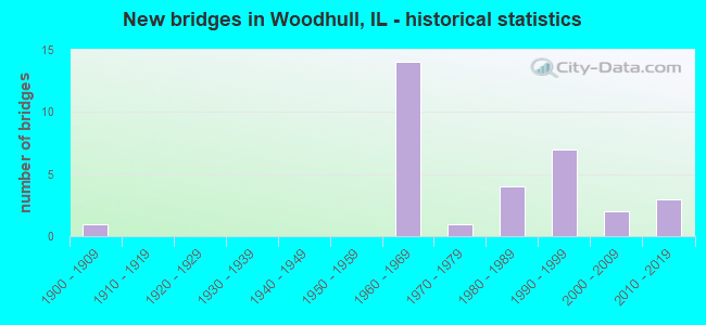
- New bridges - historical statistics
- 11900-1909
- 141960-1969
- 11970-1979
- 41980-1989
- 71990-1999
- 22000-2009
- 32010-2019


- Bridge Condition - Deck
- 39.1%Very good
- 26.1%Good
- 17.4%Satisfactory
- 8.7%Fair
- 8.7%Poor

- Bridge Condition - Superstructure
- 47.8%Very good
- 21.7%Good
- 13.0%Satisfactory
- 8.7%Fair
- 8.7%Serious

- Bridge Condition - Substructure
- 69.6%Very good
- 8.7%Good
- 13.0%Satisfactory
- 4.3%Fair
- 4.3%Poor

- Bridge Condition - Channel
- 10.0%Excellent
- 40.0%Very good
- 35.0%Good
- 5.0%Satisfactory
- 10.0%Fair

- Bridge Condition - Culverts
- 33.3%Very good
- 33.3%Satisfactory
- 33.3%Fair
Find on map >> Show street view
Structure Number: 370017, Location: 1 MI N JCT ILL 17 (Lat: 41.194967, Lng: -90.333206), Route carried "on" structure: Interstate 74, Year Built: 1967, Year Reconstructed: 2009, Status: Open, Structure Length: 4.19m (13.75ft), Average Daily Traffic: 7,500 (year 2021), Truck Traffic: 32%, Average Future Daily Traffic: 7,358 (year 2040), Design Load: HS 20+Mod, Features Intersected: TR 379B
Minimum Vertical Clearance: 30+ m (98+ ft), Kilometerpoint: 52.560, Lanes on structure: 2, Lanes under structure: 2, Base Highway Network: Yes, Owner: State Highway Agency, Approaching Roadway Width: 12.8m (42.0ft), Material/Design: Steel continuous, Design/Construction: Stringer/Multi-beam, Number Of Spans In Main Unit: 3, Length of Maximum Span: 14.8m (48.6ft), Curb-To-Curb Width: 12.8m (42.0ft), Out-to-Out Width: 13.8m (45.3ft)
Condition: Deck: Fair, Superstructure: Satisfactory, Substructure: Very good, Operating Rating: 72.9 metric tons, Method Used To Determine Operating Rating: Load Factor (LF) rating reported by rating factor (RF) method using MS18 loading, Inventory Rating: 43.7 metric tons, Method Used To Determine Inventory Rating: Load Factor (LF) rating reported by rating factor (RF) method using MS18 loading, Structural Evaluation: Equal to present minimum criteria, Deck Geometry: Equal to present desirable criteria, Underclear: Superior to present desirable criteria, Approach Roadway Alignment: Equal to present desirable criteria, Length Of Structure Improvement: 4.11m (13.48ft), Designated Inspection Frequency: Every 24 months, Inspection Date: October 2020, Bridge Improvement Cost: $389,000, Roadway Improvement Cost: $39,000, Total Project Cost: $584,000, Deck Structure Type: Concrete Cast-file-Place, Wearing Surface/Protective System: Deck Protection: Epoxy Coated Reinforcing
Find on map >> Show street view
Structure Number: 370018, Location: 1 MI N JCT ILL 17 (Lat: 41.194819, Lng: -90.333189), Route carried "on" structure: Interstate 74, Year Built: 1967, Year Reconstructed: 2009, Status: Open, Structure Length: 4.18m (13.71ft), Average Daily Traffic: 7,500 (year 2021), Truck Traffic: 32%, Average Future Daily Traffic: 9,000 (year 2040), Design Load: HS 20+Mod, Features Intersected: TR 379B
Minimum Vertical Clearance: 30+ m (98+ ft), Kilometerpoint: 52.576, Lanes on structure: 2, Lanes under structure: 2, Base Highway Network: Yes, Owner: State Highway Agency, Approaching Roadway Width: 12.8m (42.0ft), Material/Design: Steel continuous, Design/Construction: Stringer/Multi-beam, Number Of Spans In Main Unit: 3, Length of Maximum Span: 14.8m (48.6ft), Curb-To-Curb Width: 12.8m (42.0ft), Out-to-Out Width: 13.8m (45.3ft)
Condition: Deck: Satisfactory, Superstructure: Satisfactory, Substructure: Very good, Operating Rating: 73.2 metric tons, Method Used To Determine Operating Rating: Load Factor (LF) rating reported by rating factor (RF) method using MS18 loading, Inventory Rating: 44.1 metric tons, Method Used To Determine Inventory Rating: Load Factor (LF) rating reported by rating factor (RF) method using MS18 loading, Structural Evaluation: Equal to present minimum criteria, Deck Geometry: Equal to present desirable criteria, Underclear: Superior to present desirable criteria, Approach Roadway Alignment: Equal to present desirable criteria, Length Of Structure Improvement: 4.11m (13.48ft), Designated Inspection Frequency: Every 24 months, Inspection Date: October 2020, Bridge Improvement Cost: $389,000, Roadway Improvement Cost: $39,000, Total Project Cost: $584,000, Deck Structure Type: Concrete Cast-file-Place, Wearing Surface/Protective System: Deck Protection: Epoxy Coated Reinforcing
Find on map >> Show street view
Structure Number: 370019, Location: 0.5 MI W OF WOODHULL (Lat: 41.180558, Lng: -90.332567), Route carried "on" structure: Interstate 74, Year Built: 1967, Status: Open, Structure Length: 7.56m (24.80ft), Average Daily Traffic: 7,500 (year 2021), Truck Traffic: 32%, Average Future Daily Traffic: 7,358 (year 2032), Design Load: HS 20+Mod, Features Intersected: IL 17 & BNSF-EXEMPT
Minimum Vertical Clearance: 30+ m (98+ ft), Kilometerpoint: 54.137, Lanes on structure: 2, Lanes under structure: 2, Base Highway Network: Yes, Owner: State Highway Agency, Approaching Roadway Width: 13.4m (44.0ft), Skew: 1 degrees, Material/Design: Steel continuous, Design/Construction: Stringer/Multi-beam, Number Of Spans In Main Unit: 4, Length of Maximum Span: 20.7m (67.9ft), Curb-To-Curb Width: 11.9m (39.0ft), Out-to-Out Width: 12.9m (42.3ft)
Condition: Deck: Poor, Superstructure: Serious, Substructure: Fair, Operating Rating: 88.5 metric tons, Method Used To Determine Operating Rating: Load Factor (LF) rating reported by rating factor (RF) method using MS18 loading, Inventory Rating: 51.8 metric tons, Method Used To Determine Inventory Rating: Load Factor (LF) rating reported by rating factor (RF) method using MS18 loading, Structural Evaluation: High priority of corrective action, Deck Geometry: Equal to present minimum criteria, Underclear: Meets minimum limits, Approach Roadway Alignment: Equal to present minimum criteria, Designated Inspection Frequency: Every 12 months, Inspection Date: September 2021, Deck Structure Type: Concrete Cast-file-Place, Wearing Surface/Protective System: Deck Protection: Epoxy Coated Reinforcing
Find on map >> Show street view
Structure Number: 37002, Location: 0.5 MI W OF WOODHULL (Lat: 41.180411, Lng: -90.332569), Route carried "on" structure: Interstate 74, Year Built: 1967, Status: Open, Structure Length: 7.56m (24.80ft), Average Daily Traffic: 7,500 (year 2021), Truck Traffic: 32%, Average Future Daily Traffic: 7,256 (year 2032), Design Load: HS 20+Mod, Features Intersected: IL 17 & BNSF-EXEMPT
Minimum Vertical Clearance: 30+ m (98+ ft), Kilometerpoint: 54.153, Lanes on structure: 2, Lanes under structure: 2, Base Highway Network: Yes, Owner: State Highway Agency, Approaching Roadway Width: 13.4m (44.0ft), Skew: 1 degrees, Material/Design: Steel continuous, Design/Construction: Stringer/Multi-beam, Number Of Spans In Main Unit: 4, Length of Maximum Span: 20.7m (67.9ft), Curb-To-Curb Width: 13.9m (45.6ft), Out-to-Out Width: 14.9m (48.9ft)
Condition: Deck: Poor, Superstructure: Serious, Substructure: Poor, Operating Rating: 64.2 metric tons, Method Used To Determine Operating Rating: Load Factor (LF) rating reported by rating factor (RF) method using MS18 loading, Inventory Rating: 34.3 metric tons, Method Used To Determine Inventory Rating: Load Factor (LF) rating reported by rating factor (RF) method using MS18 loading, Structural Evaluation: High priority of corrective action, Deck Geometry: Superior to present desirable criteria, Underclear: Meets minimum limits, Approach Roadway Alignment: Equal to present minimum criteria, Designated Inspection Frequency: Every 12 months, Other Special Inspection Frequency: Every 12 months, Inspection Date: September 2021, Other Special Inspection Date: September 2021, Deck Structure Type: Concrete Cast-file-Place, Wearing Surface/Protective System: Wearing Surface: Bituminous, Membrane: Built-up
Find on map >> Show street view
Structure Number: 370105, Location: 1 MI SW OF WOODHULL (Lat: 41.165700, Lng: -90.332781), Route carried "on" structure: County highway , Year Built: 1965, Status: Open, Structure Length: 6.80m (22.31ft), Average Daily Traffic: 75 (year 2010), Truck Traffic: 13%, Average Future Daily Traffic: 77 (year 2032), Design Load: HS 15, Features Intersected: I-74, Facility Carried by Structure: TR 399-100N
Minimum Vertical Clearance: 30+ m (98+ ft), Kilometerpoint: 2.350, Lanes on structure: 2, Lanes under structure: 4, Owner: State Highway Agency, Approaching Roadway Width: 7.3m (24.0ft), Material/Design: Steel continuous, Design/Construction: Stringer/Multi-beam, Number Of Spans In Main Unit: 4, Length of Maximum Span: 20.4m (66.9ft), Curb or Sidewalk Widths: Left: 0.6m (2.0ft), Right: 0.6m (2.0ft), Curb-To-Curb Width: 7.3m (24.0ft), Out-to-Out Width: 9.1m (29.9ft)
Condition: Deck: Fair, Superstructure: Fair, Substructure: Good, Operating Rating: 55.1 metric tons, Method Used To Determine Operating Rating: Load Factor (LF) rating reported by rating factor (RF) method using MS18 loading, Inventory Rating: 32.1 metric tons, Method Used To Determine Inventory Rating: Load Factor (LF) rating reported by rating factor (RF) method using MS18 loading, Structural Evaluation: Somewhat better than minimum adequacy, Deck Geometry: Equal to present minimum criteria, Underclear: Meets minimum limits, Approach Roadway Alignment: Equal to present minimum criteria, Designated Inspection Frequency: Every 24 months, Inspection Date: November 2020, Deck Structure Type: Concrete Cast-file-Place
Find on map >> Show street view
Structure Number: 37201, Location: .1M N KNOX CO LINE (Lat: 41.152222, Lng: -90.331214), Route carried "on" structure: Interstate 74, Year Built: 1967, Status: Open, Structure Length: 0.70m (2.30ft), Average Daily Traffic: 15,000 (year 2021), Truck Traffic: 32%, Average Future Daily Traffic: 14,512 (year 2032), Design Load: HS 20, Features Intersected: STREAM
Minimum Vertical Clearance: 30+ m (98+ ft), Kilometerpoint: 57.372, Lanes on structure: 4, Base Highway Network: Yes, Owner: State Highway Agency, Approaching Roadway Width: 25.6m (84.0ft), Skew: 10 degrees, Material/Design: Steel, Design/Construction: Culvert, Number Of Spans In Main Unit: 2, Length of Maximum Span: 3.0m (9.8ft)
Condition: Channel: Good, Culverts: Satisfactory, Operating Rating: 88.8 metric tons, Method Used To Determine Operating Rating: Load Factor (LF) rating reported by rating factor (RF) method using MS18 loading, Inventory Rating: 88.8 metric tons, Method Used To Determine Inventory Rating: Load Factor (LF) rating reported by rating factor (RF) method using MS18 loading, Structural Evaluation: Equal to present minimum criteria, Waterway Adequacy: Equal to present desirable criteria, Approach Roadway Alignment: Equal to present desirable criteria, Designated Inspection Frequency: Every 24 months, Inspection Date: September 2020
Find on map >> Show street view
Structure Number: 373278, Location: 3.5 MI. NE WOODHULL (Lat: 41.187336, Lng: -90.247200), Route carried "on" structure: County highway , Year Built: 1988, Status: Open, Structure Length: 1.83m (6.00ft), Average Daily Traffic: 25 (year 2020), Average Future Daily Traffic: 25 (year 2040), Design Load: HS 20, Features Intersected: DUGOUT CREEK, Facility Carried by Structure: TR 124
Minimum Vertical Clearance: 30+ m (98+ ft), Kilometerpoint: 4.651, Lanes on structure: 2, Owner: Town or Township Highway Agency, Approaching Roadway Width: 7.3m (24.0ft), Material/Design: Prestressed concrete, Design/Construction: Box Beam or Girders - Multiple, Number Of Spans In Main Unit: 1, Length of Maximum Span: 18.0m (59.1ft), Curb-To-Curb Width: 7.3m (24.0ft), Out-to-Out Width: 7.3m (24.0ft)
Condition: Deck: Very good, Superstructure: Very good, Substructure: Very good, Channel: Very good, Operating Rating: 44.4 metric tons, Method Used To Determine Operating Rating: Assigned rating based on Load Factor Design (LFD) reported by rating factor (RF) using MS18 loading, Inventory Rating: 32.4 metric tons, Method Used To Determine Inventory Rating: Assigned rating based on Load Factor Design (LFD) reported by rating factor (RF) using MS18 loading, Structural Evaluation: Equal to present desirable criteria, Deck Geometry: Equal to present minimum criteria, Waterway Adequacy: Equal to present desirable criteria, Approach Roadway Alignment: Equal to present desirable criteria, Designated Inspection Frequency: Every 48 months, Inspection Date: August 2019, Deck Structure Type: Concrete Precast Panels
Find on map >> Show street view
Structure Number: 373279, Location: 3MIE OF WOODHULL (Lat: 41.177933, Lng: -90.247408), Route carried "on" structure: County highway , Year Built: 1990, Status: Open, Structure Length: 1.15m (3.77ft), Average Daily Traffic: 25 (year 2020), Average Future Daily Traffic: 25 (year 2040), Design Load: HS 20, Features Intersected: BRANCH DUGOUT CREEK, Facility Carried by Structure: TR 124 (1000 E)
Minimum Vertical Clearance: 30+ m (98+ ft), Kilometerpoint: 5.697, Lanes on structure: 2, Owner: Town or Township Highway Agency, Approaching Roadway Width: 7.3m (24.0ft), Material/Design: Concrete, Design/Construction: Channel Beam, Number Of Spans In Main Unit: 1, Length of Maximum Span: 10.7m (35.1ft), Curb-To-Curb Width: 8.0m (26.2ft), Out-to-Out Width: 8.0m (26.2ft)
Condition: Deck: Very good, Superstructure: Very good, Substructure: Very good, Channel: Very good, Operating Rating: 44.4 metric tons, Method Used To Determine Operating Rating: Assigned rating based on Load Factor Design (LFD) reported by rating factor (RF) using MS18 loading, Inventory Rating: 32.4 metric tons, Method Used To Determine Inventory Rating: Assigned rating based on Load Factor Design (LFD) reported by rating factor (RF) using MS18 loading, Structural Evaluation: Equal to present desirable criteria, Deck Geometry: Equal to present minimum criteria, Waterway Adequacy: Equal to present desirable criteria, Approach Roadway Alignment: Equal to present desirable criteria, Designated Inspection Frequency: Every 48 months, Inspection Date: August 2019, Deck Structure Type: Concrete Precast Panels
Find on map >> Show street view
Structure Number: 373331, Location: 2.5 MI. SW WOODHULL (Lat: 41.165689, Lng: -90.350231), Route carried "on" structure: County highway , Year Built: 1996, Status: Open, Structure Length: 1.26m (4.13ft), Average Daily Traffic: 50 (year 2020), Truck Traffic: 20%, Average Future Daily Traffic: 50 (year 2040), Design Load: HS 20, Features Intersected: BR. OF PAGE CREEK, Facility Carried by Structure: TR 399
Minimum Vertical Clearance: 30+ m (98+ ft), Kilometerpoint: 0.949, Lanes on structure: 2, Owner: Town or Township Highway Agency, Approaching Roadway Width: 7.3m (24.0ft), Skew: 1 degrees, Material/Design: Prestressed concrete, Design/Construction: Box Beam or Girders - Multiple, Number Of Spans In Main Unit: 1, Length of Maximum Span: 11.9m (39.0ft), Curb-To-Curb Width: 7.3m (24.0ft), Out-to-Out Width: 7.3m (24.0ft)
Condition: Deck: Very good, Superstructure: Very good, Substructure: Very good, Channel: Excellent, Operating Rating: 44.1 metric tons, Method Used To Determine Operating Rating: Assigned rating based on Load Factor Design (LFD) reported by rating factor (RF) using MS18 loading, Inventory Rating: 32.4 metric tons, Method Used To Determine Inventory Rating: Assigned rating based on Load Factor Design (LFD) reported by rating factor (RF) using MS18 loading, Structural Evaluation: Equal to present desirable criteria, Deck Geometry: Equal to present minimum criteria, Waterway Adequacy: Superior to present desirable criteria, Approach Roadway Alignment: Equal to present desirable criteria, Designated Inspection Frequency: Every 48 months, Inspection Date: August 2019, Deck Structure Type: Concrete Precast Panels
Find on map >> Show street view
Structure Number: 373335, Location: 4 MI. NE. OF ALPHA (Lat: 41.221375, Lng: -90.341108), Route carried "on" structure: County highway , Year Built: 1998, Status: Open, Structure Length: 1.87m (6.14ft), Average Daily Traffic: 125 (year 2020), Truck Traffic: 16%, Average Future Daily Traffic: 900 (year 2040), Design Load: HS 20, Features Intersected: MUD CREEK, Facility Carried by Structure: TR 54
Minimum Vertical Clearance: 30+ m (98+ ft), Kilometerpoint: 1.786, Lanes on structure: 2, Owner: Town or Township Highway Agency, Approaching Roadway Width: 4.9m (16.1ft), Material/Design: Prestressed concrete, Design/Construction: Box Beam or Girders - Multiple, Number Of Spans In Main Unit: 1, Length of Maximum Span: 18.0m (59.1ft), Curb-To-Curb Width: 7.3m (24.0ft), Out-to-Out Width: 7.3m (24.0ft)
Condition: Deck: Very good, Superstructure: Very good, Substructure: Very good, Channel: Very good, Operating Rating: 44.1 metric tons, Method Used To Determine Operating Rating: Assigned rating based on Load Factor Design (LFD) reported by rating factor (RF) using MS18 loading, Inventory Rating: 32.4 metric tons, Method Used To Determine Inventory Rating: Assigned rating based on Load Factor Design (LFD) reported by rating factor (RF) using MS18 loading, Structural Evaluation: Equal to present desirable criteria, Deck Geometry: Somewhat better than minimum adequacy, Waterway Adequacy: Equal to present desirable criteria, Approach Roadway Alignment: Equal to present desirable criteria, Designated Inspection Frequency: Every 48 months, Inspection Date: January 2020, Deck Structure Type: Concrete Precast Panels
Find on map >> Show street view
Structure Number: 373336, Location: 2 MI. NW WOODHULL (Lat: 41.209106, Lng: -90.341425), Route carried "on" structure: County highway , Year Built: 1999, Status: Open, Structure Length: 1.72m (5.64ft), Average Daily Traffic: 125 (year 2020), Truck Traffic: 16%, Average Future Daily Traffic: 900 (year 2040), Design Load: HS 20, Features Intersected: MUD CREEK, Facility Carried by Structure: TR 54
Minimum Vertical Clearance: 30+ m (98+ ft), Kilometerpoint: 3.154, Lanes on structure: 2, Owner: Town or Township Highway Agency, Approaching Roadway Width: 4.9m (16.1ft), Skew: 1 degrees, Material/Design: Prestressed concrete, Design/Construction: Box Beam or Girders - Multiple, Number Of Spans In Main Unit: 1, Length of Maximum Span: 16.5m (54.1ft), Curb-To-Curb Width: 7.3m (24.0ft), Out-to-Out Width: 7.3m (24.0ft)
Condition: Deck: Very good, Superstructure: Very good, Substructure: Very good, Channel: Excellent, Operating Rating: 44.1 metric tons, Method Used To Determine Operating Rating: Assigned rating based on Load Factor Design (LFD) reported by rating factor (RF) using MS18 loading, Inventory Rating: 32.4 metric tons, Method Used To Determine Inventory Rating: Assigned rating based on Load Factor Design (LFD) reported by rating factor (RF) using MS18 loading, Structural Evaluation: Equal to present desirable criteria, Deck Geometry: Somewhat better than minimum adequacy, Waterway Adequacy: Superior to present desirable criteria, Approach Roadway Alignment: Equal to present desirable criteria, Designated Inspection Frequency: Every 48 months, Inspection Date: August 2019, Deck Structure Type: Concrete Precast Panels
Find on map >> Show street view
Structure Number: 373355, Location: 4.0 MI SE ALPHA (Lat: 41.161694, Lng: -90.342258), Route carried "on" structure: County highway , Year Built: 2005, Status: Open, Structure Length: 0.98m (3.22ft), Average Daily Traffic: 100 (year 2020), Truck Traffic: 24%, Average Future Daily Traffic: 500 (year 2040), Design Load: HS 20, Features Intersected: UNNAMED CREEK, Facility Carried by Structure: TR 54
Minimum Vertical Clearance: 30+ m (98+ ft), Kilometerpoint: 2.044, Lanes on structure: 2, Owner: Town or Township Highway Agency, Approaching Roadway Width: 7.9m (25.9ft), Material/Design: Concrete, Design/Construction: Culvert, Number Of Spans In Main Unit: 1, Length of Maximum Span: 6.7m (22.0ft)
Condition: Channel: Very good, Culverts: Very good, Operating Rating: 44.1 metric tons, Method Used To Determine Operating Rating: Assigned rating based on Load Factor Design (LFD) reported by rating factor (RF) using MS18 loading, Inventory Rating: 32.4 metric tons, Method Used To Determine Inventory Rating: Assigned rating based on Load Factor Design (LFD) reported by rating factor (RF) using MS18 loading, Structural Evaluation: Equal to present desirable criteria, Waterway Adequacy: Superior to present desirable criteria, Approach Roadway Alignment: Equal to present desirable criteria, Designated Inspection Frequency: Every 48 months, Inspection Date: August 2019
Find on map >> Show street view
Structure Number: 373374, Location: 2 MI NE WOODHULL (Lat: 41.195797, Lng: -90.287806), Route carried "on" structure: County highway , Year Built: 2013, Status: Open, Structure Length: 1.44m (4.72ft), Average Daily Traffic: 75 (year 2010), Truck Traffic: 13%, Average Future Daily Traffic: 80 (year 2035), Design Load: HS 25 or greater, Features Intersected: DUGOUT CREEK, Facility Carried by Structure: TR 379
Minimum Vertical Clearance: 30+ m (98+ ft), Kilometerpoint: 2.897, Lanes on structure: 2, Owner: Town or Township Highway Agency, Approaching Roadway Width: 7.3m (24.0ft), Skew: 3 degrees, Material/Design: Prestressed concrete, Design/Construction: Box Beam or Girders - Multiple, Number Of Spans In Main Unit: 1, Length of Maximum Span: 13.5m (44.3ft), Curb-To-Curb Width: 7.3m (24.0ft), Out-to-Out Width: 7.3m (24.0ft)
Condition: Deck: Very good, Superstructure: Very good, Substructure: Very good, Channel: Very good, Operating Rating: 42.1 metric tons, Method Used To Determine Operating Rating: Assigned ratings based on Load and Resistance Factor Design (LRFD) reported by rating factor (RF) using HL93 loadings, Inventory Rating: 32.4 metric tons, Method Used To Determine Inventory Rating: Assigned ratings based on Load and Resistance Factor Design (LRFD) reported by rating factor (RF) using HL93 loadings, Structural Evaluation: Equal to present desirable criteria, Deck Geometry: Equal to present minimum criteria, Waterway Adequacy: Superior to present desirable criteria, Approach Roadway Alignment: Equal to present desirable criteria, Designated Inspection Frequency: Every 48 months, Inspection Date: August 2019, Deck Structure Type: Concrete Precast Panels
Find on map >> Show street view
Structure Number: 480063, Location: 4 MI SW OF WOODHULL (Lat: 41.122250, Lng: -90.333339), Route carried "on" structure: County highway , Year Built: 1965, Status: Open, Structure Length: 6.80m (22.31ft), Average Daily Traffic: 50 (year 2017), Average Future Daily Traffic: 50 (year 2032), Design Load: HS 15, Features Intersected: I-74, Facility Carried by Structure: TR 21
Minimum Vertical Clearance: 30+ m (98+ ft), Kilometerpoint: 5.552, Lanes on structure: 2, Lanes under structure: 4, Owner: State Highway Agency, Approaching Roadway Width: 9.1m (29.9ft), Material/Design: Steel continuous, Design/Construction: Stringer/Multi-beam, Number Of Spans In Main Unit: 4, Length of Maximum Span: 20.4m (66.9ft), Curb or Sidewalk Widths: Left: 0.6m (2.0ft), Right: 0.6m (2.0ft), Curb-To-Curb Width: 7.3m (24.0ft), Out-to-Out Width: 9.1m (29.9ft)
Condition: Deck: Good, Superstructure: Fair, Substructure: Satisfactory, Operating Rating: 45.7 metric tons, Method Used To Determine Operating Rating: Load Factor (LF) rating reported by rating factor (RF) method using MS18 loading, Inventory Rating: 27.2 metric tons, Method Used To Determine Inventory Rating: Load Factor (LF) rating reported by rating factor (RF) method using MS18 loading, Structural Evaluation: Somewhat better than minimum adequacy, Deck Geometry: Equal to present minimum criteria, Underclear: Meets minimum limits, Approach Roadway Alignment: Equal to present minimum criteria, Designated Inspection Frequency: Every 24 months, Inspection Date: Febuary 2020, Deck Structure Type: Concrete Cast-file-Place
Find on map >> Show street view
Structure Number: 480104, Location: 0.9mi S Henry Co Ln (Lat: 41.138158, Lng: -90.333867), Route carried "on" structure: Interstate 74, Year Built: 2018, Status: Open, Structure Length: 4.01m (13.16ft), Average Daily Traffic: 7,500 (year 2021), Truck Traffic: 32%, Average Future Daily Traffic: 7,114 (year 2032), Design Load: HS 25 or greater, Features Intersected: Pope Creek
Minimum Vertical Clearance: 30+ m (98+ ft), Kilometerpoint: 58.949, Lanes on structure: 2, Base Highway Network: Yes, Owner: State Highway Agency, Approaching Roadway Width: 12.2m (40.0ft), Material/Design: Steel continuous, Design/Construction: Stringer/Multi-beam, Number Of Spans In Main Unit: 2, Length of Maximum Span: 22.3m (73.2ft), Curb-To-Curb Width: 12.2m (40.0ft), Out-to-Out Width: 13.2m (43.3ft)
Condition: Deck: Satisfactory, Superstructure: Very good, Substructure: Very good, Channel: Very good, Operating Rating: 82.3 metric tons, Method Used To Determine Operating Rating: Load and Resistance Factor Rating (LRFR) rating reported by rating factor(RF) method using HL-93 loadings, Inventory Rating: 63.5 metric tons, Method Used To Determine Inventory Rating: Load and Resistance Factor Rating (LRFR) rating reported by rating factor(RF) method using HL-93 loadings, Structural Evaluation: Equal to present desirable criteria, Deck Geometry: Better than present minimum criteria, Waterway Adequacy: Superior to present desirable criteria, Approach Roadway Alignment: Equal to present desirable criteria, Designated Inspection Frequency: Every 24 months, Inspection Date: January 2021, Deck Structure Type: Concrete Cast-file-Place, Wearing Surface/Protective System: Deck Protection: Epoxy Coated Reinforcing
Find on map >> Show street view
Structure Number: 480105, Location: 1 mi s Henry Co line (Lat: 41.138017, Lng: -90.333908), Route carried "on" structure: Interstate 74, Year Built: 2018, Status: Open, Structure Length: 3.49m (11.45ft), Average Daily Traffic: 7,500 (year 2021), Truck Traffic: 32%, Average Future Daily Traffic: 7,114 (year 2032), Design Load: HS 25 or greater, Features Intersected: Pope Creek
Minimum Vertical Clearance: 30+ m (98+ ft), Kilometerpoint: 58.965, Lanes on structure: 2, Base Highway Network: Yes, Owner: State Highway Agency, Approaching Roadway Width: 12.2m (40.0ft), Skew: 2 degrees, Material/Design: Prestressed concrete, Design/Construction: Stringer/Multi-beam, Number Of Spans In Main Unit: 1, Length of Maximum Span: 33.6m (110.2ft), Curb-To-Curb Width: 12.2m (40.0ft), Out-to-Out Width: 13.2m (43.3ft)
Condition: Deck: Satisfactory, Superstructure: Very good, Substructure: Very good, Channel: Very good, Operating Rating: 51.5 metric tons, Method Used To Determine Operating Rating: Load and Resistance Factor Rating (LRFR) rating reported by rating factor(RF) method using HL-93 loadings, Inventory Rating: 40.5 metric tons, Method Used To Determine Inventory Rating: Load and Resistance Factor Rating (LRFR) rating reported by rating factor(RF) method using HL-93 loadings, Structural Evaluation: Equal to present desirable criteria, Deck Geometry: Better than present minimum criteria, Waterway Adequacy: Superior to present desirable criteria, Approach Roadway Alignment: Equal to present desirable criteria, Designated Inspection Frequency: Every 24 months, Inspection Date: January 2021, Deck Structure Type: Concrete Cast-file-Place, Wearing Surface/Protective System: Deck Protection: Epoxy Coated Reinforcing
Find on map >> Show street view
Structure Number: 483061, Location: NE-17-T13NR2E (Lat: 41.122908, Lng: -90.291836), Route carried "on" structure: County highway , Year Built: 1966, Status: Open, Structure Length: 0.73m (2.40ft), Average Daily Traffic: 10 (year 2017), Average Future Daily Traffic: 10 (year 2032), Design Load: HS 15, Features Intersected: TRIB TO POPE CREEK, Facility Carried by Structure: TR 21A
Minimum Vertical Clearance: 30+ m (98+ ft), Kilometerpoint: 2.655, Lanes on structure: 2, Owner: Town or Township Highway Agency, Approaching Roadway Width: 8.5m (27.9ft), Material/Design: Concrete, Design/Construction: Channel Beam, Number Of Spans In Main Unit: 1, Length of Maximum Span: 7.0m (23.0ft), Curb-To-Curb Width: 6.2m (20.3ft), Out-to-Out Width: 6.8m (22.3ft)
Condition: Deck: Satisfactory, Superstructure: Satisfactory, Substructure: Satisfactory, Channel: Satisfactory, Operating Rating: 52.2 metric tons, Method Used To Determine Operating Rating: Load Factor (LF) rating reported by rating factor (RF) method using MS18 loading, Inventory Rating: 31.4 metric tons, Method Used To Determine Inventory Rating: Load Factor (LF) rating reported by rating factor (RF) method using MS18 loading, Structural Evaluation: Equal to present minimum criteria, Deck Geometry: Somewhat better than minimum adequacy, Waterway Adequacy: Better than present minimum criteria, Approach Roadway Alignment: Better than present minimum criteria, Designated Inspection Frequency: Every 24 months, Inspection Date: March 2021, Deck Structure Type: Concrete Precast Panels, Wearing Surface/Protective System: Wearing Surface: Bituminous
Find on map >> Show street view
Structure Number: 483201, Location: SW-6-T13NR2E (Lat: 41.138606, Lng: -90.323347), Route carried "on" structure: County highway , Year Built: 1970, Status: Open, Structure Length: 2.74m (8.99ft), Average Daily Traffic: 150 (year 2017), Truck Traffic: 13%, Average Future Daily Traffic: 125 (year 2032), Design Load: HS 15, Features Intersected: POPE CREEK, Facility Carried by Structure: TR 84
Minimum Vertical Clearance: 30+ m (98+ ft), Kilometerpoint: 1.400, Lanes on structure: 2, Owner: Town or Township Highway Agency, Approaching Roadway Width: 7.9m (25.9ft), Skew: 2 degrees, Material/Design: Prestressed concrete, Design/Construction: Box Beam or Girders - Multiple, Number Of Spans In Main Unit: 3, Length of Maximum Span: 9.1m (29.9ft), Curb-To-Curb Width: 6.1m (20.0ft), Out-to-Out Width: 6.6m (21.7ft)
Condition: Deck: Good, Superstructure: Good, Substructure: Very good, Channel: Good, Operating Rating: 34.0 metric tons, Method Used To Determine Operating Rating: Load Factor (LF) rating reported by rating factor (RF) method using MS18 loading, Inventory Rating: 20.4 metric tons, Method Used To Determine Inventory Rating: Load Factor (LF) rating reported by rating factor (RF) method using MS18 loading, Structural Evaluation: Somewhat better than minimum adequacy, Deck Geometry: Meets minimum limits, Waterway Adequacy: Better than present minimum criteria, Approach Roadway Alignment: Better than present minimum criteria, Designated Inspection Frequency: Every 24 months, Inspection Date: March 2021, Deck Structure Type: Concrete Precast Panels, Wearing Surface/Protective System: Wearing Surface: Bituminous
Find on map >> Show street view
Structure Number: 483234, Location: NE-5-T13NR2E (Lat: 41.151483, Lng: -90.291553), Route carried "on" structure: County highway , Year Built: 1980, Status: Open, Structure Length: 1.31m (4.30ft), Average Daily Traffic: 50 (year 2017), Average Future Daily Traffic: 100 (year 2032), Design Load: HS 20, Features Intersected: TRIB TO POPE CREEK, Facility Carried by Structure: TR 1 CO LINE ROAD
Minimum Vertical Clearance: 30+ m (98+ ft), Kilometerpoint: 3.235, Lanes on structure: 2, Owner: Town or Township Highway Agency, Approaching Roadway Width: 7.3m (24.0ft), Skew: 2 degrees, Material/Design: Prestressed concrete, Design/Construction: Box Beam or Girders - Multiple, Number Of Spans In Main Unit: 1, Length of Maximum Span: 12.5m (41.0ft), Curb-To-Curb Width: 7.3m (24.0ft), Out-to-Out Width: 7.4m (24.3ft)
Condition: Deck: Good, Superstructure: Good, Substructure: Satisfactory, Channel: Fair, Operating Rating: 54.1 metric tons, Method Used To Determine Operating Rating: Assigned rating based on Load Factor Design (LFD) reported by rating factor (RF) using MS18 loading, Inventory Rating: 32.4 metric tons, Method Used To Determine Inventory Rating: Assigned rating based on Load Factor Design (LFD) reported by rating factor (RF) using MS18 loading, Structural Evaluation: Equal to present minimum criteria, Deck Geometry: Equal to present minimum criteria, Waterway Adequacy: Equal to present minimum criteria, Approach Roadway Alignment: Better than present minimum criteria, Designated Inspection Frequency: Every 24 months, Inspection Date: March 2021, Deck Structure Type: Concrete Precast Panels
Find on map >> Show street view
Structure Number: 4833, Location: NW-9-T13NR2E (Lat: 41.132750, Lng: -90.287250), Route carried "on" structure: County highway , Year Built: 1986, Status: Open, Structure Length: 1.58m (5.18ft), Average Daily Traffic: 25 (year 2017), Average Future Daily Traffic: 25 (year 2032), Design Load: HS 20, Features Intersected: TRIB TO POPE CREEK, Facility Carried by Structure: TR 114
Minimum Vertical Clearance: 30+ m (98+ ft), Kilometerpoint: 2.076, Lanes on structure: 2, Owner: Town or Township Highway Agency, Approaching Roadway Width: 7.3m (24.0ft), Material/Design: Prestressed concrete, Design/Construction: Box Beam or Girders - Multiple, Number Of Spans In Main Unit: 1, Length of Maximum Span: 14.9m (48.9ft), Curb-To-Curb Width: 7.3m (24.0ft), Out-to-Out Width: 7.3m (24.0ft)
Condition: Deck: Good, Superstructure: Good, Substructure: Good, Channel: Good, Operating Rating: 44.4 metric tons, Method Used To Determine Operating Rating: Assigned rating based on Load Factor Design (LFD) reported by rating factor (RF) using MS18 loading, Inventory Rating: 32.4 metric tons, Method Used To Determine Inventory Rating: Assigned rating based on Load Factor Design (LFD) reported by rating factor (RF) using MS18 loading, Structural Evaluation: Better than present minimum criteria, Deck Geometry: Equal to present minimum criteria, Waterway Adequacy: Better than present minimum criteria, Approach Roadway Alignment: Better than present minimum criteria, Designated Inspection Frequency: Every 48 months, Inspection Date: March 2021, Deck Structure Type: Concrete Precast Panels
Find on map >> Show street view
Structure Number: 483303, Location: SW-1-T13NR1E RIO TWP (Lat: 41.137950, Lng: -90.342061), Route carried "on" structure: County highway , Year Built: 1986, Status: Open, Structure Length: 2.41m (7.91ft), Average Daily Traffic: 50 (year 2017), Average Future Daily Traffic: 50 (year 2032), Design Load: HS 20, Features Intersected: POPE CREEK, Facility Carried by Structure: TR 76
Minimum Vertical Clearance: 30+ m (98+ ft), Kilometerpoint: 1.464, Lanes on structure: 2, Owner: Town or Township Highway Agency, Approaching Roadway Width: 7.3m (24.0ft), Material/Design: Prestressed concrete, Design/Construction: Box Beam or Girders - Multiple, Number Of Spans In Main Unit: 1, Length of Maximum Span: 23.5m (77.1ft), Curb-To-Curb Width: 7.3m (24.0ft), Out-to-Out Width: 7.3m (24.0ft)
Condition: Deck: Good, Superstructure: Good, Substructure: Very good, Channel: Good, Operating Rating: 44.4 metric tons, Method Used To Determine Operating Rating: Assigned rating based on Load Factor Design (LFD) reported by rating factor (RF) using MS18 loading, Inventory Rating: 32.4 metric tons, Method Used To Determine Inventory Rating: Assigned rating based on Load Factor Design (LFD) reported by rating factor (RF) using MS18 loading, Structural Evaluation: Better than present minimum criteria, Deck Geometry: Equal to present minimum criteria, Waterway Adequacy: Better than present minimum criteria, Approach Roadway Alignment: Better than present minimum criteria, Designated Inspection Frequency: Every 48 months, Inspection Date: March 2021, Deck Structure Type: Concrete Precast Panels
Find on map >> Show street view
Structure Number: 483335, Location: SW-5-T13NR2E (Lat: 41.141278, Lng: -90.306919), Route carried "on" structure: County highway , Year Built: 1992, Status: Open, Structure Length: 2.76m (9.06ft), Average Daily Traffic: 200 (year 2017), Truck Traffic: 10%, Average Future Daily Traffic: 175 (year 2032), Design Load: HS 20, Features Intersected: POPE CREEK, Facility Carried by Structure: FAS 1395-CH 6
Minimum Vertical Clearance: 30+ m (98+ ft), Kilometerpoint: 1.127, Lanes on structure: 2, Owner: County Highway Agency, Approaching Roadway Width: 9.1m (29.9ft), Material/Design: Prestressed concrete, Design/Construction: Box Beam or Girders - Multiple, Number Of Spans In Main Unit: 2, Length of Maximum Span: 15.1m (49.5ft), Curb-To-Curb Width: 8.5m (27.9ft), Out-to-Out Width: 8.5m (27.9ft)
Condition: Deck: Good, Superstructure: Good, Substructure: Very good, Channel: Good, Operating Rating: 44.1 metric tons, Method Used To Determine Operating Rating: Assigned rating based on Load Factor Design (LFD) reported by rating factor (RF) using MS18 loading, Inventory Rating: 32.4 metric tons, Method Used To Determine Inventory Rating: Assigned rating based on Load Factor Design (LFD) reported by rating factor (RF) using MS18 loading, Structural Evaluation: Better than present minimum criteria, Deck Geometry: Equal to present minimum criteria, Waterway Adequacy: Equal to present desirable criteria, Approach Roadway Alignment: Equal to present desirable criteria, Designated Inspection Frequency: Every 48 months, Inspection Date: March 2021, Deck Structure Type: Concrete Precast Panels, Wearing Surface/Protective System: Wearing Surface: Bituminous
Find on map >> Show street view
Structure Number: 483348, Location: NE-1-T13NR1E (Lat: 41.151164, Lng: -90.328919), Route carried "on" structure: County highway , Year Built: 1995, Status: Open, Structure Length: 1.65m (5.41ft), Average Daily Traffic: 10 (year 2017), Average Future Daily Traffic: 10 (year 2032), Design Load: HS 20, Features Intersected: STREAM, Facility Carried by Structure: TR 1
Minimum Vertical Clearance: 30+ m (98+ ft), Kilometerpoint: 0.129, Lanes on structure: 2, Owner: Town or Township Highway Agency, Approaching Roadway Width: 4.9m (16.1ft), Material/Design: Prestressed concrete, Design/Construction: Box Beam or Girders - Multiple, Number Of Spans In Main Unit: 1, Length of Maximum Span: 15.2m (49.9ft), Curb-To-Curb Width: 7.3m (24.0ft), Out-to-Out Width: 7.3m (24.0ft)
Condition: Deck: Very good, Superstructure: Very good, Substructure: Very good, Channel: Good, Operating Rating: 44.1 metric tons, Method Used To Determine Operating Rating: Assigned rating based on Load Factor Design (LFD) reported by rating factor (RF) using MS18 loading, Inventory Rating: 32.4 metric tons, Method Used To Determine Inventory Rating: Assigned rating based on Load Factor Design (LFD) reported by rating factor (RF) using MS18 loading, Structural Evaluation: Equal to present desirable criteria, Deck Geometry: Equal to present minimum criteria, Waterway Adequacy: Equal to present desirable criteria, Approach Roadway Alignment: Better than present minimum criteria, Designated Inspection Frequency: Every 48 months, Inspection Date: Febuary 2022, Deck Structure Type: Concrete Precast Panels
Find on map >> Show street view
Structure Number: 483361, Location: SW-3-T13NR2E (Lat: 41.141281, Lng: -90.267700), Route carried "on" structure: County highway , Year Built: 1998, Status: Open, Structure Length: 1.57m (5.15ft), Average Daily Traffic: 25 (year 2017), Average Future Daily Traffic: 25 (year 2032), Design Load: HS 20, Features Intersected: STREAM, Facility Carried by Structure: TR 134
Minimum Vertical Clearance: 30+ m (98+ ft), Kilometerpoint: 1.159, Lanes on structure: 2, Owner: Town or Township Highway Agency, Approaching Roadway Width: 4.9m (16.1ft), Skew: 1 degrees, Material/Design: Prestressed concrete, Design/Construction: Box Beam or Girders - Multiple, Number Of Spans In Main Unit: 1, Length of Maximum Span: 14.8m (48.6ft), Curb-To-Curb Width: 7.3m (24.0ft), Out-to-Out Width: 7.3m (24.0ft)
Condition: Deck: Very good, Superstructure: Very good, Substructure: Very good, Channel: Very good, Operating Rating: 44.1 metric tons, Method Used To Determine Operating Rating: Assigned rating based on Load Factor Design (LFD) reported by rating factor (RF) using MS18 loading, Inventory Rating: 32.4 metric tons, Method Used To Determine Inventory Rating: Assigned rating based on Load Factor Design (LFD) reported by rating factor (RF) using MS18 loading, Structural Evaluation: Equal to present desirable criteria, Deck Geometry: Equal to present minimum criteria, Waterway Adequacy: Equal to present desirable criteria, Approach Roadway Alignment: Equal to present desirable criteria, Designated Inspection Frequency: Every 48 months, Inspection Date: March 2021, Deck Structure Type: Concrete Precast Panels, Wearing Surface/Protective System: Wearing Surface: Bituminous, Membrane: Built-up
Find on map >> Show street view
Structure Number: 483375, Location: W CTR-9-T13NR2E (Lat: 41.130292, Lng: -90.287325), Route carried "on" structure: County highway , Year Built: 2000, Status: Open, Structure Length: 1.57m (5.15ft), Average Daily Traffic: 25 (year 2017), Average Future Daily Traffic: 25 (year 2032), Design Load: HS 20, Features Intersected: TRIB TO POPE CREEK, Facility Carried by Structure: TR 114
Minimum Vertical Clearance: 30+ m (98+ ft), Kilometerpoint: 2.350, Lanes on structure: 2, Owner: Town or Township Highway Agency, Approaching Roadway Width: 5.5m (18.0ft), Material/Design: Prestressed concrete, Design/Construction: Box Beam or Girders - Multiple, Number Of Spans In Main Unit: 1, Length of Maximum Span: 14.9m (48.9ft), Curb-To-Curb Width: 7.3m (24.0ft), Out-to-Out Width: 7.3m (24.0ft)
Condition: Deck: Very good, Superstructure: Very good, Substructure: Very good, Channel: Good, Operating Rating: 44.1 metric tons, Method Used To Determine Operating Rating: Assigned rating based on Load Factor Design (LFD) reported by rating factor (RF) using MS18 loading, Inventory Rating: 32.4 metric tons, Method Used To Determine Inventory Rating: Assigned rating based on Load Factor Design (LFD) reported by rating factor (RF) using MS18 loading, Structural Evaluation: Equal to present desirable criteria, Deck Geometry: Equal to present minimum criteria, Waterway Adequacy: Equal to present desirable criteria, Approach Roadway Alignment: Equal to present desirable criteria, Designated Inspection Frequency: Every 48 months, Inspection Date: March 2021, Deck Structure Type: Concrete Precast Panels, Wearing Surface/Protective System: Wearing Surface: Bituminous, Membrane: Built-up
Find on map >> Show street view
Structure Number: 485007, Location: SW-4-T13NR2E (Lat: 41.139411, Lng: -90.287300), Route carried "on" structure: County highway , Year Built: 1900, Status: Open, Structure Length: 1.01m (3.31ft), Average Daily Traffic: 25 (year 2017), Average Future Daily Traffic: 25 (year 2032), Features Intersected: POPE CREEK, Facility Carried by Structure: TR 114
Minimum Vertical Clearance: 30+ m (98+ ft), Kilometerpoint: 1.336, Lanes on structure: 2, Owner: Town or Township Highway Agency, Approaching Roadway Width: 5.5m (18.0ft), Material/Design: Concrete, Design/Construction: Culvert, Number Of Spans In Main Unit: 3, Length of Maximum Span: 3.0m (9.8ft)
Condition: Channel: Fair, Culverts: Fair, Operating Rating: 40.5 metric tons, Method Used To Determine Operating Rating: Field evaluation and documented engineering judgment, Inventory Rating: 24.3 metric tons, Method Used To Determine Inventory Rating: Field evaluation and documented engineering judgment, Structural Evaluation: Somewhat better than minimum adequacy, Waterway Adequacy: Better than present minimum criteria, Approach Roadway Alignment: Equal to present desirable criteria, Designated Inspection Frequency: Every 24 months, Inspection Date: March 2021
Find on map >> Show street view
Structure Number: 370017, Location: 1 MI N JCT ILL 17 (Lat: 41.194822, Lng: -90.334225), Route carried "under" structure: County highway , Year Built: 1967, Structure Length: 0. m, Average Daily Traffic: 350 (year 2020), Truck Traffic: 12%, Features Intersected: TR 379B, Facility Carried by Structure: FAI 74 SB
Minimum Vertical Clearance: 4.34m (14.24ft), Kilometerpoint: 3.476, Lanes on structure: 2, Lanes under structure: 2, Material/Design: Steel continuous, Design/Construction: Stringer/Multi-beam, Length of Maximum Span: 14.8m (48.6ft)
Find on map >> Show street view
Structure Number: 370018, Location: 1 MI N JCT ILL 17 (Lat: 41.194819, Lng: -90.333189), Route carried "under" structure: County highway , Year Built: 1967, Structure Length: 0. m, Average Daily Traffic: 350 (year 2020), Truck Traffic: 12%, Features Intersected: TR 379B, Facility Carried by Structure: FAI 74 NB
Minimum Vertical Clearance: 4.34m (14.24ft), Kilometerpoint: 3.573, Lanes on structure: 2, Lanes under structure: 2, Material/Design: Steel continuous, Design/Construction: Stringer/Multi-beam, Length of Maximum Span: 14.8m (48.6ft)
Find on map >> Show street view
Structure Number: 370019, Location: 0.5 MI W OF WOODHULL (Lat: 41.180467, Lng: -90.332864), Route carried "under" structure: State highway 17, Year Built: 1967, Structure Length: 0. m, Average Daily Traffic: 3,550 (year 2021), Truck Traffic: 30%, Features Intersected: IL 17 & BNSF-EXEMPT, Facility Carried by Structure: EB I-74
Minimum Vertical Clearance: 6.65m (21.82ft), Kilometerpoint: 61.153, Lanes on structure: 2, Lanes under structure: 2, Material/Design: Steel continuous, Design/Construction: Stringer/Multi-beam, Length of Maximum Span: 20.7m (67.9ft)
Find on map >> Show street view
Structure Number: 37002, Location: 0.5 MI W OF WOODHULL (Lat: 41.180411, Lng: -90.332569), Route carried "under" structure: State highway 17, Year Built: 1967, Structure Length: 0. m, Average Daily Traffic: 3,000 (year 2021), Truck Traffic: 18%, Features Intersected: IL 17 & BNSF-EXEMPT, Facility Carried by Structure: WB I-74
Minimum Vertical Clearance: 6.45m (21.16ft), Kilometerpoint: 61.186, Lanes on structure: 2, Lanes under structure: 2, Material/Design: Steel continuous, Design/Construction: Stringer/Multi-beam, Length of Maximum Span: 20.7m (67.9ft)
Find on map >> Show street view
Structure Number: 370105, Location: 1 MI SW OF WOODHULL (Lat: 41.165700, Lng: -90.332781), Route carried "under" structure: Interstate 74, Year Built: 1965, Structure Length: 0. m, Average Daily Traffic: 15,000 (year 2021), Truck Traffic: 32%, Features Intersected: I-74, Facility Carried by Structure: TR 399-100N
Minimum Vertical Clearance: 5.03m (16.50ft), Kilometerpoint: 55.875, Lanes on structure: 2, Lanes under structure: 4, Material/Design: Steel continuous, Design/Construction: Stringer/Multi-beam, Length of Maximum Span: 20.4m (66.9ft)
Find on map >> Show street view
Structure Number: 480063, Location: 4 MI SW OF WOODHULL (Lat: 41.122250, Lng: -90.333339), Route carried "under" structure: Interstate 74, Year Built: 1965, Structure Length: 0. m, Average Daily Traffic: 15,000 (year 2021), Truck Traffic: 32%, Features Intersected: I-74, Facility Carried by Structure: TR 21
Minimum Vertical Clearance: 4.95m (16.24ft), Kilometerpoint: 60.735, Lanes on structure: 2, Lanes under structure: 4, Material/Design: Steel continuous, Design/Construction: Stringer/Multi-beam, Length of Maximum Span: 20.4m (66.9ft)