Bridge Statistics for Woodbranch, Texas (TX)
Condition, Traffic, Stress, Structural Evaluation, Project Costs
- National Bridge Inventory (NBI) Statistics
- 16Number of bridges
- 673ft / 205mTotal length
- $135,000Total costs
- 265,837Total average daily traffic
- 30,498Total average daily truck traffic
- National Bridge Inventory (NBI) Registered Bridges for Woodbranch
- No street view available for this location
- New bridges - historical statistics
- 11940-1949
- 11960-1969
- 41980-1989
- 11990-1999
- 92000-2009
- Bridge Condition - Deck
- 70.0%Good
- 10.0%Satisfactory
- 20.0%Fair
- Bridge Condition - Superstructure
- 60.0%Good
- 40.0%Satisfactory
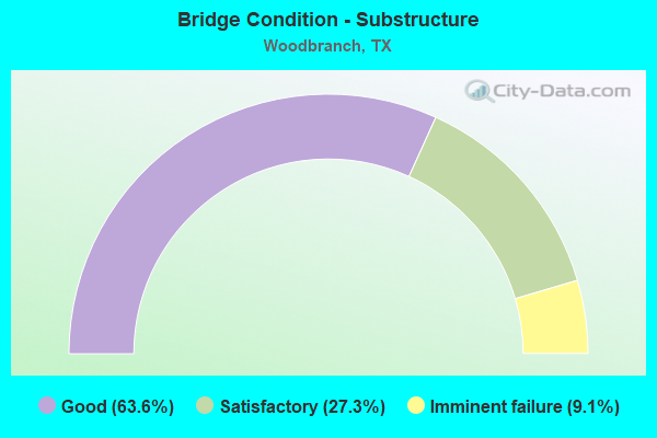
- Bridge Condition - Substructure
- 63.6%Good
- 27.3%Satisfactory
- 9.1%Imminent failure
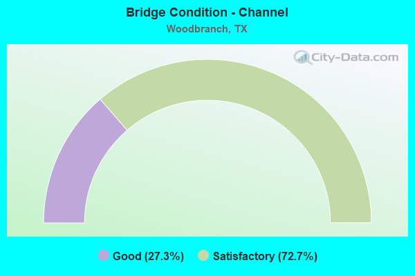
- Bridge Condition - Channel
- 27.3%Good
- 72.7%Satisfactory
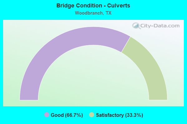
- Bridge Condition - Culverts
- 66.7%Good
- 33.3%Satisfactory
Find on map >> Show street view
Structure Number: 121700017705266, Location: 0.35 MI N OF FM 1485 (Lat: 30.160000, Lng: -95.212808), Route carried "on" structure: ServiceUS 59, Year Built: 2007, Status: Open, Structure Length: 39.01m (127.99ft), Average Daily Traffic: 4,800 (year 2010), Truck Traffic: 3%, Average Future Daily Traffic: 4,440 (year 2030), Design Load: HL 93, Features Intersected: Caney Creek
Minimum Vertical Clearance: 30+ m (98+ ft), Kilometerpoint: 14.093, Lanes on structure: 2, Lanes under structure: 4, Owner: State Highway Agency, Approaching Roadway Width: 12.2m (40.0ft), Material/Design: Prestressed concrete, Design/Construction: Stringer/Multi-beam, Number Of Spans In Main Unit: 10, Number Of Approach Spans: 1, Length of Maximum Span: 36.6m (120.1ft), Curb-To-Curb Width: 12.2m (40.0ft), Out-to-Out Width: 12.9m (42.3ft)
Condition: Deck: Good, Superstructure: Good, Substructure: Good, Channel: Satisfactory, Operating Rating: 54.4 metric tons, Method Used To Determine Operating Rating: Assigned ratings based on Load and Resistance Factor Design (LRFD) reported in metric tons, Inventory Rating: 32.7 metric tons, Method Used To Determine Inventory Rating: Assigned ratings based on Load and Resistance Factor Design (LRFD) reported in metric tons, Structural Evaluation: Better than present minimum criteria, Deck Geometry: Better than present minimum criteria, Waterway Adequacy: Superior to present desirable criteria, Approach Roadway Alignment: Equal to present desirable criteria, Designated Inspection Frequency: Every 24 months, Inspection Date: November 2020, Deck Structure Type: Concrete Cast-file-Place
Find on map >> Show street view
Structure Number: 121700017705267, Location: 0.25 MI S OF FM 1485 (Lat: 30.151608, Lng: -95.217292), Route carried "on" structure: US 59, Year Built: 2007, Status: Open, Structure Length: 1.49m (4.89ft), Average Daily Traffic: 46,640 (year 2010), Truck Traffic: 14%, Average Future Daily Traffic: 93,280 (year 2030), Features Intersected: DRAIN
Minimum Vertical Clearance: 30+ m (98+ ft), Kilometerpoint: 15.482, Lanes on structure: 12, Owner: State Highway Agency, Approaching Roadway Width: 71.9m (235.9ft), Skew: 30 degrees, Material/Design: Concrete, Design/Construction: Culvert, Number Of Spans In Main Unit: 4, Length of Maximum Span: 3.0m (9.8ft)
Condition: Channel: Good, Culverts: Good, Operating Rating: 44.4 metric tons, Method Used To Determine Operating Rating: No rating analysis performed, Inventory Rating: 32.7 metric tons, Method Used To Determine Inventory Rating: No rating analysis performed, Structural Evaluation: Better than present minimum criteria, Waterway Adequacy: Superior to present desirable criteria, Approach Roadway Alignment: Equal to present desirable criteria, Designated Inspection Frequency: Every 48 months, Inspection Date: December 2020
Find on map >> Show street view
Structure Number: 121700017705268, Location: 0.35 MI N OF FM 1485 (Lat: 30.159642, Lng: -95.211967), Route carried "on" structure: ServiceUS 59, Year Built: 2007, Status: Open, Structure Length: 39.01m (127.99ft), Average Daily Traffic: 4,520 (year 2010), Truck Traffic: 3%, Average Future Daily Traffic: 4,380 (year 2030), Design Load: HL 93, Features Intersected: Caney Creek
Minimum Vertical Clearance: 30+ m (98+ ft), Kilometerpoint: 14.087, Lanes on structure: 2, Lanes under structure: 4, Owner: State Highway Agency, Approaching Roadway Width: 12.2m (40.0ft), Material/Design: Prestressed concrete, Design/Construction: Stringer/Multi-beam, Number Of Spans In Main Unit: 10, Number Of Approach Spans: 1, Length of Maximum Span: 36.6m (120.1ft), Curb-To-Curb Width: 12.2m (40.0ft), Out-to-Out Width: 12.9m (42.3ft)
Condition: Deck: Good, Superstructure: Good, Substructure: Good, Channel: Satisfactory, Operating Rating: 54.4 metric tons, Method Used To Determine Operating Rating: Assigned ratings based on Load and Resistance Factor Design (LRFD) reported in metric tons, Inventory Rating: 32.7 metric tons, Method Used To Determine Inventory Rating: Assigned ratings based on Load and Resistance Factor Design (LRFD) reported in metric tons, Structural Evaluation: Better than present minimum criteria, Deck Geometry: Better than present minimum criteria, Waterway Adequacy: Superior to present desirable criteria, Approach Roadway Alignment: Equal to present desirable criteria, Designated Inspection Frequency: Every 24 months, Inspection Date: November 2020, Deck Structure Type: Concrete Cast-file-Place
Find on map >> Show street view
Structure Number: 121700017705269, Location: 0.35 MI N OF FM 1485 (Lat: 30.159714, Lng: -95.212208), Route carried "on" structure: US 59, Year Built: 2007, Status: Open, Structure Length: 39.01m (127.99ft), Average Daily Traffic: 41,620 (year 2010), Truck Traffic: 13%, Average Future Daily Traffic: 58,270 (year 2030), Design Load: HL 93, Features Intersected: Caney Creek
Minimum Vertical Clearance: 30+ m (98+ ft), Kilometerpoint: 14.087, Lanes on structure: 6, Lanes under structure: 4, Owner: State Highway Agency, Approaching Roadway Width: 34.7m (113.8ft), Skew: 30 degrees, Material/Design: Prestressed concrete, Design/Construction: Stringer/Multi-beam, Number Of Spans In Main Unit: 10, Number Of Approach Spans: 1, Length of Maximum Span: 36.6m (120.1ft), Curb-To-Curb Width: 34.7m (113.8ft), Out-to-Out Width: 36.1m (118.4ft)
Condition: Deck: Good, Superstructure: Good, Substructure: Good, Channel: Satisfactory, Operating Rating: 54.4 metric tons, Method Used To Determine Operating Rating: Assigned ratings based on Load and Resistance Factor Design (LRFD) reported in metric tons, Inventory Rating: 32.7 metric tons, Method Used To Determine Inventory Rating: Assigned ratings based on Load and Resistance Factor Design (LRFD) reported in metric tons, Structural Evaluation: Better than present minimum criteria, Deck Geometry: Superior to present desirable criteria, Waterway Adequacy: Superior to present desirable criteria, Approach Roadway Alignment: Equal to present desirable criteria, Designated Inspection Frequency: Every 24 months, Inspection Date: November 2020, Deck Structure Type: Concrete Cast-file-Place
Find on map >> Show street view
Structure Number: 12170001770527, Location: 3.75 MI S OF FM 1485 (Lat: 30.154558, Lng: -95.215461), Route carried "on" structure: US 59, Year Built: 2007, Status: Open, Structure Length: 10.79m (35.40ft), Average Daily Traffic: 41,620 (year 2010), Truck Traffic: 13%, Average Future Daily Traffic: 58,270 (year 2030), Design Load: HL 93, Features Intersected: FM 1485
Minimum Vertical Clearance: 30+ m (98+ ft), Kilometerpoint: 15.030, Lanes on structure: 8, Lanes under structure: 8, Owner: State Highway Agency, Approaching Roadway Width: 42.1m (138.1ft), Skew: 32 degrees, Material/Design: Prestressed concrete, Design/Construction: Stringer/Multi-beam, Number Of Spans In Main Unit: 3, Length of Maximum Span: 37.8m (124.0ft), Curb-To-Curb Width: 42.1m (138.1ft), Out-to-Out Width: 43.4m (142.4ft)
Condition: Deck: Good, Superstructure: Good, Substructure: Good, Operating Rating: 54.4 metric tons, Method Used To Determine Operating Rating: Assigned ratings based on Load and Resistance Factor Design (LRFD) reported in metric tons, Inventory Rating: 32.7 metric tons, Method Used To Determine Inventory Rating: Assigned ratings based on Load and Resistance Factor Design (LRFD) reported in metric tons, Structural Evaluation: Better than present minimum criteria, Deck Geometry: Superior to present desirable criteria, Underclear: Equal to present desirable criteria, Approach Roadway Alignment: Equal to present desirable criteria, Length Of Structure Improvement: 10.79m (35.40ft), Designated Inspection Frequency: Every 24 months, Inspection Date: November 2020, Bridge Improvement Cost: $28,000, Roadway Improvement Cost: $7,000, Total Project Cost: $35,000, Deck Structure Type: Concrete Cast-file-Place
Find on map >> Show street view
Structure Number: 121700017705308, Location: 1.30 MI N OF FM 1485 (Lat: 30.171661, Lng: -95.205125), Route carried "on" structure: US 59, Year Built: 2002, Status: Open, Structure Length: 0.98m (3.22ft), Average Daily Traffic: 41,620 (year 2010), Truck Traffic: 13%, Average Future Daily Traffic: 58,270 (year 2030), Design Load: HS 20, Features Intersected: DRAIN
Minimum Vertical Clearance: 30+ m (98+ ft), Kilometerpoint: 12.983, Lanes on structure: 12, Owner: State Highway Agency, Approaching Roadway Width: 65.8m (215.9ft), Skew: 20 degrees, Material/Design: Concrete, Design/Construction: Culvert, Number Of Spans In Main Unit: 5, Length of Maximum Span: 1.5m (4.9ft)
Condition: Channel: Good, Culverts: Good, Operating Rating: 54.4 metric tons, Method Used To Determine Operating Rating: Assigned rating based on Load Factor Design (LFD) reported in metric tons, Inventory Rating: 32.7 metric tons, Method Used To Determine Inventory Rating: Assigned rating based on Load Factor Design (LFD) reported in metric tons, Structural Evaluation: Better than present minimum criteria, Waterway Adequacy: Equal to present minimum criteria, Approach Roadway Alignment: Equal to present desirable criteria, Designated Inspection Frequency: Every 48 months, Inspection Date: December 2020
Find on map >> Show street view
Structure Number: 121700017705314, Location: 1.45 MI N OF FM 1485 (Lat: 30.173578, Lng: -95.203447), Route carried "on" structure: US 59, Year Built: 2002, Year Reconstructed: 2007, Status: Open, Structure Length: 9.08m (29.79ft), Average Daily Traffic: 42,000 (year 2010), Truck Traffic: 13%, Average Future Daily Traffic: 58,800 (year 2030), Design Load: HS 20, Features Intersected: ROMAN FOREST BLVD
Minimum Vertical Clearance: 30+ m (98+ ft), Kilometerpoint: 12.720, Lanes on structure: 8, Lanes under structure: 7, Owner: State Highway Agency, Approaching Roadway Width: 42.1m (138.1ft), Skew: 30 degrees, Material/Design: Prestressed concrete, Design/Construction: Stringer/Multi-beam, Number Of Spans In Main Unit: 3, Length of Maximum Span: 32.0m (105.0ft), Curb-To-Curb Width: 42.1m (138.1ft), Out-to-Out Width: 43.6m (143.0ft)
Condition: Deck: Good, Superstructure: Satisfactory, Substructure: Good, Operating Rating: 54.4 metric tons, Method Used To Determine Operating Rating: Assigned rating based on Load Factor Design (LFD) reported in metric tons, Inventory Rating: 32.7 metric tons, Method Used To Determine Inventory Rating: Assigned rating based on Load Factor Design (LFD) reported in metric tons, Structural Evaluation: Equal to present minimum criteria, Deck Geometry: Superior to present desirable criteria, Underclear: Meets minimum limits, Approach Roadway Alignment: Equal to present desirable criteria, Designated Inspection Frequency: Every 24 months, Inspection Date: November 2020, Deck Structure Type: Concrete Cast-file-Place
Find on map >> Show street view
Structure Number: 121700017714043, Location: 0.3 MI N OF FM 1485 (Lat: 30.159828, Lng: -95.209892), Route carried "on" structure: Business State highway 494, Year Built: 1948, Status: Closed, Structure Length: 32.49m (106.59ft), Average Daily Traffic: 1,873 (year 2020), Truck Traffic: 6%, Average Future Daily Traffic: 2,330 (year 2033), Design Load: HS 20, Features Intersected: CANEY CREEK
Minimum Vertical Clearance: 30+ m (98+ ft), Kilometerpoint: 45.779, Lanes on structure: 2, Owner: State Highway Agency, Approaching Roadway Width: 9.1m (29.9ft), Material/Design: Steel continuous, Design/Construction: Stringer/Multi-beam, Number Of Spans In Main Unit: 3, Number Of Approach Spans: 23, Length of Maximum Span: 19.8m (65.0ft), Curb-To-Curb Width: 8.4m (27.6ft), Out-to-Out Width: 9.6m (31.5ft)
Condition: Deck: Fair, Superstructure: Satisfactory, Substructure: Satisfactory, Channel: Satisfactory, Deck Geometry: Meets minimum limits, Waterway Adequacy: Equal to present minimum criteria, Approach Roadway Alignment: Equal to present desirable criteria, Length Of Structure Improvement: 32.46m (106.50ft), Designated Inspection Frequency: Every 24 months, Inspection Date: October 2020, Bridge Improvement Cost: $60,000, Roadway Improvement Cost: $15,000, Total Project Cost: $75,000, Deck Structure Type: Concrete Cast-file-Place
Find on map >> Show street view
Structure Number: 121700106201015, Location: 1.3 MI E OF LP 494 (Lat: 30.148817, Lng: -95.192136), Route carried "on" structure: State highway 1485, Year Built: 1989, Status: Open, Structure Length: 14.63m (48.00ft), Average Daily Traffic: 20,783 (year 2020), Truck Traffic: 4%, Average Future Daily Traffic: 19,390 (year 2033), Design Load: HS 20, Features Intersected: CANEY CREEK
Minimum Vertical Clearance: 30+ m (98+ ft), Kilometerpoint: 1.996, Lanes on structure: 2, Owner: State Highway Agency, Approaching Roadway Width: 13.4m (44.0ft), Material/Design: Prestressed concrete, Design/Construction: Stringer/Multi-beam, Number Of Spans In Main Unit: 7, Length of Maximum Span: 24.4m (80.1ft), Curb-To-Curb Width: 13.1m (43.0ft), Out-to-Out Width: 14.0m (45.9ft)
Condition: Deck: Good, Superstructure: Good, Substructure: Good, Channel: Good, Operating Rating: 54.4 metric tons, Method Used To Determine Operating Rating: Assigned rating based on Load Factor Design (LFD) reported in metric tons, Inventory Rating: 32.7 metric tons, Method Used To Determine Inventory Rating: Assigned rating based on Load Factor Design (LFD) reported in metric tons, Structural Evaluation: Better than present minimum criteria, Deck Geometry: Somewhat better than minimum adequacy, Waterway Adequacy: Equal to present minimum criteria, Approach Roadway Alignment: Equal to present desirable criteria, Designated Inspection Frequency: Every 24 months, Inspection Date: October 2020, Deck Structure Type: Concrete Precast Panels
Find on map >> Show street view
Structure Number: 121700106203012, Location: 2.50 MI NW OF US 59 (Lat: 30.177972, Lng: -95.243728), Route carried "on" structure: State highway 1485, Year Built: 1986, Status: Open, Structure Length: 4.88m (16.01ft), Average Daily Traffic: 8,841 (year 2016), Truck Traffic: 5%, Average Future Daily Traffic: 15,650 (year 2033), Design Load: HS 20, Features Intersected: DRY CREEK
Minimum Vertical Clearance: 30+ m (98+ ft), Kilometerpoint: 39.735, Lanes on structure: 2, Owner: State Highway Agency, Approaching Roadway Width: 13.4m (44.0ft), Material/Design: Concrete, Design/Construction: Stringer/Multi-beam, Number Of Spans In Main Unit: 4, Length of Maximum Span: 12.2m (40.0ft), Curb-To-Curb Width: 15.6m (51.2ft), Out-to-Out Width: 16.5m (54.1ft)
Condition: Deck: Fair, Superstructure: Satisfactory, Substructure: Good, Channel: Satisfactory, Operating Rating: 68.0 metric tons, Method Used To Determine Operating Rating: Load Factor (LF), Inventory Rating: 40.8 metric tons, Method Used To Determine Inventory Rating: Load Factor (LF), Structural Evaluation: Equal to present minimum criteria, Deck Geometry: Superior to present desirable criteria, Waterway Adequacy: Equal to present minimum criteria, Approach Roadway Alignment: Equal to present desirable criteria, Length Of Structure Improvement: 4.88m (16.01ft), Designated Inspection Frequency: Every 24 months, Inspection Date: October 2020, Deck Structure Type: Concrete Cast-file-Place
Find on map >> Show street view
Structure Number: 121700AA1837103, Location: 0.5 MI E OF FM 1484 (Lat: 30.188556, Lng: -95.246719), Route carried "on" structure: County highway , Year Built: 1989, Status: Open, Structure Length: 1.28m (4.20ft), Average Daily Traffic: 500 (year 2015), Average Future Daily Traffic: 1,000 (year 2035), Features Intersected: CANEY CREEK DRAW, Facility Carried by Structure: AZALEA LANE
Minimum Vertical Clearance: 30+ m (98+ ft), Kilometerpoint: 0.322, Lanes on structure: 2, Owner: County Highway Agency, Approaching Roadway Width: 6.1m (20.0ft), Material/Design: Steel, Design/Construction: Stringer/Multi-beam, Number Of Spans In Main Unit: 1, Length of Maximum Span: 12.2m (40.0ft), Curb-To-Curb Width: 7.9m (25.9ft), Out-to-Out Width: 7.9m (25.9ft)
Condition: Deck: Satisfactory, Superstructure: Satisfactory, Substructure: Satisfactory, Channel: Satisfactory, Operating Rating: 33.6 metric tons, Method Used To Determine Operating Rating: Allowable Stress (AS), Inventory Rating: 20.9 metric tons, Method Used To Determine Inventory Rating: Allowable Stress (AS), Structural Evaluation: Equal to present minimum criteria, Deck Geometry: Somewhat better than minimum adequacy, Waterway Adequacy: Better than present minimum criteria, Approach Roadway Alignment: Equal to present minimum criteria, Designated Inspection Frequency: Every 24 months, Inspection Date: September 2021, Deck Structure Type: Concrete Cast-file-Place
Find on map >> Show street view
Structure Number: 121700AA1845001, Location: 0.10 MI S OF AZALEA LN (Lat: 30.186117, Lng: -95.245419), Route carried "on" structure: County highway , Year Built: 1991, Status: Open, Structure Length: 1.04m (3.41ft), Average Daily Traffic: 50 (year 2009), Average Future Daily Traffic: 100 (year 2026), Features Intersected: CANEY CREEK DRAW, Facility Carried by Structure: LILAC LANE
Minimum Vertical Clearance: 30+ m (98+ ft), Kilometerpoint: 0.161, Lanes on structure: 1, Owner: County Highway Agency, Approaching Roadway Width: 4.3m (14.1ft), Material/Design: Steel, Design/Construction: Culvert, Number Of Spans In Main Unit: 4, Length of Maximum Span: 2.4m (7.9ft)
Condition: Channel: Satisfactory, Culverts: Satisfactory, Operating Rating: 32.7 metric tons, Method Used To Determine Operating Rating: Field evaluation and documented engineering judgment, Inventory Rating: 24.5 metric tons, Method Used To Determine Inventory Rating: Field evaluation and documented engineering judgment, Structural Evaluation: Equal to present minimum criteria, Waterway Adequacy: Meets minimum limits, Approach Roadway Alignment: Equal to present desirable criteria, Designated Inspection Frequency: Every 24 months, Inspection Date: September 2021
Find on map >> Show street view
Structure Number: 121700AA1845104, Location: 0.6 MI E OF FM 1485 (Lat: 30.191231, Lng: -95.243536), Route carried "on" structure: County highway , Year Built: 1986, Status: Open, Structure Length: 4.69m (15.39ft), Average Daily Traffic: 420 (year 2009), Average Future Daily Traffic: 1,000 (year 2026), Features Intersected: CANEY CREEK, Facility Carried by Structure: SYCAMORE LANE
Minimum Vertical Clearance: 30+ m (98+ ft), Kilometerpoint: 0.161, Lanes on structure: 2, Owner: County Highway Agency, Approaching Roadway Width: 8.5m (27.9ft), Material/Design: Concrete, Design/Construction: Stringer/Multi-beam, Number Of Spans In Main Unit: 5, Length of Maximum Span: 9.1m (29.9ft), Curb-To-Curb Width: 8.7m (28.5ft), Out-to-Out Width: 9.2m (30.2ft)
Condition: Deck: Good, Superstructure: Good, Substructure: Satisfactory, Channel: Satisfactory, Operating Rating: 32.7 metric tons, Method Used To Determine Operating Rating: Assigned rating based on Load Factor Design (LFD) reported in metric tons, Inventory Rating: 24.5 metric tons, Method Used To Determine Inventory Rating: Assigned rating based on Load Factor Design (LFD) reported in metric tons, Structural Evaluation: Equal to present minimum criteria, Deck Geometry: Somewhat better than minimum adequacy, Waterway Adequacy: Better than present minimum criteria, Approach Roadway Alignment: Equal to present desirable criteria, Designated Inspection Frequency: Every 24 months, Inspection Date: September 2021, Deck Structure Type: Concrete Cast-file-Place
Find on map >> Show street view
Structure Number: 121700R00020128, Location: 0.8 MI E OF US 59 (Lat: 30.182364, Lng: -95.183586), Route carried "on" structure: City street , Year Built: 1968, Status: Closed, Structure Length: 6.16m (20.21ft), Average Daily Traffic: 50 (year 2015), Average Future Daily Traffic: 100 (year 2035), Design Load: H 15, Features Intersected: PEACH CREEK, Facility Carried by Structure: WOODBRANCH DR
Minimum Vertical Clearance: 30+ m (98+ ft), Kilometerpoint: 1.046, Lanes on structure: 2, Owner: Town or Township Highway Agency, Approaching Roadway Width: 3.7m (12.1ft), Material/Design: Concrete, Design/Construction: Stringer/Multi-beam, Number Of Spans In Main Unit: 5, Length of Maximum Span: 12.2m (40.0ft), Curb-To-Curb Width: 7.3m (24.0ft), Out-to-Out Width: 8.0m (26.2ft)
Condition: Substructure: Imminent failure, Deck Geometry: Equal to present minimum criteria, Waterway Adequacy: Better than present minimum criteria, Approach Roadway Alignment: High priority of corrective action, Bridge Posting: Required (Relationship of Operating Rating to Maximum Legal Load: 10.0 - 19.9% below), Length Of Structure Improvement: 7.16m (23.49ft), Designated Inspection Frequency: Every 24 months, Inspection Date: October 2021, Bridge Improvement Cost: $20,000, Roadway Improvement Cost: $5,000, Total Project Cost: $25,000, Deck Structure Type: Concrete Cast-file-Place, Wearing Surface/Protective System: Wearing Surface: Monolithic Concrete
Find on map >> Show street view
Structure Number: 12170001770527, Location: 3.75 MI S OF FM 1485 (Lat: 30.155103, Lng: -95.215214), Route carried "under" structure: State highway 1485, Year Built: 2007, Structure Length: 0. m, Average Daily Traffic: 10,000 (year 2016), Truck Traffic: 6%, Features Intersected: US 59, Facility Carried by Structure: US 59
Minimum Vertical Clearance: 5.39m (17.68ft), Kilometerpoint: 43.782, Lanes on structure: 6, Material/Design: Prestressed concrete, Design/Construction: Stringer/Multi-beam, Length of Maximum Span: 37.8m (124.0ft)
Find on map >> Show street view
Structure Number: 121700017705314, Location: 1.45 MI N OF FM 1485 (Lat: 30.173108, Lng: -95.203353), Route carried "under" structure: County highway , Year Built: 2002, Structure Length: 0. m, Average Daily Traffic: 500 (year 2016), Truck Traffic: 3%, Features Intersected: US 59, Facility Carried by Structure: US 59
Minimum Vertical Clearance: 5.13m (16.83ft), Kilometerpoint: 0.161, Lanes on structure: 5, Material/Design: Prestressed concrete, Design/Construction: Stringer/Multi-beam, Length of Maximum Span: 32.0m (105.0ft)