Bridge Statistics for Woodbourne, Pennsylvania (PA)
Condition, Traffic, Stress, Structural Evaluation, Project Costs
- National Bridge Inventory (NBI) Statistics
- 24Number of bridges
- 240ft / 73.4mTotal length
- $5,934,000Total costs
- 612,486Total average daily traffic
- 46,979Total average daily truck traffic
- National Bridge Inventory (NBI) Registered Bridges for Woodbourne
- No street view available for this location
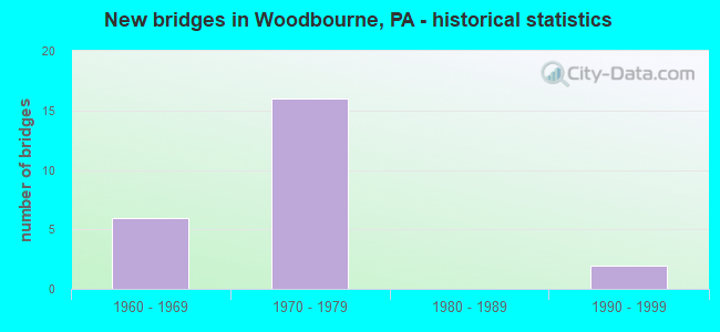
- New bridges - historical statistics
- 61960-1969
- 161970-1979
- 21990-1999

- Reconstructed bridges - Historical Statistics
- 21990-1999
- 02000-2009
- 32010-2019


- Bridge Condition - Deck
- 30.8%Good
- 38.5%Satisfactory
- 30.8%Fair

- Bridge Condition - Superstructure
- 38.5%Good
- 15.4%Satisfactory
- 46.2%Fair

- Bridge Condition - Substructure
- 15.4%Good
- 30.8%Satisfactory
- 46.2%Fair
- 7.7%Poor

- Bridge Condition - Channel
- 33.3%Good
- 33.3%Satisfactory
- 33.3%Fair
Find on map >> Show street view
Structure Number: 6731, Location: WOODBOURNE 37F08 (Lat: 40.190044, Lng: -74.891461), Route carried "on" structure: US 1, Year Built: 1966, Status: Open, Structure Length: 10.15m (33.30ft), Average Daily Traffic: 49,875 (year 2022), Truck Traffic: 5%, Average Future Daily Traffic: 63,196 (year 2032), Design Load: HS 20, Features Intersected: CSX;SEPTA
Minimum Vertical Clearance: 30+ m (98+ ft), Kilometerpoint: 10.594, Lanes on structure: 2, Base Highway Network: Yes, Owner: State Highway Agency, Approaching Roadway Width: 20.1m (65.9ft), Skew: 35 degrees, Material/Design: Steel continuous, Design/Construction: Stringer/Multi-beam, Number Of Spans In Main Unit: 4, Length of Maximum Span: 29.3m (96.1ft), Curb or Sidewalk Widths: Left: 0.2m (0.7ft), Right: 0.2m (0.7ft), Curb-To-Curb Width: 17.1m (56.1ft), Out-to-Out Width: 20.0m (65.6ft)
Condition: Deck: Satisfactory, Superstructure: Fair, Substructure: Fair, Operating Rating: 57.2 metric tons, Method Used To Determine Operating Rating: Load Factor (LF), Inventory Rating: 34.5 metric tons, Method Used To Determine Inventory Rating: Load Factor (LF), Structural Evaluation: Somewhat better than minimum adequacy, Deck Geometry: Superior to present desirable criteria, Underclear: High priority of corrective action, Approach Roadway Alignment: Equal to present desirable criteria, Length Of Structure Improvement: 10.10m (33.14ft), Designated Inspection Frequency: Every 24 months, Inspection Date: May 2021, Bridge Improvement Cost: $50,000, Roadway Improvement Cost: $146,000, Total Project Cost: $670,000, Deck Structure Type: Concrete Cast-file-Place, Wearing Surface/Protective System: Wearing Surface: Latex Concrete
Find on map >> Show street view
Structure Number: 6732, Location: .6MI.S.W.I-95 37F08 (Lat: 40.190419, Lng: -74.890144), Route carried "on" structure: US 1, Year Built: 1967, Year Reconstructed: 1996, Status: Open, Structure Length: 1.16m (3.81ft), Average Daily Traffic: 49,875 (year 2022), Truck Traffic: 5%, Average Future Daily Traffic: 63,196 (year 2032), Design Load: HS 20, Features Intersected: WOODBOURNE ROAD
Minimum Vertical Clearance: 30+ m (98+ ft), Kilometerpoint: 11.177, Lanes on structure: 2, Lanes under structure: 2, Base Highway Network: Yes, Owner: State Highway Agency, Approaching Roadway Width: 20.1m (65.9ft), Skew: 30 degrees, Material/Design: Prestressed concrete, Design/Construction: Stringer/Multi-beam, Number Of Spans In Main Unit: 1, Length of Maximum Span: 11.6m (38.1ft), Curb or Sidewalk Widths: Left: 0.2m (0.7ft), Right: 0.2m (0.7ft), Curb-To-Curb Width: 20.1m (65.9ft), Out-to-Out Width: 21.8m (71.5ft)
Condition: Deck: Satisfactory, Superstructure: Good, Substructure: Fair, Operating Rating: 72.6 metric tons, Method Used To Determine Operating Rating: Load Factor (LF), Inventory Rating: 34.5 metric tons, Method Used To Determine Inventory Rating: Load Factor (LF), Structural Evaluation: Somewhat better than minimum adequacy, Deck Geometry: Superior to present desirable criteria, Underclear: Meets minimum limits, Approach Roadway Alignment: Equal to present desirable criteria, Length Of Structure Improvement: 1.20m (3.94ft), Designated Inspection Frequency: Every 24 months, Inspection Date: October 2020, Bridge Improvement Cost: $8,000, Roadway Improvement Cost: $31,000, Total Project Cost: $107,000, Deck Structure Type: Concrete Cast-file-Place, Wearing Surface/Protective System: Wearing Surface: Latex Concrete
Find on map >> Show street view
Structure Number: 6734, Location: .3MI.SW OF I-95 37G07 (Lat: 40.191869, Lng: -74.885131), Route carried "on" structure: US 1, Year Built: 1966, Year Reconstructed: 1996, Status: Open, Structure Length: 7.44m (24.41ft), Average Daily Traffic: 58,476 (year 2022), Truck Traffic: 7%, Average Future Daily Traffic: 74,308 (year 2032), Design Load: HS 20, Features Intersected: NORFOLK SOUTHERN
Minimum Vertical Clearance: 30+ m (98+ ft), Kilometerpoint: 11.177, Lanes on structure: 2, Base Highway Network: Yes, Owner: State Highway Agency, Approaching Roadway Width: 24.7m (81.0ft), Skew: 34 degrees, Material/Design: Steel continuous, Design/Construction: Stringer/Multi-beam, Number Of Spans In Main Unit: 3, Length of Maximum Span: 28.0m (91.9ft), Curb or Sidewalk Widths: Left: 0.2m (0.7ft), Right: 0.2m (0.7ft), Curb-To-Curb Width: 17.1m (56.1ft), Out-to-Out Width: 20.0m (65.6ft)
Condition: Deck: Satisfactory, Superstructure: Fair, Substructure: Satisfactory, Operating Rating: 56.2 metric tons, Method Used To Determine Operating Rating: Load Factor (LF), Inventory Rating: 33.6 metric tons, Method Used To Determine Inventory Rating: Load Factor (LF), Structural Evaluation: Somewhat better than minimum adequacy, Deck Geometry: Superior to present desirable criteria, Underclear: High priority of corrective action, Approach Roadway Alignment: Equal to present desirable criteria, Length Of Structure Improvement: 7.40m (24.28ft), Designated Inspection Frequency: Every 24 months, Inspection Date: June 2020, Bridge Improvement Cost: $70,000, Roadway Improvement Cost: $206,000, Total Project Cost: $945,000, Deck Structure Type: Concrete Cast-file-Place, Wearing Surface/Protective System: Wearing Surface: Latex Concrete
Find on map >> Show street view
Structure Number: 6866, Location: 1MI.N.LANGHORNE 37H08 (Lat: 40.190506, Lng: -74.881886), Route carried "on" structure: Interstate 295, Year Built: 1972, Status: Open, Structure Length: 12.41m (40.72ft), Average Daily Traffic: 25,069 (year 2021), Truck Traffic: 6%, Average Future Daily Traffic: 41,676 (year 2032), Design Load: HS 20, Features Intersected: NORFOLK SOUTHERN;CSX
Minimum Vertical Clearance: 30+ m (98+ ft), Kilometerpoint: 8.047, Lanes on structure: 2, Base Highway Network: Yes, Owner: State Highway Agency, Approaching Roadway Width: 12.2m (40.0ft), Skew: 11 degrees, Material/Design: Prestressed concrete, Design/Construction: Stringer/Multi-beam, Number Of Spans In Main Unit: 6, Length of Maximum Span: 23.2m (76.1ft), Curb or Sidewalk Widths: Left: 0.2m (0.7ft), Right: 0.2m (0.7ft), Curb-To-Curb Width: 12.2m (40.0ft), Out-to-Out Width: 13.4m (44.0ft)
Condition: Deck: Satisfactory, Superstructure: Satisfactory, Substructure: Satisfactory, Operating Rating: 58.1 metric tons, Method Used To Determine Operating Rating: Load Factor (LF), Inventory Rating: 23.6 metric tons, Method Used To Determine Inventory Rating: Load Factor (LF), Structural Evaluation: Somewhat better than minimum adequacy, Deck Geometry: Better than present minimum criteria, Underclear: High priority of corrective action, Approach Roadway Alignment: Equal to present desirable criteria, Length Of Structure Improvement: 13.00m (42.65ft), Designated Inspection Frequency: Every 24 months, Inspection Date: June 2020, Bridge Improvement Cost: $89,000, Roadway Improvement Cost: $261,000, Total Project Cost: $1,197,000, Deck Structure Type: Concrete Cast-file-Place, Wearing Surface/Protective System: Wearing Surface: Bituminous
Find on map >> Show street view
Structure Number: 6868, Location: 1MI.N.LANGHORNE 37H07 (Lat: 40.192992, Lng: -74.879394), Route carried "on" structure: Interstate 295, Year Built: 1972, Year Reconstructed: 2010, Status: Open, Structure Length: 6.89m (22.60ft), Average Daily Traffic: 29,853 (year 2022), Truck Traffic: 9%, Average Future Daily Traffic: 38,459 (year 2032), Design Load: HS 20+Mod, Features Intersected: LR 281 PARALLEL: US 1
Minimum Vertical Clearance: 30+ m (98+ ft), Kilometerpoint: 8.047, Lanes on structure: 3, Lanes under structure: 6, Base Highway Network: Yes, Owner: State Highway Agency, Approaching Roadway Width: 18.3m (60.0ft), Skew: 13 degrees, Material/Design: Prestressed concrete, Design/Construction: Stringer/Multi-beam, Number Of Spans In Main Unit: 4, Length of Maximum Span: 20.4m (66.9ft), Curb or Sidewalk Widths: Left: 0.2m (0.7ft), Right: 0.2m (0.7ft), Curb-To-Curb Width: 15.4m (50.5ft), Out-to-Out Width: 17.3m (56.8ft)
Condition: Deck: Fair, Superstructure: Fair, Substructure: Fair, Operating Rating: 72.6 metric tons, Method Used To Determine Operating Rating: Load Factor (LF), Inventory Rating: 24.5 metric tons, Method Used To Determine Inventory Rating: Load Factor (LF), Structural Evaluation: Somewhat better than minimum adequacy, Deck Geometry: Somewhat better than minimum adequacy, Underclear: High priority of corrective action, Approach Roadway Alignment: Equal to present desirable criteria, Length Of Structure Improvement: 7.80m (25.59ft), Designated Inspection Frequency: Every 24 months, Inspection Date: Febuary 2021, Bridge Improvement Cost: $63,000, Roadway Improvement Cost: $186,000, Total Project Cost: $852,000, Deck Structure Type: Concrete Cast-file-Place, Wearing Surface/Protective System: Wearing Surface: Bituminous
Find on map >> Show street view
Structure Number: 6871, Location: 1MI.N.LANGHORNE 37H07 (Lat: 40.192928, Lng: -74.879811), Route carried "on" structure: Interstate 295, Year Built: 1972, Year Reconstructed: 2010, Status: Open, Structure Length: 6.83m (22.41ft), Average Daily Traffic: 32,348 (year 2022), Truck Traffic: 10%, Average Future Daily Traffic: 41,676 (year 2032), Design Load: HS 20+Mod, Features Intersected: LR 281 PARALLEL: US 1
Minimum Vertical Clearance: 30+ m (98+ ft), Kilometerpoint: 8.047, Lanes on structure: 3, Lanes under structure: 6, Base Highway Network: Yes, Owner: State Highway Agency, Approaching Roadway Width: 18.3m (60.0ft), Skew: 13 degrees, Material/Design: Prestressed concrete, Design/Construction: Stringer/Multi-beam, Number Of Spans In Main Unit: 4, Length of Maximum Span: 20.4m (66.9ft), Curb or Sidewalk Widths: Left: 0.2m (0.7ft), Right: 0.2m (0.7ft), Curb-To-Curb Width: 15.4m (50.5ft), Out-to-Out Width: 16.6m (54.5ft)
Condition: Deck: Fair, Superstructure: Fair, Substructure: Fair, Operating Rating: 72.6 metric tons, Method Used To Determine Operating Rating: Load Factor (LF), Inventory Rating: 23.6 metric tons, Method Used To Determine Inventory Rating: Load Factor (LF), Structural Evaluation: Somewhat better than minimum adequacy, Deck Geometry: Somewhat better than minimum adequacy, Underclear: High priority of corrective action, Approach Roadway Alignment: Equal to present desirable criteria, Length Of Structure Improvement: 7.70m (25.26ft), Designated Inspection Frequency: Every 24 months, Inspection Date: Febuary 2021, Bridge Improvement Cost: $97,000, Roadway Improvement Cost: $286,000, Total Project Cost: $1,312,000, Deck Structure Type: Concrete Cast-file-Place, Wearing Surface/Protective System: Wearing Surface: Bituminous
Find on map >> Show street view
Structure Number: 6872, Location: 2MI.N.LANGHORNE 37J05 (Lat: 40.203803, Lng: -74.874831), Route carried "on" structure: Interstate 295, Year Built: 1972, Year Reconstructed: 2010, Status: Open, Structure Length: 6.49m (21.29ft), Average Daily Traffic: 29,853 (year 2022), Truck Traffic: 9%, Average Future Daily Traffic: 38,459 (year 2032), Design Load: HS 20+Mod, Features Intersected: CSX;SEPTA-TRENTON BRANCH
Minimum Vertical Clearance: 30+ m (98+ ft), Kilometerpoint: 9.656, Lanes on structure: 2, Base Highway Network: Yes, Owner: State Highway Agency, Approaching Roadway Width: 14.6m (47.9ft), Skew: 14 degrees, Material/Design: Prestressed concrete, Design/Construction: Stringer/Multi-beam, Number Of Spans In Main Unit: 3, Length of Maximum Span: 22.9m (75.1ft), Curb or Sidewalk Widths: Left: 0.2m (0.7ft), Right: 0.2m (0.7ft), Curb-To-Curb Width: 11.7m (38.4ft), Out-to-Out Width: 13.0m (42.7ft)
Condition: Deck: Fair, Superstructure: Fair, Substructure: Fair, Operating Rating: 69.9 metric tons, Method Used To Determine Operating Rating: Load Factor (LF), Inventory Rating: 27.2 metric tons, Method Used To Determine Inventory Rating: Load Factor (LF), Structural Evaluation: Somewhat better than minimum adequacy, Deck Geometry: Equal to present minimum criteria, Underclear: High priority of corrective action, Approach Roadway Alignment: Equal to present desirable criteria, Length Of Structure Improvement: 7.50m (24.61ft), Designated Inspection Frequency: Every 24 months, Inspection Date: May 2021, Bridge Improvement Cost: $23,000, Roadway Improvement Cost: $67,000, Total Project Cost: $308,000, Deck Structure Type: Concrete Cast-file-Place, Wearing Surface/Protective System: Wearing Surface: Bituminous
Find on map >> Show street view
Structure Number: 6876, Location: WEST OF YARDLEY 37H02 (Lat: 40.219831, Lng: -74.879711), Route carried "on" structure: Interstate 295, Year Built: 1972, Status: Open, Structure Length: 3.47m (11.38ft), Average Daily Traffic: 29,853 (year 2022), Truck Traffic: 9%, Average Future Daily Traffic: 38,459 (year 2032), Design Load: HS 20, Features Intersected: LANGHORNE-YARDLEY ROAD
Minimum Vertical Clearance: 30+ m (98+ ft), Kilometerpoint: 11.265, Lanes on structure: 2, Lanes under structure: 2, Base Highway Network: Yes, Owner: State Highway Agency, Approaching Roadway Width: 12.8m (42.0ft), Skew: 12 degrees, Material/Design: Prestressed concrete, Design/Construction: Stringer/Multi-beam, Number Of Spans In Main Unit: 3, Length of Maximum Span: 14.9m (48.9ft), Curb or Sidewalk Widths: Left: 0.2m (0.7ft), Right: 0.2m (0.7ft), Curb-To-Curb Width: 11.8m (38.7ft), Out-to-Out Width: 12.9m (42.3ft)
Condition: Deck: Good, Superstructure: Fair, Substructure: Satisfactory, Operating Rating: 73.5 metric tons, Method Used To Determine Operating Rating: Load Factor (LF), Inventory Rating: 20.9 metric tons, Method Used To Determine Inventory Rating: Load Factor (LF), Structural Evaluation: Somewhat better than minimum adequacy, Deck Geometry: Equal to present minimum criteria, Underclear: Meets minimum limits, Approach Roadway Alignment: Equal to present desirable criteria, Length Of Structure Improvement: 4.40m (14.44ft), Designated Inspection Frequency: Every 24 months, Inspection Date: May 2021, Bridge Improvement Cost: $27,000, Roadway Improvement Cost: $78,000, Total Project Cost: $359,000, Deck Structure Type: Concrete Cast-file-Place, Wearing Surface/Protective System: Wearing Surface: Bituminous
Find on map >> Show street view
Structure Number: 7007, Location: JUST E.OF NEWTOWN 32E13 (Lat: 40.231314, Lng: -74.901150), Route carried "on" structure: State highway 332, Year Built: 1990, Status: Open, Structure Length: 4.33m (14.21ft), Average Daily Traffic: 26,931 (year 2020), Truck Traffic: 7%, Average Future Daily Traffic: 38,997 (year 2032), Design Load: HS 25 or greater, Features Intersected: SILVER LAKE;CORE CREEK, Facility Carried by Structure: NEWTOWN YARDLEY RD
Minimum Vertical Clearance: 30+ m (98+ ft), Kilometerpoint: 20.614, Lanes on structure: 4, Base Highway Network: Yes, Owner: State Highway Agency, Approaching Roadway Width: 24.7m (81.0ft), Skew: 32 degrees, Material/Design: Prestressed concrete, Design/Construction: Stringer/Multi-beam, Number Of Spans In Main Unit: 1, Length of Maximum Span: 41.5m (136.2ft), Curb or Sidewalk Widths: Left: 0.2m (0.7ft), Right: 0.2m (0.7ft), Curb-To-Curb Width: 24.8m (81.4ft), Out-to-Out Width: 26.4m (86.6ft)
Condition: Deck: Good, Superstructure: Good, Substructure: Good, Channel: Good, Inventory Rating: 52.6 metric tons, Method Used To Determine Inventory Rating: Load Factor (LF), Structural Evaluation: Better than present minimum criteria, Deck Geometry: Superior to present desirable criteria, Waterway Adequacy: Superior to present desirable criteria, Approach Roadway Alignment: Better than present minimum criteria, Length Of Structure Improvement: 5.20m (17.06ft), Designated Inspection Frequency: Every 24 months, Inspection Date: May 2021, Deck Structure Type: Concrete Cast-file-Place, Wearing Surface/Protective System: Wearing Surface: Monolithic Concrete, Deck Protection: Epoxy Coated Reinforcing
Find on map >> Show street view
Structure Number: 7242, Location: LANGHORNE GARDENS 37G09 (Lat: 40.185894, Lng: -74.887781), Route carried "on" structure: State highway , Year Built: 1972, Status: Open, Structure Length: 6.71m (22.01ft), Average Daily Traffic: 10,630 (year 2021), Truck Traffic: 4%, Average Future Daily Traffic: 19,089 (year 2032), Design Load: HS 20, Features Intersected: INTERSTATE 295, Facility Carried by Structure: WOODBOURNE ROAD
Minimum Vertical Clearance: 30+ m (98+ ft), Kilometerpoint: 7.142, Lanes on structure: 2, Lanes under structure: 4, Owner: State Highway Agency, Approaching Roadway Width: 14.6m (47.9ft), Material/Design: Steel continuous, Design/Construction: Stringer/Multi-beam, Number Of Spans In Main Unit: 2, Length of Maximum Span: 32.6m (107.0ft), Curb or Sidewalk Widths: Left: 0.2m (0.7ft), Right: 0.2m (0.7ft), Curb-To-Curb Width: 13.4m (44.0ft), Out-to-Out Width: 14.6m (47.9ft)
Condition: Deck: Fair, Superstructure: Satisfactory, Substructure: Satisfactory, Operating Rating: 67.1 metric tons, Method Used To Determine Operating Rating: Load Factor (LF), Inventory Rating: 39.9 metric tons, Method Used To Determine Inventory Rating: Load Factor (LF), Structural Evaluation: Equal to present minimum criteria, Deck Geometry: Equal to present minimum criteria, Underclear: Somewhat better than minimum adequacy, Approach Roadway Alignment: Equal to present desirable criteria, Length Of Structure Improvement: 7.70m (25.26ft), Designated Inspection Frequency: Every 24 months, Inspection Date: December 2020, Deck Structure Type: Concrete Cast-file-Place, Wearing Surface/Protective System: Wearing Surface: Monolithic Concrete
Find on map >> Show street view
Structure Number: 7245, Location: 2MI.S.E. NEWTOWN 37D04 (Lat: 40.211906, Lng: -74.907508), Route carried "on" structure: State highway , Year Built: 1976, Status: Open, Structure Length: 1.28m (4.20ft), Average Daily Traffic: 2,032 (year 2020), Truck Traffic: 3%, Average Future Daily Traffic: 4,021 (year 2032), Design Load: HS 20, Features Intersected: CORE CREEK, Facility Carried by Structure: WOODBOURNE ROAD
Minimum Vertical Clearance: 30+ m (98+ ft), Kilometerpoint: 11.529, Lanes on structure: 2, Base Highway Network: Yes, Owner: State Highway Agency, Approaching Roadway Width: 12.8m (42.0ft), Material/Design: Prestressed concrete, Design/Construction: Box Beam or Girders - Single/Spread, Number Of Spans In Main Unit: 1, Length of Maximum Span: 12.8m (42.0ft), Curb or Sidewalk Widths: Left: 1.6m (5.2ft), Right: 0.2m (0.7ft), Curb-To-Curb Width: 13.4m (44.0ft), Out-to-Out Width: 16.4m (53.8ft)
Condition: Deck: Good, Superstructure: Good, Substructure: Good, Channel: Satisfactory, Operating Rating: 53.5 metric tons, Method Used To Determine Operating Rating: Load Factor (LF), Inventory Rating: 31.8 metric tons, Method Used To Determine Inventory Rating: Load Factor (LF), Structural Evaluation: Better than present minimum criteria, Deck Geometry: Better than present minimum criteria, Waterway Adequacy: Superior to present desirable criteria, Approach Roadway Alignment: Equal to present desirable criteria, Length Of Structure Improvement: 1.90m (6.23ft), Designated Inspection Frequency: Every 24 months, Underwater Inspection Frequency: Every 60 months, Inspection Date: July 2021, Underwater Inspection Date: August 2021, Deck Structure Type: Concrete Cast-file-Place, Wearing Surface/Protective System: Wearing Surface: Monolithic Concrete, Deck Protection: Galvanized Reinforcing
Find on map >> Show street view
Structure Number: 7503, Location: 0.7 MI SE OF SR 332 (Lat: 40.218786, Lng: -74.902397), Route carried "on" structure: City street , Year Built: 1995, Status: Open, Structure Length: 1.71m (5.61ft), Average Daily Traffic: 500 (year 1998), Truck Traffic: 3%, Average Future Daily Traffic: 200 (year 2013), Design Load: HS 25 or greater, Features Intersected: CORE CREEK, Facility Carried by Structure: SILVER LAKE ROAD
Minimum Vertical Clearance: 30+ m (98+ ft), Kilometerpoint: 0.000, Lanes on structure: 2, Owner: County Highway Agency, Approaching Roadway Width: 8.5m (27.9ft), Material/Design: Prestressed concrete, Design/Construction: Box Beam or Girders - Multiple, Number Of Spans In Main Unit: 1, Length of Maximum Span: 16.8m (55.1ft), Curb or Sidewalk Widths: Left: 1.4m (4.6ft), Right: 0.0m, Curb-To-Curb Width: 8.5m (27.9ft), Out-to-Out Width: 11.1m (36.4ft)
Condition: Deck: Good, Superstructure: Good, Substructure: Fair, Channel: Fair, Inventory Rating: 63.5 metric tons, Method Used To Determine Inventory Rating: Load Factor (LF), Structural Evaluation: Somewhat better than minimum adequacy, Deck Geometry: Somewhat better than minimum adequacy, Waterway Adequacy: Equal to present desirable criteria, Approach Roadway Alignment: Equal to present desirable criteria, Length Of Structure Improvement: 1.10m (3.61ft), Designated Inspection Frequency: Every 24 months, Inspection Date: May 2020, Deck Structure Type: Concrete Cast-file-Place, Wearing Surface/Protective System: Wearing Surface: Monolithic Concrete, Deck Protection: Epoxy Coated Reinforcing
Find on map >> Show street view
Structure Number: 7766, Location: LR 281 PAR 37G08 (Lat: 40.190733, Lng: -74.883708), Route carried "on" structure: Ramp State highway , Year Built: 1972, Status: Open, Structure Length: 4.57m (14.99ft), Average Daily Traffic: 432 (year 2022), Truck Traffic: 13%, Average Future Daily Traffic: 740 (year 2032), Design Load: HS 20+Mod, Features Intersected: CSX, Facility Carried by Structure: RAMP J
Minimum Vertical Clearance: 30+ m (98+ ft), Kilometerpoint: 0.000, Lanes on structure: 1, Base Highway Network: Yes, Owner: State Highway Agency, Approaching Roadway Width: 8.5m (27.9ft), Skew: 2 degrees, Material/Design: Prestressed concrete, Design/Construction: Stringer/Multi-beam, Number Of Spans In Main Unit: 3, Length of Maximum Span: 13.4m (44.0ft), Curb or Sidewalk Widths: Left: 0.2m (0.7ft), Right: 0.2m (0.7ft), Curb-To-Curb Width: 9.2m (30.2ft), Out-to-Out Width: 10.4m (34.1ft)
Condition: Deck: Satisfactory, Superstructure: Good, Substructure: Poor, Operating Rating: 58.1 metric tons, Method Used To Determine Operating Rating: Load Factor (LF), Inventory Rating: 25.4 metric tons, Method Used To Determine Inventory Rating: Load Factor (LF), Structural Evaluation: Meets minimum limits, Deck Geometry: Superior to present desirable criteria, Underclear: High priority of corrective action, Approach Roadway Alignment: Better than present minimum criteria, Length Of Structure Improvement: 5.50m (18.04ft), Designated Inspection Frequency: Every 24 months, Inspection Date: May 2021, Bridge Improvement Cost: $14,000, Roadway Improvement Cost: $40,000, Total Project Cost: $184,000, Deck Structure Type: Concrete Cast-file-Place, Wearing Surface/Protective System: Wearing Surface: Bituminous
Find on map >> Show street view
Structure Number: 6732, Location: .6MI.S.W.I-95 37F08 (Lat: 40.190419, Lng: -74.890144), Route carried "under" structure: State highway , Year Built: 1967, Structure Length: 0. m, Average Daily Traffic: 10,630 (year 2021), Truck Traffic: 4%, Features Intersected: WOODBOURNE ROAD, Facility Carried by Structure: NEW US-1 BY-PASS
Minimum Vertical Clearance: 6.38m (20.93ft), Kilometerpoint: 8.150, Lanes on structure: 2, Lanes under structure: 2, Material/Design: Prestressed concrete, Design/Construction: Stringer/Multi-beam, Length of Maximum Span: 11.6m (38.1ft)
Find on map >> Show street view
Structure Number: 6868, Location: 1MI.N.LANGHORNE 37H07 (Lat: 40.192992, Lng: -74.879394), Route carried "under" structure: US 1, Year Built: 1972, Structure Length: 0. m, Average Daily Traffic: 31,614 (year 2022), Truck Traffic: 10%, Features Intersected: LR 281 PARALLEL: US 1, Facility Carried by Structure: INTERSTATE 295 EB
Minimum Vertical Clearance: 4.91m (16.11ft), Kilometerpoint: 12.130, Lanes on structure: 3, Lanes under structure: 3, Material/Design: Prestressed concrete, Design/Construction: Stringer/Multi-beam, Length of Maximum Span: 20.4m (66.9ft)
Find on map >> Show street view
Structure Number: 6868, Location: 1MI.N.LANGHORNE 37H07 (Lat: 40.192992, Lng: -74.879394), Route carried "under" structure: US 1, Year Built: 1972, Structure Length: 0. m, Average Daily Traffic: 33,590 (year 2022), Truck Traffic: 9%, Features Intersected: LR 281 PARALLEL: US 1, Facility Carried by Structure: INTERSTATE 295 EB
Minimum Vertical Clearance: 5.98m (19.62ft), Kilometerpoint: 12.105, Lanes on structure: 3, Lanes under structure: 3, Material/Design: Prestressed concrete, Design/Construction: Stringer/Multi-beam, Length of Maximum Span: 20.4m (66.9ft)
Find on map >> Show street view
Structure Number: 687, Location: .4MI.N.OF NEW US1 37J06 (Lat: 40.198475, Lng: -74.876092), Route carried "under" structure: Interstate 295, Year Built: 1967, Structure Length: 0. m, Average Daily Traffic: 29,853 (year 2022), Truck Traffic: 9%, Features Intersected: INTERSTATE 295, Facility Carried by Structure: BIG OAK ROAD
Minimum Vertical Clearance: 5.09m (16.70ft), Kilometerpoint: 8.851, Lanes on structure: 2, Lanes under structure: 2, Material/Design: Prestressed concrete, Design/Construction: Stringer/Multi-beam, Length of Maximum Span: 31.4m (103.0ft)
Find on map >> Show street view
Structure Number: 687, Location: .4MI.N.OF NEW US1 37J06 (Lat: 40.198475, Lng: -74.876092), Route carried "under" structure: Interstate 295, Year Built: 1967, Structure Length: 0. m, Average Daily Traffic: 32,348 (year 2022), Truck Traffic: 10%, Features Intersected: INTERSTATE 295, Facility Carried by Structure: BIG OAK ROAD
Minimum Vertical Clearance: 5.03m (16.50ft), Kilometerpoint: 8.851, Lanes on structure: 2, Lanes under structure: 2, Material/Design: Prestressed concrete, Design/Construction: Stringer/Multi-beam, Length of Maximum Span: 31.4m (103.0ft)
Find on map >> Show street view
Structure Number: 6871, Location: 1MI.N.LANGHORNE 37H07 (Lat: 40.192928, Lng: -74.879811), Route carried "under" structure: US 1, Year Built: 1972, Structure Length: 0. m, Average Daily Traffic: 31,614 (year 2022), Truck Traffic: 10%, Features Intersected: LR 281 PARALLEL: US 1, Facility Carried by Structure: INTERSTATE 295 WB
Minimum Vertical Clearance: 5.00m (16.40ft), Kilometerpoint: 12.130, Lanes on structure: 3, Lanes under structure: 3, Material/Design: Prestressed concrete, Design/Construction: Stringer/Multi-beam, Length of Maximum Span: 20.4m (66.9ft)
Find on map >> Show street view
Structure Number: 6871, Location: 1MI.N.LANGHORNE 37H07 (Lat: 40.192928, Lng: -74.879811), Route carried "under" structure: US 1, Year Built: 1972, Structure Length: 0. m, Average Daily Traffic: 33,590 (year 2022), Truck Traffic: 9%, Features Intersected: LR 281 PARALLEL: US 1, Facility Carried by Structure: INTERSTATE 295 WB
Minimum Vertical Clearance: 5.82m (19.09ft), Kilometerpoint: 12.105, Lanes on structure: 3, Lanes under structure: 3, Material/Design: Prestressed concrete, Design/Construction: Stringer/Multi-beam, Length of Maximum Span: 20.4m (66.9ft)
Find on map >> Show street view
Structure Number: 6876, Location: WEST OF YARDLEY 37H02 (Lat: 40.219831, Lng: -74.879711), Route carried "under" structure: State highway , Year Built: 1972, Structure Length: 0. m, Average Daily Traffic: 7,023 (year 2022), Truck Traffic: 7%, Features Intersected: LANGHORNE-YARDLEY ROAD, Facility Carried by Structure: INTERSTATE 295 EB
Minimum Vertical Clearance: 4.37m (14.34ft), Kilometerpoint: 13.485, Lanes on structure: 2, Lanes under structure: 2, Material/Design: Prestressed concrete, Design/Construction: Stringer/Multi-beam, Length of Maximum Span: 14.9m (48.9ft)
Find on map >> Show street view
Structure Number: 6877, Location: WEST OF YARDLEY 37H02 (Lat: 40.219767, Lng: -74.880017), Route carried "under" structure: Spur State highway , Year Built: 1972, Structure Length: 0. m, Average Daily Traffic: 7,023 (year 2022), Truck Traffic: 7%, Features Intersected: LANGHORNE-YARDLEY ROAD, Facility Carried by Structure: INTERSTATE 295 WB
Minimum Vertical Clearance: 4.44m (14.57ft), Kilometerpoint: 13.485, Lanes on structure: 2, Lanes under structure: 2, Material/Design: Prestressed concrete, Design/Construction: Stringer/Multi-beam, Length of Maximum Span: 14.9m (48.9ft)
Find on map >> Show street view
Structure Number: 7242, Location: LANGHORNE GARDENS 37G09 (Lat: 40.185894, Lng: -74.887781), Route carried "under" structure: Interstate 295, Year Built: 1972, Structure Length: 0. m, Average Daily Traffic: 25,069 (year 2021), Truck Traffic: 6%, Features Intersected: INTERSTATE 295, Facility Carried by Structure: WOODBOURNE ROAD
Minimum Vertical Clearance: 4.94m (16.21ft), Kilometerpoint: 7.242, Lanes on structure: 2, Lanes under structure: 2, Material/Design: Steel continuous, Design/Construction: Stringer/Multi-beam, Length of Maximum Span: 32.6m (107.0ft)
Find on map >> Show street view
Structure Number: 7242, Location: LANGHORNE GARDENS 37G09 (Lat: 40.185894, Lng: -74.887781), Route carried "under" structure: Interstate 295, Year Built: 1972, Structure Length: 0. m, Average Daily Traffic: 24,405 (year 2021), Truck Traffic: 6%, Features Intersected: INTERSTATE 295, Facility Carried by Structure: WOODBOURNE ROAD
Minimum Vertical Clearance: 5.21m (17.09ft), Kilometerpoint: 7.242, Lanes on structure: 2, Lanes under structure: 2, Material/Design: Steel continuous, Design/Construction: Stringer/Multi-beam, Length of Maximum Span: 32.6m (107.0ft)