Bridge Statistics for Wolcott, Colorado (CO)
Condition, Traffic, Stress, Structural Evaluation, Project Costs
- National Bridge Inventory (NBI) Statistics
- 13Number of bridges
- 302ft / 92.0mTotal length
- $8,121,000Total costs
- 109,200Total average daily traffic
- 11,206Total average daily truck traffic
- National Bridge Inventory (NBI) Registered Bridges for Wolcott
- No street view available for this location
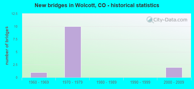
- New bridges - historical statistics
- 11960-1969
- 101970-1979
- 22000-2009


- Bridge Condition - Deck
- 12.5%Very good
- 37.5%Good
- 50.0%Satisfactory

- Bridge Condition - Superstructure
- 12.5%Very good
- 62.5%Good
- 25.0%Fair

- Bridge Condition - Substructure
- 50.0%Good
- 50.0%Satisfactory

- Bridge Condition - Channel
- 60.0%Very good
- 20.0%Good
- 20.0%Satisfactory
Find on map >> Show street view
Structure Number: F-10-A, Location: 2.5 MI N OF WOLCOTT (Lat: 39.729425, Lng: -106.678664), Route carried "on" structure: State highway 131B, Year Built: 1963, Status: Open, Structure Length: 0.79m (2.59ft), Average Daily Traffic: 1,600 (year 2020), Truck Traffic: 11%, Average Future Daily Traffic: 2,096 (year 2040), Design Load: HS 20, Features Intersected: ALKALI CREEK, Facility Carried by Structure: SH 131 ML
Minimum Vertical Clearance: 30+ m (98+ ft), Kilometerpoint: 3.951, Lanes on structure: 2, Base Highway Network: Yes, Owner: State Highway Agency, Approaching Roadway Width: 7.9m (25.9ft), Skew: 1 degrees, Material/Design: Concrete, Design/Construction: Culvert, Number Of Spans In Main Unit: 2, Length of Maximum Span: 3.7m (12.1ft), Out-to-Out Width: 10.8m (35.4ft)
Condition: Channel: Good, Culverts: Good, Operating Rating: 36.3 metric tons, Method Used To Determine Operating Rating: Field evaluation and documented engineering judgment, Inventory Rating: 32.7 metric tons, Method Used To Determine Inventory Rating: Field evaluation and documented engineering judgment, Structural Evaluation: Better than present minimum criteria, Waterway Adequacy: Equal to present minimum criteria, Approach Roadway Alignment: Equal to present desirable criteria, Designated Inspection Frequency: Every 24 months, Inspection Date: August 2020
Find on map >> Show street view
Structure Number: F-10-AA, Location: 4.6 MI W OF JCT SH 131 (Lat: 39.710817, Lng: -106.712203), Route carried "on" structure: Interstate 70A, Year Built: 1971, Status: Open, Structure Length: 34.32m (112.60ft), Average Daily Traffic: 14,500 (year 2020), Truck Traffic: 11%, Average Future Daily Traffic: 19,865 (year 2040), Design Load: HS 20+Mod, Features Intersected: US 6, RR, EAGLE RIVER, Facility Carried by Structure: I 70 ML WBND
Minimum Vertical Clearance: 30+ m (98+ ft), Kilometerpoint: 249.065, Lanes on structure: 2, Lanes under structure: 2, Base Highway Network: Yes, Owner: State Highway Agency, Approaching Roadway Width: 11.6m (38.1ft), Skew: 15 degrees, Material/Design: Steel continuous, Design/Construction: Stringer/Multi-beam, Number Of Spans In Main Unit: 7, Length of Maximum Span: 56.8m (186.4ft), Curb-To-Curb Width: 12.8m (42.0ft), Out-to-Out Width: 13.6m (44.6ft)
Condition: Deck: Satisfactory, Superstructure: Fair, Substructure: Satisfactory, Channel: Very good, Operating Rating: 49.0 metric tons, Method Used To Determine Operating Rating: Load Factor (LF), Inventory Rating: 29.0 metric tons, Method Used To Determine Inventory Rating: Load Factor (LF), Structural Evaluation: Somewhat better than minimum adequacy, Deck Geometry: Equal to present desirable criteria, Underclear: Equal to present desirable criteria, Waterway Adequacy: Superior to present desirable criteria, Approach Roadway Alignment: Equal to present desirable criteria, Length Of Structure Improvement: 34.33m (112.63ft), Designated Inspection Frequency: Every 24 months, Inspection Date: September 2020, Deck Structure Type: Concrete Cast-file-Place, Wearing Surface/Protective System: Wearing Surface: Bituminous, Membrane: Preformed Fabric
Find on map >> Show street view
Structure Number: F-10-AB, Location: 19.6 MI E OF GARFIELD C.L (Lat: 39.710567, Lng: -106.712525), Route carried "on" structure: Interstate 70A, Year Built: 1971, Status: Open, Structure Length: 34.32m (112.60ft), Average Daily Traffic: 14,500 (year 2020), Truck Traffic: 11%, Average Future Daily Traffic: 19,865 (year 2040), Design Load: HS 20+Mod, Features Intersected: US 6, RR, EAGLE RIVER, Facility Carried by Structure: I 70 ML EBND
Minimum Vertical Clearance: 30+ m (98+ ft), Kilometerpoint: 249.035, Lanes on structure: 2, Lanes under structure: 2, Base Highway Network: Yes, Owner: State Highway Agency, Approaching Roadway Width: 11.6m (38.1ft), Skew: 15 degrees, Material/Design: Steel continuous, Design/Construction: Stringer/Multi-beam, Number Of Spans In Main Unit: 7, Length of Maximum Span: 56.8m (186.4ft), Curb-To-Curb Width: 12.8m (42.0ft), Out-to-Out Width: 13.6m (44.6ft)
Condition: Deck: Satisfactory, Superstructure: Fair, Substructure: Good, Channel: Very good, Operating Rating: 50.1 metric tons, Method Used To Determine Operating Rating: Load Factor (LF), Inventory Rating: 30.0 metric tons, Method Used To Determine Inventory Rating: Load Factor (LF), Structural Evaluation: Somewhat better than minimum adequacy, Deck Geometry: Equal to present desirable criteria, Underclear: Superior to present desirable criteria, Waterway Adequacy: Equal to present desirable criteria, Approach Roadway Alignment: Equal to present desirable criteria, Length Of Structure Improvement: 34.33m (112.63ft), Designated Inspection Frequency: Every 24 months, Inspection Date: September 2020, Bridge Improvement Cost: $5,414,000, Roadway Improvement Cost: $541,000, Total Project Cost: $8,121,000, Deck Structure Type: Concrete Cast-file-Place, Wearing Surface/Protective System: Wearing Surface: Bituminous
Find on map >> Show street view
Structure Number: F-10-AC, Location: 6.5 MI E OF EAGLE (Lat: 39.703183, Lng: -106.727700), Route carried "on" structure: US 6E, Year Built: 2001, Status: Open, Structure Length: 4.77m (15.65ft), Average Daily Traffic: 3,400 (year 2020), Truck Traffic: 4%, Average Future Daily Traffic: 5,066 (year 2040), Design Load: HL 93, Features Intersected: EAGLE RIVER, Facility Carried by Structure: US 6 ML
Minimum Vertical Clearance: 30+ m (98+ ft), Kilometerpoint: 10.028, Lanes on structure: 2, Owner: State Highway Agency, Approaching Roadway Width: 11.6m (38.1ft), Skew: 2 degrees, Material/Design: Prestressed concrete, Design/Construction: Stringer/Multi-beam, Number Of Spans In Main Unit: 1, Length of Maximum Span: 46.8m (153.5ft), Curb-To-Curb Width: 12.0m (39.4ft), Out-to-Out Width: 12.9m (42.3ft)
Condition: Deck: Good, Superstructure: Good, Substructure: Good, Channel: Satisfactory, Operating Rating: 52.5 metric tons, Method Used To Determine Operating Rating: Load and Resistance Factor Rating (LRFR) rating reported by rating factor(RF) method using HL-93 loadings, Inventory Rating: 34.7 metric tons, Method Used To Determine Inventory Rating: Load and Resistance Factor Rating (LRFR) rating reported by rating factor(RF) method using HL-93 loadings, Structural Evaluation: Better than present minimum criteria, Deck Geometry: Somewhat better than minimum adequacy, Waterway Adequacy: Equal to present desirable criteria, Approach Roadway Alignment: Equal to present desirable criteria, Designated Inspection Frequency: Every 24 months, Inspection Date: July 2020, Deck Structure Type: Concrete Cast-file-Place, Wearing Surface/Protective System: Wearing Surface: Bituminous, Membrane: Preformed Fabric, Deck Protection: Epoxy Coated Reinforcing
Find on map >> Show street view
Structure Number: F-10-AD, Location: 3.6 MI W OF WOLCOTT INTER (Lat: 39.704175, Lng: -106.728789), Route carried "on" structure: Interstate 70A, Year Built: 1971, Status: Open, Structure Length: 2.60m (8.53ft), Average Daily Traffic: 14,500 (year 2020), Truck Traffic: 11%, Average Future Daily Traffic: 19,865 (year 2040), Design Load: HS 20+Mod, Features Intersected: COUNTY ROAD, Facility Carried by Structure: I 70 ML EBND
Minimum Vertical Clearance: 30+ m (98+ ft), Kilometerpoint: 247.441, Lanes on structure: 2, Lanes under structure: 1, Base Highway Network: Yes, Owner: State Highway Agency, Approaching Roadway Width: 11.6m (38.1ft), Skew: 13 degrees, Material/Design: Prestressed concrete, Design/Construction: Stringer/Multi-beam, Number Of Spans In Main Unit: 1, Length of Maximum Span: 24.4m (80.1ft), Curb-To-Curb Width: 12.8m (42.0ft), Out-to-Out Width: 13.6m (44.6ft)
Condition: Deck: Very good, Superstructure: Good, Substructure: Satisfactory, Operating Rating: 67.2 metric tons, Method Used To Determine Operating Rating: Load Factor (LF), Inventory Rating: 28.5 metric tons, Method Used To Determine Inventory Rating: Load Factor (LF), Structural Evaluation: Equal to present minimum criteria, Deck Geometry: Equal to present desirable criteria, Underclear: Meets minimum limits, Approach Roadway Alignment: Equal to present desirable criteria, Designated Inspection Frequency: Every 24 months, Inspection Date: August 2020, Deck Structure Type: Concrete Cast-file-Place, Wearing Surface/Protective System: Wearing Surface: Bituminous, Membrane: Preformed Fabric
Find on map >> Show street view
Structure Number: F-10-AH, Location: 0.7 MI N OF JCT I70 (Lat: 39.701364, Lng: -106.678025), Route carried "on" structure: State highway 131B, Year Built: 2005, Status: Open, Structure Length: 3.84m (12.60ft), Average Daily Traffic: 2,200 (year 2020), Truck Traffic: 15%, Average Future Daily Traffic: 2,596 (year 2040), Design Load: HS 25 or greater, Features Intersected: EAGLE RIVER, Facility Carried by Structure: SH 131 ML
Minimum Vertical Clearance: 30+ m (98+ ft), Kilometerpoint: 0.016, Lanes on structure: 2, Base Highway Network: Yes, Owner: State Highway Agency, Approaching Roadway Width: 8.5m (27.9ft), Skew: 1 degrees, Material/Design: Prestressed concrete, Design/Construction: Box Beam or Girders - Multiple, Number Of Spans In Main Unit: 1, Length of Maximum Span: 37.5m (123.0ft), Curb-To-Curb Width: 12.2m (40.0ft), Out-to-Out Width: 13.1m (43.0ft)
Condition: Deck: Good, Superstructure: Very good, Substructure: Good, Channel: Very good, Operating Rating: 63.5 metric tons, Method Used To Determine Operating Rating: Load Factor (LF), Inventory Rating: 24.5 metric tons, Method Used To Determine Inventory Rating: Load Factor (LF), Structural Evaluation: Equal to present minimum criteria, Deck Geometry: Equal to present minimum criteria, Waterway Adequacy: Equal to present desirable criteria, Approach Roadway Alignment: Better than present minimum criteria, Designated Inspection Frequency: Every 24 months, Inspection Date: August 2020, Deck Structure Type: Concrete Cast-file-Place, Wearing Surface/Protective System: Wearing Surface: Bituminous, Membrane: Built-up, Deck Protection: Epoxy Coated Reinforcing
Find on map >> Show street view
Structure Number: F-10-J, Location: WOLCOTT INTCHNG (Lat: 39.697333, Lng: -106.671742), Route carried "on" structure: Interstate 70A, Year Built: 1970, Status: Open, Structure Length: 4.39m (14.40ft), Average Daily Traffic: 14,500 (year 2020), Truck Traffic: 11%, Average Future Daily Traffic: 19,865 (year 2040), Design Load: HS 20+Mod, Features Intersected: SH 131 ML, Facility Carried by Structure: I 70 ML WBND
Minimum Vertical Clearance: 30+ m (98+ ft), Kilometerpoint: 253.261, Lanes on structure: 2, Lanes under structure: 2, Base Highway Network: Yes, Owner: State Highway Agency, Approaching Roadway Width: 11.6m (38.1ft), Skew: 10 degrees, Material/Design: Concrete continuous, Design/Construction: Tee Beam, Number Of Spans In Main Unit: 3, Length of Maximum Span: 17.7m (58.1ft), Curb-To-Curb Width: 12.8m (42.0ft), Out-to-Out Width: 13.6m (44.6ft)
Condition: Deck: Satisfactory, Superstructure: Good, Substructure: Satisfactory, Operating Rating: 49.9 metric tons, Method Used To Determine Operating Rating: Load Factor (LF), Inventory Rating: 30.0 metric tons, Method Used To Determine Inventory Rating: Load Factor (LF), Structural Evaluation: Equal to present minimum criteria, Deck Geometry: Equal to present desirable criteria, Underclear: Equal to present minimum criteria, Approach Roadway Alignment: Equal to present desirable criteria, Designated Inspection Frequency: Every 24 months, Inspection Date: August 2020, Deck Structure Type: Concrete Cast-file-Place, Wearing Surface/Protective System: Wearing Surface: Bituminous
Find on map >> Show street view
Structure Number: F-10-K, Location: WOLCOTT INTERCHANGE (Lat: 39.697150, Lng: -106.671903), Route carried "on" structure: Interstate 70A, Year Built: 1970, Status: Open, Structure Length: 4.39m (14.40ft), Average Daily Traffic: 14,500 (year 2020), Truck Traffic: 11%, Average Future Daily Traffic: 19,865 (year 2040), Design Load: HS 20+Mod, Features Intersected: SH 131 ML, Facility Carried by Structure: I 70 ML EBND
Minimum Vertical Clearance: 30+ m (98+ ft), Kilometerpoint: 253.259, Lanes on structure: 2, Lanes under structure: 2, Base Highway Network: Yes, Owner: State Highway Agency, Approaching Roadway Width: 11.6m (38.1ft), Skew: 10 degrees, Material/Design: Concrete continuous, Design/Construction: Tee Beam, Number Of Spans In Main Unit: 3, Length of Maximum Span: 18.0m (59.1ft), Curb-To-Curb Width: 12.8m (42.0ft), Out-to-Out Width: 13.5m (44.3ft)
Condition: Deck: Satisfactory, Superstructure: Good, Substructure: Good, Operating Rating: 49.9 metric tons, Method Used To Determine Operating Rating: Load Factor (LF), Inventory Rating: 30.0 metric tons, Method Used To Determine Inventory Rating: Load Factor (LF), Structural Evaluation: Better than present minimum criteria, Deck Geometry: Equal to present desirable criteria, Underclear: Equal to present minimum criteria, Approach Roadway Alignment: Equal to present desirable criteria, Designated Inspection Frequency: Every 24 months, Inspection Date: August 2020, Deck Structure Type: Concrete Cast-file-Place, Wearing Surface/Protective System: Wearing Surface: Bituminous
Find on map >> Show street view
Structure Number: F-10-X, Location: 3.6 MI W OF WOLCOTT INTER (Lat: 39.704439, Lng: -106.728867), Route carried "on" structure: Interstate 70A, Year Built: 1971, Status: Open, Structure Length: 2.60m (8.53ft), Average Daily Traffic: 14,500 (year 2020), Truck Traffic: 11%, Average Future Daily Traffic: 19,865 (year 2040), Design Load: HS 20+Mod, Features Intersected: COUNTY ROAD, Facility Carried by Structure: I 70 ML WBND
Minimum Vertical Clearance: 30+ m (98+ ft), Kilometerpoint: 247.456, Lanes on structure: 2, Lanes under structure: 1, Base Highway Network: Yes, Owner: State Highway Agency, Approaching Roadway Width: 11.6m (38.1ft), Skew: 13 degrees, Material/Design: Prestressed concrete, Design/Construction: Stringer/Multi-beam, Number Of Spans In Main Unit: 1, Length of Maximum Span: 24.4m (80.1ft), Curb-To-Curb Width: 12.8m (42.0ft), Out-to-Out Width: 13.6m (44.6ft)
Condition: Deck: Good, Superstructure: Good, Substructure: Satisfactory, Operating Rating: 67.2 metric tons, Method Used To Determine Operating Rating: Load Factor (LF), Inventory Rating: 28.5 metric tons, Method Used To Determine Inventory Rating: Load Factor (LF), Structural Evaluation: Equal to present minimum criteria, Deck Geometry: Equal to present desirable criteria, Underclear: Meets minimum limits, Approach Roadway Alignment: Equal to present desirable criteria, Designated Inspection Frequency: Every 24 months, Inspection Date: August 2020, Deck Structure Type: Concrete Cast-file-Place, Wearing Surface/Protective System: Wearing Surface: Bituminous, Membrane: Preformed Fabric
Find on map >> Show street view
Structure Number: F-10-AA, Location: 4.6 MI W OF JCT SH 131 (Lat: 39.710817, Lng: -106.712203), Route carried "under" structure: US 6E, Year Built: 1971, Structure Length: 0. m, Average Daily Traffic: 2,800 (year 2011), Truck Traffic: 6%, Features Intersected: US 6, RR, EAGLE RIVER, Facility Carried by Structure: I 70 ML WBND
Minimum Vertical Clearance: 5.13m (16.83ft), Kilometerpoint: 252.757, Lanes on structure: 2, Lanes under structure: 2, Material/Design: Steel continuous, Design/Construction: Stringer/Multi-beam, Length of Maximum Span: 56.8m (186.4ft)
Find on map >> Show street view
Structure Number: F-10-AB, Location: 19.6 MI E OF GARFIELD C.L (Lat: 39.710567, Lng: -106.712525), Route carried "under" structure: US 6E, Year Built: 1971, Structure Length: 0. m, Average Daily Traffic: 2,800 (year 2011), Truck Traffic: 6%, Features Intersected: US 6, RR, EAGLE RIVER, Facility Carried by Structure: I 70 ML EBND
Minimum Vertical Clearance: 5.74m (18.83ft), Kilometerpoint: 252.757, Lanes on structure: 2, Lanes under structure: 2, Material/Design: Steel continuous, Design/Construction: Stringer/Multi-beam, Length of Maximum Span: 56.8m (186.4ft)
Find on map >> Show street view
Structure Number: F-10-J, Location: WOLCOTT INTCHNG (Lat: 39.697333, Lng: -106.671742), Route carried "under" structure: State highway 131A, Year Built: 1970, Structure Length: 0. m, Average Daily Traffic: 4,700 (year 2011), Truck Traffic: 7%, Features Intersected: SH 131 ML, Facility Carried by Structure: I 70 ML WBND
Minimum Vertical Clearance: 5.16m (16.93ft), Kilometerpoint: 0.003, Lanes on structure: 2, Lanes under structure: 2, Material/Design: Concrete continuous, Design/Construction: Tee Beam, Length of Maximum Span: 17.7m (58.1ft)
Find on map >> Show street view
Structure Number: F-10-K, Location: WOLCOTT INTERCHANGE (Lat: 39.697150, Lng: -106.671903), Route carried "under" structure: State highway 131A, Year Built: 1970, Structure Length: 0. m, Average Daily Traffic: 4,700 (year 2011), Truck Traffic: 7%, Features Intersected: SH 131 ML, Facility Carried by Structure: I 70 ML EBND
Minimum Vertical Clearance: 16.85m (55.28ft), Kilometerpoint: 0.002, Lanes on structure: 2, Lanes under structure: 2, Material/Design: Concrete continuous, Design/Construction: Tee Beam, Length of Maximum Span: 18.0m (59.1ft)