Bridge Statistics for Wisconsin Dells, Wisconsin (WI)
Condition, Traffic, Stress, Structural Evaluation, Project Costs
- National Bridge Inventory (NBI) Statistics
- 15Number of bridges
- 213ft / 64.7mTotal length
- $2,302,000Total costs
- 214,351Total average daily traffic
- 32,375Total average daily truck traffic
- National Bridge Inventory (NBI) Registered Bridges for Wisconsin Dells
- No street view available for this location
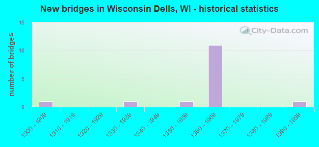
- New bridges - historical statistics
- 11900-1909
- 11930-1939
- 11950-1959
- 111960-1969
- 11990-1999

- Reconstructed bridges - Historical Statistics
- 21980-1989
- 31990-1999


- Bridge Condition - Deck
- 55.6%Good
- 33.3%Satisfactory
- 11.1%Poor

- Bridge Condition - Superstructure
- 55.6%Good
- 33.3%Satisfactory
- 11.1%Imminent failure

- Bridge Condition - Substructure
- 11.1%Good
- 33.3%Satisfactory
- 44.4%Fair
- 11.1%Imminent failure

- Bridge Condition - Channel
- 66.7%Very good
- 33.3%Satisfactory
Find on map >> Show street view
Structure Number: B110104, Location: 0.3M N JCT USH 12 (Lat: 43.627636, Lng: -89.781611), Route carried "on" structure: State highway 13, Year Built: 1991, Status: Open, Structure Length: 19.64m (64.44ft), Average Daily Traffic: 19,600 (year 2019), Truck Traffic: 3%, Average Future Daily Traffic: 22,700 (year 2037), Design Load: HS 20, Features Intersected: WISCONSIN RIVER 15
Minimum Vertical Clearance: 30+ m (98+ ft), Kilometerpoint: 0.000, Lanes on structure: 2, Owner: State Highway Agency, Approaching Roadway Width: 9.1m (29.9ft), Skew: 20 degrees, Material/Design: Steel, Design/Construction: Stringer/Multi-beam, Number Of Spans In Main Unit: 3, Length of Maximum Span: 74.7m (245.1ft), Curb-To-Curb Width: 9.1m (29.9ft), Out-to-Out Width: 10.5m (34.4ft)
Condition: Deck: Good, Superstructure: Good, Substructure: Good, Channel: Satisfactory, Operating Rating: 62.1 metric tons, Method Used To Determine Operating Rating: Load Factor (LF), Inventory Rating: 37.3 metric tons, Method Used To Determine Inventory Rating: Load Factor (LF), Structural Evaluation: Better than present minimum criteria, Deck Geometry: Meets minimum limits, Waterway Adequacy: Equal to present desirable criteria, Approach Roadway Alignment: Equal to present desirable criteria, Designated Inspection Frequency: Every 24 months, Underwater Inspection Frequency: Every 60 months, Inspection Date: April 2020, Underwater Inspection Date: May 2019, Deck Structure Type: Concrete Cast-file-Place, Wearing Surface/Protective System: Wearing Surface: Epoxy Overlay, Deck Protection: Epoxy Coated Reinforcing
Find on map >> Show street view
Structure Number: B290016, Location: 6.6M E JCT CTH HH (C) (Lat: 43.650033, Lng: -89.813369), Route carried "on" structure: Interstate 90, Year Built: 1964, Year Reconstructed: 2001, Status: Open, Structure Length: 4.23m (13.88ft), Average Daily Traffic: 18,750 (year 2019), Truck Traffic: 27%, Average Future Daily Traffic: 44,300 (year 2040), Design Load: HS 20, Features Intersected: USH 12-STH 16
Minimum Vertical Clearance: 30+ m (98+ ft), Kilometerpoint: 0.000, Lanes on structure: 2, Lanes under structure: 2, Base Highway Network: Yes, Owner: State Highway Agency, Approaching Roadway Width: 12.2m (40.0ft), Skew: 2 degrees, Material/Design: Prestressed concrete, Design/Construction: Stringer/Multi-beam, Number Of Spans In Main Unit: 3, Length of Maximum Span: 16.6m (54.5ft), Curb-To-Curb Width: 12.2m (40.0ft), Out-to-Out Width: 13.1m (43.0ft)
Condition: Deck: Good, Superstructure: Good, Substructure: Satisfactory, Operating Rating: 73.0 metric tons, Method Used To Determine Operating Rating: Load Factor (LF), Inventory Rating: 37.3 metric tons, Method Used To Determine Inventory Rating: Load Factor (LF), Structural Evaluation: Equal to present minimum criteria, Deck Geometry: Better than present minimum criteria, Underclear: High priority of replacement, Approach Roadway Alignment: Equal to present desirable criteria, Length Of Structure Improvement: 4.66m (15.29ft), Designated Inspection Frequency: Every 24 months, Inspection Date: April 2021, Bridge Improvement Cost: $581,000, Roadway Improvement Cost: $58,000, Total Project Cost: $872,000 ( Estimate for 2021), Deck Structure Type: Concrete Cast-file-Place, Wearing Surface/Protective System: Wearing Surface: Epoxy Overlay
Find on map >> Show street view
Structure Number: B290017, Location: 2.0M W JCT STH 13 (MP86) (Lat: 43.649453, Lng: -89.812933), Route carried "on" structure: Interstate 90, Year Built: 1964, Year Reconstructed: 2002, Status: Open, Structure Length: 4.23m (13.88ft), Average Daily Traffic: 18,750 (year 2019), Truck Traffic: 27%, Average Future Daily Traffic: 44,300 (year 2040), Design Load: HS 20, Features Intersected: USH 12-STH 16
Minimum Vertical Clearance: 30+ m (98+ ft), Kilometerpoint: 0.000, Lanes on structure: 2, Lanes under structure: 2, Base Highway Network: Yes, Owner: State Highway Agency, Approaching Roadway Width: 12.2m (40.0ft), Skew: 2 degrees, Material/Design: Prestressed concrete, Design/Construction: Stringer/Multi-beam, Number Of Spans In Main Unit: 3, Length of Maximum Span: 16.6m (54.5ft), Curb-To-Curb Width: 12.2m (40.0ft), Out-to-Out Width: 13.1m (43.0ft)
Condition: Deck: Good, Superstructure: Good, Substructure: Satisfactory, Operating Rating: 73.0 metric tons, Method Used To Determine Operating Rating: Load Factor (LF), Inventory Rating: 37.3 metric tons, Method Used To Determine Inventory Rating: Load Factor (LF), Structural Evaluation: Equal to present minimum criteria, Deck Geometry: Better than present minimum criteria, Underclear: High priority of replacement, Approach Roadway Alignment: Equal to present desirable criteria, Length Of Structure Improvement: 4.66m (15.29ft), Designated Inspection Frequency: Every 24 months, Inspection Date: April 2021, Bridge Improvement Cost: $581,000, Roadway Improvement Cost: $58,000, Total Project Cost: $872,000 ( Estimate for 2021), Deck Structure Type: Concrete Cast-file-Place, Wearing Surface/Protective System: Wearing Surface: Epoxy Overlay
Find on map >> Show street view
Structure Number: B290018, Location: 6.1M E JCT CTH HH (C) (Lat: 43.657122, Lng: -89.812289), Route carried "on" structure: Interstate 90, Year Built: 1964, Status: Open, Structure Length: 6.77m (22.21ft), Average Daily Traffic: 18,750 (year 2019), Truck Traffic: 27%, Average Future Daily Traffic: 31,400 (year 2040), Design Load: HS 20+Mod, Features Intersected: CP RR
Minimum Vertical Clearance: 30+ m (98+ ft), Kilometerpoint: 0.000, Lanes on structure: 2, Base Highway Network: Yes, Owner: State Highway Agency, Approaching Roadway Width: 12.2m (40.0ft), Skew: 4 degrees, Material/Design: Steel continuous, Design/Construction: Stringer/Multi-beam, Number Of Spans In Main Unit: 3, Length of Maximum Span: 25.3m (83.0ft), Curb-To-Curb Width: 12.2m (40.0ft), Out-to-Out Width: 13.1m (43.0ft)
Condition: Deck: Good, Superstructure: Good, Substructure: Fair, Operating Rating: 52.3 metric tons, Method Used To Determine Operating Rating: Load Factor (LF), Inventory Rating: 30.8 metric tons, Method Used To Determine Inventory Rating: Load Factor (LF), Structural Evaluation: Somewhat better than minimum adequacy, Deck Geometry: Better than present minimum criteria, Underclear: Better than present minimum criteria, Approach Roadway Alignment: Equal to present desirable criteria, Designated Inspection Frequency: Every 24 months, Inspection Date: April 2021, Deck Structure Type: Concrete Cast-file-Place, Wearing Surface/Protective System: Wearing Surface: Epoxy Overlay, Deck Protection: Epoxy Coated Reinforcing
Find on map >> Show street view
Structure Number: B290019, Location: 0.5M W JCT USH 12 (Lat: 43.656083, Lng: -89.811919), Route carried "on" structure: Interstate 90, Year Built: 1964, Status: Open, Structure Length: 6.77m (22.21ft), Average Daily Traffic: 18,750 (year 2019), Truck Traffic: 14%, Average Future Daily Traffic: 26,058 (year 2040), Design Load: HS 20+Mod, Features Intersected: CP RR
Minimum Vertical Clearance: 30+ m (98+ ft), Kilometerpoint: 0.000, Lanes on structure: 2, Base Highway Network: Yes, Owner: State Highway Agency, Approaching Roadway Width: 12.2m (40.0ft), Skew: 4 degrees, Material/Design: Steel continuous, Design/Construction: Stringer/Multi-beam, Number Of Spans In Main Unit: 3, Length of Maximum Span: 25.3m (83.0ft), Curb-To-Curb Width: 12.2m (40.0ft), Out-to-Out Width: 13.1m (43.0ft)
Condition: Deck: Good, Superstructure: Good, Substructure: Fair, Operating Rating: 52.3 metric tons, Method Used To Determine Operating Rating: Load Factor (LF), Inventory Rating: 30.8 metric tons, Method Used To Determine Inventory Rating: Load Factor (LF), Structural Evaluation: Somewhat better than minimum adequacy, Deck Geometry: Better than present minimum criteria, Underclear: Equal to present desirable criteria, Approach Roadway Alignment: Equal to present desirable criteria, Designated Inspection Frequency: Every 24 months, Inspection Date: April 2021, Deck Structure Type: Concrete Cast-file-Place, Wearing Surface/Protective System: Wearing Surface: Epoxy Overlay, Deck Protection: Epoxy Coated Reinforcing
Find on map >> Show street view
Structure Number: B56003, Location: 2.5M E JCT STH 23 (B) (Lat: 43.569678, Lng: -89.778842), Route carried "on" structure: Interstate 90, Year Built: 1960, Year Reconstructed: 1990, Status: Open, Structure Length: 5.96m (19.55ft), Average Daily Traffic: 20,900 (year 2019), Truck Traffic: 14%, Average Future Daily Traffic: 25,080 (year 2037), Design Load: HS 20, Features Intersected: USH 12
Minimum Vertical Clearance: 30+ m (98+ ft), Kilometerpoint: 0.000, Lanes on structure: 2, Lanes under structure: 6, Base Highway Network: Yes, Owner: State Highway Agency, Approaching Roadway Width: 12.8m (42.0ft), Material/Design: Prestressed concrete, Design/Construction: Stringer/Multi-beam, Number Of Spans In Main Unit: 4, Length of Maximum Span: 19.1m (62.7ft), Curb-To-Curb Width: 15.2m (49.9ft), Out-to-Out Width: 15.9m (52.2ft)
Condition: Deck: Satisfactory, Superstructure: Satisfactory, Substructure: Satisfactory, Operating Rating: 65.0 metric tons, Method Used To Determine Operating Rating: Load Factor (LF), Inventory Rating: 34.0 metric tons, Method Used To Determine Inventory Rating: Load Factor (LF), Structural Evaluation: Equal to present minimum criteria, Deck Geometry: Superior to present desirable criteria, Underclear: Somewhat better than minimum adequacy, Approach Roadway Alignment: Equal to present desirable criteria, Designated Inspection Frequency: Every 24 months, Inspection Date: August 2020, Deck Structure Type: Concrete Cast-file-Place, Wearing Surface/Protective System: Wearing Surface: Monolithic Concrete, Deck Protection: Epoxy Coated Reinforcing
Find on map >> Show street view
Structure Number: B560039, Location: 1.9M E JCT USH 12 TO CTH (Lat: 43.624728, Lng: -89.804653), Route carried "on" structure: Interstate 90, Year Built: 1961, Year Reconstructed: 1991, Status: Open, Structure Length: 8.54m (28.02ft), Average Daily Traffic: 21,850 (year 2018), Truck Traffic: 20%, Average Future Daily Traffic: 26,220 (year 2038), Design Load: HS 20, Features Intersected: STH 13
Minimum Vertical Clearance: 30+ m (98+ ft), Kilometerpoint: 0.000, Lanes on structure: 3, Lanes under structure: 3, Base Highway Network: Yes, Owner: State Highway Agency, Approaching Roadway Width: 15.2m (49.9ft), Material/Design: Steel continuous, Design/Construction: Stringer/Multi-beam, Number Of Spans In Main Unit: 3, Length of Maximum Span: 32.0m (105.0ft), Curb-To-Curb Width: 15.2m (49.9ft), Out-to-Out Width: 15.9m (52.2ft)
Condition: Deck: Satisfactory, Superstructure: Satisfactory, Substructure: Fair, Channel: Very good, Operating Rating: 53.9 metric tons, Method Used To Determine Operating Rating: Load Factor (LF), Inventory Rating: 32.4 metric tons, Method Used To Determine Inventory Rating: Load Factor (LF), Structural Evaluation: Somewhat better than minimum adequacy, Deck Geometry: Meets minimum limits, Underclear: Equal to present minimum criteria, Waterway Adequacy: Equal to present desirable criteria, Approach Roadway Alignment: Equal to present desirable criteria, Designated Inspection Frequency: Every 24 months, Inspection Date: May 2021, Deck Structure Type: Concrete Cast-file-Place, Wearing Surface/Protective System: Wearing Surface: Monolithic Concrete, Deck Protection: Epoxy Coated Reinforcing
Find on map >> Show street view
Structure Number: P110703, Location: 0.1M W JCT STH 113 (Lat: 43.316411, Lng: -89.531847), Route carried "on" structure: City street , Year Built: 1900, Status: Closed, Structure Length: 3.05m (10.01ft), Average Daily Traffic: 2,500 (year 2019), Average Future Daily Traffic: 2,500 (year 2038), Features Intersected: UNION PACIFIC RR, Facility Carried by Structure: LRD CHESTNUT ST
Minimum Vertical Clearance: 30+ m (98+ ft), Kilometerpoint: 0.000, Lanes on structure: 2, Owner: Railroad, Approaching Roadway Width: 11.0m (36.1ft), Material/Design: Steel, Design/Construction: Truss - Thru, Number Of Spans In Main Unit: 1, Number Of Approach Spans: 2, Length of Maximum Span: 13.8m (45.3ft), Curb-To-Curb Width: 4.9m (16.1ft), Out-to-Out Width: 5.3m (17.4ft)
Condition: Deck: Poor, Superstructure: Imminent failure, Substructure: Imminent failure, Underclear: Somewhat better than minimum adequacy, Approach Roadway Alignment: High priority of corrective action, Bridge Posting: Required (Relationship of Operating Rating to Maximum Legal Load: > 39.9% below), Length Of Structure Improvement: 3.51m (11.52ft), Designated Inspection Frequency: Every 12 months, Inspection Date: September 2019, Bridge Improvement Cost: $372,000, Roadway Improvement Cost: $37,000, Total Project Cost: $558,000 ( Estimate for 2021), Deck Structure Type: Wood or Timber, Wearing Surface/Protective System: Wearing Surface: Bituminous
Find on map >> Show street view
Structure Number: P110707, Location: 0.2M N JCT STH 13 (Lat: 43.631133, Lng: -89.774119), Route carried "on" structure: City street , Year Built: 1932, Year Reconstructed: 1988, Status: Open, Structure Length: 5.55m (18.21ft), Average Daily Traffic: 2,291 (year 2019), Average Future Daily Traffic: 2,520 (year 2039), Design Load: HS 20, Features Intersected: WISCONSIN RIVER TRIB, Facility Carried by Structure: LRD RIVER RD
Minimum Vertical Clearance: 30+ m (98+ ft), Kilometerpoint: 0.000, Lanes on structure: 2, Owner: City or Municipal Highway Agency, Approaching Roadway Width: 9.1m (29.9ft), Material/Design: Steel, Design/Construction: Stringer/Multi-beam, Number Of Spans In Main Unit: 3, Length of Maximum Span: 18.0m (59.1ft), Curb or Sidewalk Widths: Left: 2.2m (7.2ft), Right: 2.0m (6.6ft), Curb-To-Curb Width: 9.1m (29.9ft), Out-to-Out Width: 13.6m (44.6ft)
Condition: Deck: Satisfactory, Superstructure: Satisfactory, Substructure: Fair, Channel: Very good, Operating Rating: 49.0 metric tons, Method Used To Determine Operating Rating: Load Factor (LF), Inventory Rating: 29.2 metric tons, Method Used To Determine Inventory Rating: Load Factor (LF), Structural Evaluation: Somewhat better than minimum adequacy, Deck Geometry: Meets minimum limits, Waterway Adequacy: Equal to present desirable criteria, Approach Roadway Alignment: Equal to present desirable criteria, Designated Inspection Frequency: Every 24 months, Inspection Date: August 2020, Deck Structure Type: Concrete Cast-file-Place, Wearing Surface/Protective System: Wearing Surface: Monolithic Concrete, Deck Protection: Epoxy Coated Reinforcing
Find on map >> Show street view
Structure Number: B110005, Location: 0.4M N JCT USH 12 (Lat: 43.626667, Lng: -89.776667), Route carried "under" structure: State highway 13, Year Built: 1956, Structure Length: 0. m, Average Daily Traffic: 19,210 (year 2019), Features Intersected: STH 13/16/23-BROADWAY ST, Facility Carried by Structure: CMSTPP RR
Minimum Vertical Clearance: 4.54m (14.90ft), Kilometerpoint: 0.000, Lanes under structure: 2, Material/Design: Steel, Design/Construction: Truss - Deck, Length of Maximum Span: 50.3m (165.0ft)
Find on map >> Show street view
Structure Number: B290016, Location: 0.3M E JCT CTH J (C) (Lat: 43.650033, Lng: -89.813369), Route carried "under" structure: US 12, Year Built: 1964, Structure Length: 0. m, Average Daily Traffic: 3,700 (year 2019), Truck Traffic: 4%, Features Intersected: USH 12-STH 16, Facility Carried by Structure: IH 90 EB-IH 94 EB
Minimum Vertical Clearance: 5.06m (16.60ft), Kilometerpoint: 0.000, Lanes on structure: 2, Lanes under structure: 2, Material/Design: Prestressed concrete, Design/Construction: Stringer/Multi-beam, Length of Maximum Span: 16.6m (54.5ft)
Find on map >> Show street view
Structure Number: B290017, Location: 0.4M E JCT CTH J (C) (Lat: 43.649453, Lng: -89.812933), Route carried "under" structure: US 12, Year Built: 1964, Structure Length: 0. m, Average Daily Traffic: 3,700 (year 2019), Truck Traffic: 4%, Features Intersected: USH 12-STH 16, Facility Carried by Structure: IH 90 WB-IH 94 WB
Minimum Vertical Clearance: 4.94m (16.21ft), Kilometerpoint: 0.000, Lanes on structure: 2, Lanes under structure: 2, Material/Design: Prestressed concrete, Design/Construction: Stringer/Multi-beam, Length of Maximum Span: 16.6m (54.5ft)
Find on map >> Show street view
Structure Number: B29002, Location: 4.0M E JCT CTH HH TO W (Lat: 43.680717, Lng: -89.836911), Route carried "under" structure: Interstate 90, Year Built: 1964, Structure Length: 0. m, Average Daily Traffic: 35,200 (year 2019), Truck Traffic: 14%, Features Intersected: IH 90-IH 94, Facility Carried by Structure: LRD 63RD ST
Minimum Vertical Clearance: 4.80m (15.75ft), Kilometerpoint: 0.000, Lanes on structure: 2, Lanes under structure: 4, Material/Design: Steel continuous, Design/Construction: Stringer/Multi-beam, Length of Maximum Span: 23.3m (76.4ft)
Find on map >> Show street view
Structure Number: B560039, Location: 0.3M N JCT IH 90 TO E (Lat: 43.624728, Lng: -89.804653), Route carried "under" structure: State highway 13, Year Built: 1961, Structure Length: 0. m, Average Daily Traffic: 5,200 (year 2019), Truck Traffic: 14%, Features Intersected: STH 13, Facility Carried by Structure: IH 90 EB-IH 94 EB
Minimum Vertical Clearance: 4.62m (15.16ft), Kilometerpoint: 0.000, Lanes on structure: 3, Lanes under structure: 3, Material/Design: Steel continuous, Design/Construction: Stringer/Multi-beam, Length of Maximum Span: 32.0m (105.0ft)
Find on map >> Show street view
Structure Number: B56004, Location: 0.4M N JCT IH 90 TO E (Lat: 43.624081, Lng: -89.803803), Route carried "under" structure: State highway 13, Year Built: 1961, Structure Length: 0. m, Average Daily Traffic: 5,200 (year 2019), Truck Traffic: 14%, Features Intersected: STH 13 NB, Facility Carried by Structure: IH 90 WB-IH 94 WB
Minimum Vertical Clearance: 4.88m (16.01ft), Kilometerpoint: 0.000, Lanes on structure: 2, Lanes under structure: 3, Material/Design: Steel continuous, Design/Construction: Stringer/Multi-beam, Length of Maximum Span: 27.7m (90.9ft)