Bridge Statistics for Winter Park, Florida (FL)
Condition, Traffic, Stress, Structural Evaluation, Project Costs
- National Bridge Inventory (NBI) Statistics
- 10Number of bridges
- 75ft / 23.0mTotal length
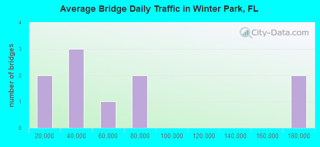
- 592,850Total average daily traffic
- 43,415Total average daily truck traffic
- National Bridge Inventory (NBI) Registered Bridges for Winter Park
- No street view available for this location
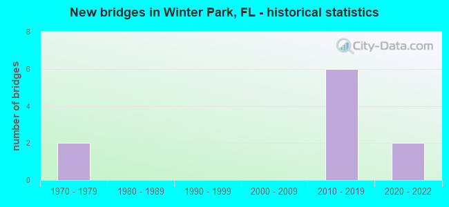
- New bridges - historical statistics
- 21970-1979
- 62010-2019
- 22020-2022
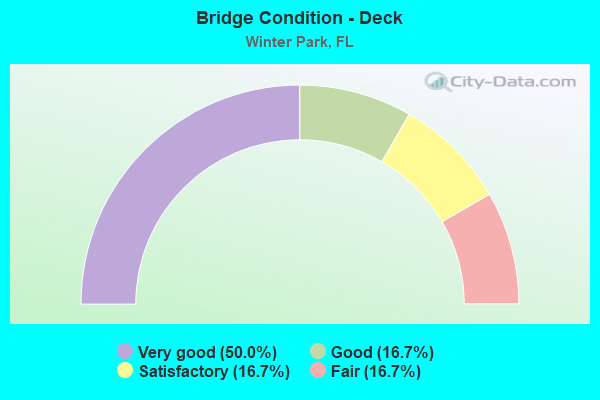
- Bridge Condition - Deck
- 50.0%Very good
- 16.7%Good
- 16.7%Satisfactory
- 16.7%Fair
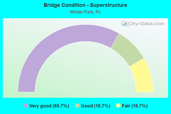
- Bridge Condition - Superstructure
- 66.7%Very good
- 16.7%Good
- 16.7%Fair
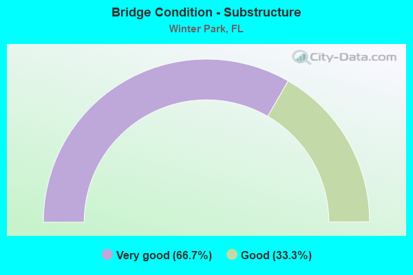
- Bridge Condition - Substructure
- 66.7%Very good
- 33.3%Good
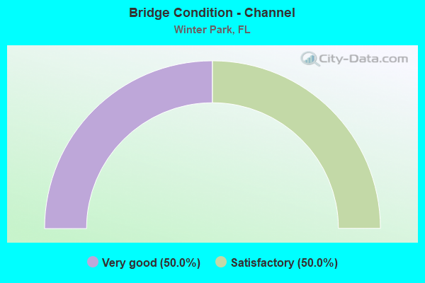
- Bridge Condition - Channel
- 50.0%Very good
- 50.0%Satisfactory
Find on map >> Show street view
Structure Number: 750085, Location: SR-426 - Fern Canal (Lat: 28.595692, Lng: -81.342236), Route carried "on" structure: State highway 426, Year Built: 1971, Status: Open, Structure Length: 1.17m (3.84ft), Average Daily Traffic: 36,500 (year 2020), Truck Traffic: 2%, Average Future Daily Traffic: 63,328 (year 2042), Design Load: HS 20, Features Intersected: Fern Canal
Minimum Vertical Clearance: 30+ m (98+ ft), Kilometerpoint: 0.900, Lanes on structure: 4, Base Highway Network: Yes, Owner: State Highway Agency, Approaching Roadway Width: 14.6m (47.9ft), Skew: 1 degrees, Material/Design: Prestressed concrete, Design/Construction: Slab, Number Of Spans In Main Unit: 1, Length of Maximum Span: 11.1m (36.4ft), Curb or Sidewalk Widths: Left: 1.5m (4.9ft), Right: 1.5m (4.9ft), Curb-To-Curb Width: 14.6m (47.9ft), Out-to-Out Width: 18.3m (60.0ft)
Condition: Deck: Fair, Superstructure: Fair, Substructure: Good, Channel: Very good, Operating Rating: 81.5 metric tons, Method Used To Determine Operating Rating: Load Factor (LF), Inventory Rating: 48.8 metric tons, Method Used To Determine Inventory Rating: Load Factor (LF), Structural Evaluation: Somewhat better than minimum adequacy, Deck Geometry: High priority of replacement, Waterway Adequacy: Equal to present desirable criteria, Approach Roadway Alignment: Better than present minimum criteria, Designated Inspection Frequency: Every 24 months, Underwater Inspection Frequency: Every 24 months, Inspection Date: September 2021, Underwater Inspection Date: September 2021, Deck Structure Type: Concrete Precast Panels, Wearing Surface/Protective System: Wearing Surface: Bituminous
Find on map >> Show street view
Structure Number: 750898, Location: EB 0.4mi N of SR 426 (Lat: 28.598167, Lng: -81.385722), Route carried "on" structure: Interstate 4, Year Built: 2018, Status: Open, Structure Length: 4.88m (16.01ft), Average Daily Traffic: 61,000 (year 2020), Truck Traffic: 7%, Average Future Daily Traffic: 105,835 (year 2040), Design Load: HL 93, Features Intersected: Wymore Road
Minimum Vertical Clearance: 4.63m (15.19ft), Kilometerpoint: 34.842, Lanes on structure: 6, Lanes under structure: 2, Base Highway Network: Yes, Owner: State Highway Agency, Approaching Roadway Width: 29.9m (98.1ft), Skew: 35 degrees, Material/Design: Prestressed concrete, Design/Construction: Stringer/Multi-beam, Number Of Spans In Main Unit: 1, Length of Maximum Span: 48.8m (160.1ft), Curb-To-Curb Width: 29.9m (98.1ft), Out-to-Out Width: 36.3m (119.1ft)
Condition: Deck: Satisfactory, Superstructure: Very good, Substructure: Very good, Operating Rating: 38.8 metric tons, Method Used To Determine Operating Rating: Load and Resistance Factor (LRFR), Inventory Rating: 34.9 metric tons, Method Used To Determine Inventory Rating: Load and Resistance Factor (LRFR), Structural Evaluation: Equal to present desirable criteria, Deck Geometry: Superior to present desirable criteria, Underclear: Equal to present minimum criteria, Approach Roadway Alignment: Equal to present desirable criteria, Designated Inspection Frequency: Every 24 months, Inspection Date: August 2020, Deck Structure Type: Concrete Cast-file-Place
Find on map >> Show street view
Structure Number: 750901, Location: 3.0MI N/O US-17 (Lat: 28.593111, Lng: -81.382000), Route carried "on" structure: Interstate 4, Year Built: 2020, Status: Open, Structure Length: 5.22m (17.13ft), Average Daily Traffic: 160,200 (year 2020), Truck Traffic: 7%, Average Future Daily Traffic: 202,700 (year 2040), Design Load: HL 93, Features Intersected: SR-426 (Fairbanks Ave)
Minimum Vertical Clearance: 30.18m (99.02ft), Kilometerpoint: 34.279, Lanes on structure: 6, Lanes under structure: 6, Base Highway Network: Yes, Owner: State Highway Agency, Approaching Roadway Width: 32.3m (106.0ft), Skew: 34 degrees, Material/Design: Prestressed concrete, Design/Construction: Stringer/Multi-beam, Number Of Spans In Main Unit: 1, Length of Maximum Span: 52.2m (171.3ft), Curb-To-Curb Width: 32.3m (106.0ft), Out-to-Out Width: 33.9m (111.2ft)
Condition: Deck: Very good, Superstructure: Very good, Substructure: Very good, Operating Rating: 36.9 metric tons, Method Used To Determine Operating Rating: Load and Resistance Factor (LRFR), Inventory Rating: 33.3 metric tons, Method Used To Determine Inventory Rating: Load and Resistance Factor (LRFR), Structural Evaluation: Equal to present desirable criteria, Deck Geometry: Superior to present desirable criteria, Underclear: Equal to present minimum criteria, Approach Roadway Alignment: Equal to present desirable criteria, Designated Inspection Frequency: Every 24 months, Inspection Date: May 2020, Deck Structure Type: Concrete Cast-file-Place
Find on map >> Show street view
Structure Number: 750902, Location: EB 3mi N of US-17 (Lat: 28.593111, Lng: -81.381733), Route carried "on" structure: Interstate 4, Year Built: 2018, Status: Open, Structure Length: 5.18m (16.99ft), Average Daily Traffic: 76,250 (year 2020), Truck Traffic: 7%, Average Future Daily Traffic: 132,294 (year 2040), Design Load: HL 93, Features Intersected: SR 426 (Fairbanks Ave)
Minimum Vertical Clearance: 30.18m (99.02ft), Kilometerpoint: 34.279, Lanes on structure: 6, Lanes under structure: 6, Base Highway Network: Yes, Owner: State Highway Agency, Approaching Roadway Width: 32.3m (106.0ft), Skew: 34 degrees, Material/Design: Prestressed concrete, Design/Construction: Stringer/Multi-beam, Number Of Spans In Main Unit: 1, Length of Maximum Span: 51.8m (169.9ft), Curb-To-Curb Width: 32.3m (106.0ft), Out-to-Out Width: 33.9m (111.2ft)
Condition: Deck: Very good, Superstructure: Very good, Substructure: Very good, Operating Rating: 49.6 metric tons, Method Used To Determine Operating Rating: Load and Resistance Factor (LRFR), Inventory Rating: 45.1 metric tons, Method Used To Determine Inventory Rating: Load and Resistance Factor (LRFR), Structural Evaluation: Equal to present desirable criteria, Deck Geometry: Superior to present desirable criteria, Underclear: Equal to present minimum criteria, Approach Roadway Alignment: Equal to present desirable criteria, Designated Inspection Frequency: Every 24 months, Inspection Date: October 2020, Deck Structure Type: Concrete Cast-file-Place
Find on map >> Show street view
Structure Number: 750903, Location: 1 mile N of SR 426 (Lat: 28.605889, Lng: -81.386500), Route carried "on" structure: Interstate 4, Year Built: 2018, Status: Open, Structure Length: 5.14m (16.86ft), Average Daily Traffic: 160,200 (year 2020), Truck Traffic: 10%, Average Future Daily Traffic: 202,700 (year 2040), Design Load: HL 93, Features Intersected: SR 423 (Lee Road)
Minimum Vertical Clearance: 30.18m (99.02ft), Kilometerpoint: 35.727, Lanes on structure: 10, Lanes under structure: 8, Base Highway Network: Yes, Owner: State Highway Agency, Approaching Roadway Width: 57.6m (189.0ft), Skew: 32 degrees, Material/Design: Prestressed concrete, Design/Construction: Stringer/Multi-beam, Number Of Spans In Main Unit: 1, Length of Maximum Span: 51.4m (168.6ft), Curb-To-Curb Width: 57.6m (189.0ft), Out-to-Out Width: 60.4m (198.2ft)
Condition: Deck: Very good, Superstructure: Very good, Substructure: Very good, Operating Rating: 36.6 metric tons, Method Used To Determine Operating Rating: Load and Resistance Factor (LRFR), Inventory Rating: 33.7 metric tons, Method Used To Determine Inventory Rating: Load and Resistance Factor (LRFR), Structural Evaluation: Equal to present desirable criteria, Deck Geometry: Superior to present desirable criteria, Underclear: Equal to present minimum criteria, Approach Roadway Alignment: Equal to present desirable criteria, Designated Inspection Frequency: Every 24 months, Inspection Date: October 2020, Deck Structure Type: Concrete Cast-file-Place
Find on map >> Show street view
Structure Number: 754064, Location: 0.2 Mile N. of Howell Br. (Lat: 28.626872, Lng: -81.338778), Route carried "on" structure: County highway , Year Built: 1979, Status: Open, Structure Length: 1.37m (4.49ft), Average Daily Traffic: 6,200 (year 2021), Truck Traffic: 5%, Average Future Daily Traffic: 7,555 (year 2042), Design Load: HS 20, Features Intersected: Howell Branch Creek, Facility Carried by Structure: Temple Trail
Minimum Vertical Clearance: 30+ m (98+ ft), Kilometerpoint: 2.288, Lanes on structure: 2, Owner: City or Municipal Highway Agency, Approaching Roadway Width: 8.0m (26.2ft), Material/Design: Prestressed concrete, Design/Construction: Slab, Number Of Spans In Main Unit: 1, Length of Maximum Span: 13.7m (44.9ft), Curb or Sidewalk Widths: Left: 1.5m (4.9ft), Right: 0.0m, Curb-To-Curb Width: 8.6m (28.2ft), Out-to-Out Width: 11.1m (36.4ft)
Condition: Deck: Good, Superstructure: Good, Substructure: Good, Channel: Satisfactory, Operating Rating: 59.1 metric tons, Method Used To Determine Operating Rating: Allowable Stress (AS), Inventory Rating: 51.4 metric tons, Method Used To Determine Inventory Rating: Allowable Stress (AS), Structural Evaluation: Better than present minimum criteria, Deck Geometry: High priority of replacement, Waterway Adequacy: Equal to present minimum criteria, Approach Roadway Alignment: High priority of replacement, Designated Inspection Frequency: Every 24 months, Inspection Date: October 2021, Deck Structure Type: Concrete Precast Panels, Wearing Surface/Protective System: Wearing Surface: Bituminous
Find on map >> Show street view
Structure Number: 750898, Location: EB 0.4mi N of SR 426 (Lat: 28.598167, Lng: -81.385722), Route carried "under" structure: City street , Year Built: 2018, Structure Length: 0. m, Average Daily Traffic: 9,000 (year 2020), Truck Traffic: 1%, Features Intersected: Wymore Road, Facility Carried by Structure: I-4
Minimum Vertical Clearance: 4.63m (15.19ft), Kilometerpoint: 0.241, Lanes on structure: 6, Lanes under structure: 2, Material/Design: Prestressed concrete, Design/Construction: Stringer/Multi-beam, Length of Maximum Span: 48.8m (160.1ft)
Find on map >> Show street view
Structure Number: 750901, Location: 3.0MI N/O US-17 (Lat: 28.593111, Lng: -81.382000), Route carried "under" structure: State highway 426, Year Built: 2020, Structure Length: 0. m, Average Daily Traffic: 20,750 (year 2020), Truck Traffic: 3%, Features Intersected: SR-426 (Fairbanks Ave), Facility Carried by Structure: I-4 WB
Minimum Vertical Clearance: 5.00m (16.40ft), Kilometerpoint: 0.805, Lanes on structure: 6, Lanes under structure: 6, Material/Design: Prestressed concrete, Design/Construction: Stringer/Multi-beam, Length of Maximum Span: 52.2m (171.3ft)
Find on map >> Show street view
Structure Number: 750902, Location: EB 3mi N of US-17 (Lat: 28.593111, Lng: -81.381733), Route carried "under" structure: State highway 426, Year Built: 2018, Structure Length: 0. m, Average Daily Traffic: 20,750 (year 2020), Truck Traffic: 3%, Features Intersected: SR 426 (Fairbanks Ave), Facility Carried by Structure: I-4 (SR 400)
Minimum Vertical Clearance: 5.00m (16.40ft), Kilometerpoint: 0.805, Lanes on structure: 6, Lanes under structure: 6, Material/Design: Prestressed concrete, Design/Construction: Stringer/Multi-beam, Length of Maximum Span: 51.8m (169.9ft)
Find on map >> Show street view
Structure Number: 750903, Location: 1 mile N of SR 426 (Lat: 28.605889, Lng: -81.386500), Route carried "under" structure: State highway 423, Year Built: 2018, Structure Length: 0. m, Average Daily Traffic: 42,000 (year 2020), Truck Traffic: 10%, Features Intersected: SR 423 (Lee Road), Facility Carried by Structure: I-4 (SR 400)
Minimum Vertical Clearance: 5.03m (16.50ft), Kilometerpoint: 13.679, Lanes on structure: 10, Lanes under structure: 8, Material/Design: Prestressed concrete, Design/Construction: Stringer/Multi-beam, Length of Maximum Span: 51.4m (168.6ft)