Bridge Statistics for Winter Haven, Florida (FL)
Condition, Traffic, Stress, Structural Evaluation, Project Costs
- National Bridge Inventory (NBI) Statistics
- 24Number of bridges
- 243ft / 74.1mTotal length
- 314,315Total average daily traffic
- 35,935Total average daily truck traffic
- National Bridge Inventory (NBI) Registered Bridges for Winter Haven
- No street view available for this location
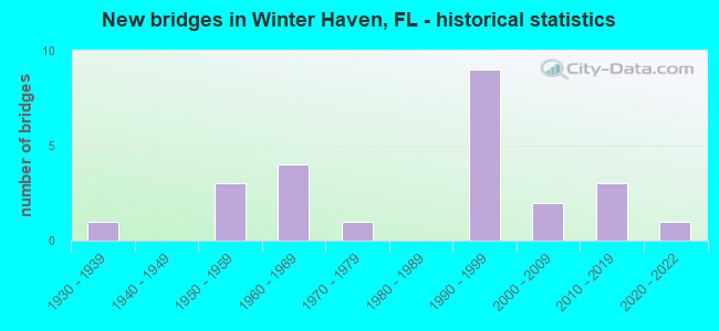
- New bridges - historical statistics
- 11930-1939
- 31950-1959
- 41960-1969
- 11970-1979
- 91990-1999
- 22000-2009
- 32010-2019
- 12020-2022
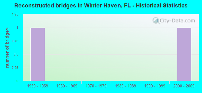
- Reconstructed bridges - Historical Statistics
- 11950-1959
- 01960-1969
- 01970-1979
- 01980-1989
- 01990-1999
- 12000-2009
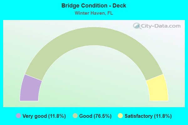
- Bridge Condition - Deck
- 11.8%Very good
- 76.5%Good
- 11.8%Satisfactory
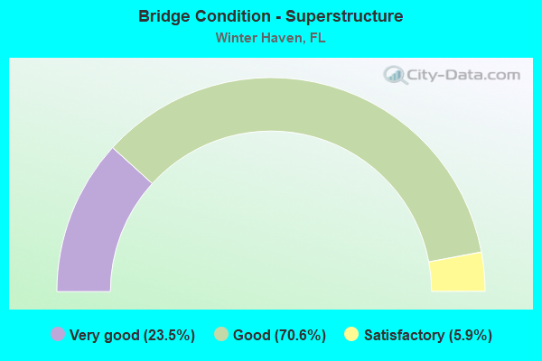
- Bridge Condition - Superstructure
- 23.5%Very good
- 70.6%Good
- 5.9%Satisfactory
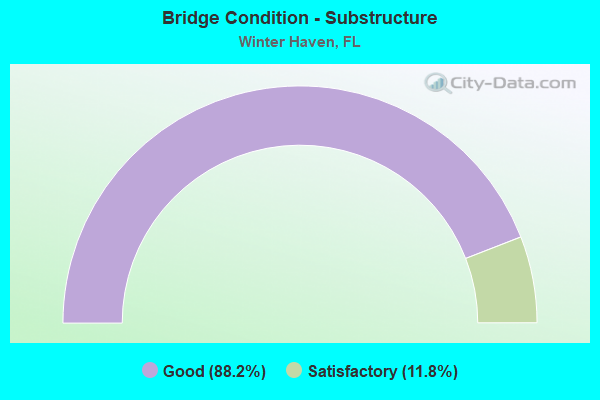
- Bridge Condition - Substructure
- 88.2%Good
- 11.8%Satisfactory
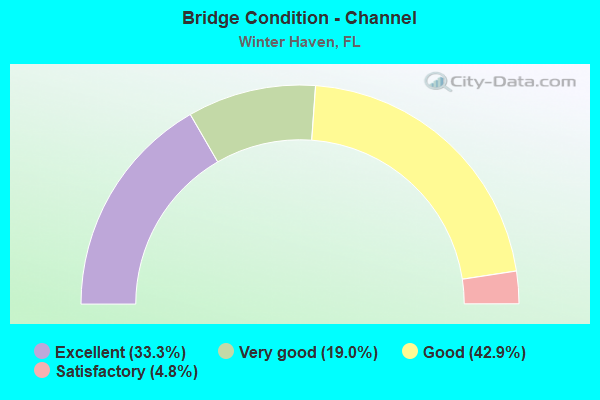
- Bridge Condition - Channel
- 33.3%Excellent
- 19.0%Very good
- 42.9%Good
- 4.8%Satisfactory
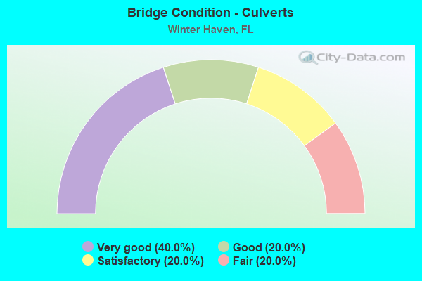
- Bridge Condition - Culverts
- 40.0%Very good
- 20.0%Good
- 20.0%Satisfactory
- 20.0%Fair
Find on map >> Show street view
Structure Number: 160042, Location: 0.7 MI EAST OF US-17 (Lat: 27.902328, Lng: -81.817625), Route carried "on" structure: State highway 60, Year Built: 1964, Status: Open, Structure Length: 15.85m (52.00ft), Average Daily Traffic: 11,750 (year 2020), Truck Traffic: 22%, Average Future Daily Traffic: 20,386 (year 2042), Design Load: HS 20, Features Intersected: PEACE RIVER
Minimum Vertical Clearance: 30+ m (98+ ft), Kilometerpoint: 24.961, Lanes on structure: 2, Base Highway Network: Yes, Owner: State Highway Agency, Approaching Roadway Width: 8.7m (28.5ft), Material/Design: Prestressed concrete, Design/Construction: Stringer/Multi-beam, Number Of Spans In Main Unit: 13, Length of Maximum Span: 12.2m (40.0ft), Curb-To-Curb Width: 8.7m (28.5ft), Out-to-Out Width: 10.4m (34.1ft)
Condition: Deck: Good, Superstructure: Very good, Substructure: Good, Channel: Good, Inventory Rating: 54.4 metric tons, Method Used To Determine Inventory Rating: Load Factor (LF), Structural Evaluation: Better than present minimum criteria, Deck Geometry: High priority of corrective action, Waterway Adequacy: Equal to present desirable criteria, Approach Roadway Alignment: Equal to present desirable criteria, Designated Inspection Frequency: Every 24 months, Underwater Inspection Frequency: Every 24 months, Inspection Date: October 2020, Underwater Inspection Date: September 2020, Deck Structure Type: Concrete Cast-file-Place
Find on map >> Show street view
Structure Number: 160084, Location: 0.2 MI SOUTH OF US-92 (Lat: 28.072581, Lng: -81.732675), Route carried "on" structure: US 17, Year Built: 1934, Year Reconstructed: 1964, Status: Open, Structure Length: 0.82m (2.69ft), Average Daily Traffic: 24,000 (year 2020), Truck Traffic: 9%, Average Future Daily Traffic: 41,640 (year 2042), Design Load: H 20, Features Intersected: GRAVEL CREEK
Minimum Vertical Clearance: 6.40m (21.00ft), Kilometerpoint: 52.492, Lanes on structure: 4, Base Highway Network: Yes, Owner: State Highway Agency, Approaching Roadway Width: 21.9m (71.9ft), Skew: 23 degrees, Material/Design: Concrete, Design/Construction: Culvert, Number Of Spans In Main Unit: 2, Length of Maximum Span: 3.7m (12.1ft)
Condition: Channel: Satisfactory, Culverts: Fair, Operating Rating: 75.7 metric tons, Method Used To Determine Operating Rating: Load Factor (LF), Inventory Rating: 45.4 metric tons, Method Used To Determine Inventory Rating: Load Factor (LF), Structural Evaluation: Somewhat better than minimum adequacy, Waterway Adequacy: Somewhat better than minimum adequacy, Approach Roadway Alignment: Equal to present desirable criteria, Designated Inspection Frequency: Every 24 months, Underwater Inspection Frequency: Every 24 months, Inspection Date: September 2020, Underwater Inspection Date: August 2020
Find on map >> Show street view
Structure Number: 160096, Location: 1.1 MI. WEST OF US-17 (Lat: 28.032403, Lng: -81.748394), Route carried "on" structure: County highway 542, Year Built: 1955, Status: Open, Structure Length: 2.28m (7.48ft), Average Daily Traffic: 10,100 (year 2020), Truck Traffic: 14%, Average Future Daily Traffic: 17,524 (year 2042), Features Intersected: LAKE HOWARD CANAL
Minimum Vertical Clearance: 30+ m (98+ ft), Kilometerpoint: 19.920, Lanes on structure: 2, Owner: City or Municipal Highway Agency, Approaching Roadway Width: 8.5m (27.9ft), Material/Design: Concrete, Design/Construction: Tee Beam, Number Of Spans In Main Unit: 3, Length of Maximum Span: 7.6m (24.9ft), Curb or Sidewalk Widths: Left: 1.5m (4.9ft), Right: 1.6m (5.2ft), Curb-To-Curb Width: 8.5m (27.9ft), Out-to-Out Width: 12.1m (39.7ft)
Condition: Deck: Satisfactory, Superstructure: Good, Substructure: Good, Channel: Very good, Operating Rating: 60.1 metric tons, Method Used To Determine Operating Rating: Load Factor (LF), Inventory Rating: 35.9 metric tons, Method Used To Determine Inventory Rating: Load Factor (LF), Structural Evaluation: Better than present minimum criteria, Deck Geometry: High priority of replacement, Waterway Adequacy: Equal to present desirable criteria, Approach Roadway Alignment: Somewhat better than minimum adequacy, Designated Inspection Frequency: Every 24 months, Inspection Date: Febuary 2022, Deck Structure Type: Concrete Cast-file-Place
Find on map >> Show street view
Structure Number: 160136, Location: 1.8 MI SE OF JCT US-92 (Lat: 28.046181, Lng: -81.755669), Route carried "on" structure: State highway 544, Year Built: 1972, Status: Open, Structure Length: 1.86m (6.10ft), Average Daily Traffic: 29,500 (year 2020), Truck Traffic: 8%, Average Future Daily Traffic: 51,182 (year 2042), Design Load: HS 20, Features Intersected: HAVENDALE CANAL
Minimum Vertical Clearance: 30+ m (98+ ft), Kilometerpoint: 3.042, Lanes on structure: 6, Base Highway Network: Yes, Owner: State Highway Agency, Approaching Roadway Width: 23.8m (78.1ft), Skew: 20 degrees, Material/Design: Prestressed concrete, Design/Construction: Stringer/Multi-beam, Number Of Spans In Main Unit: 1, Length of Maximum Span: 18.6m (61.0ft), Curb or Sidewalk Widths: Left: 1.5m (4.9ft), Right: 1.5m (4.9ft), Curb-To-Curb Width: 23.8m (78.1ft), Out-to-Out Width: 31.1m (102.0ft)
Condition: Deck: Good, Superstructure: Good, Substructure: Good, Channel: Very good, Operating Rating: 54.4 metric tons, Method Used To Determine Operating Rating: Allowable Stress (AS), Inventory Rating: 48.1 metric tons, Method Used To Determine Inventory Rating: Allowable Stress (AS), Structural Evaluation: Better than present minimum criteria, Deck Geometry: Somewhat better than minimum adequacy, Waterway Adequacy: Equal to present desirable criteria, Approach Roadway Alignment: Equal to present desirable criteria, Designated Inspection Frequency: Every 24 months, Underwater Inspection Frequency: Every 24 months, Inspection Date: July 2020, Underwater Inspection Date: June 2020, Deck Structure Type: Concrete Cast-file-Place
Find on map >> Show street view
Structure Number: 160156, Location: 3.4 MI WEST OF US-27 (Lat: 28.022456, Lng: -81.684617), Route carried "on" structure: State highway 542, Year Built: 1951, Status: Open, Structure Length: 0.64m (2.10ft), Average Daily Traffic: 14,100 (year 2020), Truck Traffic: 7%, Average Future Daily Traffic: 24,464 (year 2042), Design Load: H 15, Features Intersected: EASTWOOD DRAIN
Minimum Vertical Clearance: 30+ m (98+ ft), Kilometerpoint: 4.881, Lanes on structure: 2, Owner: State Highway Agency, Approaching Roadway Width: 9.8m (32.2ft), Material/Design: Concrete, Design/Construction: Culvert, Number Of Spans In Main Unit: 2, Length of Maximum Span: 3.2m (10.5ft)
Condition: Channel: Excellent, Culverts: Good, Operating Rating: 49.9 metric tons, Method Used To Determine Operating Rating: Load Factor (LF), Inventory Rating: 29.9 metric tons, Method Used To Determine Inventory Rating: Load Factor (LF), Structural Evaluation: Better than present minimum criteria, Waterway Adequacy: Equal to present desirable criteria, Approach Roadway Alignment: Equal to present desirable criteria, Designated Inspection Frequency: Every 24 months, Inspection Date: August 2020
Find on map >> Show street view
Structure Number: 160202, Location: 0.8 MI. SOUTH OF SR-544 (Lat: 28.073097, Lng: -81.645847), Route carried "on" structure: US 27, Year Built: 1958, Year Reconstructed: 2012, Status: Open, Structure Length: 0.68m (2.23ft), Average Daily Traffic: 38,500 (year 2020), Truck Traffic: 11%, Average Future Daily Traffic: 66,798 (year 2042), Design Load: HS 20, Features Intersected: LAKE HAMILTON CREEK
Minimum Vertical Clearance: 30+ m (98+ ft), Kilometerpoint: 20.400, Lanes on structure: 6, Base Highway Network: Yes, Owner: State Highway Agency, Approaching Roadway Width: 24.7m (81.0ft), Skew: 1 degrees, Material/Design: Concrete, Design/Construction: Culvert, Number Of Spans In Main Unit: 2, Length of Maximum Span: 3.3m (10.8ft)
Condition: Channel: Good, Culverts: Satisfactory, Operating Rating: 67.1 metric tons, Method Used To Determine Operating Rating: Load Factor (LF), Inventory Rating: 40.8 metric tons, Method Used To Determine Inventory Rating: Load Factor (LF), Structural Evaluation: Equal to present minimum criteria, Waterway Adequacy: Equal to present desirable criteria, Approach Roadway Alignment: Equal to present desirable criteria, Designated Inspection Frequency: Every 24 months, Underwater Inspection Frequency: Every 24 months, Inspection Date: Febuary 2022, Underwater Inspection Date: January 2022
Find on map >> Show street view
Structure Number: 16022, Location: 0.5 MI SOUTH OF SR-540 (Lat: 27.998122, Lng: -81.734775), Route carried "on" structure: US 17, Year Built: 1995, Status: Open, Structure Length: 6.64m (21.78ft), Average Daily Traffic: 37,000 (year 2020), Truck Traffic: 7%, Average Future Daily Traffic: 64,195 (year 2042), Design Load: HS 20+Mod, Features Intersected: CSX RR & LK SHIPP CANAL
Minimum Vertical Clearance: 30+ m (98+ ft), Kilometerpoint: 43.919, Lanes on structure: 6, Base Highway Network: Yes, Owner: State Highway Agency, Approaching Roadway Width: 31.5m (103.3ft), Skew: 29 degrees, Material/Design: Prestressed concrete, Design/Construction: Stringer/Multi-beam, Number Of Spans In Main Unit: 3, Length of Maximum Span: 28.7m (94.2ft), Curb or Sidewalk Widths: Left: 1.6m (5.2ft), Right: 1.6m (5.2ft), Curb-To-Curb Width: 31.5m (103.3ft), Out-to-Out Width: 35.9m (117.8ft)
Condition: Deck: Very good, Superstructure: Very good, Substructure: Good, Channel: Excellent, Operating Rating: 66.7 metric tons, Method Used To Determine Operating Rating: Load Factor (LF), Inventory Rating: 39.9 metric tons, Method Used To Determine Inventory Rating: Load Factor (LF), Structural Evaluation: Better than present minimum criteria, Deck Geometry: Superior to present desirable criteria, Underclear: Superior to present desirable criteria, Waterway Adequacy: Equal to present desirable criteria, Approach Roadway Alignment: Equal to present desirable criteria, Designated Inspection Frequency: Every 24 months, Inspection Date: October 2020, Deck Structure Type: Concrete Cast-file-Place
Find on map >> Show street view
Structure Number: 160276, Location: 6.4MI W OF I-4 E INTRCHNG (Lat: 28.073569, Lng: -81.832508), Route carried "on" structure: State highway 570, Year Built: 1999, Status: Open, Structure Length: 4.82m (15.81ft), Average Daily Traffic: 10,700 (year 2020), Truck Traffic: 17%, Average Future Daily Traffic: 18,564 (year 2042), Design Load: HS 20, Features Intersected: CR 546 OLD DIXIE HIGHWAY
Minimum Vertical Clearance: 30+ m (98+ ft), Kilometerpoint: 29.956, Lanes on structure: 2, Lanes under structure: 6, Base Highway Network: Yes, Toll: On toll road, Owner: State Toll Authority, Approaching Roadway Width: 12.2m (40.0ft), Material/Design: Prestressed concrete, Design/Construction: Stringer/Multi-beam, Number Of Spans In Main Unit: 2, Length of Maximum Span: 24.1m (79.1ft), Curb-To-Curb Width: 13.0m (42.7ft), Out-to-Out Width: 13.9m (45.6ft)
Condition: Deck: Good, Superstructure: Good, Substructure: Good, Operating Rating: 52.6 metric tons, Method Used To Determine Operating Rating: Load and Resistance Factor (LRFR), Inventory Rating: 38.8 metric tons, Method Used To Determine Inventory Rating: Load and Resistance Factor (LRFR), Structural Evaluation: Better than present minimum criteria, Deck Geometry: Somewhat better than minimum adequacy, Underclear: Superior to present desirable criteria, Approach Roadway Alignment: Equal to present desirable criteria, Designated Inspection Frequency: Every 24 months, Inspection Date: April 2020, Deck Structure Type: Concrete Cast-file-Place
Find on map >> Show street view
Structure Number: 160302, Location: 1.9 MI EAST OF US-17 (Lat: 28.004400, Lng: -81.699200), Route carried "on" structure: State highway 540, Year Built: 2002, Status: Open, Structure Length: 15.24m (50.00ft), Average Daily Traffic: 29,500 (year 2020), Truck Traffic: 31%, Average Future Daily Traffic: 51,182 (year 2042), Design Load: HS 20+Mod, Features Intersected: LAKE INA
Minimum Vertical Clearance: 30+ m (98+ ft), Kilometerpoint: 1.460, Lanes on structure: 4, Base Highway Network: Yes, Owner: State Highway Agency, Approaching Roadway Width: 19.5m (64.0ft), Skew: 20 degrees, Material/Design: Prestressed concrete, Design/Construction: Stringer/Multi-beam, Number Of Spans In Main Unit: 6, Length of Maximum Span: 25.4m (83.3ft), Curb or Sidewalk Widths: Left: 2.6m (8.5ft), Right: 2.6m (8.5ft), Curb-To-Curb Width: 19.5m (64.0ft), Out-to-Out Width: 29.3m (96.1ft)
Condition: Deck: Good, Superstructure: Good, Substructure: Good, Channel: Good, Inventory Rating: 61.0 metric tons, Method Used To Determine Inventory Rating: Load Factor (LF), Structural Evaluation: Better than present minimum criteria, Deck Geometry: Better than present minimum criteria, Waterway Adequacy: Equal to present desirable criteria, Approach Roadway Alignment: Equal to present desirable criteria, Designated Inspection Frequency: Every 24 months, Underwater Inspection Frequency: Every 24 months, Inspection Date: July 2020, Underwater Inspection Date: June 2020, Deck Structure Type: Concrete Cast-file-Place
Find on map >> Show street view
Structure Number: 160312, Location: 1.4MI NOF SR-544 (Lat: 28.063231, Lng: -81.732764), Route carried "on" structure: US 17, Year Built: 2008, Status: Open, Structure Length: 1.22m (4.00ft), Average Daily Traffic: 24,000 (year 2020), Truck Traffic: 9%, Average Future Daily Traffic: 41,640 (year 2042), Design Load: HL 93, Features Intersected: LK HARTRIDGE/CONINE CNL
Minimum Vertical Clearance: 30+ m (98+ ft), Kilometerpoint: 51.463, Lanes on structure: 4, Base Highway Network: Yes, Owner: State Highway Agency, Approaching Roadway Width: 18.9m (62.0ft), Skew: 20 degrees, Material/Design: Prestressed concrete, Design/Construction: Slab, Number Of Spans In Main Unit: 1, Length of Maximum Span: 12.2m (40.0ft), Curb or Sidewalk Widths: Left: 1.5m (4.9ft), Right: 1.5m (4.9ft), Curb-To-Curb Width: 18.9m (62.0ft), Out-to-Out Width: 29.9m (98.1ft)
Condition: Deck: Good, Superstructure: Good, Substructure: Good, Channel: Good, Operating Rating: 73.3 metric tons, Method Used To Determine Operating Rating: Load and Resistance Factor (LRFR), Inventory Rating: 66.0 metric tons, Method Used To Determine Inventory Rating: Load and Resistance Factor (LRFR), Structural Evaluation: Better than present minimum criteria, Deck Geometry: Equal to present minimum criteria, Waterway Adequacy: Superior to present desirable criteria, Approach Roadway Alignment: Equal to present desirable criteria, Designated Inspection Frequency: Every 24 months, Underwater Inspection Frequency: Every 24 months, Inspection Date: Febuary 2021, Underwater Inspection Date: January 2021, Deck Structure Type: Concrete Precast Panels, Wearing Surface/Protective System: Wearing Surface: Integral Concrete
Find on map >> Show street view
Structure Number: 160529, Location: 3.4MI W/O US-27 (Lat: 28.022475, Lng: -81.684614), Route carried "on" structure: State highway 542, Year Built: 2021, Status: Open, Structure Length: 0.73m (2.40ft), Average Daily Traffic: 14,100 (year 2021), Truck Traffic: 7%, Average Future Daily Traffic: 17,625 (year 2041), Design Load: HL 93, Features Intersected: EASTWOOD DRAIN
Minimum Vertical Clearance: 30.45m (99.90ft), Kilometerpoint: 4.881, Lanes on structure: 2, Owner: State Highway Agency, Approaching Roadway Width: 9.8m (32.2ft), Material/Design: Concrete, Design/Construction: Culvert, Number Of Spans In Main Unit: 2, Length of Maximum Span: 3.7m (12.1ft), Curb or Sidewalk Widths: Left: 2.3m (7.5ft), Right: 0.0m
Condition: Channel: Very good, Culverts: Very good, Operating Rating: 48.0 metric tons, Method Used To Determine Operating Rating: Load and Resistance Factor (LRFR), Inventory Rating: 37.2 metric tons, Method Used To Determine Inventory Rating: Load and Resistance Factor (LRFR), Structural Evaluation: Equal to present desirable criteria, Waterway Adequacy: Equal to present desirable criteria, Approach Roadway Alignment: Equal to present desirable criteria, Designated Inspection Frequency: Every 24 months, Inspection Date: June 2021
Find on map >> Show street view
Structure Number: 164201, Location: 2.3MI S OF SR-544 (Lat: 28.053594, Lng: -81.672086), Route carried "on" structure: County highway , Year Built: 1960, Status: Open, Structure Length: 0.75m (2.46ft), Average Daily Traffic: 4,600 (year 2020), Truck Traffic: 5%, Average Future Daily Traffic: 7,981 (year 2042), Design Load: HS 20, Features Intersected: MARGRETS CANAL, Facility Carried by Structure: W LAKE HAMILTON RD
Minimum Vertical Clearance: 30+ m (98+ ft), Kilometerpoint: 4.558, Lanes on structure: 2, Owner: County Highway Agency, Approaching Roadway Width: 6.5m (21.3ft), Material/Design: Prestressed concrete, Design/Construction: Channel Beam, Number Of Spans In Main Unit: 1, Length of Maximum Span: 7.5m (24.6ft), Curb or Sidewalk Widths: Left: 0.2m (0.7ft), Right: 0.2m (0.7ft), Curb-To-Curb Width: 6.5m (21.3ft), Out-to-Out Width: 7.3m (24.0ft)
Condition: Deck: Good, Superstructure: Good, Substructure: Satisfactory, Channel: Very good, Operating Rating: 43.7 metric tons, Method Used To Determine Operating Rating: Load Factor (LF), Inventory Rating: 19.0 metric tons, Method Used To Determine Inventory Rating: Load Factor (LF), Structural Evaluation: Somewhat better than minimum adequacy, Deck Geometry: High priority of replacement, Waterway Adequacy: Better than present minimum criteria, Approach Roadway Alignment: Better than present minimum criteria, Designated Inspection Frequency: Every 24 months, Underwater Inspection Frequency: Every 23 months, Inspection Date: June 2021, Underwater Inspection Date: June 2021, Deck Structure Type: Concrete Cast-file-Place, Wearing Surface/Protective System: Wearing Surface: Bituminous
Find on map >> Show street view
Structure Number: 164202, Location: 0.5MI S OF OF SR-544 (Lat: 28.071289, Lng: -81.661131), Route carried "on" structure: County highway , Year Built: 1964, Status: Open, Structure Length: 1.83m (6.00ft), Average Daily Traffic: 4,600 (year 2020), Truck Traffic: 5%, Average Future Daily Traffic: 7,981 (year 2042), Design Load: HS 20, Features Intersected: PEACE RIVER BASIN, Facility Carried by Structure: W LAKE HAMILTON RD
Minimum Vertical Clearance: 30+ m (98+ ft), Kilometerpoint: 7.268, Lanes on structure: 2, Owner: County Highway Agency, Approaching Roadway Width: 7.7m (25.3ft), Material/Design: Prestressed concrete, Design/Construction: Channel Beam, Number Of Spans In Main Unit: 3, Length of Maximum Span: 6.1m (20.0ft), Curb or Sidewalk Widths: Left: 0.2m (0.7ft), Right: 0.2m (0.7ft), Curb-To-Curb Width: 7.7m (25.3ft), Out-to-Out Width: 8.5m (27.9ft)
Condition: Deck: Good, Superstructure: Good, Substructure: Good, Channel: Excellent, Operating Rating: 57.6 metric tons, Method Used To Determine Operating Rating: Load Factor (LF), Inventory Rating: 34.6 metric tons, Method Used To Determine Inventory Rating: Load Factor (LF), Structural Evaluation: Better than present minimum criteria, Deck Geometry: High priority of replacement, Waterway Adequacy: Better than present minimum criteria, Approach Roadway Alignment: Better than present minimum criteria, Designated Inspection Frequency: Every 24 months, Underwater Inspection Frequency: Every 23 months, Inspection Date: June 2021, Underwater Inspection Date: June 2021, Deck Structure Type: Concrete Cast-file-Place, Wearing Surface/Protective System: Wearing Surface: Epoxy Overlay
Find on map >> Show street view
Structure Number: 164205, Location: 2.0MI W OF US-27 (Lat: 28.030358, Lng: -81.653944), Route carried "on" structure: County highway , Year Built: 1960, Status: Posted for load-capacity, Structure Length: 2.49m (8.17ft), Average Daily Traffic: 2,300 (year 2020), Truck Traffic: 5%, Average Future Daily Traffic: 3,991 (year 2042), Design Load: HS 20, Features Intersected: CRUMP CREEK, Facility Carried by Structure: CRUMP RD.
Minimum Vertical Clearance: 4.39m (14.40ft), Kilometerpoint: 0.937, Lanes on structure: 2, Owner: County Highway Agency, Approaching Roadway Width: 8.6m (28.2ft), Skew: 4 degrees, Material/Design: Prestressed concrete, Design/Construction: Channel Beam, Number Of Spans In Main Unit: 4, Length of Maximum Span: 6.2m (20.3ft), Curb or Sidewalk Widths: Left: 0.2m (0.7ft), Right: 0.2m (0.7ft), Curb-To-Curb Width: 8.6m (28.2ft), Out-to-Out Width: 9.4m (30.8ft)
Condition: Deck: Good, Superstructure: Good, Substructure: Satisfactory, Channel: Good, Operating Rating: 46.1 metric tons, Method Used To Determine Operating Rating: Load Factor (LF), Inventory Rating: 24.5 metric tons, Method Used To Determine Inventory Rating: Load Factor (LF), Structural Evaluation: Equal to present minimum criteria, Deck Geometry: Meets minimum limits, Waterway Adequacy: Better than present minimum criteria, Approach Roadway Alignment: Better than present minimum criteria, Designated Inspection Frequency: Every 24 months, Inspection Date: June 2021, Deck Structure Type: Concrete Cast-file-Place, Wearing Surface/Protective System: Wearing Surface: Epoxy Overlay
Find on map >> Show street view
Structure Number: 164219, Location: 0.2MI N OF SR-655 (Lat: 27.998628, Lng: -81.736536), Route carried "on" structure: County highway , Year Built: 1993, Status: Open, Structure Length: 2.00m (6.56ft), Average Daily Traffic: 4,099 (year 2021), Truck Traffic: 1%, Average Future Daily Traffic: 7,112 (year 2042), Design Load: HS 20, Features Intersected: LAKE SHIPP/LAKE LULU CAN, Facility Carried by Structure: SW 7TH ST.
Minimum Vertical Clearance: 30+ m (98+ ft), Kilometerpoint: 2.955, Lanes on structure: 2, Owner: County Highway Agency, Approaching Roadway Width: 8.3m (27.2ft), Skew: 3 degrees, Material/Design: Prestressed concrete, Design/Construction: Stringer/Multi-beam, Number Of Spans In Main Unit: 1, Length of Maximum Span: 20.0m (65.6ft), Curb or Sidewalk Widths: Left: 1.9m (6.2ft), Right: 1.9m (6.2ft), Curb-To-Curb Width: 8.3m (27.2ft), Out-to-Out Width: 13.0m (42.7ft)
Condition: Deck: Good, Superstructure: Very good, Substructure: Good, Channel: Excellent, Inventory Rating: 60.8 metric tons, Method Used To Determine Inventory Rating: Load Factor (LF), Structural Evaluation: Better than present minimum criteria, Deck Geometry: High priority of corrective action, Waterway Adequacy: Equal to present desirable criteria, Approach Roadway Alignment: Equal to present desirable criteria, Designated Inspection Frequency: Every 24 months, Inspection Date: June 2021, Deck Structure Type: Concrete Cast-file-Place
Find on map >> Show street view
Structure Number: 164223, Location: 0.2MI N OF HAVENDALE BLVD (Lat: 28.050267, Lng: -81.751614), Route carried "on" structure: County highway , Year Built: 1996, Status: Open, Structure Length: 0.98m (3.22ft), Average Daily Traffic: 4,400 (year 2020), Truck Traffic: 5%, Average Future Daily Traffic: 7,634 (year 2042), Design Load: HS 20+Mod, Features Intersected: CANAL, Facility Carried by Structure: 21ST STREET NW
Minimum Vertical Clearance: 30+ m (98+ ft), Kilometerpoint: 0.452, Lanes on structure: 2, Owner: County Highway Agency, Approaching Roadway Width: 7.3m (24.0ft), Skew: 3 degrees, Material/Design: Concrete, Design/Construction: Slab, Number Of Spans In Main Unit: 1, Length of Maximum Span: 9.8m (32.2ft), Curb-To-Curb Width: 12.2m (40.0ft), Out-to-Out Width: 13.1m (43.0ft)
Condition: Deck: Good, Superstructure: Good, Substructure: Good, Channel: Excellent, Operating Rating: 48.3 metric tons, Method Used To Determine Operating Rating: Load Testing, Inventory Rating: 28.9 metric tons, Method Used To Determine Inventory Rating: Load Testing, Structural Evaluation: Better than present minimum criteria, Deck Geometry: Equal to present minimum criteria, Waterway Adequacy: Equal to present desirable criteria, Approach Roadway Alignment: Equal to present desirable criteria, Designated Inspection Frequency: Every 24 months, Inspection Date: August 2021, Deck Structure Type: Concrete Cast-file-Place
Find on map >> Show street view
Structure Number: 164348, Location: 0.9 MI W OF OLD BARTOW RD (Lat: 27.920194, Lng: -81.662333), Route carried "on" structure: County highway 653, Year Built: 1992, Status: Open, Structure Length: 2.64m (8.66ft), Average Daily Traffic: 500 (year 2020), Truck Traffic: 14%, Average Future Daily Traffic: 868 (year 2042), Design Load: HS 20, Features Intersected: PEACE CREEK CANAL
Minimum Vertical Clearance: 30+ m (98+ ft), Kilometerpoint: 0.950, Lanes on structure: 2, Owner: County Highway Agency, Approaching Roadway Width: 12.2m (40.0ft), Material/Design: Concrete continuous, Design/Construction: Slab, Number Of Spans In Main Unit: 3, Length of Maximum Span: 8.8m (28.9ft), Curb-To-Curb Width: 12.2m (40.0ft), Out-to-Out Width: 13.1m (43.0ft)
Condition: Deck: Good, Superstructure: Good, Substructure: Good, Channel: Good, Operating Rating: 70.8 metric tons, Method Used To Determine Operating Rating: Load Factor (LF), Inventory Rating: 42.6 metric tons, Method Used To Determine Inventory Rating: Load Factor (LF), Structural Evaluation: Better than present minimum criteria, Deck Geometry: Equal to present desirable criteria, Waterway Adequacy: Equal to present desirable criteria, Approach Roadway Alignment: Equal to present desirable criteria, Designated Inspection Frequency: Every 24 months, Inspection Date: September 2021, Deck Structure Type: Concrete Cast-file-Place
Find on map >> Show street view
Structure Number: 16435, Location: 1.1 MI NORTH OF SR-60 (Lat: 27.923611, Lng: -81.707619), Route carried "on" structure: County highway , Year Built: 1998, Status: Open, Structure Length: 3.35m (10.99ft), Average Daily Traffic: 866 (year 2021), Truck Traffic: 2%, Average Future Daily Traffic: 1,503 (year 2042), Design Load: HS 20, Features Intersected: PEACE CREEK CANAL, Facility Carried by Structure: OLD BARTOW/LK WALE
Minimum Vertical Clearance: 30+ m (98+ ft), Kilometerpoint: 0.000, Lanes on structure: 2, Owner: County Highway Agency, Approaching Roadway Width: 10.1m (33.1ft), Material/Design: Concrete continuous, Design/Construction: Slab, Number Of Spans In Main Unit: 3, Length of Maximum Span: 11.1m (36.4ft), Curb-To-Curb Width: 10.1m (33.1ft), Out-to-Out Width: 11.1m (36.4ft)
Condition: Deck: Good, Superstructure: Good, Substructure: Good, Channel: Good, Operating Rating: 76.1 metric tons, Method Used To Determine Operating Rating: Load Factor (LF), Inventory Rating: 45.6 metric tons, Method Used To Determine Inventory Rating: Load Factor (LF), Structural Evaluation: Better than present minimum criteria, Deck Geometry: Equal to present minimum criteria, Waterway Adequacy: Equal to present desirable criteria, Approach Roadway Alignment: Equal to present desirable criteria, Designated Inspection Frequency: Every 24 months, Underwater Inspection Frequency: Every 24 months, Inspection Date: September 2021, Underwater Inspection Date: August 2021, Deck Structure Type: Concrete Cast-file-Place
Find on map >> Show street view
Structure Number: 167004, Location: 0.2MI. N OF 14TH ST. SW (Lat: 28.016750, Lng: -81.738194), Route carried "on" structure: City street , Year Built: 1998, Status: Open, Structure Length: 0.98m (3.22ft), Average Daily Traffic: 6,000 (year 2020), Truck Traffic: 14%, Average Future Daily Traffic: 10,410 (year 2042), Design Load: HS 20, Features Intersected: LAKE MAY CANAL, Facility Carried by Structure: LAKE HOWARD DRIVE
Minimum Vertical Clearance: 30+ m (98+ ft), Kilometerpoint: 1.197, Lanes on structure: 2, Owner: City or Municipal Highway Agency, Approaching Roadway Width: 7.8m (25.6ft), Material/Design: Concrete, Design/Construction: Slab, Number Of Spans In Main Unit: 1, Length of Maximum Span: 9.8m (32.2ft), Curb or Sidewalk Widths: Left: 0.0m, Right: 1.7m (5.6ft), Curb-To-Curb Width: 7.8m (25.6ft), Out-to-Out Width: 10.7m (35.1ft)
Condition: Deck: Good, Superstructure: Good, Substructure: Good, Channel: Excellent, Inventory Rating: 55.5 metric tons, Method Used To Determine Inventory Rating: Load Factor (LF), Structural Evaluation: Better than present minimum criteria, Deck Geometry: High priority of replacement, Waterway Adequacy: Equal to present desirable criteria, Approach Roadway Alignment: Equal to present minimum criteria, Designated Inspection Frequency: Every 24 months, Inspection Date: Febuary 2022, Deck Structure Type: Concrete Cast-file-Place, Wearing Surface/Protective System: Wearing Surface: Monolithic Concrete
Find on map >> Show street view
Structure Number: 167005, Location: 0.09 MI. W OF 9TH ST. SW (Lat: 28.008750, Lng: -81.739594), Route carried "on" structure: City street , Year Built: 1998, Status: Open, Structure Length: 0.98m (3.22ft), Average Daily Traffic: 7,500 (year 2020), Truck Traffic: 7%, Average Future Daily Traffic: 13,013 (year 2042), Design Load: HS 20, Features Intersected: LAKE MAY CANAL, Facility Carried by Structure: AVENUE N SW
Minimum Vertical Clearance: 30+ m (98+ ft), Kilometerpoint: 1.370, Lanes on structure: 2, Owner: City or Municipal Highway Agency, Approaching Roadway Width: 7.7m (25.3ft), Skew: 1 degrees, Material/Design: Concrete, Design/Construction: Slab, Number Of Spans In Main Unit: 1, Length of Maximum Span: 9.8m (32.2ft), Curb or Sidewalk Widths: Left: 0.0m, Right: 1.7m (5.6ft), Curb-To-Curb Width: 7.7m (25.3ft), Out-to-Out Width: 10.6m (34.8ft)
Condition: Deck: Satisfactory, Superstructure: Satisfactory, Substructure: Good, Channel: Excellent, Inventory Rating: 56.2 metric tons, Method Used To Determine Inventory Rating: Load Factor (LF), Structural Evaluation: Equal to present minimum criteria, Deck Geometry: High priority of replacement, Waterway Adequacy: Superior to present desirable criteria, Approach Roadway Alignment: Equal to present minimum criteria, Designated Inspection Frequency: Every 24 months, Inspection Date: Febuary 2022, Deck Structure Type: Concrete Cast-file-Place, Wearing Surface/Protective System: Wearing Surface: Monolithic Concrete
Find on map >> Show street view
Structure Number: 167006, Location: 0.7 MI NORTH OF SR-60 (Lat: 27.924836, Lng: -81.709000), Route carried "on" structure: County highway , Year Built: 2014, Status: Open, Structure Length: 6.55m (21.49ft), Average Daily Traffic: 1,300 (year 2020), Truck Traffic: 58%, Average Future Daily Traffic: 2,256 (year 2042), Design Load: HL 93, Features Intersected: PEACE CREEK CANAL, Facility Carried by Structure: Logistics Pkwy
Minimum Vertical Clearance: 30+ m (98+ ft), Kilometerpoint: 1.073, Lanes on structure: 2, Owner: City or Municipal Highway Agency, Approaching Roadway Width: 12.2m (40.0ft), Skew: 13 degrees, Material/Design: Concrete continuous, Design/Construction: Slab, Number Of Spans In Main Unit: 7, Length of Maximum Span: 9.5m (31.2ft), Curb-To-Curb Width: 12.2m (40.0ft), Out-to-Out Width: 13.1m (43.0ft)
Condition: Deck: Very good, Superstructure: Very good, Substructure: Good, Channel: Good, Operating Rating: 66.6 metric tons, Method Used To Determine Operating Rating: Load and Resistance Factor (LRFR), Inventory Rating: 51.6 metric tons, Method Used To Determine Inventory Rating: Load and Resistance Factor (LRFR), Structural Evaluation: Better than present minimum criteria, Deck Geometry: Better than present minimum criteria, Waterway Adequacy: Equal to present desirable criteria, Approach Roadway Alignment: Equal to present desirable criteria, Designated Inspection Frequency: Every 24 months, Underwater Inspection Frequency: Every 24 months, Inspection Date: Febuary 2022, Underwater Inspection Date: January 2022, Deck Structure Type: Concrete Cast-file-Place, Wearing Surface/Protective System: Wearing Surface: Monolithic Concrete
Find on map >> Show street view
Structure Number: 167007, Location: 0.4 MI NORTH OF CR-542 (Lat: 28.038719, Lng: -81.746158), Route carried "on" structure: City street , Year Built: 2013, Status: Open, Structure Length: 0.81m (2.66ft), Average Daily Traffic: 2,300 (year 2020), Truck Traffic: 4%, Average Future Daily Traffic: 3,990 (year 2042), Design Load: HL 93, Features Intersected: LAKE MIRROR CANAL, Facility Carried by Structure: 17th ST NORTHWEST
Minimum Vertical Clearance: 30+ m (98+ ft), Kilometerpoint: 0.723, Lanes on structure: 2, Owner: City or Municipal Highway Agency, Approaching Roadway Width: 7.6m (24.9ft), Material/Design: Concrete, Design/Construction: Culvert, Number Of Spans In Main Unit: 1, Length of Maximum Span: 8.1m (26.6ft), Curb or Sidewalk Widths: Left: 2.0m (6.6ft), Right: 0.0m, Curb-To-Curb Width: 7.6m (24.9ft), Out-to-Out Width: 10.2m (33.5ft)
Condition: Channel: Good, Culverts: Very good, Operating Rating: 47.0 metric tons, Method Used To Determine Operating Rating: Load and Resistance Factor (LRFR), Inventory Rating: 36.3 metric tons, Method Used To Determine Inventory Rating: Load and Resistance Factor (LRFR), Structural Evaluation: Equal to present desirable criteria, Deck Geometry: High priority of replacement, Waterway Adequacy: Equal to present desirable criteria, Approach Roadway Alignment: Equal to present desirable criteria, Designated Inspection Frequency: Every 24 months, Underwater Inspection Frequency: Every 24 months, Inspection Date: November 2021, Underwater Inspection Date: October 2021, Deck Structure Type: Concrete Cast-file-Place
Find on map >> Show street view
Structure Number: 160276, Location: 6.4MI W OF I-4 E INTRCHNG (Lat: 28.073569, Lng: -81.832508), Route carried "under" structure: County highway 546, Year Built: 1999, Structure Length: 0. m, Average Daily Traffic: 10,100 (year 2020), Truck Traffic: 10%, Features Intersected: CR 546 OLD DIXIE HIGHWAY, Facility Carried by Structure: SR 570 POLK 18.6
Minimum Vertical Clearance: 5.08m (16.67ft), Kilometerpoint: 1.629, Lanes on structure: 2, Lanes under structure: 6, Material/Design: Prestressed concrete, Design/Construction: Stringer/Multi-beam, Length of Maximum Span: 24.1m (79.1ft)
Find on map >> Show street view
Structure Number: 1679, Location: 0.4 MI E/O US-17 (Lat: 28.044072, Lng: -81.730778), Route carried "under" structure: State highway 544, Year Built: 2014, Structure Length: 0. m, Average Daily Traffic: 22,500 (year 2020), Truck Traffic: 6%, Features Intersected: SR-544 (AVE T NW), Facility Carried by Structure: PEDESTRIAN BRIDGE
Minimum Vertical Clearance: 5.52m (18.11ft), Kilometerpoint: 5.551, Lanes under structure: 5, Material/Design: Prestressed concrete, Design/Construction: Stringer/Multi-beam, Length of Maximum Span: 35.1m (115.2ft)