Bridge Statistics for Winslow, Arkansas (AR)
Condition, Traffic, Stress, Structural Evaluation, Project Costs
- National Bridge Inventory (NBI) Statistics
- 25Number of bridges
- 935ft / 285mTotal length
- $463,000Total costs
- 103,279Total average daily traffic
- 9,757Total average daily truck traffic
- National Bridge Inventory (NBI) Registered Bridges for Winslow
- No street view available for this location
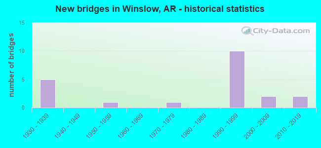
- New bridges - historical statistics
- 51930-1939
- 11950-1959
- 11970-1979
- 101990-1999
- 22000-2009
- 22010-2019


- Bridge Condition - Deck
- 17.6%Very good
- 52.9%Good
- 11.8%Satisfactory
- 17.6%Fair

- Bridge Condition - Superstructure
- 11.8%Very good
- 47.1%Good
- 29.4%Satisfactory
- 11.8%Fair

- Bridge Condition - Substructure
- 17.6%Very good
- 47.1%Good
- 23.5%Satisfactory
- 5.9%Fair
- 5.9%Poor

- Bridge Condition - Channel
- 20.0%Very good
- 50.0%Good
- 15.0%Satisfactory
- 15.0%Fair

- Bridge Condition - Culverts
- 50.0%Satisfactory
- 50.0%Fair
Find on map >> Show street view
Structure Number: 2841, Location: 4.0 Mi N SH 138-Watson (Lat: 33.852933, Lng: -91.258986), Route carried "on" structure: State highway 1, Year Built: 1952, Status: Open, Structure Length: 2.32m (7.61ft), Average Daily Traffic: 460 (year 2018), Truck Traffic: 15%, Average Future Daily Traffic: 565 (year 2028), Design Load: H 15, Features Intersected: Drainage Ditch
Minimum Vertical Clearance: 30+ m (98+ ft), Kilometerpoint: 29.628, Lanes on structure: 2, Owner: State Highway Agency, Approaching Roadway Width: 7.9m (25.9ft), Material/Design: Concrete, Design/Construction: Channel Beam, Number Of Spans In Main Unit: 4, Length of Maximum Span: 5.8m (19.0ft), Curb or Sidewalk Widths: Left: 0.2m (0.7ft), Right: 0.2m (0.7ft), Curb-To-Curb Width: 7.3m (24.0ft), Out-to-Out Width: 7.6m (24.9ft)
Condition: Deck: Satisfactory, Superstructure: Satisfactory, Substructure: Satisfactory, Channel: Good, Operating Rating: 35.4 metric tons, Method Used To Determine Operating Rating: Load Factor (LF), Inventory Rating: 21.8 metric tons, Method Used To Determine Inventory Rating: Load Factor (LF), Structural Evaluation: Equal to present minimum criteria, Deck Geometry: Meets minimum limits, Waterway Adequacy: Equal to present desirable criteria, Approach Roadway Alignment: Equal to present desirable criteria, Length Of Structure Improvement: 2.32m (7.61ft), Designated Inspection Frequency: Every 24 months, Critical Feature Inspection Frequency: Every 24 months, Inspection Date: January 2021, Total Project Cost: $83,000, Deck Structure Type: Concrete Precast Panels, Wearing Surface/Protective System: Wearing Surface: Bituminous
Find on map >> Show street view
Structure Number: 6444, Location: 1.2 MI E OF US 71 JCT (Lat: 35.846589, Lng: -94.083939), Route carried "on" structure: State highway 74, Year Built: 1993, Status: Open, Structure Length: 5.43m (17.81ft), Average Daily Traffic: 590 (year 2018), Truck Traffic: 1%, Average Future Daily Traffic: 605 (year 2028), Design Load: HS 20, Features Intersected: Hutchins Creek - Wash.
Minimum Vertical Clearance: 30+ m (98+ ft), Kilometerpoint: 1.915, Lanes on structure: 2, Owner: State Highway Agency, Approaching Roadway Width: 8.5m (27.9ft), Skew: 6 degrees, Material/Design: Steel, Design/Construction: Stringer/Multi-beam, Number Of Spans In Main Unit: 3, Length of Maximum Span: 17.7m (58.1ft), Curb-To-Curb Width: 8.5m (27.9ft), Out-to-Out Width: 9.4m (30.8ft)
Condition: Deck: Fair, Superstructure: Fair, Substructure: Fair, Channel: Fair, Operating Rating: 54.4 metric tons, Method Used To Determine Operating Rating: Load Factor (LF), Inventory Rating: 32.7 metric tons, Method Used To Determine Inventory Rating: Load Factor (LF), Structural Evaluation: Somewhat better than minimum adequacy, Deck Geometry: Somewhat better than minimum adequacy, Waterway Adequacy: Equal to present desirable criteria, Approach Roadway Alignment: Equal to present desirable criteria, Designated Inspection Frequency: Every 24 months, Critical Feature Inspection Frequency: Every 24 months, Inspection Date: Febuary 2022, Deck Structure Type: Concrete Cast-file-Place
Find on map >> Show street view
Structure Number: 6482, Location: 6.4 MI W OF US 71-16 (Lat: 35.819400, Lng: -94.192000), Route carried "on" structure: State highway 74, Year Built: 1996, Status: Open, Structure Length: 11.61m (38.09ft), Average Daily Traffic: 620 (year 2018), Truck Traffic: 1%, Average Future Daily Traffic: 689 (year 2028), Design Load: HS 20+Mod, Features Intersected: I 49 MN LANES
Minimum Vertical Clearance: 30+ m (98+ ft), Kilometerpoint: 11.249, Lanes on structure: 2, Lanes under structure: 4, Owner: State Highway Agency, Approaching Roadway Width: 9.8m (32.2ft), Material/Design: Steel continuous, Design/Construction: Stringer/Multi-beam, Number Of Spans In Main Unit: 3, Length of Maximum Span: 47.9m (157.2ft), Curb-To-Curb Width: 9.8m (32.2ft), Out-to-Out Width: 10.6m (34.8ft)
Condition: Deck: Good, Superstructure: Good, Substructure: Satisfactory, Operating Rating: 54.4 metric tons, Method Used To Determine Operating Rating: Load Factor (LF), Inventory Rating: 32.7 metric tons, Method Used To Determine Inventory Rating: Load Factor (LF), Structural Evaluation: Equal to present minimum criteria, Deck Geometry: Equal to present minimum criteria, Underclear: Equal to present minimum criteria, Approach Roadway Alignment: Equal to present desirable criteria, Designated Inspection Frequency: Every 24 months, Critical Feature Inspection Frequency: Every 24 months, Inspection Date: December 2020, Deck Structure Type: Concrete Cast-file-Place, Wearing Surface/Protective System: Wearing Surface: Monolithic Concrete, Deck Protection: Epoxy Coated Reinforcing
Find on map >> Show street view
Structure Number: 7057, Location: 4.36 Mi N Crawford Co Lin (Lat: 35.819089, Lng: -94.126097), Route carried "on" structure: US 71, Year Built: 2010, Status: Open, Structure Length: 6.10m (20.01ft), Average Daily Traffic: 1,800 (year 2018), Truck Traffic: 5%, Average Future Daily Traffic: 3,900 (year 2028), Design Load: HS 20, Features Intersected: West Fork of White River
Minimum Vertical Clearance: 30+ m (98+ ft), Kilometerpoint: 7.017, Lanes on structure: 2, Owner: State Highway Agency, Approaching Roadway Width: 12.2m (40.0ft), Skew: 4 degrees, Material/Design: Steel continuous, Design/Construction: Stringer/Multi-beam, Number Of Spans In Main Unit: 4, Length of Maximum Span: 16.8m (55.1ft), Curb-To-Curb Width: 12.2m (40.0ft), Out-to-Out Width: 13.2m (43.3ft)
Condition: Deck: Very good, Superstructure: Very good, Substructure: Very good, Channel: Good, Operating Rating: 54.4 metric tons, Method Used To Determine Operating Rating: Load Factor (LF), Inventory Rating: 32.7 metric tons, Method Used To Determine Inventory Rating: Load Factor (LF), Structural Evaluation: Equal to present desirable criteria, Deck Geometry: Better than present minimum criteria, Waterway Adequacy: Equal to present desirable criteria, Approach Roadway Alignment: Equal to present desirable criteria, Designated Inspection Frequency: Every 24 months, Critical Feature Inspection Frequency: Every 24 months, Inspection Date: July 2020, Deck Structure Type: Concrete Cast-file-Place, Wearing Surface/Protective System: Wearing Surface: Monolithic Concrete, Deck Protection: Epoxy Coated Reinforcing
Find on map >> Show street view
Structure Number: 7058, Location: 6.83 Mi N Crawford Co Lin (Lat: 35.849289, Lng: -94.104019), Route carried "on" structure: US 71, Year Built: 2010, Status: Open, Structure Length: 5.03m (16.50ft), Average Daily Traffic: 1,800 (year 2018), Truck Traffic: 5%, Average Future Daily Traffic: 3,900 (year 2028), Design Load: HS 20, Features Intersected: Hutchins Creek
Minimum Vertical Clearance: 30+ m (98+ ft), Kilometerpoint: 10.992, Lanes on structure: 2, Base Highway Network: Yes, Owner: State Highway Agency, Approaching Roadway Width: 12.2m (40.0ft), Material/Design: Steel continuous, Design/Construction: Stringer/Multi-beam, Number Of Spans In Main Unit: 3, Length of Maximum Span: 19.8m (65.0ft), Curb-To-Curb Width: 12.2m (40.0ft), Out-to-Out Width: 13.2m (43.3ft)
Condition: Deck: Very good, Superstructure: Very good, Substructure: Very good, Channel: Good, Operating Rating: 54.4 metric tons, Method Used To Determine Operating Rating: Load Factor (LF), Inventory Rating: 32.7 metric tons, Method Used To Determine Inventory Rating: Load Factor (LF), Structural Evaluation: Equal to present desirable criteria, Deck Geometry: Better than present minimum criteria, Waterway Adequacy: Equal to present desirable criteria, Approach Roadway Alignment: Equal to present desirable criteria, Designated Inspection Frequency: Every 24 months, Critical Feature Inspection Frequency: Every 24 months, Inspection Date: May 2020, Deck Structure Type: Concrete Cast-file-Place, Wearing Surface/Protective System: Wearing Surface: Monolithic Concrete, Deck Protection: Epoxy Coated Reinforcing
Find on map >> Show street view
Structure Number: 7059, Location: 0.4 Mi NW of Brentwood (Lat: 35.860339, Lng: -94.106917), Route carried "on" structure: US 71, Year Built: 2009, Status: Open, Structure Length: 3.66m (12.01ft), Average Daily Traffic: 2,800 (year 2018), Truck Traffic: 5%, Average Future Daily Traffic: 2,100 (year 2038), Design Load: HS 20, Features Intersected: London Creek
Minimum Vertical Clearance: 30+ m (98+ ft), Kilometerpoint: 12.439, Lanes on structure: 2, Base Highway Network: Yes, Owner: State Highway Agency, Approaching Roadway Width: 12.2m (40.0ft), Skew: 2 degrees, Material/Design: Steel continuous, Design/Construction: Stringer/Multi-beam, Number Of Spans In Main Unit: 3, Length of Maximum Span: 14.0m (45.9ft), Curb-To-Curb Width: 12.2m (40.0ft), Out-to-Out Width: 13.2m (43.3ft)
Condition: Deck: Very good, Superstructure: Good, Substructure: Very good, Channel: Very good, Operating Rating: 54.4 metric tons, Method Used To Determine Operating Rating: Load Factor (LF), Inventory Rating: 32.7 metric tons, Method Used To Determine Inventory Rating: Load Factor (LF), Structural Evaluation: Better than present minimum criteria, Deck Geometry: Equal to present minimum criteria, Waterway Adequacy: Equal to present desirable criteria, Approach Roadway Alignment: Equal to present desirable criteria, Designated Inspection Frequency: Every 24 months, Critical Feature Inspection Frequency: Every 24 months, Inspection Date: August 2021, Deck Structure Type: Concrete Cast-file-Place, Wearing Surface/Protective System: Wearing Surface: Monolithic Concrete, Deck Protection: Epoxy Coated Reinforcing
Find on map >> Show street view
Structure Number: 12191, Location: 2.19 M E US HWY 71 (Lat: 35.735736, Lng: -94.103042), Route carried "on" structure: County highway 36, Year Built: 1936, Status: Open, Structure Length: 2.38m (7.81ft), Average Daily Traffic: 415 (year 2018), Truck Traffic: 1%, Average Future Daily Traffic: 52 (year 2007), Design Load: H 15, Features Intersected: Jones Fork Ck-Crawford, Facility Carried by Structure: Winfrey Valley Cut
Minimum Vertical Clearance: 30+ m (98+ ft), Kilometerpoint: 3.121, Lanes on structure: 1, Owner: County Highway Agency, Approaching Roadway Width: 4.6m (15.1ft), Material/Design: Concrete, Design/Construction: Slab, Number Of Spans In Main Unit: 3, Length of Maximum Span: 7.9m (25.9ft), Curb or Sidewalk Widths: Left: 0.2m (0.7ft), Right: 0.2m (0.7ft), Curb-To-Curb Width: 3.3m (10.8ft), Out-to-Out Width: 3.7m (12.1ft)
Condition: Deck: Fair, Superstructure: Fair, Substructure: Poor, Channel: Fair, Operating Rating: 39.9 metric tons, Method Used To Determine Operating Rating: Load Factor (LF), Inventory Rating: 24.5 metric tons, Method Used To Determine Inventory Rating: Load Factor (LF), Structural Evaluation: Meets minimum limits, Deck Geometry: High priority of replacement, Waterway Adequacy: Somewhat better than minimum adequacy, Approach Roadway Alignment: Equal to present minimum criteria, Length Of Structure Improvement: 3.17m (10.40ft), Designated Inspection Frequency: Every 24 months, Critical Feature Inspection Frequency: Every 24 months, Other Special Inspection Frequency: Every 24 months, Inspection Date: November 2020, Other Special Inspection Date: November 2021, Roadway Improvement Cost: $109,000, Total Project Cost: $284,000, Deck Structure Type: Concrete Cast-file-Place, Wearing Surface/Protective System: Wearing Surface: Monolithic Concrete
Find on map >> Show street view
Structure Number: 17324, Location: 0.25 MI W OF US 71 (Lat: 35.859417, Lng: -94.110028), Route carried "on" structure: County highway 39, Year Built: 1974, Status: Posted for load, Structure Length: 2.65m (8.69ft), Average Daily Traffic: 270 (year 2018), Truck Traffic: 1%, Average Future Daily Traffic: 212 (year 2007), Design Load: H 15, Features Intersected: White River - Wash. Co., Facility Carried by Structure: Brentwood Mountain
Minimum Vertical Clearance: 30+ m (98+ ft), Kilometerpoint: 0.322, Lanes on structure: 2, Owner: County Highway Agency, Approaching Roadway Width: 7.3m (24.0ft), Material/Design: Steel continuous, Design/Construction: Stringer/Multi-beam, Number Of Spans In Main Unit: 2, Length of Maximum Span: 13.4m (44.0ft), Curb-To-Curb Width: 7.4m (24.3ft), Out-to-Out Width: 7.6m (24.9ft)
Condition: Deck: Fair, Superstructure: Satisfactory, Substructure: Good, Channel: Good, Operating Rating: 15.4 metric tons, Method Used To Determine Operating Rating: Load Factor (LF), Inventory Rating: 9.1 metric tons, Method Used To Determine Inventory Rating: Load Factor (LF), Structural Evaluation: High priority of corrective action, Deck Geometry: Somewhat better than minimum adequacy, Waterway Adequacy: Equal to present desirable criteria, Approach Roadway Alignment: Equal to present minimum criteria, Bridge Posting: Required (Relationship of Operating Rating to Maximum Legal Load: > 39.9% below), Length Of Structure Improvement: 2.65m (8.69ft), Designated Inspection Frequency: Every 24 months, Inspection Date: May 2021, Total Project Cost: $96,000, Deck Structure Type: Corrugated Steel, Wearing Surface/Protective System: Wearing Surface: Bituminous
Find on map >> Show street view
Structure Number: 2214, Location: 5.8 MI E OF US 71-16 (Lat: 35.798747, Lng: -94.061469), Route carried "on" structure: County highway 126, Year Built: 1999, Status: Open, Structure Length: 0.70m (2.30ft), Average Daily Traffic: 124 (year 2018), Truck Traffic: 40%, Average Future Daily Traffic: 28 (year 2007), Features Intersected: Jones Branch - Wash. Co., Facility Carried by Structure: Miller's Chapel Rd
Minimum Vertical Clearance: 30+ m (98+ ft), Kilometerpoint: 9.333, Lanes on structure: 1, Owner: County Highway Agency, Approaching Roadway Width: 4.3m (14.1ft), Material/Design: Steel, Design/Construction: Stringer/Multi-beam, Number Of Spans In Main Unit: 1, Length of Maximum Span: 6.4m (21.0ft), Curb-To-Curb Width: 5.0m (16.4ft), Out-to-Out Width: 5.2m (17.1ft)
Condition: Deck: Good, Superstructure: Satisfactory, Substructure: Good, Channel: Very good, Operating Rating: 49.9 metric tons, Method Used To Determine Operating Rating: Load Factor (LF), Inventory Rating: 29.9 metric tons, Method Used To Determine Inventory Rating: Load Factor (LF), Structural Evaluation: Equal to present minimum criteria, Deck Geometry: High priority of replacement, Waterway Adequacy: Equal to present desirable criteria, Approach Roadway Alignment: Equal to present minimum criteria, Designated Inspection Frequency: Every 24 months, Critical Feature Inspection Frequency: Every 24 months, Inspection Date: March 2021, Deck Structure Type: Open Grating, Wearing Surface/Protective System: Wearing Surface: Other
Find on map >> Show street view
Structure Number: 22141, Location: 6.0 MI E OF US 71-16 (Lat: 35.795944, Lng: -94.061108), Route carried "on" structure: County highway 126, Year Built: 1999, Status: Open, Structure Length: 1.83m (6.00ft), Average Daily Traffic: 124 (year 2018), Truck Traffic: 30%, Average Future Daily Traffic: 28 (year 2007), Features Intersected: Jones Creek - Wash. Co., Facility Carried by Structure: Miller's Chapel Rd
Minimum Vertical Clearance: 30+ m (98+ ft), Kilometerpoint: 9.654, Lanes on structure: 1, Owner: County Highway Agency, Approaching Roadway Width: 4.3m (14.1ft), Material/Design: Concrete, Design/Construction: Channel Beam, Number Of Spans In Main Unit: 2, Length of Maximum Span: 9.1m (29.9ft), Curb-To-Curb Width: 4.3m (14.1ft), Out-to-Out Width: 4.4m (14.4ft)
Condition: Deck: Good, Superstructure: Satisfactory, Substructure: Satisfactory, Channel: Good, Operating Rating: 49.9 metric tons, Method Used To Determine Operating Rating: Load Factor (LF), Inventory Rating: 29.9 metric tons, Method Used To Determine Inventory Rating: Load Factor (LF), Structural Evaluation: Equal to present minimum criteria, Deck Geometry: High priority of replacement, Waterway Adequacy: Equal to present desirable criteria, Approach Roadway Alignment: Equal to present desirable criteria, Designated Inspection Frequency: Every 24 months, Critical Feature Inspection Frequency: Every 24 months, Inspection Date: March 2021, Deck Structure Type: Concrete Precast Panels, Wearing Surface/Protective System: Wearing Surface: Monolithic Concrete
Find on map >> Show street view
Structure Number: 23364, Location: 0.10 Mi E Jct Hwy 71 (Lat: 35.811942, Lng: -94.128608), Route carried "on" structure: County highway 38, Year Built: 2009, Status: Open, Structure Length: 2.50m (8.20ft), Average Daily Traffic: 64 (year 2018), Truck Traffic: 1%, Average Future Daily Traffic: 494 (year 2007), Features Intersected: West Fork White River, Facility Carried by Structure: Sunset Road-Wash
Minimum Vertical Clearance: 30+ m (98+ ft), Kilometerpoint: 0.177, Lanes on structure: 2, Owner: County Highway Agency, Approaching Roadway Width: 6.1m (20.0ft), Material/Design: Concrete, Design/Construction: Channel Beam, Number Of Spans In Main Unit: 3, Length of Maximum Span: 7.9m (25.9ft), Curb-To-Curb Width: 7.8m (25.6ft), Out-to-Out Width: 8.7m (28.5ft)
Condition: Deck: Satisfactory, Superstructure: Satisfactory, Substructure: Satisfactory, Channel: Good, Operating Rating: 53.5 metric tons, Method Used To Determine Operating Rating: Load Factor (LF), Inventory Rating: 31.8 metric tons, Method Used To Determine Inventory Rating: Load Factor (LF), Structural Evaluation: Equal to present minimum criteria, Deck Geometry: Equal to present minimum criteria, Waterway Adequacy: Better than present minimum criteria, Approach Roadway Alignment: Somewhat better than minimum adequacy, Designated Inspection Frequency: Every 24 months, Critical Feature Inspection Frequency: Every 24 months, Inspection Date: May 2020, Deck Structure Type: Concrete Precast Panels, Wearing Surface/Protective System: Wearing Surface: Monolithic Concrete
Find on map >> Show street view
Structure Number: A6479, Location: .5 MI N OF HOPPER TUNNEL (Lat: 35.777758, Lng: -94.186400), Route carried "on" structure: Interstate 49, Year Built: 1997, Status: Open, Structure Length: 46.09m (151.21ft), Average Daily Traffic: 10,500 (year 2018), Truck Traffic: 1%, Average Future Daily Traffic: 11,955 (year 2028), Design Load: HS 20+Mod, Features Intersected: BLACKBURN CREEK
Minimum Vertical Clearance: 30.17m (98.98ft), Kilometerpoint: 67.609, Lanes on structure: 2, Base Highway Network: Yes, Owner: State Highway Agency, Approaching Roadway Width: 12.8m (42.0ft), Skew: 30 degrees, Material/Design: Steel continuous, Design/Construction: Stringer/Multi-beam, Number Of Spans In Main Unit: 10, Length of Maximum Span: 54.9m (180.1ft), Curb-To-Curb Width: 12.6m (41.3ft), Out-to-Out Width: 13.5m (44.3ft)
Condition: Deck: Good, Superstructure: Good, Substructure: Good, Channel: Good, Operating Rating: 54.4 metric tons, Method Used To Determine Operating Rating: Load Factor (LF), Inventory Rating: 32.7 metric tons, Method Used To Determine Inventory Rating: Load Factor (LF), Structural Evaluation: Better than present minimum criteria, Deck Geometry: Better than present minimum criteria, Waterway Adequacy: Superior to present desirable criteria, Approach Roadway Alignment: Equal to present desirable criteria, Designated Inspection Frequency: Every 24 months, Critical Feature Inspection Frequency: Every 24 months, Inspection Date: April 2020, Deck Structure Type: Concrete Cast-file-Place, Wearing Surface/Protective System: Wearing Surface: Monolithic Concrete, Deck Protection: Epoxy Coated Reinforcing
Find on map >> Show street view
Structure Number: A648, Location: 1.6 MI N OF HOPPER TUNNEL (Lat: 35.793100, Lng: -94.190081), Route carried "on" structure: Interstate 49, Year Built: 1997, Status: Open, Structure Length: 31.46m (103.22ft), Average Daily Traffic: 10,500 (year 2018), Truck Traffic: 1%, Average Future Daily Traffic: 11,955 (year 2028), Design Load: HS 20+Mod, Features Intersected: DEADMAN HOLLOW ACCESS RD
Minimum Vertical Clearance: 30+ m (98+ ft), Kilometerpoint: 69.363, Lanes on structure: 2, Lanes under structure: 2, Base Highway Network: Yes, Owner: State Highway Agency, Approaching Roadway Width: 12.8m (42.0ft), Material/Design: Steel continuous, Design/Construction: Stringer/Multi-beam, Number Of Spans In Main Unit: 5, Number Of Approach Spans: 2, Length of Maximum Span: 57.9m (190.0ft), Curb-To-Curb Width: 12.6m (41.3ft), Out-to-Out Width: 13.5m (44.3ft)
Condition: Deck: Good, Superstructure: Good, Substructure: Good, Channel: Good, Operating Rating: 54.4 metric tons, Method Used To Determine Operating Rating: Load Factor (LF), Inventory Rating: 32.7 metric tons, Method Used To Determine Inventory Rating: Load Factor (LF), Structural Evaluation: Better than present minimum criteria, Deck Geometry: Better than present minimum criteria, Underclear: Meets minimum limits, Waterway Adequacy: Superior to present desirable criteria, Approach Roadway Alignment: Equal to present desirable criteria, Designated Inspection Frequency: Every 24 months, Critical Feature Inspection Frequency: Every 24 months, Inspection Date: June 2020, Deck Structure Type: Concrete Cast-file-Place, Wearing Surface/Protective System: Wearing Surface: Monolithic Concrete, Deck Protection: Epoxy Coated Reinforcing
Find on map >> Show street view
Structure Number: A6481, Location: 1.7 MI N of Hopper Tunnel (Lat: 35.804097, Lng: -94.188000), Route carried "on" structure: Interstate 49, Year Built: 1998, Status: Open, Structure Length: 41.36m (135.70ft), Average Daily Traffic: 10,500 (year 2018), Truck Traffic: 1%, Average Future Daily Traffic: 11,955 (year 2028), Design Load: HS 20+Mod, Features Intersected: HESS CREEK
Minimum Vertical Clearance: 30+ m (98+ ft), Kilometerpoint: 70.602, Lanes on structure: 2, Base Highway Network: Yes, Owner: State Highway Agency, Approaching Roadway Width: 12.8m (42.0ft), Skew: 30 degrees, Material/Design: Steel continuous, Design/Construction: Stringer/Multi-beam, Number Of Spans In Main Unit: 5, Number Of Approach Spans: 2, Length of Maximum Span: 76.2m (250.0ft), Curb-To-Curb Width: 12.6m (41.3ft), Out-to-Out Width: 13.5m (44.3ft)
Condition: Deck: Good, Superstructure: Good, Substructure: Good, Channel: Very good, Operating Rating: 54.4 metric tons, Method Used To Determine Operating Rating: Load Factor (LF), Inventory Rating: 32.7 metric tons, Method Used To Determine Inventory Rating: Load Factor (LF), Structural Evaluation: Better than present minimum criteria, Deck Geometry: Better than present minimum criteria, Waterway Adequacy: Superior to present desirable criteria, Approach Roadway Alignment: Equal to present desirable criteria, Designated Inspection Frequency: Every 24 months, Critical Feature Inspection Frequency: Every 24 months, Inspection Date: April 2020, Deck Structure Type: Concrete Cast-file-Place, Wearing Surface/Protective System: Wearing Surface: Monolithic Concrete, Deck Protection: Epoxy Coated Reinforcing
Find on map >> Show street view
Structure Number: B6479, Location: .5 MI N OF HOPPER TUNNEL (Lat: 35.777747, Lng: -94.186269), Route carried "on" structure: Interstate 49, Year Built: 1997, Status: Open, Structure Length: 46.09m (151.21ft), Average Daily Traffic: 10,500 (year 2018), Truck Traffic: 26%, Average Future Daily Traffic: 11,955 (year 2028), Design Load: HS 20+Mod, Features Intersected: BLACKBURN CREEK
Minimum Vertical Clearance: 30+ m (98+ ft), Kilometerpoint: 67.609, Lanes on structure: 2, Base Highway Network: Yes, Owner: State Highway Agency, Approaching Roadway Width: 12.8m (42.0ft), Skew: 30 degrees, Material/Design: Steel continuous, Design/Construction: Stringer/Multi-beam, Number Of Spans In Main Unit: 10, Length of Maximum Span: 54.9m (180.1ft), Curb-To-Curb Width: 12.6m (41.3ft), Out-to-Out Width: 13.5m (44.3ft)
Condition: Deck: Good, Superstructure: Good, Substructure: Good, Channel: Good, Operating Rating: 54.4 metric tons, Method Used To Determine Operating Rating: Load Factor (LF), Inventory Rating: 32.7 metric tons, Method Used To Determine Inventory Rating: Load Factor (LF), Structural Evaluation: Better than present minimum criteria, Deck Geometry: Better than present minimum criteria, Waterway Adequacy: Superior to present desirable criteria, Approach Roadway Alignment: Equal to present desirable criteria, Designated Inspection Frequency: Every 24 months, Critical Feature Inspection Frequency: Every 24 months, Inspection Date: April 2020, Deck Structure Type: Concrete Cast-file-Place, Wearing Surface/Protective System: Wearing Surface: Monolithic Concrete, Deck Protection: Epoxy Coated Reinforcing
Find on map >> Show street view
Structure Number: B648, Location: 1.6 MI N OF HOPPER TUNNEL (Lat: 35.793081, Lng: -94.189950), Route carried "on" structure: Interstate 49, Year Built: 1997, Status: Open, Structure Length: 31.46m (103.22ft), Average Daily Traffic: 10,500 (year 2018), Truck Traffic: 26%, Average Future Daily Traffic: 11,955 (year 2028), Design Load: HS 20+Mod, Features Intersected: DEADMAN HOLLOW ACCESS RD
Minimum Vertical Clearance: 30+ m (98+ ft), Kilometerpoint: 69.363, Lanes on structure: 2, Lanes under structure: 2, Base Highway Network: Yes, Owner: State Highway Agency, Approaching Roadway Width: 12.8m (42.0ft), Material/Design: Steel continuous, Design/Construction: Stringer/Multi-beam, Number Of Spans In Main Unit: 5, Number Of Approach Spans: 2, Length of Maximum Span: 57.9m (190.0ft), Curb-To-Curb Width: 12.6m (41.3ft), Out-to-Out Width: 13.5m (44.3ft)
Condition: Deck: Good, Superstructure: Good, Substructure: Good, Channel: Good, Operating Rating: 54.4 metric tons, Method Used To Determine Operating Rating: Load Factor (LF), Inventory Rating: 32.7 metric tons, Method Used To Determine Inventory Rating: Load Factor (LF), Structural Evaluation: Better than present minimum criteria, Deck Geometry: Better than present minimum criteria, Underclear: Meets minimum limits, Waterway Adequacy: Superior to present desirable criteria, Approach Roadway Alignment: Equal to present desirable criteria, Designated Inspection Frequency: Every 24 months, Critical Feature Inspection Frequency: Every 24 months, Inspection Date: June 2020, Deck Structure Type: Concrete Cast-file-Place, Wearing Surface/Protective System: Wearing Surface: Monolithic Concrete, Deck Protection: Epoxy Coated Reinforcing
Find on map >> Show street view
Structure Number: B6481, Location: 1.7 MI.N of Hopper Tunnel (Lat: 35.804089, Lng: -94.187858), Route carried "on" structure: Interstate 49, Year Built: 1998, Status: Open, Structure Length: 41.36m (135.70ft), Average Daily Traffic: 10,500 (year 2018), Truck Traffic: 26%, Average Future Daily Traffic: 11,955 (year 2028), Design Load: HS 20+Mod, Features Intersected: HESS CREEK
Minimum Vertical Clearance: 30+ m (98+ ft), Kilometerpoint: 70.602, Lanes on structure: 2, Owner: State Highway Agency, Approaching Roadway Width: 12.8m (42.0ft), Skew: 30 degrees, Material/Design: Steel continuous, Design/Construction: Stringer/Multi-beam, Number Of Spans In Main Unit: 5, Number Of Approach Spans: 2, Length of Maximum Span: 76.2m (250.0ft), Curb-To-Curb Width: 12.7m (41.7ft), Out-to-Out Width: 13.5m (44.3ft)
Condition: Deck: Good, Superstructure: Good, Substructure: Good, Channel: Very good, Operating Rating: 54.4 metric tons, Method Used To Determine Operating Rating: Load Factor (LF), Inventory Rating: 32.7 metric tons, Method Used To Determine Inventory Rating: Load Factor (LF), Structural Evaluation: Better than present minimum criteria, Deck Geometry: Better than present minimum criteria, Waterway Adequacy: Superior to present desirable criteria, Approach Roadway Alignment: Equal to present desirable criteria, Designated Inspection Frequency: Every 24 months, Critical Feature Inspection Frequency: Every 24 months, Inspection Date: April 2020, Deck Structure Type: Concrete Cast-file-Place, Wearing Surface/Protective System: Wearing Surface: Monolithic Concrete, Deck Protection: Epoxy Coated Reinforcing
Find on map >> Show street view
Structure Number: M1379, Location: 5.0 MI NE OF SH 74 (Lat: 35.865761, Lng: -94.115811), Route carried "on" structure: US 71, Year Built: 1930, Year Reconstructed: 1964, Status: Open, Structure Length: 0.73m (2.40ft), Average Daily Traffic: 2,800 (year 2018), Truck Traffic: 5%, Average Future Daily Traffic: 3,938 (year 2028), Features Intersected: Ditch - Washington Co.
Minimum Vertical Clearance: 30+ m (98+ ft), Kilometerpoint: 13.451, Lanes on structure: 2, Base Highway Network: Yes, Owner: State Highway Agency, Approaching Roadway Width: 12.2m (40.0ft), Skew: 3 degrees, Material/Design: Concrete, Design/Construction: Culvert, Number Of Spans In Main Unit: 2, Length of Maximum Span: 3.7m (12.1ft)
Condition: Channel: Fair, Culverts: Fair, Operating Rating: 29.9 metric tons, Method Used To Determine Operating Rating: Load Factor (LF), Inventory Rating: 18.1 metric tons, Method Used To Determine Inventory Rating: Load Factor (LF), Structural Evaluation: Somewhat better than minimum adequacy, Waterway Adequacy: Equal to present minimum criteria, Approach Roadway Alignment: Equal to present desirable criteria, Designated Inspection Frequency: Every 24 months, Critical Feature Inspection Frequency: Every 24 months, Inspection Date: August 2021
Find on map >> Show street view
Structure Number: M138, Location: 5.50 MI NE OF SH 74 (Lat: 35.870189, Lng: -94.122039), Route carried "on" structure: US 71, Year Built: 1930, Status: Open, Structure Length: 0.98m (3.22ft), Average Daily Traffic: 2,800 (year 2018), Truck Traffic: 5%, Average Future Daily Traffic: 3,938 (year 2028), Features Intersected: Ditch - Washington Co.
Minimum Vertical Clearance: 30+ m (98+ ft), Kilometerpoint: 14.207, Lanes on structure: 2, Base Highway Network: Yes, Owner: State Highway Agency, Approaching Roadway Width: 12.2m (40.0ft), Material/Design: Concrete, Design/Construction: Culvert, Number Of Spans In Main Unit: 3, Length of Maximum Span: 3.4m (11.2ft)
Condition: Channel: Satisfactory, Culverts: Satisfactory, Operating Rating: 39.9 metric tons, Method Used To Determine Operating Rating: Load Factor (LF), Inventory Rating: 23.6 metric tons, Method Used To Determine Inventory Rating: Load Factor (LF), Structural Evaluation: Equal to present minimum criteria, Waterway Adequacy: Equal to present minimum criteria, Approach Roadway Alignment: Equal to present desirable criteria, Designated Inspection Frequency: Every 24 months, Critical Feature Inspection Frequency: Every 24 months, Inspection Date: August 2021
Find on map >> Show street view
Structure Number: M1381, Location: 6.0 MI NE OF SH 74 (Lat: 35.871750, Lng: -94.123919), Route carried "on" structure: US 71, Year Built: 1930, Year Reconstructed: 1964, Status: Open, Structure Length: 0.98m (3.22ft), Average Daily Traffic: 2,800 (year 2018), Truck Traffic: 5%, Average Future Daily Traffic: 3,938 (year 2028), Features Intersected: Ditch - Washington Co.
Minimum Vertical Clearance: 30+ m (98+ ft), Kilometerpoint: 14.449, Lanes on structure: 2, Base Highway Network: Yes, Owner: State Highway Agency, Approaching Roadway Width: 12.2m (40.0ft), Material/Design: Concrete, Design/Construction: Culvert, Number Of Spans In Main Unit: 3, Length of Maximum Span: 3.4m (11.2ft)
Condition: Channel: Satisfactory, Culverts: Fair, Operating Rating: 35.4 metric tons, Method Used To Determine Operating Rating: Load Factor (LF), Inventory Rating: 21.8 metric tons, Method Used To Determine Inventory Rating: Load Factor (LF), Structural Evaluation: Somewhat better than minimum adequacy, Waterway Adequacy: Equal to present minimum criteria, Approach Roadway Alignment: Equal to present desirable criteria, Designated Inspection Frequency: Every 24 months, Critical Feature Inspection Frequency: Every 24 months, Inspection Date: August 2021
Find on map >> Show street view
Structure Number: X1012, Location: JCT US 71 & CO RD 45 (Lat: 35.856981, Lng: -94.102281), Route carried "on" structure: US 71, Year Built: 1930, Year Reconstructed: 1964, Status: Open, Structure Length: 0.64m (2.10ft), Average Daily Traffic: 2,800 (year 2018), Truck Traffic: 5%, Average Future Daily Traffic: 3,938 (year 2028), Features Intersected: Ditch-Wash Co.
Minimum Vertical Clearance: 30+ m (98+ ft), Kilometerpoint: 11.874, Lanes on structure: 2, Base Highway Network: Yes, Owner: State Highway Agency, Approaching Roadway Width: 12.5m (41.0ft), Material/Design: Concrete, Design/Construction: Culvert, Number Of Spans In Main Unit: 3, Length of Maximum Span: 3.4m (11.2ft)
Condition: Channel: Satisfactory, Culverts: Satisfactory, Operating Rating: 39.0 metric tons, Method Used To Determine Operating Rating: Load Factor (LF), Inventory Rating: 23.6 metric tons, Method Used To Determine Inventory Rating: Load Factor (LF), Structural Evaluation: Equal to present minimum criteria, Waterway Adequacy: Equal to present minimum criteria, Approach Roadway Alignment: Equal to present desirable criteria, Designated Inspection Frequency: Every 24 months, Critical Feature Inspection Frequency: Every 24 months, Inspection Date: August 2021
Find on map >> Show street view
Structure Number: 6482, Location: 6.4 MI W OF US 71-16 (Lat: 35.819400, Lng: -94.192000), Route carried "under" structure: Interstate 49, Structure Length: 0. m, Average Daily Traffic: 10,000 (year 2014), Truck Traffic: 1%, Features Intersected: I 49 MN LANES, Facility Carried by Structure: SH 74-Washington
Minimum Vertical Clearance: 14.22m (46.65ft), Kilometerpoint: 72.404, Length of Maximum Span: 0.0m
Find on map >> Show street view
Structure Number: 6482, Location: 6.4 MI W OF US 71-16 (Lat: 35.819400, Lng: -94.192000), Route carried "under" structure: Interstate 49, Structure Length: 0. m, Average Daily Traffic: 10,000 (year 2014), Truck Traffic: 1%, Features Intersected: I 49 MN LANES, Facility Carried by Structure: SH 74-Washington
Minimum Vertical Clearance: 13.81m (45.31ft), Kilometerpoint: 72.404, Length of Maximum Span: 0.0m
Find on map >> Show street view
Structure Number: A648, Location: 1.6 MI N OF HOPPER TUNNEL (Lat: 35.793100, Lng: -94.190081), Route carried "under" structure: Other road , Structure Length: 0. m, Average Daily Traffic: 6 (year 1998), Truck Traffic: 1%, Features Intersected: DEADMAN HOLLOW ACCESS RD, Facility Carried by Structure: I 49 SB LNS
Minimum Vertical Clearance: 7.01m (23.00ft), Kilometerpoint: 0.402, Length of Maximum Span: 0.0m
Find on map >> Show street view
Structure Number: B648, Location: 1.6 MI N OF HOPPER TUNNEL (Lat: 35.793081, Lng: -94.189950), Route carried "under" structure: Other road , Structure Length: 0. m, Average Daily Traffic: 6 (year 1998), Truck Traffic: 1%, Features Intersected: DEADMAN HOLLOW ACCESS RD, Facility Carried by Structure: I 49 NB LNS
Minimum Vertical Clearance: 7.07m (23.20ft), Kilometerpoint: 0.418, Length of Maximum Span: 0.0m