Bridge Statistics for Winnebago, Illinois (IL)
Condition, Traffic, Stress, Structural Evaluation, Project Costs
- National Bridge Inventory (NBI) Statistics
- 11Number of bridges
- 59ft / 17.5mTotal length
- $947,000Total costs
- 52,675Total average daily traffic
- 5,575Total average daily truck traffic
- National Bridge Inventory (NBI) Registered Bridges for Winnebago
- No street view available for this location
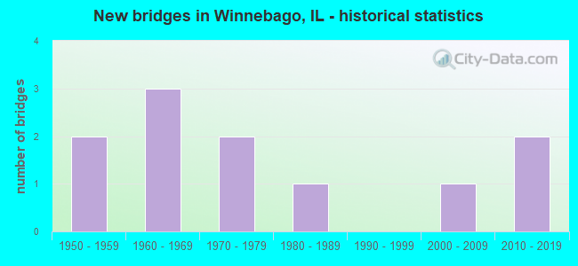
- New bridges - historical statistics
- 21950-1959
- 31960-1969
- 21970-1979
- 11980-1989
- 12000-2009
- 22010-2019


- Bridge Condition - Deck
- 50.0%Very good
- 50.0%Satisfactory

- Bridge Condition - Superstructure
- 50.0%Very good
- 50.0%Satisfactory

- Bridge Condition - Substructure
- 50.0%Very good
- 50.0%Fair

- Bridge Condition - Channel
- 25.0%Very good
- 37.5%Good
- 25.0%Satisfactory
- 12.5%Poor

- Bridge Condition - Culverts
- 14.3%Very good
- 28.6%Good
- 14.3%Satisfactory
- 28.6%Fair
- 14.3%Poor
Find on map >> Show street view
Structure Number: 1010046, Location: 3 MI W OF ROCKFORD (Lat: 42.278958, Lng: -89.194797), Route carried "on" structure: US 20, Year Built: 1961, Year Reconstructed: 2003, Status: Open, Structure Length: 8.06m (26.44ft), Average Daily Traffic: 10,700 (year 2021), Truck Traffic: 15%, Average Future Daily Traffic: 8,100 (year 2040), Design Load: HS 20+Mod, Features Intersected: US 20BR EB
Minimum Vertical Clearance: 30+ m (98+ ft), Kilometerpoint: 138.931, Lanes on structure: 2, Lanes under structure: 2, Base Highway Network: Yes, Owner: State Highway Agency, Approaching Roadway Width: 10.4m (34.1ft), Skew: 6 degrees, Material/Design: Steel continuous, Design/Construction: Stringer/Multi-beam, Number Of Spans In Main Unit: 3, Length of Maximum Span: 27.9m (91.5ft), Curb-To-Curb Width: 10.4m (34.1ft), Out-to-Out Width: 11.3m (37.1ft)
Condition: Deck: Satisfactory, Superstructure: Satisfactory, Substructure: Fair, Operating Rating: 89.1 metric tons, Method Used To Determine Operating Rating: Load Factor (LF) rating reported by rating factor (RF) method using MS18 loading, Inventory Rating: 59.9 metric tons, Method Used To Determine Inventory Rating: Load Factor (LF) rating reported by rating factor (RF) method using MS18 loading, Structural Evaluation: Somewhat better than minimum adequacy, Deck Geometry: Meets minimum limits, Underclear: High priority of corrective action, Approach Roadway Alignment: Equal to present desirable criteria, Length Of Structure Improvement: 8.11m (26.61ft), Designated Inspection Frequency: Every 24 months, Inspection Date: March 2021, Bridge Improvement Cost: $631,000, Roadway Improvement Cost: $63,000, Total Project Cost: $947,000, Deck Structure Type: Concrete Cast-file-Place, Wearing Surface/Protective System: Deck Protection: Epoxy Coated Reinforcing
Find on map >> Show street view
Structure Number: 1011006, Location: 4 MI E PECATONICA RD (Lat: 42.283611, Lng: -89.278706), Route carried "on" structure: US 20, Year Built: 2003, Status: Open, Structure Length: 0.86m (2.82ft), Average Daily Traffic: 15,900 (year 2021), Truck Traffic: 13%, Average Future Daily Traffic: 17,000 (year 2040), Design Load: HS 20, Features Intersected: COOLIDGE CREEK
Minimum Vertical Clearance: 30+ m (98+ ft), Kilometerpoint: 131.947, Lanes on structure: 4, Base Highway Network: Yes, Owner: State Highway Agency, Approaching Roadway Width: 24.7m (81.0ft), Material/Design: Concrete, Design/Construction: Culvert, Number Of Spans In Main Unit: 2, Length of Maximum Span: 4.0m (13.1ft), Curb-To-Curb Width: 24.7m (81.0ft), Out-to-Out Width: 41.8m (137.1ft)
Condition: Channel: Good, Culverts: Good, Operating Rating: 44.1 metric tons, Method Used To Determine Operating Rating: Load Factor (LF) rating reported by rating factor (RF) method using MS18 loading, Inventory Rating: 32.4 metric tons, Method Used To Determine Inventory Rating: Load Factor (LF) rating reported by rating factor (RF) method using MS18 loading, Structural Evaluation: Better than present minimum criteria, Deck Geometry: Superior to present desirable criteria, Waterway Adequacy: Better than present minimum criteria, Approach Roadway Alignment: Equal to present desirable criteria, Designated Inspection Frequency: Every 48 months, Inspection Date: August 2021
Find on map >> Show street view
Structure Number: 1013067, Location: 0.1 MI W KEITH ROAD (Lat: 42.275697, Lng: -89.271469), Route carried "on" structure: County highway , Year Built: 1970, Status: Open, Structure Length: 1.52m (4.99ft), Average Daily Traffic: 225 (year 2017), Average Future Daily Traffic: 400 (year 2040), Design Load: HS 15, Features Intersected: COOLIDGE CREEK, Facility Carried by Structure: COMLY ROAD
Minimum Vertical Clearance: 30+ m (98+ ft), Kilometerpoint: 10.460, Lanes on structure: 2, Owner: Town or Township Highway Agency, Approaching Roadway Width: 8.5m (27.9ft), Skew: 3 degrees, Material/Design: Concrete, Design/Construction: Culvert, Number Of Spans In Main Unit: 3, Length of Maximum Span: 4.1m (13.5ft)
Condition: Channel: Poor, Culverts: Fair, Operating Rating: 79.4 metric tons, Method Used To Determine Operating Rating: Load Factor (LF) rating reported by rating factor (RF) method using MS18 loading, Inventory Rating: 47.6 metric tons, Method Used To Determine Inventory Rating: Load Factor (LF) rating reported by rating factor (RF) method using MS18 loading, Structural Evaluation: Somewhat better than minimum adequacy, Waterway Adequacy: Better than present minimum criteria, Approach Roadway Alignment: Equal to present desirable criteria, Designated Inspection Frequency: Every 24 months, Inspection Date: June 2021
Find on map >> Show street view
Structure Number: 1013102, Location: 4 MI S OF WINNEBAGO (Lat: 42.207400, Lng: -89.250750), Route carried "on" structure: County highway , Year Built: 2012, Status: Open, Structure Length: 2.23m (7.32ft), Average Daily Traffic: 2,200 (year 2017), Truck Traffic: 1%, Average Future Daily Traffic: 1,800 (year 2040), Design Load: HS 25 or greater, Features Intersected: E BR MILL CRK, Facility Carried by Structure: MONTAGUE RD
Minimum Vertical Clearance: 30+ m (98+ ft), Kilometerpoint: 1.963, Lanes on structure: 2, Owner: County Highway Agency, Approaching Roadway Width: 9.8m (32.2ft), Material/Design: Prestressed concrete, Design/Construction: Stringer/Multi-beam, Number Of Spans In Main Unit: 1, Length of Maximum Span: 21.5m (70.5ft), Curb-To-Curb Width: 9.8m (32.2ft), Out-to-Out Width: 9.8m (32.2ft)
Condition: Deck: Very good, Superstructure: Very good, Substructure: Very good, Channel: Very good, Operating Rating: 49.6 metric tons, Method Used To Determine Operating Rating: Load and Resistance Factor Rating (LRFR) rating reported by rating factor(RF) method using HL-93 loadings, Inventory Rating: 39.5 metric tons, Method Used To Determine Inventory Rating: Load and Resistance Factor Rating (LRFR) rating reported by rating factor(RF) method using HL-93 loadings, Structural Evaluation: Equal to present desirable criteria, Deck Geometry: Meets minimum limits, Waterway Adequacy: Superior to present desirable criteria, Approach Roadway Alignment: Equal to present desirable criteria, Designated Inspection Frequency: Every 48 months, Inspection Date: June 2019, Deck Structure Type: Concrete Cast-file-Place, Wearing Surface/Protective System: Deck Protection: Epoxy Coated Reinforcing
Find on map >> Show street view
Structure Number: 1015045, Location: 0.5 MI E AHRENS ROAD (Lat: 42.318519, Lng: -89.285106), Route carried "on" structure: County highway , Year Built: 1957, Status: Open, Structure Length: 1.13m (3.71ft), Average Daily Traffic: 850 (year 2017), Average Future Daily Traffic: 1,300 (year 2040), Design Load: HS 15, Features Intersected: COOLIDGE CREEK, Facility Carried by Structure: SAUNDERS ROAD
Minimum Vertical Clearance: 30+ m (98+ ft), Kilometerpoint: 3.911, Lanes on structure: 2, Owner: County Highway Agency, Approaching Roadway Width: 11.0m (36.1ft), Skew: 1 degrees, Material/Design: Concrete, Design/Construction: Culvert, Number Of Spans In Main Unit: 3, Length of Maximum Span: 3.4m (11.2ft)
Condition: Channel: Good, Culverts: Fair, Operating Rating: 40.5 metric tons, Method Used To Determine Operating Rating: Field evaluation and documented engineering judgment, Inventory Rating: 24.3 metric tons, Method Used To Determine Inventory Rating: Field evaluation and documented engineering judgment, Structural Evaluation: Somewhat better than minimum adequacy, Waterway Adequacy: Better than present minimum criteria, Approach Roadway Alignment: Equal to present desirable criteria, Designated Inspection Frequency: Every 24 months, Inspection Date: May 2020
Find on map >> Show street view
Structure Number: 1015067, Location: 1 MI E HOISINGTON RD (Lat: 42.304131, Lng: -89.281731), Route carried "on" structure: County highway , Year Built: 1970, Status: Open, Structure Length: 1.41m (4.63ft), Average Daily Traffic: 1,200 (year 2017), Average Future Daily Traffic: 3,200 (year 2040), Design Load: HS 15, Features Intersected: COOLIDGE CREEK, Facility Carried by Structure: SMITH ROAD
Minimum Vertical Clearance: 30+ m (98+ ft), Kilometerpoint: 1.561, Lanes on structure: 2, Owner: Town or Township Highway Agency, Approaching Roadway Width: 9.8m (32.2ft), Skew: 3 degrees, Material/Design: Concrete, Design/Construction: Culvert, Number Of Spans In Main Unit: 3, Length of Maximum Span: 3.0m (9.8ft)
Condition: Channel: Satisfactory, Culverts: Good, Operating Rating: 36.0 metric tons, Method Used To Determine Operating Rating: Load Factor (LF) rating reported by rating factor (RF) method using MS18 loading, Inventory Rating: 21.7 metric tons, Method Used To Determine Inventory Rating: Load Factor (LF) rating reported by rating factor (RF) method using MS18 loading, Structural Evaluation: Somewhat better than minimum adequacy, Waterway Adequacy: Better than present minimum criteria, Approach Roadway Alignment: Equal to present desirable criteria, Designated Inspection Frequency: Every 24 months, Inspection Date: March 2020
Find on map >> Show street view
Structure Number: 1015117, Location: 2 MI W MERIDIAN RD (Lat: 42.213297, Lng: -89.209714), Route carried "on" structure: County highway , Year Built: 1983, Status: Open, Structure Length: 0.78m (2.56ft), Average Daily Traffic: 3,600 (year 2017), Average Future Daily Traffic: 6,000 (year 2040), Design Load: HS 20, Features Intersected: E BR MOSQUITO CREEK, Facility Carried by Structure: MONTAGUE ROAD
Minimum Vertical Clearance: 30+ m (98+ ft), Kilometerpoint: 5.423, Lanes on structure: 2, Owner: County Highway Agency, Approaching Roadway Width: 12.2m (40.0ft), Material/Design: Concrete, Design/Construction: Culvert, Number Of Spans In Main Unit: 2, Length of Maximum Span: 3.7m (12.1ft)
Condition: Channel: Good, Culverts: Satisfactory, Operating Rating: 88.8 metric tons, Method Used To Determine Operating Rating: Load Factor (LF) rating reported by rating factor (RF) method using MS18 loading, Inventory Rating: 64.2 metric tons, Method Used To Determine Inventory Rating: Load Factor (LF) rating reported by rating factor (RF) method using MS18 loading, Structural Evaluation: Equal to present minimum criteria, Waterway Adequacy: Equal to present minimum criteria, Approach Roadway Alignment: Equal to present desirable criteria, Designated Inspection Frequency: Every 24 months, Inspection Date: April 2021
Find on map >> Show street view
Structure Number: 1015163, Location: 2 MI E OF WINNEBAGO (Lat: 42.262789, Lng: -89.192636), Route carried "on" structure: County highway , Year Built: 2018, Status: Open, Structure Length: 0.80m (2.62ft), Average Daily Traffic: 1,150 (year 2012), Truck Traffic: 1%, Average Future Daily Traffic: 2,400 (year 2040), Design Load: HS 25 or greater, Features Intersected: S BR OF KENT CRK, Facility Carried by Structure: TR-100 (Weldon Rd)
Minimum Vertical Clearance: 30+ m (98+ ft), Kilometerpoint: 3.573, Lanes on structure: 2, Owner: Town or Township Highway Agency, Approaching Roadway Width: 6.7m (22.0ft), Skew: 2 degrees, Material/Design: Concrete continuous, Design/Construction: Culvert, Number Of Spans In Main Unit: 2, Length of Maximum Span: 4.1m (13.5ft)
Condition: Channel: Very good, Culverts: Very good, Operating Rating: 86.8 metric tons, Method Used To Determine Operating Rating: Load and Resistance Factor Rating (LRFR) rating reported by rating factor(RF) method using HL-93 loadings, Inventory Rating: 67.1 metric tons, Method Used To Determine Inventory Rating: Load and Resistance Factor Rating (LRFR) rating reported by rating factor(RF) method using HL-93 loadings, Structural Evaluation: Equal to present desirable criteria, Waterway Adequacy: Superior to present desirable criteria, Approach Roadway Alignment: Superior to present desirable criteria, Designated Inspection Frequency: Every 48 months, Inspection Date: August 2020, Deck Structure Type: Concrete Cast-file-Place
Find on map >> Show street view
Structure Number: 1015166, Location: 3.5 MI E OF PECATONI (Lat: 42.318689, Lng: -89.279633), Route carried "on" structure: County highway , Year Built: 1957, Status: Open, Structure Length: 0.72m (2.36ft), Average Daily Traffic: 850 (year 2017), Average Future Daily Traffic: 915 (year 2034), Design Load: HS 15, Features Intersected: UNNAMED CREEK, Facility Carried by Structure: SAUNDERS RD
Minimum Vertical Clearance: 30+ m (98+ ft), Kilometerpoint: 4.361, Lanes on structure: 2, Owner: County Highway Agency, Approaching Roadway Width: 11.0m (36.1ft), Skew: 4 degrees, Material/Design: Concrete continuous, Design/Construction: Culvert, Number Of Spans In Main Unit: 2, Length of Maximum Span: 3.2m (10.5ft)
Condition: Channel: Satisfactory, Culverts: Poor, Operating Rating: 48.3 metric tons, Method Used To Determine Operating Rating: Load Factor (LF) rating reported by rating factor (RF) method using MS18 loading, Inventory Rating: 28.8 metric tons, Method Used To Determine Inventory Rating: Load Factor (LF) rating reported by rating factor (RF) method using MS18 loading, Structural Evaluation: Meets minimum limits, Waterway Adequacy: Better than present minimum criteria, Approach Roadway Alignment: Equal to present desirable criteria, Designated Inspection Frequency: Every 24 months, Inspection Date: January 2021
Find on map >> Show street view
Structure Number: 1010046, Location: 3 MI W OF ROCKFORD (Lat: 42.280086, Lng: -89.196250), Route carried "under" structure: Business US 20, Year Built: 1961, Structure Length: 0. m, Average Daily Traffic: 5,300 (year 2021), Truck Traffic: 5%, Features Intersected: US 20BR EB
Minimum Vertical Clearance: 4.52m (14.83ft), Kilometerpoint: 18.426, Lanes on structure: 2, Lanes under structure: 2, Material/Design: Steel continuous, Design/Construction: Stringer/Multi-beam, Length of Maximum Span: 27.9m (91.5ft)
Find on map >> Show street view
Structure Number: 101012, Location: .2 MI S RT 20 BR (Lat: 42.277831, Lng: -89.192850), Route carried "under" structure: US 20, Year Built: 1961, Structure Length: 0. m, Average Daily Traffic: 10,700 (year 2021), Truck Traffic: 15%, Features Intersected: US RT 20, Facility Carried by Structure: WELDON RD
Minimum Vertical Clearance: 4.88m (16.01ft), Kilometerpoint: 139.124, Lanes on structure: 2, Lanes under structure: 4, Material/Design: Steel continuous, Design/Construction: Stringer/Multi-beam, Length of Maximum Span: 23.0m (75.5ft)