Bridge Statistics for Winfield, West Virginia (WV)
Condition, Traffic, Stress, Structural Evaluation, Project Costs
- National Bridge Inventory (NBI) Statistics
- 12Number of bridges
- 200ft / 60.9mTotal length
- $550,000Total costs
- 62,762Total average daily traffic
- 7,629Total average daily truck traffic
- National Bridge Inventory (NBI) Registered Bridges for Winfield
- No street view available for this location
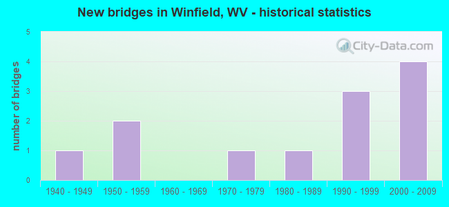
- New bridges - historical statistics
- 11940-1949
- 21950-1959
- 11970-1979
- 11980-1989
- 31990-1999
- 42000-2009
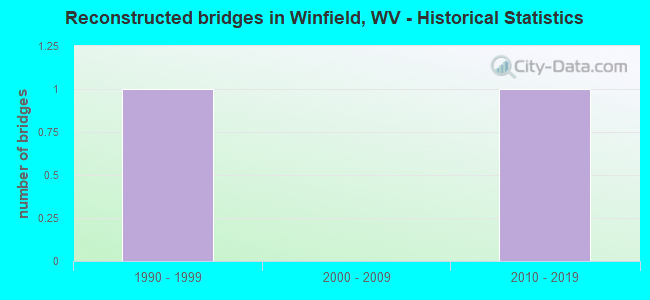
- Reconstructed bridges - Historical Statistics
- 11990-1999
- 02000-2009
- 12010-2019
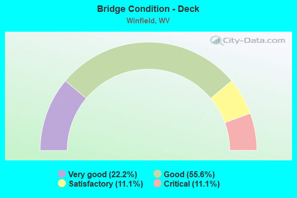
- Bridge Condition - Deck
- 22.2%Very good
- 55.6%Good
- 11.1%Satisfactory
- 11.1%Critical
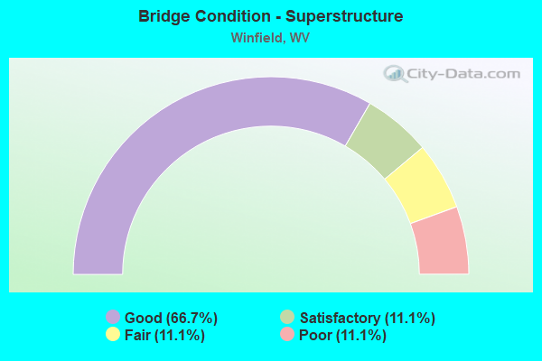
- Bridge Condition - Superstructure
- 66.7%Good
- 11.1%Satisfactory
- 11.1%Fair
- 11.1%Poor
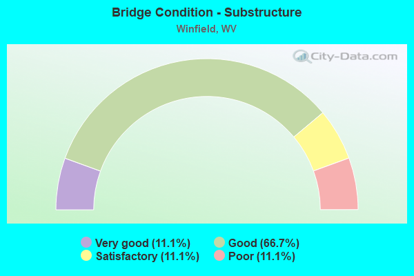
- Bridge Condition - Substructure
- 11.1%Very good
- 66.7%Good
- 11.1%Satisfactory
- 11.1%Poor
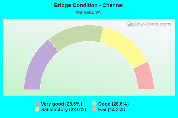
- Bridge Condition - Channel
- 28.6%Very good
- 28.6%Good
- 28.6%Satisfactory
- 14.3%Fair
Find on map >> Show street view
Structure Number: 40A026, Location: 0.21 MI S OF CR 29/4 (Lat: 38.507181, Lng: -81.895381), Route carried "on" structure: County highway 29, Year Built: 1970, Status: Posted for load, Structure Length: 0.94m (3.08ft), Average Daily Traffic: 450 (year 2018), Truck Traffic: 4%, Average Future Daily Traffic: 608 (year 2038), Features Intersected: LITTLE HURRICANE CREEK
Minimum Vertical Clearance: 30+ m (98+ ft), Kilometerpoint: 7.290, Lanes on structure: 2, Owner: State Highway Agency, Approaching Roadway Width: 4.9m (16.1ft), Material/Design: Steel, Design/Construction: Stringer/Multi-beam, Number Of Spans In Main Unit: 1, Length of Maximum Span: 8.4m (27.6ft), Curb or Sidewalk Widths: Left: 0.2m (0.7ft), Right: 0.2m (0.7ft), Curb-To-Curb Width: 6.3m (20.7ft), Out-to-Out Width: 6.7m (22.0ft)
Condition: Deck: Critical, Superstructure: Poor, Substructure: Poor, Channel: Fair, Operating Rating: 25.4 metric tons, Method Used To Determine Operating Rating: Load Factor (LF), Inventory Rating: 14.5 metric tons, Method Used To Determine Inventory Rating: Load Factor (LF), Structural Evaluation: Meets minimum limits, Deck Geometry: High priority of corrective action, Waterway Adequacy: Equal to present minimum criteria, Approach Roadway Alignment: High priority of corrective action, Bridge Posting: Required (Relationship of Operating Rating to Maximum Legal Load: > 39.9% below), Length Of Structure Improvement: 1.22m (4.00ft), Designated Inspection Frequency: Every 24 months, Other Special Inspection Frequency: Every 12 months, Inspection Date: April 2019, Other Special Inspection Date: March 2020, Bridge Improvement Cost: $500,000, Roadway Improvement Cost: $50,000, Total Project Cost: $550,000 ( Estimate for 2020), Deck Structure Type: Wood or Timber, Wearing Surface/Protective System: Wearing Surface: Bituminous
Find on map >> Show street view
Structure Number: 40A035, Location: 0.31 MI N OF WV 817 (Lat: 38.535000, Lng: -81.898300), Route carried "on" structure: State highway 3400, Year Built: 1955, Year Reconstructed: 2010, Status: Open, Structure Length: 43.69m (143.34ft), Average Daily Traffic: 7,100 (year 2020), Truck Traffic: 6%, Average Future Daily Traffic: 8,733 (year 2040), Design Load: HS 20, Features Intersected: KANAWHA RV, WV62, N&S RR, Facility Carried by Structure: WV 34
Minimum Vertical Clearance: 4.19m (13.75ft), Kilometerpoint: 34.343, Lanes on structure: 2, Lanes under structure: 2, Owner: State Highway Agency, Approaching Roadway Width: 8.5m (27.9ft), Navigation Control: Yes ( Vertical Clearance: 18.3m (60.0ft), Horizontal Clearance: 134.1m (440.0ft)), Material/Design: Steel continuous, Design/Construction: Truss - Thru, Number Of Spans In Main Unit: 1, Number Of Approach Spans: 9, Length of Maximum Span: 140.8m (461.9ft), Curb or Sidewalk Widths: Left: 1.6m (5.2ft), Right: 0.0m, Curb-To-Curb Width: 8.5m (27.9ft), Out-to-Out Width: 10.7m (35.1ft)
Condition: Deck: Good, Superstructure: Fair, Substructure: Good, Channel: Very good, Operating Rating: 52.6 metric tons, Method Used To Determine Operating Rating: Load Factor (LF), Inventory Rating: 31.7 metric tons, Method Used To Determine Inventory Rating: Load Factor (LF), Structural Evaluation: Somewhat better than minimum adequacy, Deck Geometry: High priority of corrective action, Underclear: Equal to present minimum criteria, Waterway Adequacy: Superior to present desirable criteria, Approach Roadway Alignment: Meets minimum limits, Designated Inspection Frequency: Every 24 months, Critical Feature Inspection Frequency: Every 12 months, Underwater Inspection Frequency: Every 60 months, Other Special Inspection Frequency: Every 12 months, Inspection Date: October 2021, Critical Feature Inspection Date: October 2021, Underwater Inspection Date: October 2018, Other Special Inspection Date: October 2021, Deck Structure Type: Concrete Cast-file-Place, Wearing Surface/Protective System: Wearing Surface: Monolithic Concrete, Deck Protection: Epoxy Coated Reinforcing
Find on map >> Show street view
Structure Number: 40A088, Location: 0.06 MI S OF CR 29 (Lat: 38.508161, Lng: -81.898869), Route carried "on" structure: County highway 2904, Year Built: 1980, Status: Open, Structure Length: 1.27m (4.17ft), Average Daily Traffic: 50 (year 2020), Truck Traffic: 4%, Average Future Daily Traffic: 67 (year 2040), Design Load: HS 20, Features Intersected: LITTLE HURRICANE CREEK, Facility Carried by Structure: CR 29/4
Minimum Vertical Clearance: 30+ m (98+ ft), Kilometerpoint: 2.881, Lanes on structure: 2, Owner: State Highway Agency, Approaching Roadway Width: 4.3m (14.1ft), Skew: 3 degrees, Material/Design: Prestressed concrete, Design/Construction: Box Beam or Girders - Multiple, Number Of Spans In Main Unit: 1, Length of Maximum Span: 12.2m (40.0ft), Curb or Sidewalk Widths: Left: 0.2m (0.7ft), Right: 0.2m (0.7ft), Curb-To-Curb Width: 5.9m (19.4ft), Out-to-Out Width: 6.4m (21.0ft)
Condition: Deck: Good, Superstructure: Good, Substructure: Good, Channel: Satisfactory, Operating Rating: 62.6 metric tons, Method Used To Determine Operating Rating: Load Factor (LF), Inventory Rating: 37.2 metric tons, Method Used To Determine Inventory Rating: Load Factor (LF), Structural Evaluation: Better than present minimum criteria, Deck Geometry: Meets minimum limits, Waterway Adequacy: Better than present minimum criteria, Approach Roadway Alignment: Equal to present desirable criteria, Designated Inspection Frequency: Every 24 months, Inspection Date: July 2021, Deck Structure Type: Other, Wearing Surface/Protective System: Wearing Surface: Bituminous
Find on map >> Show street view
Structure Number: 40A127, Location: 0.77 MI E OF CR 7 (Lat: 38.593419, Lng: -81.877611), Route carried "on" structure: County highway 1100, Year Built: 1999, Status: Open, Structure Length: 0.84m (2.76ft), Average Daily Traffic: 40 (year 2018), Truck Traffic: 3%, Average Future Daily Traffic: 54 (year 2038), Design Load: HS 20, Features Intersected: BUFFALO BRANCH, Facility Carried by Structure: COUNTY ROUTE 11
Minimum Vertical Clearance: 30+ m (98+ ft), Kilometerpoint: 15.659, Lanes on structure: 2, Owner: State Highway Agency, Approaching Roadway Width: 5.5m (18.0ft), Material/Design: Steel, Design/Construction: Stringer/Multi-beam, Number Of Spans In Main Unit: 1, Length of Maximum Span: 8.1m (26.6ft), Curb or Sidewalk Widths: Left: 0.1m (0.3ft), Right: 0.1m (0.3ft), Curb-To-Curb Width: 5.5m (18.0ft), Out-to-Out Width: 5.5m (18.0ft)
Condition: Deck: Good, Superstructure: Good, Substructure: Good, Channel: Very good, Operating Rating: 62.6 metric tons, Method Used To Determine Operating Rating: Load Factor (LF), Inventory Rating: 37.2 metric tons, Method Used To Determine Inventory Rating: Load Factor (LF), Structural Evaluation: Better than present minimum criteria, Deck Geometry: Meets minimum limits, Waterway Adequacy: Better than present minimum criteria, Approach Roadway Alignment: Equal to present minimum criteria, Designated Inspection Frequency: Every 24 months, Inspection Date: January 2021, Deck Structure Type: Concrete Cast-file-Place, Wearing Surface/Protective System: Wearing Surface: Monolithic Concrete, Deck Protection: Epoxy Coated Reinforcing
Find on map >> Show street view
Structure Number: 40A128, Location: 0.30 MI. S. OF US 35 (Lat: 38.520639, Lng: -81.910561), Route carried "on" structure: State highway 3400, Year Built: 1949, Year Reconstructed: 1998, Status: Open, Structure Length: 5.52m (18.11ft), Average Daily Traffic: 9,300 (year 2019), Truck Traffic: 7%, Average Future Daily Traffic: 12,555 (year 2039), Design Load: HS 25 or greater, Features Intersected: LITTLE HURRICANE CREEK, Facility Carried by Structure: WV 34
Minimum Vertical Clearance: 30+ m (98+ ft), Kilometerpoint: 31.978, Lanes on structure: 2, Owner: State Highway Agency, Approaching Roadway Width: 7.9m (25.9ft), Material/Design: Steel continuous, Design/Construction: Stringer/Multi-beam, Number Of Spans In Main Unit: 1, Number Of Approach Spans: 2, Length of Maximum Span: 19.8m (65.0ft), Curb-To-Curb Width: 9.6m (31.5ft), Out-to-Out Width: 10.7m (35.1ft)
Condition: Deck: Good, Superstructure: Good, Substructure: Good, Channel: Satisfactory, Operating Rating: 59.0 metric tons, Method Used To Determine Operating Rating: Load Factor (LF), Inventory Rating: 35.4 metric tons, Method Used To Determine Inventory Rating: Load Factor (LF), Structural Evaluation: Better than present minimum criteria, Deck Geometry: High priority of corrective action, Waterway Adequacy: Superior to present desirable criteria, Approach Roadway Alignment: Superior to present desirable criteria, Designated Inspection Frequency: Every 24 months, Inspection Date: October 2020, Deck Structure Type: Concrete Cast-file-Place, Wearing Surface/Protective System: Wearing Surface: Monolithic Concrete, Deck Protection: Epoxy Coated Reinforcing
Find on map >> Show street view
Structure Number: 40A133, Location: 1.00 MILE NORTH OF WV 34 (Lat: 38.566481, Lng: -81.883889), Route carried "on" structure: County highway 7, Year Built: 1999, Status: Open, Structure Length: 0.84m (2.76ft), Average Daily Traffic: 150 (year 2018), Truck Traffic: 3%, Average Future Daily Traffic: 203 (year 2038), Features Intersected: BUFFALO CREEK
Minimum Vertical Clearance: 30+ m (98+ ft), Kilometerpoint: 1.609, Lanes on structure: 1, Owner: State Highway Agency, Approaching Roadway Width: 3.7m (12.1ft), Material/Design: Steel, Design/Construction: Stringer/Multi-beam, Number Of Spans In Main Unit: 1, Length of Maximum Span: 8.1m (26.6ft), Curb or Sidewalk Widths: Left: 0.1m (0.3ft), Right: 0.1m (0.3ft), Curb-To-Curb Width: 4.6m (15.1ft), Out-to-Out Width: 4.6m (15.1ft)
Condition: Deck: Very good, Superstructure: Good, Substructure: Good, Channel: Good, Operating Rating: 88.9 metric tons, Method Used To Determine Operating Rating: Load Factor (LF), Inventory Rating: 61.7 metric tons, Method Used To Determine Inventory Rating: Load Factor (LF), Structural Evaluation: Better than present minimum criteria, Deck Geometry: High priority of replacement, Waterway Adequacy: Equal to present desirable criteria, Approach Roadway Alignment: Equal to present minimum criteria, Designated Inspection Frequency: Every 24 months, Inspection Date: March 2020, Deck Structure Type: Concrete Cast-file-Place, Wearing Surface/Protective System: Wearing Surface: Monolithic Concrete, Deck Protection: Epoxy Coated Reinforcing
Find on map >> Show street view
Structure Number: 40A139, Location: 0.02 MIL SO OF CR 33 (Lat: 38.449911, Lng: -81.929611), Route carried "on" structure: Other road 960, Year Built: 1991, Status: Open, Structure Length: 1.10m (3.61ft), Average Daily Traffic: 1,000 (year 2020), Truck Traffic: 4%, Average Future Daily Traffic: 1,340 (year 2040), Design Load: HS 25 or greater, Features Intersected: POPLAR FORK
Minimum Vertical Clearance: 30+ m (98+ ft), Kilometerpoint: 0.032, Lanes on structure: 1, Owner: State Highway Agency, Approaching Roadway Width: 4.6m (15.1ft), Material/Design: Prestressed concrete, Design/Construction: Box Beam or Girders - Multiple, Number Of Spans In Main Unit: 1, Length of Maximum Span: 10.5m (34.4ft), Curb-To-Curb Width: 4.4m (14.4ft), Out-to-Out Width: 4.6m (15.1ft)
Condition: Deck: Satisfactory, Superstructure: Satisfactory, Substructure: Satisfactory, Channel: Good, Operating Rating: 88.9 metric tons, Method Used To Determine Operating Rating: Load Factor (LF), Inventory Rating: 68.9 metric tons, Method Used To Determine Inventory Rating: Load Factor (LF), Structural Evaluation: Equal to present minimum criteria, Deck Geometry: High priority of replacement, Waterway Adequacy: Better than present minimum criteria, Approach Roadway Alignment: Equal to present minimum criteria, Designated Inspection Frequency: Every 24 months, Inspection Date: September 2021, Deck Structure Type: Other, Wearing Surface/Protective System: Wearing Surface: Bituminous, Deck Protection: Epoxy Coated Reinforcing
Find on map >> Show street view
Structure Number: 40A145, Location: 2.34 MILE N OF I 64 (Lat: 38.482119, Lng: -81.927619), Route carried "on" structure: US 35, Year Built: 2009, Status: Open, Structure Length: 3.37m (11.06ft), Average Daily Traffic: 11,900 (year 2020), Truck Traffic: 22%, Average Future Daily Traffic: 16,065 (year 2040), Design Load: HL 93, Features Intersected: WV 34
Minimum Vertical Clearance: 30+ m (98+ ft), Kilometerpoint: 3.862, Lanes on structure: 2, Lanes under structure: 3, Base Highway Network: Yes, Owner: State Highway Agency, Approaching Roadway Width: 11.6m (38.1ft), Skew: 1 degrees, Material/Design: Prestressed concrete, Design/Construction: Stringer/Multi-beam, Number Of Spans In Main Unit: 1, Length of Maximum Span: 32.8m (107.6ft), Curb-To-Curb Width: 12.8m (42.0ft), Out-to-Out Width: 13.6m (44.6ft)
Condition: Deck: Very good, Superstructure: Good, Substructure: Very good, Operating Rating: 69.8 metric tons, Method Used To Determine Operating Rating: Load and Resistance Factor (LRFR), Inventory Rating: 53.5 metric tons, Method Used To Determine Inventory Rating: Load and Resistance Factor (LRFR), Structural Evaluation: Better than present minimum criteria, Deck Geometry: Equal to present desirable criteria, Underclear: Better than present minimum criteria, Approach Roadway Alignment: Equal to present desirable criteria, Designated Inspection Frequency: Every 24 months, Inspection Date: December 2021, Deck Structure Type: Concrete Cast-file-Place, Wearing Surface/Protective System: Wearing Surface: Monolithic Concrete, Deck Protection: Epoxy Coated Reinforcing
Find on map >> Show street view
Structure Number: 40A154, Location: 2.34 MILE N OF I 64 (Lat: 38.481919, Lng: -81.927750), Route carried "on" structure: US 35, Year Built: 2009, Status: Open, Structure Length: 3.37m (11.06ft), Average Daily Traffic: 11,900 (year 2020), Truck Traffic: 22%, Average Future Daily Traffic: 16,065 (year 2040), Design Load: HL 93, Features Intersected: WV 34
Minimum Vertical Clearance: 30+ m (98+ ft), Kilometerpoint: 3.862, Lanes on structure: 2, Lanes under structure: 3, Base Highway Network: Yes, Owner: State Highway Agency, Approaching Roadway Width: 11.6m (38.1ft), Skew: 1 degrees, Material/Design: Prestressed concrete, Design/Construction: Stringer/Multi-beam, Number Of Spans In Main Unit: 1, Length of Maximum Span: 32.8m (107.6ft), Curb-To-Curb Width: 12.8m (42.0ft), Out-to-Out Width: 13.6m (44.6ft)
Condition: Deck: Good, Superstructure: Good, Substructure: Good, Operating Rating: 69.8 metric tons, Method Used To Determine Operating Rating: Load and Resistance Factor (LRFR), Inventory Rating: 53.5 metric tons, Method Used To Determine Inventory Rating: Load and Resistance Factor (LRFR), Structural Evaluation: Better than present minimum criteria, Deck Geometry: Equal to present desirable criteria, Underclear: Superior to present desirable criteria, Approach Roadway Alignment: Equal to present desirable criteria, Designated Inspection Frequency: Every 24 months, Inspection Date: December 2021, Deck Structure Type: Concrete Cast-file-Place, Wearing Surface/Protective System: Wearing Surface: Monolithic Concrete, Deck Protection: Epoxy Coated Reinforcing
Find on map >> Show street view
Structure Number: 40A035, Location: 0.31 MI N OF WV 817 (Lat: 38.000000, Lng: -81.000000), Route carried "under" structure: State highway 6200, Year Built: 1955, Structure Length: 0. m, Average Daily Traffic: 6,350 (year 0007), Truck Traffic: 6%, Features Intersected: KANAWHA RV, WV62, N&S RR, Facility Carried by Structure: WV 34
Minimum Vertical Clearance: 4.78m (15.68ft), Kilometerpoint: 17.429, Lanes on structure: 2, Lanes under structure: 2, Length of Maximum Span: 140.8m (461.9ft)
Find on map >> Show street view
Structure Number: 40A145, Location: 2.34 MILE N OF I 64 (Lat: 38.482119, Lng: -81.927619), Route carried "under" structure: State highway 3400, Year Built: 2009, Structure Length: 0. m, Average Daily Traffic: 7,261 (year 0015), Truck Traffic: 6%, Features Intersected: WV 34, Facility Carried by Structure: US 35 NB
Minimum Vertical Clearance: 6.88m (22.57ft), Kilometerpoint: 27.198, Lanes on structure: 2, Lanes under structure: 3, Length of Maximum Span: 32.8m (107.6ft)
Find on map >> Show street view
Structure Number: 40A154, Location: 2.34 MILE N OF I 64 (Lat: 38.176000, Lng: -81.331100), Route carried "under" structure: State highway 340, Year Built: 2009, Structure Length: 0. m, Average Daily Traffic: 7,261 (year 0015), Truck Traffic: 6%, Features Intersected: WV 34, Facility Carried by Structure: US 35 SB
Minimum Vertical Clearance: 6.88m (22.57ft), Kilometerpoint: 27.198, Lanes on structure: 2, Lanes under structure: 3, Length of Maximum Span: 32.8m (107.6ft)