Bridge Statistics for Wind Gap, Pennsylvania (PA)
Condition, Traffic, Stress, Structural Evaluation, Project Costs
- National Bridge Inventory (NBI) Statistics
- 19Number of bridges
- 66ft / 19.9mTotal length
- $888,000Total costs
- 193,510Total average daily traffic
- 25,589Total average daily truck traffic
- National Bridge Inventory (NBI) Registered Bridges for Wind Gap
- No street view available for this location
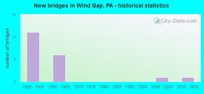
- New bridges - historical statistics
- 111950-1959
- 61960-1969
- 12000-2009
- 12010-2019

- Reconstructed bridges - Historical Statistics
- 11990-1999
- 02000-2009
- 22010-2019


- Bridge Condition - Deck
- 12.5%Very good
- 12.5%Good
- 50.0%Satisfactory
- 25.0%Fair

- Bridge Condition - Superstructure
- 25.0%Good
- 75.0%Satisfactory

- Bridge Condition - Substructure
- 37.5%Good
- 25.0%Satisfactory
- 37.5%Fair

- Bridge Condition - Channel
- 16.7%Good
- 50.0%Satisfactory
- 33.3%Poor

- Bridge Condition - Culverts
- 50.0%Very good
- 50.0%Good
Find on map >> Show street view
Structure Number: 28516, Location: KROMER RD.OVER PA.33 (Lat: 40.820097, Lng: -75.297719), Route carried "on" structure: State highway , Year Built: 1969, Year Reconstructed: 2017, Status: Open, Structure Length: 5.46m (17.91ft), Average Daily Traffic: 486 (year 2022), Truck Traffic: 6%, Average Future Daily Traffic: 1,753 (year 2036), Design Load: HL 93, Features Intersected: PA 33(LR 1098), Facility Carried by Structure: SR1042 T614 KROMER
Minimum Vertical Clearance: 30+ m (98+ ft), Kilometerpoint: 0.000, Lanes on structure: 2, Lanes under structure: 8, Owner: State Highway Agency, Approaching Roadway Width: 10.1m (33.1ft), Material/Design: Prestressed concrete, Design/Construction: Stringer/Multi-beam, Number Of Spans In Main Unit: 2, Length of Maximum Span: 26.8m (87.9ft), Curb-To-Curb Width: 9.8m (32.2ft), Out-to-Out Width: 10.8m (35.4ft)
Condition: Deck: Very good, Superstructure: Good, Substructure: Good, Operating Rating: 48.0 metric tons, Method Used To Determine Operating Rating: Assigned ratings based on Load and Resistance Factor Design (LRFD) reported by rating factor (RF) using HL93 loadings, Inventory Rating: 36.9 metric tons, Method Used To Determine Inventory Rating: Assigned ratings based on Load and Resistance Factor Design (LRFD) reported by rating factor (RF) using HL93 loadings, Structural Evaluation: Better than present minimum criteria, Deck Geometry: Equal to present minimum criteria, Underclear: Equal to present minimum criteria, Approach Roadway Alignment: Equal to present desirable criteria, Length Of Structure Improvement: 6.50m (21.33ft), Designated Inspection Frequency: Every 48 months, Inspection Date: December 2019, Deck Structure Type: Concrete Cast-file-Place, Wearing Surface/Protective System: Wearing Surface: Monolithic Concrete, Deck Protection: Epoxy Coated Reinforcing
Find on map >> Show street view
Structure Number: 28519, Location: PA 33 OVER MALE STREET (Lat: 40.838075, Lng: -75.300392), Route carried "on" structure: State highway 33, Year Built: 1958, Year Reconstructed: 2015, Status: Open, Structure Length: 1.10m (3.61ft), Average Daily Traffic: 37,369 (year 2021), Truck Traffic: 15%, Average Future Daily Traffic: 43,653 (year 2032), Design Load: HS 20, Features Intersected: MALE ST (FORMER SR 1028)
Minimum Vertical Clearance: 30+ m (98+ ft), Kilometerpoint: 23.899, Lanes on structure: 4, Lanes under structure: 2, Base Highway Network: Yes, Owner: State Highway Agency, Approaching Roadway Width: 24.4m (80.1ft), Skew: 21 degrees, Material/Design: Concrete, Design/Construction: Tee Beam, Number Of Spans In Main Unit: 1, Length of Maximum Span: 10.4m (34.1ft), Curb-To-Curb Width: 24.6m (80.7ft), Out-to-Out Width: 26.7m (87.6ft)
Condition: Deck: Fair, Superstructure: Satisfactory, Substructure: Fair, Operating Rating: 70.8 metric tons, Method Used To Determine Operating Rating: Allowable Stress (AS), Inventory Rating: 40.8 metric tons, Method Used To Determine Inventory Rating: Allowable Stress (AS), Structural Evaluation: Somewhat better than minimum adequacy, Deck Geometry: Superior to present desirable criteria, Underclear: Meets minimum limits, Approach Roadway Alignment: Equal to present desirable criteria, Length Of Structure Improvement: 1.70m (5.58ft), Designated Inspection Frequency: Every 24 months, Inspection Date: September 2021, Bridge Improvement Cost: $18,000, Roadway Improvement Cost: $54,000, Total Project Cost: $246,000, Deck Structure Type: Concrete Cast-file-Place, Wearing Surface/Protective System: Wearing Surface: Integral Concrete
Find on map >> Show street view
Structure Number: 28521, Location: NEAR MONROE COUNTY LINE (Lat: 40.861286, Lng: -75.294308), Route carried "on" structure: State highway 33, Year Built: 1958, Year Reconstructed: 1996, Status: Open, Structure Length: 2.07m (6.79ft), Average Daily Traffic: 37,369 (year 2021), Truck Traffic: 15%, Average Future Daily Traffic: 43,653 (year 2032), Design Load: H 20, Features Intersected: SR1007 {BROADWAY}(LR165)
Minimum Vertical Clearance: 30+ m (98+ ft), Kilometerpoint: 26.229, Lanes on structure: 4, Lanes under structure: 2, Base Highway Network: Yes, Owner: State Highway Agency, Approaching Roadway Width: 24.7m (81.0ft), Skew: 34 degrees, Material/Design: Prestressed concrete, Design/Construction: Box Beam or Girders - Multiple, Number Of Spans In Main Unit: 1, Length of Maximum Span: 17.4m (57.1ft), Curb or Sidewalk Widths: Left: 0.2m (0.7ft), Right: 0.2m (0.7ft), Curb-To-Curb Width: 24.7m (81.0ft), Out-to-Out Width: 26.7m (87.6ft)
Condition: Deck: Satisfactory, Superstructure: Satisfactory, Substructure: Fair, Operating Rating: 75.3 metric tons, Method Used To Determine Operating Rating: Load Factor (LF), Inventory Rating: 30.8 metric tons, Method Used To Determine Inventory Rating: Load Factor (LF), Structural Evaluation: Somewhat better than minimum adequacy, Deck Geometry: Superior to present desirable criteria, Underclear: Meets minimum limits, Approach Roadway Alignment: Equal to present desirable criteria, Length Of Structure Improvement: 2.70m (8.86ft), Designated Inspection Frequency: Every 24 months, Inspection Date: May 2020, Bridge Improvement Cost: $38,000, Roadway Improvement Cost: $112,000, Total Project Cost: $513,000, Deck Structure Type: Concrete Cast-file-Place, Wearing Surface/Protective System: Wearing Surface: Epoxy Overlay, Deck Protection: Epoxy Coated Reinforcing
Find on map >> Show street view
Structure Number: 28609, Location: 2.5 MI.S.OF WIND GAP (Lat: 40.816581, Lng: -75.330725), Route carried "on" structure: State highway 512, Year Built: 1953, Status: Open, Structure Length: 1.13m (3.71ft), Average Daily Traffic: 8,815 (year 2021), Truck Traffic: 7%, Average Future Daily Traffic: 11,269 (year 2032), Design Load: HS 20, Features Intersected: TRIB. BUSHKILL CR.
Minimum Vertical Clearance: 30+ m (98+ ft), Kilometerpoint: 18.794, Lanes on structure: 2, Base Highway Network: Yes, Owner: State Highway Agency, Approaching Roadway Width: 12.2m (40.0ft), Skew: 4 degrees, Material/Design: Concrete, Design/Construction: Tee Beam, Number Of Spans In Main Unit: 1, Length of Maximum Span: 10.1m (33.1ft), Curb-To-Curb Width: 12.2m (40.0ft), Out-to-Out Width: 13.4m (44.0ft)
Condition: Deck: Satisfactory, Superstructure: Satisfactory, Substructure: Fair, Channel: Poor, Operating Rating: 65.3 metric tons, Method Used To Determine Operating Rating: Load Factor (LF), Inventory Rating: 39.0 metric tons, Method Used To Determine Inventory Rating: Load Factor (LF), Structural Evaluation: Somewhat better than minimum adequacy, Deck Geometry: Somewhat better than minimum adequacy, Waterway Adequacy: Equal to present minimum criteria, Approach Roadway Alignment: Equal to present desirable criteria, Length Of Structure Improvement: 1.70m (5.58ft), Designated Inspection Frequency: Every 24 months, Inspection Date: August 2021, Deck Structure Type: Concrete Cast-file-Place, Wearing Surface/Protective System: Wearing Surface: Bituminous
Find on map >> Show street view
Structure Number: 28866, Location: NORTH OF RASLEYTOWN (Lat: 40.826150, Lng: -75.267858), Route carried "on" structure: City street , Year Built: 1966, Status: Open, Structure Length: 1.10m (3.61ft), Average Daily Traffic: 400 (year 2010), Truck Traffic: 1%, Average Future Daily Traffic: 761 (year 2030), Design Load: H 20, Features Intersected: LITTLE BUSHKILL CREEK, Facility Carried by Structure: KNITTERS HILL ROAD
Minimum Vertical Clearance: 30+ m (98+ ft), Kilometerpoint: 0.000, Lanes on structure: 2, Owner: County Highway Agency, Approaching Roadway Width: 7.0m (23.0ft), Material/Design: Prestressed concrete, Design/Construction: Box Beam or Girders - Single/Spread, Number Of Spans In Main Unit: 1, Length of Maximum Span: 10.7m (35.1ft), Curb or Sidewalk Widths: Left: 0.5m (1.6ft), Right: 0.5m (1.6ft), Curb-To-Curb Width: 8.8m (28.9ft), Out-to-Out Width: 10.4m (34.1ft)
Condition: Deck: Good, Superstructure: Good, Substructure: Good, Channel: Satisfactory, Operating Rating: 72.6 metric tons, Method Used To Determine Operating Rating: Load Factor (LF), Inventory Rating: 42.6 metric tons, Method Used To Determine Inventory Rating: Load Factor (LF), Structural Evaluation: Better than present minimum criteria, Deck Geometry: Equal to present minimum criteria, Waterway Adequacy: Equal to present desirable criteria, Approach Roadway Alignment: Equal to present desirable criteria, Length Of Structure Improvement: 1.70m (5.58ft), Designated Inspection Frequency: Every 24 months, Inspection Date: March 2020, Deck Structure Type: Concrete Cast-file-Place, Wearing Surface/Protective System: Wearing Surface: Monolithic Concrete
Find on map >> Show street view
Structure Number: 28868, Location: 0.5 EAST OF SR 1005 (Lat: 40.821061, Lng: -75.285525), Route carried "on" structure: City street , Year Built: 1968, Status: Open, Structure Length: 1.55m (5.09ft), Average Daily Traffic: 250 (year 2010), Truck Traffic: 1%, Average Future Daily Traffic: 280 (year 2020), Design Load: HS 20, Features Intersected: WIND GAP CREEK, Facility Carried by Structure: SANDT ROAD
Minimum Vertical Clearance: 30+ m (98+ ft), Kilometerpoint: 0.000, Lanes on structure: 2, Owner: County Highway Agency, Approaching Roadway Width: 8.5m (27.9ft), Skew: 4 degrees, Material/Design: Steel, Design/Construction: Stringer/Multi-beam, Number Of Spans In Main Unit: 1, Length of Maximum Span: 14.9m (48.9ft), Curb or Sidewalk Widths: Left: 0.2m (0.7ft), Right: 0.2m (0.7ft), Curb-To-Curb Width: 9.8m (32.2ft), Out-to-Out Width: 11.0m (36.1ft)
Condition: Deck: Satisfactory, Superstructure: Satisfactory, Substructure: Good, Channel: Poor, Operating Rating: 88.0 metric tons, Method Used To Determine Operating Rating: Load Factor (LF), Inventory Rating: 52.6 metric tons, Method Used To Determine Inventory Rating: Load Factor (LF), Structural Evaluation: Equal to present minimum criteria, Deck Geometry: Better than present minimum criteria, Waterway Adequacy: Better than present minimum criteria, Approach Roadway Alignment: Better than present minimum criteria, Length Of Structure Improvement: 2.20m (7.22ft), Designated Inspection Frequency: Every 24 months, Inspection Date: December 2019, Deck Structure Type: Concrete Cast-file-Place, Wearing Surface/Protective System: Wearing Surface: Monolithic Concrete
Find on map >> Show street view
Structure Number: 28869, Location: NORTH OF RASLEYTOWN (Lat: 40.830950, Lng: -75.267647), Route carried "on" structure: City street , Year Built: 1960, Status: Open, Structure Length: 0.82m (2.69ft), Average Daily Traffic: 100 (year 2010), Truck Traffic: 1%, Average Future Daily Traffic: 140 (year 2030), Design Load: H 20, Features Intersected: LITTLE BUSHKILL CREEK, Facility Carried by Structure: GUM ROAD
Minimum Vertical Clearance: 30+ m (98+ ft), Kilometerpoint: 0.000, Lanes on structure: 2, Owner: County Highway Agency, Approaching Roadway Width: 6.1m (20.0ft), Skew: 1 degrees, Material/Design: Steel, Design/Construction: Stringer/Multi-beam, Number Of Spans In Main Unit: 1, Length of Maximum Span: 7.6m (24.9ft), Curb or Sidewalk Widths: Left: 0.2m (0.7ft), Right: 0.2m (0.7ft), Curb-To-Curb Width: 6.9m (22.6ft), Out-to-Out Width: 7.6m (24.9ft)
Condition: Deck: Satisfactory, Superstructure: Satisfactory, Substructure: Satisfactory, Channel: Satisfactory, Operating Rating: 71.7 metric tons, Method Used To Determine Operating Rating: Load Factor (LF), Inventory Rating: 42.6 metric tons, Method Used To Determine Inventory Rating: Load Factor (LF), Structural Evaluation: Equal to present minimum criteria, Deck Geometry: Somewhat better than minimum adequacy, Waterway Adequacy: Better than present minimum criteria, Approach Roadway Alignment: Equal to present desirable criteria, Length Of Structure Improvement: 1.50m (4.92ft), Designated Inspection Frequency: Every 24 months, Inspection Date: December 2019, Deck Structure Type: Open Grating
Find on map >> Show street view
Structure Number: 2887, Location: WEST OF WIND GAP (Lat: 40.853039, Lng: -75.300894), Route carried "on" structure: City street , Year Built: 1958, Status: Open, Structure Length: 4.75m (15.58ft), Average Daily Traffic: 100 (year 2010), Average Future Daily Traffic: 140 (year 2030), Design Load: HS 20, Features Intersected: PA 33, Facility Carried by Structure: 8TH STREET
Minimum Vertical Clearance: 30+ m (98+ ft), Kilometerpoint: 0.000, Lanes on structure: 2, Lanes under structure: 8, Owner: Town or Township Highway Agency, Approaching Roadway Width: 5.2m (17.1ft), Skew: 4 degrees, Material/Design: Steel continuous, Design/Construction: Girder and Floorbeam System, Number Of Spans In Main Unit: 2, Length of Maximum Span: 21.9m (71.9ft), Curb or Sidewalk Widths: Left: 0.3m (1.0ft), Right: 0.0m, Curb-To-Curb Width: 5.8m (19.0ft), Out-to-Out Width: 7.1m (23.3ft)
Condition: Deck: Fair, Superstructure: Satisfactory, Substructure: Satisfactory, Operating Rating: 95.3 metric tons, Method Used To Determine Operating Rating: Load Factor (LF), Inventory Rating: 57.2 metric tons, Method Used To Determine Inventory Rating: Load Factor (LF), Structural Evaluation: Equal to present minimum criteria, Deck Geometry: Meets minimum limits, Underclear: High priority of corrective action, Approach Roadway Alignment: Equal to present desirable criteria, Length Of Structure Improvement: 5.70m (18.70ft), Designated Inspection Frequency: Every 24 months, Critical Feature Inspection Frequency: Every 24 months, Inspection Date: September 2020, Critical Feature Inspection Date: September 2020, Bridge Improvement Cost: $10,000, Roadway Improvement Cost: $28,000, Total Project Cost: $129,000, Deck Structure Type: Concrete Cast-file-Place, Wearing Surface/Protective System: Wearing Surface: Other
Find on map >> Show street view
Structure Number: 45126, Location: PLAINFIELD (Lat: 40.835283, Lng: -75.297078), Route carried "on" structure: State highway 512, Year Built: 2008, Status: Open, Structure Length: 1.16m (3.81ft), Average Daily Traffic: 13,953 (year 2020), Truck Traffic: 6%, Average Future Daily Traffic: 24,594 (year 2032), Design Load: HL 93, Features Intersected: Trib. to Bushkill Creek
Minimum Vertical Clearance: 30+ m (98+ ft), Kilometerpoint: 22.915, Lanes on structure: 5, Owner: State Highway Agency, Approaching Roadway Width: 21.3m (69.9ft), Material/Design: Concrete, Design/Construction: Culvert, Number Of Spans In Main Unit: 2, Length of Maximum Span: 5.5m (18.0ft), Curb or Sidewalk Widths: Left: 1.5m (4.9ft), Right: 1.5m (4.9ft), Curb-To-Curb Width: 21.3m (69.9ft), Out-to-Out Width: 21.3m (69.9ft)
Condition: Channel: Good, Culverts: Good, Operating Rating: 56.4 metric tons, Method Used To Determine Operating Rating: Assigned ratings based on Load and Resistance Factor Design (LRFD) reported by rating factor (RF) using HL93 loadings, Inventory Rating: 35.3 metric tons, Method Used To Determine Inventory Rating: Assigned ratings based on Load and Resistance Factor Design (LRFD) reported by rating factor (RF) using HL93 loadings, Structural Evaluation: Better than present minimum criteria, Deck Geometry: Somewhat better than minimum adequacy, Waterway Adequacy: Equal to present minimum criteria, Approach Roadway Alignment: Equal to present desirable criteria, Designated Inspection Frequency: Every 48 months, Inspection Date: October 2018
Find on map >> Show street view
Structure Number: 57352, Location: East of Plainfield Trail (Lat: 40.843783, Lng: -75.266611), Route carried "on" structure: City street , Year Built: 2019, Status: Open, Structure Length: 0.73m (2.40ft), Average Daily Traffic: 90 (year 2018), Truck Traffic: 1%, Average Future Daily Traffic: 100 (year 2038), Design Load: HL 93, Features Intersected: Little Bushkill Creek, Facility Carried by Structure: Grand Central Road
Minimum Vertical Clearance: 30+ m (98+ ft), Kilometerpoint: 0.000, Lanes on structure: 2, Toll: Toll bridge, Owner: Town or Township Highway Agency, Approaching Roadway Width: 8.5m (27.9ft), Material/Design: Concrete, Design/Construction: Culvert, Number Of Spans In Main Unit: 1, Length of Maximum Span: 7.3m (24.0ft), Curb-To-Curb Width: 8.4m (27.6ft), Out-to-Out Width: 9.1m (29.9ft)
Condition: Channel: Satisfactory, Culverts: Very good, Operating Rating: 45.4 metric tons, Method Used To Determine Operating Rating: Assigned ratings based on Load and Resistance Factor Design (LRFD) reported by rating factor (RF) using HL93 loadings, Inventory Rating: 35.6 metric tons, Method Used To Determine Inventory Rating: Assigned ratings based on Load and Resistance Factor Design (LRFD) reported by rating factor (RF) using HL93 loadings, Structural Evaluation: Equal to present desirable criteria, Waterway Adequacy: Equal to present desirable criteria, Approach Roadway Alignment: Equal to present desirable criteria, Designated Inspection Frequency: Every 24 months, Inspection Date: December 2019
Find on map >> Show street view
Structure Number: 28516, Location: KROMER RD.OVER PA.33 (Lat: 40.820097, Lng: -75.297719), Route carried "under" structure: State highway 33, Year Built: 1969, Structure Length: 0. m, Average Daily Traffic: 19,459 (year 2021), Truck Traffic: 15%, Features Intersected: PA 33(LR 1098), Facility Carried by Structure: SR1042 T614 KROMER
Minimum Vertical Clearance: 5.24m (17.19ft), Kilometerpoint: 22.037, Lanes on structure: 2, Lanes under structure: 4, Material/Design: Prestressed concrete, Design/Construction: Stringer/Multi-beam, Length of Maximum Span: 26.8m (87.9ft)
Find on map >> Show street view
Structure Number: 28516, Location: KROMER RD.OVER PA.33 (Lat: 40.820097, Lng: -75.297719), Route carried "under" structure: State highway 33, Year Built: 1969, Structure Length: 0. m, Average Daily Traffic: 17,910 (year 2021), Truck Traffic: 15%, Features Intersected: PA 33(LR 1098), Facility Carried by Structure: SR1042 T614 KROMER
Minimum Vertical Clearance: 5.30m (17.39ft), Kilometerpoint: 21.977, Lanes on structure: 2, Lanes under structure: 4, Material/Design: Prestressed concrete, Design/Construction: Stringer/Multi-beam, Length of Maximum Span: 26.8m (87.9ft)
Find on map >> Show street view
Structure Number: 28517, Location: PA512 INTERCHANGE (Lat: 40.833139, Lng: -75.299519), Route carried "under" structure: State highway 512, Year Built: 1959, Structure Length: 0. m, Average Daily Traffic: 4,761 (year 2021), Truck Traffic: 6%, Features Intersected: PA 512(LR 752), Facility Carried by Structure: PA 33(LR 796)
Minimum Vertical Clearance: 5.09m (16.70ft), Kilometerpoint: 22.304, Lanes on structure: 4, Lanes under structure: 4, Material/Design: Prestressed concrete, Design/Construction: Box Beam or Girders - Single/Spread, Length of Maximum Span: 25.9m (85.0ft)
Find on map >> Show street view
Structure Number: 28517, Location: PA512 INTERCHANGE (Lat: 40.833139, Lng: -75.299519), Route carried "under" structure: State highway 512, Year Built: 1959, Structure Length: 0. m, Average Daily Traffic: 8,100 (year 2021), Truck Traffic: 10%, Features Intersected: PA 512(LR 752), Facility Carried by Structure: PA 33(LR 796)
Minimum Vertical Clearance: 5.24m (17.19ft), Kilometerpoint: 22.304, Lanes on structure: 4, Lanes under structure: 4, Material/Design: Prestressed concrete, Design/Construction: Box Beam or Girders - Single/Spread, Length of Maximum Span: 25.9m (85.0ft)
Find on map >> Show street view
Structure Number: 28519, Location: PA 33 OVER MALE STREET (Lat: 40.838075, Lng: -75.300392), Route carried "under" structure: City street , Year Built: 1958, Structure Length: 0. m, Average Daily Traffic: 1,384 (year 1994), Truck Traffic: 9%, Features Intersected: MALE ST (FORMER SR 1028), Facility Carried by Structure: PA 33(LR 796)
Minimum Vertical Clearance: 4.28m (14.04ft), Kilometerpoint: 0.000, Lanes on structure: 4, Lanes under structure: 2, Material/Design: Concrete, Design/Construction: Tee Beam, Length of Maximum Span: 10.4m (34.1ft)
Find on map >> Show street view
Structure Number: 2852, Location: 1 MI.N.OF PA 512 (Lat: 40.848014, Lng: -75.302728), Route carried "under" structure: State highway , Year Built: 1958, Structure Length: 0. m, Average Daily Traffic: 506 (year 2022), Truck Traffic: 11%, Features Intersected: SR1026(CENTER ST/LR48088, Facility Carried by Structure: PA 33(LR 796)
Minimum Vertical Clearance: 4.33m (14.21ft), Kilometerpoint: 4.072, Lanes on structure: 4, Lanes under structure: 2, Material/Design: Concrete, Design/Construction: Tee Beam, Length of Maximum Span: 13.7m (44.9ft)
Find on map >> Show street view
Structure Number: 28521, Location: NEAR MONROE COUNTY LINE (Lat: 40.861286, Lng: -75.294308), Route carried "under" structure: State highway , Year Built: 1958, Structure Length: 0. m, Average Daily Traffic: 5,089 (year 2022), Truck Traffic: 8%, Features Intersected: SR1007 {BROADWAY}(LR165), Facility Carried by Structure: PA 33 (LR 796)
Minimum Vertical Clearance: 4.85m (15.91ft), Kilometerpoint: 0.673, Lanes on structure: 4, Lanes under structure: 2, Material/Design: Prestressed concrete, Design/Construction: Box Beam or Girders - Multiple, Length of Maximum Span: 17.4m (57.1ft)
Find on map >> Show street view
Structure Number: 2887, Location: WEST OF WIND GAP (Lat: 40.853039, Lng: -75.300894), Route carried "under" structure: State highway 33, Year Built: 1958, Structure Length: 0. m, Average Daily Traffic: 17,910 (year 2021), Truck Traffic: 15%, Features Intersected: PA 33, Facility Carried by Structure: 8TH STREET
Minimum Vertical Clearance: 5.13m (16.83ft), Kilometerpoint: 25.132, Lanes on structure: 2, Lanes under structure: 4, Material/Design: Steel continuous, Design/Construction: Girder and Floorbeam System, Length of Maximum Span: 21.9m (71.9ft)
Find on map >> Show street view
Structure Number: 2887, Location: WEST OF WIND GAP (Lat: 40.853039, Lng: -75.300894), Route carried "under" structure: State highway 33, Year Built: 1958, Structure Length: 0. m, Average Daily Traffic: 19,459 (year 2021), Truck Traffic: 15%, Features Intersected: PA 33, Facility Carried by Structure: 8TH STREET
Minimum Vertical Clearance: 5.13m (16.83ft), Kilometerpoint: 25.188, Lanes on structure: 2, Lanes under structure: 4, Material/Design: Steel continuous, Design/Construction: Girder and Floorbeam System, Length of Maximum Span: 21.9m (71.9ft)