Bridge Statistics for Wilson-Conococheague, Maryland (MD)
Condition, Traffic, Stress, Structural Evaluation, Project Costs
- National Bridge Inventory (NBI) Statistics
- 12Number of bridges
- 161ft / 49.3mTotal length
- $872,000Total costs
- 276,050Total average daily traffic
- 31,551Total average daily truck traffic
- National Bridge Inventory (NBI) Registered Bridges for Wilson-Conococheague
- No street view available for this location
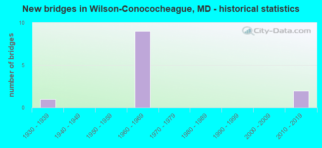
- New bridges - historical statistics
- 11930-1939
- 91960-1969
- 22010-2019

- Reconstructed bridges - Historical Statistics
- 31960-1969
- 01970-1979
- 01980-1989
- 01990-1999
- 12000-2009


- Bridge Condition - Deck
- 16.7%Very good
- 16.7%Good
- 50.0%Satisfactory
- 16.7%Fair

- Bridge Condition - Superstructure
- 33.3%Very good
- 16.7%Good
- 50.0%Satisfactory

- Bridge Condition - Substructure
- 16.7%Very good
- 33.3%Good
- 16.7%Satisfactory
- 33.3%Fair

- Bridge Condition - Channel
- 25.0%Very good
- 50.0%Good
- 25.0%Satisfactory
Find on map >> Show street view
Structure Number: 10000021001201, Location: 1.92 MILES EAST OF MD 57 (Lat: 39.657233, Lng: -77.848889), Route carried "on" structure: US 40, Year Built: 1936, Status: Open, Structure Length: 11.28m (37.01ft), Average Daily Traffic: 11,832 (year 2009), Truck Traffic: 8%, Average Future Daily Traffic: 16,156 (year 2026), Design Load: H 20, Features Intersected: CONOCOCHEAGUE CREEK
Minimum Vertical Clearance: 30+ m (98+ ft), Kilometerpoint: 46.532, Lanes on structure: 2, Base Highway Network: Yes, Owner: State Highway Agency, Approaching Roadway Width: 11.6m (38.1ft), Material/Design: Concrete, Design/Construction: Arch - Deck, Number Of Spans In Main Unit: 3, Length of Maximum Span: 31.1m (102.0ft), Curb or Sidewalk Widths: Left: 0.9m (3.0ft), Right: 0.9m (3.0ft), Curb-To-Curb Width: 13.4m (44.0ft), Out-to-Out Width: 16.2m (53.1ft)
Condition: Deck: Fair, Superstructure: Satisfactory, Substructure: Fair, Channel: Good, Operating Rating: 45.8 metric tons, Method Used To Determine Operating Rating: Load Factor (LF), Inventory Rating: 27.2 metric tons, Method Used To Determine Inventory Rating: Load Factor (LF), Structural Evaluation: Somewhat better than minimum adequacy, Deck Geometry: Equal to present minimum criteria, Waterway Adequacy: Superior to present desirable criteria, Approach Roadway Alignment: Equal to present desirable criteria, Designated Inspection Frequency: Every 24 months, Other Special Inspection Frequency: Every 12 months, Inspection Date: April 2020, Other Special Inspection Date: April 2021, Deck Structure Type: Concrete Cast-file-Place, Wearing Surface/Protective System: Wearing Surface: Monolithic Concrete
Find on map >> Show street view
Structure Number: 10000021010302, Location: 3.06 MILES EAST OF MD 68 (Lat: 39.650483, Lng: -77.865672), Route carried "on" structure: Interstate 70, Year Built: 1967, Status: Open, Structure Length: 2.44m (8.01ft), Average Daily Traffic: 40,770 (year 2009), Truck Traffic: 8%, Average Future Daily Traffic: 27,268 (year 2026), Design Load: HS 20, Features Intersected: MEADOW BROOK CREEK
Minimum Vertical Clearance: 30+ m (98+ ft), Kilometerpoint: 33.274, Lanes on structure: 2, Base Highway Network: Yes, Owner: State Highway Agency, Approaching Roadway Width: 11.6m (38.1ft), Skew: 3 degrees, Material/Design: Concrete, Design/Construction: Culvert, Length of Maximum Span: 3.7m (12.1ft)
Condition: Channel: Good, Culverts: Good, Structural Evaluation: Better than present minimum criteria, Waterway Adequacy: Equal to present desirable criteria, Approach Roadway Alignment: Equal to present desirable criteria, Designated Inspection Frequency: Every 24 months, Inspection Date: November 2021
Find on map >> Show street view
Structure Number: 10000021010402, Location: 2.95 MILES WEST OF MD 63 (Lat: 39.650367, Lng: -77.856969), Route carried "on" structure: Interstate 70, Year Built: 1967, Status: Open, Structure Length: 4.05m (13.29ft), Average Daily Traffic: 40,770 (year 2009), Truck Traffic: 8%, Average Future Daily Traffic: 27,268 (year 2026), Design Load: HS 20, Features Intersected: MEADOW BROOK CREEK
Minimum Vertical Clearance: 30+ m (98+ ft), Kilometerpoint: 34.046, Lanes on structure: 2, Base Highway Network: Yes, Owner: State Highway Agency, Approaching Roadway Width: 11.6m (38.1ft), Skew: 3 degrees, Material/Design: Concrete, Design/Construction: Culvert, Length of Maximum Span: 3.7m (12.1ft)
Condition: Channel: Satisfactory, Culverts: Good, Structural Evaluation: Better than present minimum criteria, Waterway Adequacy: Equal to present desirable criteria, Approach Roadway Alignment: Equal to present desirable criteria, Designated Inspection Frequency: Every 24 months, Inspection Date: November 2021
Find on map >> Show street view
Structure Number: 10000021010501, Location: 0.51 MI S OF US 40 (Lat: 39.650117, Lng: -77.852994), Route carried "on" structure: County highway 758, Year Built: 1967, Year Reconstructed: 1974, Status: Open, Structure Length: 3.78m (12.40ft), Average Daily Traffic: 1,344 (year 2016), Truck Traffic: 5%, Average Future Daily Traffic: 1,997 (year 2036), Design Load: H 20, Features Intersected: IS 70, Facility Carried by Structure: CEDAR RIDGE ROAD
Minimum Vertical Clearance: 30+ m (98+ ft), Kilometerpoint: 2.414, Lanes on structure: 2, Lanes under structure: 2, Owner: State Highway Agency, Approaching Roadway Width: 9.8m (32.2ft), Skew: 1 degrees, Material/Design: Steel, Design/Construction: Stringer/Multi-beam, Number Of Spans In Main Unit: 3, Length of Maximum Span: 17.4m (57.1ft), Curb-To-Curb Width: 9.1m (29.9ft), Out-to-Out Width: 10.7m (35.1ft)
Condition: Deck: Satisfactory, Superstructure: Good, Substructure: Good, Operating Rating: 56.2 metric tons, Method Used To Determine Operating Rating: Load Factor (LF), Inventory Rating: 33.6 metric tons, Method Used To Determine Inventory Rating: Load Factor (LF), Structural Evaluation: Better than present minimum criteria, Deck Geometry: Somewhat better than minimum adequacy, Underclear: Somewhat better than minimum adequacy, Approach Roadway Alignment: Equal to present desirable criteria, Designated Inspection Frequency: Every 24 months, Inspection Date: April 2020, Deck Structure Type: Concrete Cast-file-Place, Wearing Surface/Protective System: Wearing Surface: Bituminous
Find on map >> Show street view
Structure Number: 100000210106013, Location: 1.34 MILES WEST OF MD 63 (Lat: 39.641986, Lng: -77.830042), Route carried "on" structure: Interstate 70, Year Built: 1966, Year Reconstructed: 2014, Status: Open, Structure Length: 11.28m (37.01ft), Average Daily Traffic: 17,276 (year 2017), Truck Traffic: 14%, Average Future Daily Traffic: 23,435 (year 2037), Design Load: HS 20, Features Intersected: CONOCOCHEAGUE CREEK
Minimum Vertical Clearance: 30+ m (98+ ft), Kilometerpoint: 36.590, Lanes on structure: 2, Base Highway Network: Yes, Owner: State Highway Agency, Approaching Roadway Width: 15.9m (52.2ft), Material/Design: Steel continuous, Design/Construction: Stringer/Multi-beam, Number Of Spans In Main Unit: 4, Length of Maximum Span: 30.5m (100.1ft), Curb-To-Curb Width: 15.5m (50.9ft), Out-to-Out Width: 16.8m (55.1ft)
Condition: Deck: Good, Superstructure: Very good, Substructure: Good, Channel: Very good, Operating Rating: 48.6 metric tons, Method Used To Determine Operating Rating: Load and Resistance Factor Rating (LRFR) rating reported by rating factor(RF) method using HL-93 loadings, Inventory Rating: 38.9 metric tons, Method Used To Determine Inventory Rating: Load and Resistance Factor Rating (LRFR) rating reported by rating factor(RF) method using HL-93 loadings, Structural Evaluation: Better than present minimum criteria, Deck Geometry: Superior to present desirable criteria, Waterway Adequacy: Equal to present desirable criteria, Approach Roadway Alignment: Equal to present desirable criteria, Length Of Structure Improvement: 11.28m (37.01ft), Designated Inspection Frequency: Every 24 months, Inspection Date: July 2020, Bridge Improvement Cost: $793,000, Roadway Improvement Cost: $79,000, Total Project Cost: $872,000, Deck Structure Type: Concrete Cast-file-Place, Wearing Surface/Protective System: Wearing Surface: Integral Concrete, Deck Protection: Epoxy Coated Reinforcing
Find on map >> Show street view
Structure Number: 10000021010701, Location: 1.17 MILES S OF US 40 (Lat: 39.637250, Lng: -77.822233), Route carried "on" structure: County highway 110, Year Built: 1965, Year Reconstructed: 1973, Status: Open, Structure Length: 7.56m (24.80ft), Average Daily Traffic: 533 (year 2016), Truck Traffic: 5%, Average Future Daily Traffic: 880 (year 2036), Design Load: H 20, Features Intersected: IS 70, Facility Carried by Structure: WALNUT POINT RD
Minimum Vertical Clearance: 30+ m (98+ ft), Kilometerpoint: 1.239, Lanes on structure: 2, Lanes under structure: 4, Owner: State Highway Agency, Approaching Roadway Width: 7.9m (25.9ft), Skew: 3 degrees, Material/Design: Steel, Design/Construction: Stringer/Multi-beam, Number Of Spans In Main Unit: 4, Length of Maximum Span: 26.5m (86.9ft), Curb-To-Curb Width: 7.9m (25.9ft), Out-to-Out Width: 9.5m (31.2ft)
Condition: Deck: Satisfactory, Superstructure: Satisfactory, Substructure: Fair, Operating Rating: 51.7 metric tons, Method Used To Determine Operating Rating: Load Factor (LF), Inventory Rating: 30.8 metric tons, Method Used To Determine Inventory Rating: Load Factor (LF), Structural Evaluation: Somewhat better than minimum adequacy, Deck Geometry: Somewhat better than minimum adequacy, Underclear: Somewhat better than minimum adequacy, Approach Roadway Alignment: Equal to present desirable criteria, Designated Inspection Frequency: Every 24 months, Inspection Date: June 2020, Deck Structure Type: Concrete Cast-file-Place, Wearing Surface/Protective System: Wearing Surface: Bituminous
Find on map >> Show street view
Structure Number: 100000210108014, Location: 1.61 MILES WEST OF US 81 (Lat: 39.630150, Lng: -77.809236), Route carried "on" structure: Interstate 70, Year Built: 2014, Status: Open, Structure Length: 5.09m (16.70ft), Average Daily Traffic: 47,400 (year 2010), Truck Traffic: 26%, Average Future Daily Traffic: 64,600 (year 2030), Features Intersected: MD 63
Minimum Vertical Clearance: 30+ m (98+ ft), Kilometerpoint: 38.761, Lanes on structure: 2, Lanes under structure: 4, Base Highway Network: Yes, Owner: State Highway Agency, Approaching Roadway Width: 16.5m (54.1ft), Skew: 1 degrees, Material/Design: Steel continuous, Design/Construction: Stringer/Multi-beam, Number Of Spans In Main Unit: 2, Length of Maximum Span: 24.4m (80.1ft), Curb-To-Curb Width: 15.7m (51.5ft), Out-to-Out Width: 16.9m (55.4ft)
Condition: Deck: Very good, Superstructure: Very good, Substructure: Very good, Operating Rating: 90.1 metric tons, Method Used To Determine Operating Rating: Load and Resistance Factor Rating (LRFR) rating reported by rating factor(RF) method using HL-93 loadings, Inventory Rating: 69.3 metric tons, Method Used To Determine Inventory Rating: Load and Resistance Factor Rating (LRFR) rating reported by rating factor(RF) method using HL-93 loadings, Structural Evaluation: Equal to present desirable criteria, Deck Geometry: Superior to present desirable criteria, Underclear: Somewhat better than minimum adequacy, Approach Roadway Alignment: Equal to present desirable criteria, Designated Inspection Frequency: Every 24 months, Inspection Date: June 2020, Deck Structure Type: Concrete Cast-file-Place, Wearing Surface/Protective System: Wearing Surface: Monolithic Concrete, Deck Protection: Epoxy Coated Reinforcing
Find on map >> Show street view
Structure Number: 10000021014401, Location: 2.74 MI W OF MD 63 (Lat: 39.651300, Lng: -77.852672), Route carried "on" structure: County highway 758, Year Built: 1967, Year Reconstructed: 1974, Status: Open, Structure Length: 3.78m (12.40ft), Average Daily Traffic: 1,344 (year 2016), Truck Traffic: 5%, Average Future Daily Traffic: 1,997 (year 2036), Design Load: H 20, Features Intersected: IS 70, Facility Carried by Structure: CEDAR RIDGE ROAD
Minimum Vertical Clearance: 30+ m (98+ ft), Kilometerpoint: 2.414, Lanes on structure: 2, Lanes under structure: 2, Owner: State Highway Agency, Approaching Roadway Width: 9.8m (32.2ft), Skew: 1 degrees, Material/Design: Steel, Design/Construction: Stringer/Multi-beam, Number Of Spans In Main Unit: 3, Length of Maximum Span: 17.4m (57.1ft), Curb-To-Curb Width: 9.1m (29.9ft), Out-to-Out Width: 10.7m (35.1ft)
Condition: Deck: Satisfactory, Superstructure: Satisfactory, Substructure: Satisfactory, Operating Rating: 56.2 metric tons, Method Used To Determine Operating Rating: Load Factor (LF), Inventory Rating: 33.6 metric tons, Method Used To Determine Inventory Rating: Load Factor (LF), Structural Evaluation: Equal to present minimum criteria, Deck Geometry: Somewhat better than minimum adequacy, Underclear: Equal to present minimum criteria, Approach Roadway Alignment: Equal to present desirable criteria, Designated Inspection Frequency: Every 24 months, Inspection Date: April 2020, Deck Structure Type: Concrete Cast-file-Place, Wearing Surface/Protective System: Wearing Surface: Bituminous
Find on map >> Show street view
Structure Number: 10000021010501, Location: 0.51 MILE SOUTH OF US 40 (Lat: 39.650425, Lng: -77.852994), Route carried "under" structure: Interstate 70, Year Built: 1967, Structure Length: 0. m, Average Daily Traffic: 23,650 (year 2006), Truck Traffic: 8%, Features Intersected: IS 70 EBR, Facility Carried by Structure: CEDAR RIDGE ROAD
Minimum Vertical Clearance: 4.88m (16.01ft), Kilometerpoint: 34.384, Lanes on structure: 2, Lanes under structure: 2, Material/Design: Steel, Design/Construction: Stringer/Multi-beam, Length of Maximum Span: 17.4m (57.1ft)
Find on map >> Show street view
Structure Number: 10000021010701, Location: 0.85 MILE WEST OF MD 63 (Lat: 39.637269, Lng: -77.822300), Route carried "under" structure: Interstate 70, Year Built: 1965, Structure Length: 0. m, Average Daily Traffic: 40,770 (year 2009), Truck Traffic: 8%, Features Intersected: IS 70, Facility Carried by Structure: WALNUT POINT RD
Minimum Vertical Clearance: 4.88m (16.01ft), Kilometerpoint: 37.425, Lanes on structure: 2, Lanes under structure: 4, Material/Design: Steel, Design/Construction: Stringer/Multi-beam, Length of Maximum Span: 26.5m (86.9ft)
Find on map >> Show street view
Structure Number: 100000210108014, Location: 1.59 MILES SOUTH OF US 40 (Lat: 39.630150, Lng: -77.809236), Route carried "under" structure: State highway 63, Year Built: 2014, Structure Length: 0. m, Average Daily Traffic: 9,591 (year 2009), Truck Traffic: 8%, Features Intersected: MD 63, Facility Carried by Structure: IS 70 WBR
Minimum Vertical Clearance: 5.49m (18.01ft), Kilometerpoint: 16.396, Lanes on structure: 2, Lanes under structure: 4, Material/Design: Steel continuous, Design/Construction: Stringer/Multi-beam, Length of Maximum Span: 24.4m (80.1ft)
Find on map >> Show street view
Structure Number: 10000021014401, Location: 0.51 MILE SOUTH OF US 40 (Lat: 39.651269, Lng: -77.852692), Route carried "under" structure: Interstate 70, Year Built: 1967, Structure Length: 0. m, Average Daily Traffic: 40,770 (year 2009), Truck Traffic: 8%, Features Intersected: IS 70 WBR, Facility Carried by Structure: CEDAR RIDGE ROAD
Minimum Vertical Clearance: 4.88m (16.01ft), Kilometerpoint: 34.384, Lanes on structure: 2, Lanes under structure: 2, Material/Design: Steel, Design/Construction: Stringer/Multi-beam, Length of Maximum Span: 17.4m (57.1ft)