Bridge Statistics for Wilmington, Illinois (IL)
Condition, Traffic, Stress, Structural Evaluation, Project Costs
- National Bridge Inventory (NBI) Statistics
- 33Number of bridges
- 604ft / 184mTotal length
- $7,939,000Total costs
- 341,805Total average daily traffic
- 47,609Total average daily truck traffic
- National Bridge Inventory (NBI) Registered Bridges for Wilmington
- No street view available for this location
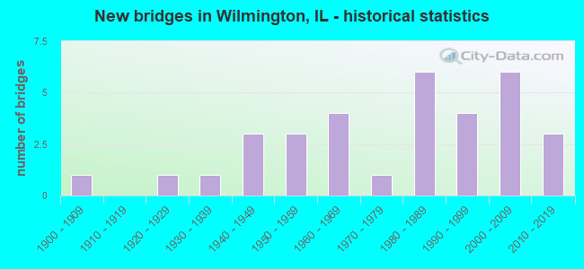
- New bridges - historical statistics
- 11900-1909
- 11920-1929
- 11930-1939
- 31940-1949
- 31950-1959
- 41960-1969
- 11970-1979
- 61980-1989
- 41990-1999
- 62000-2009
- 32010-2019

- Reconstructed bridges - Historical Statistics
- 11970-1979
- 01980-1989
- 31990-1999
- 32000-2009
- 52010-2019
- 12020-2022


- Bridge Condition - Deck
- 8.0%Excellent
- 16.0%Very good
- 36.0%Good
- 28.0%Satisfactory
- 12.0%Fair

- Bridge Condition - Superstructure
- 23.1%Very good
- 23.1%Good
- 26.9%Satisfactory
- 26.9%Fair

- Bridge Condition - Substructure
- 19.2%Very good
- 53.8%Good
- 7.7%Satisfactory
- 19.2%Fair

- Bridge Condition - Channel
- 3.8%Excellent
- 26.9%Very good
- 23.1%Good
- 30.8%Satisfactory
- 15.4%Fair
Find on map >> Show street view
Structure Number: 91500000003012, Location: 0.1 MILE EAST OF SR 53 (Lat: 41.354456, Lng: -88.133003), Route carried "on" structure: Federal lands road 2605A, Year Built: 1959, Status: Open, Structure Length: 3.12m (10.24ft), Average Daily Traffic: 5 (year 2008), Average Future Daily Traffic: 7 (year 2042), Features Intersected: PRAIRIE CREEK, Facility Carried by Structure: PERIMETER ROAD
Minimum Vertical Clearance: 30+ m (98+ ft), Kilometerpoint: 1.008, Lanes on structure: 1, Owner: U.S. Forest Service, Approaching Roadway Width: 3.7m (12.1ft), Material/Design: Steel, Design/Construction: Stringer/Multi-beam, Number Of Spans In Main Unit: 2, Length of Maximum Span: 15.2m (49.9ft), Curb or Sidewalk Widths: Left: 0.4m (1.3ft), Right: 0.4m (1.3ft), Curb-To-Curb Width: 3.7m (12.1ft), Out-to-Out Width: 4.4m (14.4ft)
Condition: Deck: Satisfactory, Superstructure: Satisfactory, Substructure: Fair, Channel: Fair, Operating Rating: 56.7 metric tons, Method Used To Determine Operating Rating: Load and Resistance Factor Rating (LRFR) rating reported by rating factor(RF) method using HL-93 loadings, Inventory Rating: 43.7 metric tons, Method Used To Determine Inventory Rating: Load and Resistance Factor Rating (LRFR) rating reported by rating factor(RF) method using HL-93 loadings, Structural Evaluation: Somewhat better than minimum adequacy, Deck Geometry: Meets minimum limits, Waterway Adequacy: Better than present minimum criteria, Approach Roadway Alignment: Equal to present desirable criteria, Designated Inspection Frequency: Every 24 months, Inspection Date: April 2021, Deck Structure Type: Concrete Cast-file-Place, Wearing Surface/Protective System: Wearing Surface: Monolithic Concrete
Find on map >> Show street view
Structure Number: 990001, Location: 7.4 M S OF US 6 (Lat: 41.350806, Lng: -88.191700), Route carried "on" structure: Interstate 55, Year Built: 1935, Year Reconstructed: 2010, Status: Open, Structure Length: 30.48m (100.00ft), Average Daily Traffic: 19,400 (year 2021), Truck Traffic: 15%, Average Future Daily Traffic: 23,400 (year 2032), Design Load: HS 20, Features Intersected: KANKAKEE RIVER
Minimum Vertical Clearance: 30+ m (98+ ft), Kilometerpoint: 387.825, Lanes on structure: 2, Base Highway Network: Yes, Owner: State Highway Agency, Approaching Roadway Width: 13.1m (43.0ft), Skew: 3 degrees, Material/Design: Prestressed concrete continuous, Design/Construction: Stringer/Multi-beam, Number Of Spans In Main Unit: 12, Length of Maximum Span: 25.5m (83.7ft), Curb-To-Curb Width: 11.8m (38.7ft), Out-to-Out Width: 12.8m (42.0ft)
Condition: Deck: Satisfactory, Superstructure: Satisfactory, Substructure: Good, Channel: Very good, Operating Rating: 49.6 metric tons, Method Used To Determine Operating Rating: Load Factor (LF) rating reported by rating factor (RF) method using MS18 loading, Inventory Rating: 29.5 metric tons, Method Used To Determine Inventory Rating: Load Factor (LF) rating reported by rating factor (RF) method using MS18 loading, Structural Evaluation: Equal to present minimum criteria, Deck Geometry: Equal to present minimum criteria, Waterway Adequacy: Equal to present desirable criteria, Approach Roadway Alignment: Equal to present desirable criteria, Designated Inspection Frequency: Every 24 months, Inspection Date: June 2021, Deck Structure Type: Concrete Cast-file-Place, Wearing Surface/Protective System: Wearing Surface: Latex Concrete, Deck Protection: Epoxy Coated Reinforcing
Find on map >> Show street view
Structure Number: 990002, Location: 7.4 M S OF US 6 (Lat: 41.351081, Lng: -88.191706), Route carried "on" structure: Interstate 55, Year Built: 1956, Year Reconstructed: 2010, Status: Open, Structure Length: 30.64m (100.52ft), Average Daily Traffic: 19,400 (year 2021), Truck Traffic: 15%, Average Future Daily Traffic: 23,400 (year 2032), Design Load: HS 20, Features Intersected: KANKAKEE RIVER
Minimum Vertical Clearance: 30+ m (98+ ft), Kilometerpoint: 387.841, Lanes on structure: 2, Base Highway Network: Yes, Owner: State Highway Agency, Approaching Roadway Width: 13.2m (43.3ft), Skew: 3 degrees, Material/Design: Prestressed concrete continuous, Design/Construction: Stringer/Multi-beam, Number Of Spans In Main Unit: 12, Length of Maximum Span: 25.5m (83.7ft), Curb-To-Curb Width: 12.2m (40.0ft), Out-to-Out Width: 13.2m (43.3ft)
Condition: Deck: Satisfactory, Superstructure: Satisfactory, Substructure: Good, Channel: Very good, Operating Rating: 45.7 metric tons, Method Used To Determine Operating Rating: Load Factor (LF) rating reported by rating factor (RF) method using MS18 loading, Inventory Rating: 27.5 metric tons, Method Used To Determine Inventory Rating: Load Factor (LF) rating reported by rating factor (RF) method using MS18 loading, Structural Evaluation: Equal to present minimum criteria, Deck Geometry: Better than present minimum criteria, Waterway Adequacy: Equal to present desirable criteria, Approach Roadway Alignment: Equal to present desirable criteria, Length Of Structure Improvement: 30.63m (100.49ft), Designated Inspection Frequency: Every 24 months, Inspection Date: June 2021, Bridge Improvement Cost: $3,127,000, Roadway Improvement Cost: $313,000, Total Project Cost: $4,691,000, Deck Structure Type: Concrete Cast-file-Place, Wearing Surface/Protective System: Wearing Surface: Latex Concrete, Deck Protection: Epoxy Coated Reinforcing
Find on map >> Show street view
Structure Number: 990005, Location: 5.6 M S OF US 6 (Lat: 41.375722, Lng: -88.192364), Route carried "on" structure: Interstate 55, Year Built: 1956, Year Reconstructed: 2019, Status: Open, Structure Length: 5.42m (17.78ft), Average Daily Traffic: 21,600 (year 2021), Truck Traffic: 8%, Average Future Daily Traffic: 36,073 (year 2032), Design Load: HS 20, Features Intersected: GRANT CREEK
Minimum Vertical Clearance: 30+ m (98+ ft), Kilometerpoint: 390.529, Lanes on structure: 2, Base Highway Network: Yes, Owner: State Highway Agency, Approaching Roadway Width: 12.2m (40.0ft), Skew: 2 degrees, Material/Design: Steel continuous, Design/Construction: Stringer/Multi-beam, Number Of Spans In Main Unit: 3, Length of Maximum Span: 21.3m (69.9ft), Curb-To-Curb Width: 12.2m (40.0ft), Out-to-Out Width: 13.0m (42.7ft)
Condition: Deck: Very good, Superstructure: Fair, Substructure: Very good, Channel: Satisfactory, Operating Rating: 76.8 metric tons, Method Used To Determine Operating Rating: Load Factor (LF) rating reported by rating factor (RF) method using MS18 loading, Inventory Rating: 40.2 metric tons, Method Used To Determine Inventory Rating: Load Factor (LF) rating reported by rating factor (RF) method using MS18 loading, Structural Evaluation: Somewhat better than minimum adequacy, Deck Geometry: Better than present minimum criteria, Waterway Adequacy: Equal to present desirable criteria, Approach Roadway Alignment: Better than present minimum criteria, Designated Inspection Frequency: Every 24 months, Inspection Date: Febuary 2021, Deck Structure Type: Concrete Cast-file-Place, Wearing Surface/Protective System: Deck Protection: Epoxy Coated Reinforcing
Find on map >> Show street view
Structure Number: 99009, Location: 4.0 MI N OF ILL 102 (Lat: 41.354661, Lng: -88.133867), Route carried "on" structure: State highway 53, Year Built: 1942, Year Reconstructed: 2008, Status: Open, Structure Length: 3.35m (10.99ft), Average Daily Traffic: 5,850 (year 2021), Truck Traffic: 12%, Average Future Daily Traffic: 5,263 (year 2032), Design Load: H 20, Features Intersected: PRAIRIE CREEK
Minimum Vertical Clearance: 30+ m (98+ ft), Kilometerpoint: 27.793, Lanes on structure: 2, Base Highway Network: Yes, Owner: State Highway Agency, Approaching Roadway Width: 12.2m (40.0ft), Material/Design: Steel continuous, Design/Construction: Stringer/Multi-beam, Number Of Spans In Main Unit: 3, Length of Maximum Span: 12.6m (41.3ft), Curb-To-Curb Width: 12.2m (40.0ft), Out-to-Out Width: 12.9m (42.3ft)
Condition: Deck: Good, Superstructure: Very good, Substructure: Fair, Channel: Good, Operating Rating: 89.1 metric tons, Method Used To Determine Operating Rating: Load Factor (LF) rating reported by rating factor (RF) method using MS18 loading, Inventory Rating: 70.0 metric tons, Method Used To Determine Inventory Rating: Load Factor (LF) rating reported by rating factor (RF) method using MS18 loading, Structural Evaluation: Somewhat better than minimum adequacy, Deck Geometry: Better than present minimum criteria, Waterway Adequacy: Equal to present desirable criteria, Approach Roadway Alignment: Equal to present desirable criteria, Length Of Structure Improvement: 4.33m (14.21ft), Designated Inspection Frequency: Every 24 months, Inspection Date: Febuary 2021, Bridge Improvement Cost: $472,000, Roadway Improvement Cost: $47,000, Total Project Cost: $708,000, Deck Structure Type: Concrete Cast-file-Place, Wearing Surface/Protective System: Deck Protection: Epoxy Coated Reinforcing
Find on map >> Show street view
Structure Number: 990091, Location: 0.6 M E OF IL 102 (Lat: 41.310789, Lng: -88.137106), Route carried "on" structure: State highway 53, Year Built: 1922, Year Reconstructed: 1981, Status: Open, Structure Length: 2.93m (9.61ft), Average Daily Traffic: 8,750 (year 2021), Truck Traffic: 6%, Average Future Daily Traffic: 13,142 (year 2032), Design Load: HS 20, Features Intersected: FORKED CREEK
Minimum Vertical Clearance: 30+ m (98+ ft), Kilometerpoint: 22.562, Lanes on structure: 2, Base Highway Network: Yes, Owner: State Highway Agency, Approaching Roadway Width: 12.2m (40.0ft), Material/Design: Steel continuous, Design/Construction: Stringer/Multi-beam, Number Of Spans In Main Unit: 2, Length of Maximum Span: 14.4m (47.2ft), Curb-To-Curb Width: 12.2m (40.0ft), Out-to-Out Width: 13.2m (43.3ft)
Condition: Deck: Satisfactory, Superstructure: Good, Substructure: Good, Channel: Fair, Operating Rating: 73.9 metric tons, Method Used To Determine Operating Rating: Load Factor (LF) rating reported by rating factor (RF) method using MS18 loading, Inventory Rating: 39.5 metric tons, Method Used To Determine Inventory Rating: Load Factor (LF) rating reported by rating factor (RF) method using MS18 loading, Structural Evaluation: Better than present minimum criteria, Deck Geometry: Somewhat better than minimum adequacy, Waterway Adequacy: Equal to present minimum criteria, Approach Roadway Alignment: Equal to present desirable criteria, Designated Inspection Frequency: Every 24 months, Inspection Date: August 2021, Deck Structure Type: Concrete Cast-file-Place, Wearing Surface/Protective System: Wearing Surface: Latex Concrete, Deck Protection: Epoxy Coated Reinforcing
Find on map >> Show street view
Structure Number: 990092, Location: 0.1 M W OF IL 102 (Lat: 41.307633, Lng: -88.147556), Route carried "on" structure: State highway 53, Year Built: 1944, Year Reconstructed: 1998, Status: Open, Structure Length: 1.98m (6.50ft), Average Daily Traffic: 11,500 (year 2021), Truck Traffic: 4%, Average Future Daily Traffic: 13,142 (year 2032), Design Load: H 20, Features Intersected: KKK RIVER MILL RACE
Minimum Vertical Clearance: 30+ m (98+ ft), Kilometerpoint: 21.629, Lanes on structure: 2, Base Highway Network: Yes, Owner: State Highway Agency, Approaching Roadway Width: 12.1m (39.7ft), Material/Design: Steel, Design/Construction: Stringer/Multi-beam, Number Of Spans In Main Unit: 1, Length of Maximum Span: 18.7m (61.4ft), Curb or Sidewalk Widths: Left: 1.4m (4.6ft), Right: 1.6m (5.2ft), Curb-To-Curb Width: 12.1m (39.7ft), Out-to-Out Width: 15.9m (52.2ft)
Condition: Deck: Good, Superstructure: Good, Substructure: Fair, Channel: Very good, Operating Rating: 61.2 metric tons, Method Used To Determine Operating Rating: Load Factor (LF) rating reported by rating factor (RF) method using MS18 loading, Inventory Rating: 36.9 metric tons, Method Used To Determine Inventory Rating: Load Factor (LF) rating reported by rating factor (RF) method using MS18 loading, Structural Evaluation: Somewhat better than minimum adequacy, Deck Geometry: Somewhat better than minimum adequacy, Waterway Adequacy: Somewhat better than minimum adequacy, Approach Roadway Alignment: Better than present minimum criteria, Length Of Structure Improvement: 2.77m (9.09ft), Designated Inspection Frequency: Every 24 months, Underwater Inspection Frequency: Every 60 months, Inspection Date: June 2021, Underwater Inspection Date: September 2019, Bridge Improvement Cost: $354,000, Roadway Improvement Cost: $35,000, Total Project Cost: $531,000, Deck Structure Type: Concrete Cast-file-Place, Wearing Surface/Protective System: Deck Protection: Epoxy Coated Reinforcing
Find on map >> Show street view
Structure Number: 990181, Location: 0.25 Mi West of I-55 (Lat: 41.377631, Lng: -88.195286), Route carried "on" structure: Other road , Year Built: 1961, Year Reconstructed: 2015, Status: Open, Structure Length: 3.21m (10.53ft), Average Daily Traffic: 425 (year 2019), Truck Traffic: 3%, Average Future Daily Traffic: 1,944 (year 2032), Design Load: HS 20, Features Intersected: GRANT CREEK, Facility Carried by Structure: BLODGETT RD
Minimum Vertical Clearance: 30+ m (98+ ft), Kilometerpoint: 0.274, Lanes on structure: 2, Owner: State Highway Agency, Approaching Roadway Width: 11.0m (36.1ft), Skew: 2 degrees, Material/Design: Steel continuous, Design/Construction: Stringer/Multi-beam, Number Of Spans In Main Unit: 3, Length of Maximum Span: 11.9m (39.0ft), Curb-To-Curb Width: 9.1m (29.9ft), Out-to-Out Width: 9.4m (30.8ft)
Condition: Deck: Good, Superstructure: Fair, Substructure: Good, Channel: Satisfactory, Operating Rating: 57.7 metric tons, Method Used To Determine Operating Rating: Load Factor (LF) rating reported by rating factor (RF) method using MS18 loading, Inventory Rating: 34.3 metric tons, Method Used To Determine Inventory Rating: Load Factor (LF) rating reported by rating factor (RF) method using MS18 loading, Structural Evaluation: Somewhat better than minimum adequacy, Deck Geometry: Equal to present minimum criteria, Waterway Adequacy: Equal to present desirable criteria, Approach Roadway Alignment: Better than present minimum criteria, Length Of Structure Improvement: 3.20m (10.50ft), Designated Inspection Frequency: Every 24 months, Inspection Date: April 2021, Bridge Improvement Cost: $257,000, Roadway Improvement Cost: $26,000, Total Project Cost: $386,000, Deck Structure Type: Concrete Cast-file-Place, Wearing Surface/Protective System: Deck Protection: Epoxy Coated Reinforcing
Find on map >> Show street view
Structure Number: 990193, Location: 2.0 M N IL 129 (Lat: 41.344144, Lng: -88.191747), Route carried "on" structure: County highway , Year Built: 1960, Year Reconstructed: 2002, Status: Open, Structure Length: 8.25m (27.07ft), Average Daily Traffic: 9,600 (year 2019), Truck Traffic: 27%, Average Future Daily Traffic: 8,314 (year 2032), Design Load: HS 20, Features Intersected: I- 55, Facility Carried by Structure: LORENZO ROAD
Minimum Vertical Clearance: 30+ m (98+ ft), Kilometerpoint: 4.812, Lanes on structure: 2, Lanes under structure: 4, Base Highway Network: Yes, Owner: State Highway Agency, Approaching Roadway Width: 16.2m (53.1ft), Skew: 24 degrees, Material/Design: Steel continuous, Design/Construction: Stringer/Multi-beam, Number Of Spans In Main Unit: 4, Length of Maximum Span: 23.9m (78.4ft), Curb-To-Curb Width: 16.2m (53.1ft), Out-to-Out Width: 17.8m (58.4ft)
Condition: Deck: Good, Superstructure: Good, Substructure: Good, Operating Rating: 84.2 metric tons, Method Used To Determine Operating Rating: Load Factor (LF) rating reported by rating factor (RF) method using MS18 loading, Inventory Rating: 50.2 metric tons, Method Used To Determine Inventory Rating: Load Factor (LF) rating reported by rating factor (RF) method using MS18 loading, Structural Evaluation: Better than present minimum criteria, Deck Geometry: Superior to present desirable criteria, Underclear: High priority of corrective action, Approach Roadway Alignment: Equal to present desirable criteria, Length Of Structure Improvement: 8.38m (27.49ft), Designated Inspection Frequency: Every 24 months, Inspection Date: December 2020, Bridge Improvement Cost: $599,000, Roadway Improvement Cost: $60,000, Total Project Cost: $899,000, Deck Structure Type: Concrete Cast-file-Place, Wearing Surface/Protective System: Deck Protection: Epoxy Coated Reinforcing
Find on map >> Show street view
Structure Number: 990242, Location: 4.0 M N OF IL 102 (Lat: 41.354811, Lng: -88.133872), Route carried "on" structure: State highway 53, Year Built: 1978, Year Reconstructed: 2008, Status: Open, Structure Length: 3.34m (10.96ft), Average Daily Traffic: 5,850 (year 2021), Truck Traffic: 12%, Average Future Daily Traffic: 5,263 (year 2032), Design Load: HS 20, Features Intersected: PRAIRIE CREEK
Minimum Vertical Clearance: 30+ m (98+ ft), Kilometerpoint: 27.809, Lanes on structure: 2, Base Highway Network: Yes, Owner: State Highway Agency, Approaching Roadway Width: 12.2m (40.0ft), Material/Design: Steel continuous, Design/Construction: Stringer/Multi-beam, Number Of Spans In Main Unit: 3, Length of Maximum Span: 10.8m (35.4ft), Curb-To-Curb Width: 12.2m (40.0ft), Out-to-Out Width: 13.2m (43.3ft)
Condition: Deck: Good, Superstructure: Very good, Substructure: Fair, Channel: Good, Operating Rating: 89.1 metric tons, Method Used To Determine Operating Rating: Load Factor (LF) rating reported by rating factor (RF) method using MS18 loading, Inventory Rating: 61.6 metric tons, Method Used To Determine Inventory Rating: Load Factor (LF) rating reported by rating factor (RF) method using MS18 loading, Structural Evaluation: Somewhat better than minimum adequacy, Deck Geometry: Better than present minimum criteria, Waterway Adequacy: Equal to present desirable criteria, Approach Roadway Alignment: Equal to present desirable criteria, Designated Inspection Frequency: Every 24 months, Inspection Date: Febuary 2021, Deck Structure Type: Concrete Cast-file-Place, Wearing Surface/Protective System: Deck Protection: Epoxy Coated Reinforcing
Find on map >> Show street view
Structure Number: 990272, Location: 0.3 M W OF IL 102 (Lat: 41.305811, Lng: -88.150442), Route carried "on" structure: State highway 53, Year Built: 1987, Status: Open, Structure Length: 18.36m (60.24ft), Average Daily Traffic: 11,500 (year 2021), Truck Traffic: 4%, Average Future Daily Traffic: 13,142 (year 2032), Design Load: HS 20, Features Intersected: KANKAKEE RIVER
Minimum Vertical Clearance: 30+ m (98+ ft), Kilometerpoint: 21.307, Lanes on structure: 2, Base Highway Network: Yes, Owner: State Highway Agency, Approaching Roadway Width: 9.8m (32.2ft), Skew: 1 degrees, Material/Design: Steel continuous, Design/Construction: Stringer/Multi-beam, Number Of Spans In Main Unit: 4, Length of Maximum Span: 49.8m (163.4ft), Curb or Sidewalk Widths: Left: 1.5m (4.9ft), Right: 1.5m (4.9ft), Curb-To-Curb Width: 9.8m (32.2ft), Out-to-Out Width: 14.3m (46.9ft)
Condition: Deck: Good, Superstructure: Satisfactory, Substructure: Good, Channel: Good, Operating Rating: 71.9 metric tons, Method Used To Determine Operating Rating: Load Factor (LF) rating reported by rating factor (RF) method using MS18 loading, Inventory Rating: 43.4 metric tons, Method Used To Determine Inventory Rating: Load Factor (LF) rating reported by rating factor (RF) method using MS18 loading, Structural Evaluation: Equal to present minimum criteria, Deck Geometry: Meets minimum limits, Waterway Adequacy: Better than present minimum criteria, Approach Roadway Alignment: Equal to present desirable criteria, Designated Inspection Frequency: Every 24 months, Inspection Date: Febuary 2021, Deck Structure Type: Concrete Cast-file-Place, Wearing Surface/Protective System: Wearing Surface: Latex Concrete, Deck Protection: Epoxy Coated Reinforcing
Find on map >> Show street view
Structure Number: 990286, Location: 5.7 M S OF US 6 (Lat: 41.374403, Lng: -88.192331), Route carried "on" structure: Interstate 55, Year Built: 1996, Year Reconstructed: 2020, Status: Open, Structure Length: 20.25m (66.44ft), Average Daily Traffic: 21,600 (year 2021), Truck Traffic: 8%, Average Future Daily Traffic: 36,073 (year 2032), Design Load: HS 20+Mod, Features Intersected: RR - BNSF & CREEK
Minimum Vertical Clearance: 30.40m (99.74ft), Kilometerpoint: 390.384, Lanes on structure: 2, Base Highway Network: Yes, Owner: State Highway Agency, Approaching Roadway Width: 12.2m (40.0ft), Material/Design: Steel continuous, Design/Construction: Stringer/Multi-beam, Number Of Spans In Main Unit: 5, Length of Maximum Span: 48.8m (160.1ft), Curb-To-Curb Width: 12.2m (40.0ft), Out-to-Out Width: 13.0m (42.7ft)
Condition: Deck: Excellent, Superstructure: Fair, Substructure: Good, Channel: Satisfactory, Operating Rating: 52.5 metric tons, Method Used To Determine Operating Rating: Load Factor (LF) rating reported by rating factor (RF) method using MS18 loading, Inventory Rating: 31.4 metric tons, Method Used To Determine Inventory Rating: Load Factor (LF) rating reported by rating factor (RF) method using MS18 loading, Structural Evaluation: Somewhat better than minimum adequacy, Deck Geometry: Better than present minimum criteria, Underclear: Equal to present desirable criteria, Waterway Adequacy: Equal to present desirable criteria, Approach Roadway Alignment: Better than present minimum criteria, Designated Inspection Frequency: Every 24 months, Inspection Date: Febuary 2021, Deck Structure Type: Concrete Cast-file-Place, Wearing Surface/Protective System: Deck Protection: Epoxy Coated Reinforcing
Find on map >> Show street view
Structure Number: 990304, Location: 5.7 M S OF US 6 (Lat: 41.373961, Lng: -88.192317), Route carried "on" structure: Interstate 55, Year Built: 1993, Year Reconstructed: 2019, Status: Open, Structure Length: 16.63m (54.56ft), Average Daily Traffic: 21,600 (year 2021), Truck Traffic: 8%, Average Future Daily Traffic: 36,073 (year 2032), Design Load: HS 20+Mod, Features Intersected: RR - BNSF
Minimum Vertical Clearance: 30+ m (98+ ft), Kilometerpoint: 390.336, Lanes on structure: 2, Base Highway Network: Yes, Owner: State Highway Agency, Approaching Roadway Width: 12.2m (40.0ft), Material/Design: Steel continuous, Design/Construction: Stringer/Multi-beam, Number Of Spans In Main Unit: 4, Length of Maximum Span: 48.8m (160.1ft), Curb-To-Curb Width: 12.2m (40.0ft), Out-to-Out Width: 13.0m (42.7ft)
Condition: Deck: Excellent, Superstructure: Fair, Substructure: Good, Operating Rating: 56.7 metric tons, Method Used To Determine Operating Rating: Load Factor (LF) rating reported by rating factor (RF) method using MS18 loading, Inventory Rating: 34.0 metric tons, Method Used To Determine Inventory Rating: Load Factor (LF) rating reported by rating factor (RF) method using MS18 loading, Structural Evaluation: Somewhat better than minimum adequacy, Deck Geometry: Better than present minimum criteria, Underclear: Meets minimum limits, Approach Roadway Alignment: Better than present minimum criteria, Designated Inspection Frequency: Every 24 months, Inspection Date: Febuary 2021, Deck Structure Type: Concrete Cast-file-Place, Wearing Surface/Protective System: Deck Protection: Epoxy Coated Reinforcing
Find on map >> Show street view
Structure Number: 993029, Location: 0.05M N.WILM-PEOTONE (Lat: 41.321583, Lng: -88.074564), Route carried "on" structure: County highway , Year Built: 2014, Status: Open, Structure Length: 2.07m (6.79ft), Average Daily Traffic: 900 (year 2019), Truck Traffic: 34%, Average Future Daily Traffic: 134 (year 2032), Design Load: HS 25 or greater, Features Intersected: JORDAN CREEK, Facility Carried by Structure: OLD CHICAGO RD (CH
Minimum Vertical Clearance: 30+ m (98+ ft), Kilometerpoint: 1.577, Lanes on structure: 3, Owner: County Highway Agency, Approaching Roadway Width: 18.3m (60.0ft), Skew: 23 degrees, Material/Design: Steel, Design/Construction: Stringer/Multi-beam, Number Of Spans In Main Unit: 1, Length of Maximum Span: 18.6m (61.0ft), Curb-To-Curb Width: 18.3m (60.0ft), Out-to-Out Width: 19.3m (63.3ft)
Condition: Deck: Very good, Superstructure: Very good, Substructure: Very good, Channel: Excellent, Operating Rating: 42.1 metric tons, Method Used To Determine Operating Rating: Assigned ratings based on Load and Resistance Factor Design (LRFD) reported by rating factor (RF) using HL93 loadings, Inventory Rating: 32.4 metric tons, Method Used To Determine Inventory Rating: Assigned ratings based on Load and Resistance Factor Design (LRFD) reported by rating factor (RF) using HL93 loadings, Structural Evaluation: Equal to present desirable criteria, Deck Geometry: Superior to present desirable criteria, Waterway Adequacy: Superior to present desirable criteria, Approach Roadway Alignment: Equal to present desirable criteria, Designated Inspection Frequency: Every 48 months, Inspection Date: April 2021, Deck Structure Type: Concrete Cast-file-Place, Wearing Surface/Protective System: Deck Protection: Epoxy Coated Reinforcing
Find on map >> Show street view
Structure Number: 993042, Location: 2.95M E IL ROUTE 53 (Lat: 41.337167, Lng: -88.174008), Route carried "on" structure: Other road , Year Built: 2012, Status: Open, Structure Length: 1.77m (5.81ft), Average Daily Traffic: 9,250 (year 2019), Truck Traffic: 29%, Average Future Daily Traffic: 2,146 (year 2032), Design Load: HS 25 or greater, Features Intersected: JORDAN CREEK, Facility Carried by Structure: WILMINGTON-PEOTONE
Minimum Vertical Clearance: 30+ m (98+ ft), Kilometerpoint: 5.584, Lanes on structure: 2, Base Highway Network: Yes, Owner: County Highway Agency, Approaching Roadway Width: 17.1m (56.1ft), Material/Design: Steel, Design/Construction: Stringer/Multi-beam, Number Of Spans In Main Unit: 1, Length of Maximum Span: 15.8m (51.8ft), Curb-To-Curb Width: 18.3m (60.0ft), Out-to-Out Width: 19.3m (63.3ft)
Condition: Deck: Very good, Superstructure: Very good, Substructure: Very good, Channel: Very good, Operating Rating: 44.1 metric tons, Method Used To Determine Operating Rating: Assigned rating based on Load Factor Design (LFD) reported by rating factor (RF) using MS18 loading, Inventory Rating: 32.4 metric tons, Method Used To Determine Inventory Rating: Assigned rating based on Load Factor Design (LFD) reported by rating factor (RF) using MS18 loading, Structural Evaluation: Equal to present desirable criteria, Deck Geometry: Superior to present desirable criteria, Waterway Adequacy: Equal to present desirable criteria, Approach Roadway Alignment: Equal to present desirable criteria, Designated Inspection Frequency: Every 48 months, Inspection Date: July 2018, Deck Structure Type: Concrete Cast-file-Place, Wearing Surface/Protective System: Deck Protection: Epoxy Coated Reinforcing
Find on map >> Show street view
Structure Number: 993246, Location: 0.4 MI E IL-102 (Lat: 41.276825, Lng: -88.121953), Route carried "on" structure: County highway , Year Built: 1943, Year Reconstructed: 1996, Status: Posted for load, Structure Length: 3.29m (10.79ft), Average Daily Traffic: 325 (year 2019), Truck Traffic: 10%, Average Future Daily Traffic: 268 (year 2032), Design Load: H 15, Features Intersected: FORKED CREEK, Facility Carried by Structure: BALLOU RD
Minimum Vertical Clearance: 30+ m (98+ ft), Kilometerpoint: 0.451, Lanes on structure: 2, Owner: Town or Township Highway Agency, Approaching Roadway Width: 6.1m (20.0ft), Material/Design: Concrete continuous, Design/Construction: Tee Beam, Number Of Spans In Main Unit: 2, Length of Maximum Span: 15.8m (51.8ft), Curb-To-Curb Width: 6.7m (22.0ft), Out-to-Out Width: 8.0m (26.2ft)
Condition: Deck: Good, Superstructure: Good, Substructure: Good, Channel: Good, Operating Rating: 24.9 metric tons, Method Used To Determine Operating Rating: Load Factor (LF) rating reported by rating factor (RF) method using MS18 loading, Inventory Rating: 14.9 metric tons, Method Used To Determine Inventory Rating: Load Factor (LF) rating reported by rating factor (RF) method using MS18 loading, Structural Evaluation: Meets minimum limits, Deck Geometry: Meets minimum limits, Waterway Adequacy: Equal to present minimum criteria, Approach Roadway Alignment: Equal to present desirable criteria, Bridge Posting: Required (Relationship of Operating Rating to Maximum Legal Load: 20.0 - 29.9% below), Designated Inspection Frequency: Every 24 months, Inspection Date: July 2020, Deck Structure Type: Concrete Cast-file-Place
Find on map >> Show street view
Structure Number: 993294, Location: 1 M E. I55(NW WILMGT (Lat: 41.342311, Lng: -88.182439), Route carried "on" structure: Other road , Year Built: 1969, Year Reconstructed: 2012, Status: Open, Structure Length: 2.65m (8.69ft), Average Daily Traffic: 9,250 (year 2019), Truck Traffic: 29%, Average Future Daily Traffic: 6,571 (year 2032), Design Load: HS 25 or greater, Features Intersected: PRAIRIE CREEK, Facility Carried by Structure: NEW RIVER ROAD
Minimum Vertical Clearance: 30+ m (98+ ft), Kilometerpoint: 4.587, Lanes on structure: 2, Base Highway Network: Yes, Owner: County Highway Agency, Approaching Roadway Width: 13.0m (42.7ft), Material/Design: Concrete continuous, Design/Construction: Slab, Number Of Spans In Main Unit: 3, Length of Maximum Span: 10.4m (34.1ft), Curb-To-Curb Width: 13.4m (44.0ft), Out-to-Out Width: 14.2m (46.6ft)
Condition: Deck: Very good, Superstructure: Very good, Substructure: Good, Channel: Very good, Operating Rating: 53.8 metric tons, Method Used To Determine Operating Rating: Load Factor (LF) rating reported by rating factor (RF) method using MS18 loading, Inventory Rating: 32.4 metric tons, Method Used To Determine Inventory Rating: Load Factor (LF) rating reported by rating factor (RF) method using MS18 loading, Structural Evaluation: Better than present minimum criteria, Deck Geometry: Equal to present minimum criteria, Waterway Adequacy: Equal to present desirable criteria, Approach Roadway Alignment: Equal to present desirable criteria, Designated Inspection Frequency: Every 48 months, Inspection Date: April 2019, Deck Structure Type: Concrete Cast-file-Place, Wearing Surface/Protective System: Wearing Surface: Bituminous, Membrane: Built-up
Find on map >> Show street view
Structure Number: 993331, Location: 0.3M.E.OFIL-53 (Lat: 41.320339, Lng: -88.126681), Route carried "on" structure: Other road , Year Built: 1988, Status: Open, Structure Length: 1.40m (4.59ft), Average Daily Traffic: 6,650 (year 2019), Truck Traffic: 20%, Average Future Daily Traffic: 2,146 (year 2032), Design Load: HS 20, Features Intersected: FORKED CREEK, Facility Carried by Structure: WIL-PEO RD.
Minimum Vertical Clearance: 30+ m (98+ ft), Kilometerpoint: 10.895, Lanes on structure: 2, Base Highway Network: Yes, Owner: County Highway Agency, Approaching Roadway Width: 9.8m (32.2ft), Material/Design: Prestressed concrete, Design/Construction: Box Beam or Girders - Multiple, Number Of Spans In Main Unit: 1, Length of Maximum Span: 13.0m (42.7ft), Curb-To-Curb Width: 12.2m (40.0ft), Out-to-Out Width: 12.2m (40.0ft)
Condition: Deck: Fair, Superstructure: Fair, Substructure: Very good, Channel: Good, Operating Rating: 49.6 metric tons, Method Used To Determine Operating Rating: Load Factor (LF) rating reported by rating factor (RF) method using MS18 loading, Inventory Rating: 29.8 metric tons, Method Used To Determine Inventory Rating: Load Factor (LF) rating reported by rating factor (RF) method using MS18 loading, Structural Evaluation: Somewhat better than minimum adequacy, Deck Geometry: Somewhat better than minimum adequacy, Waterway Adequacy: Equal to present desirable criteria, Approach Roadway Alignment: Equal to present desirable criteria, Designated Inspection Frequency: Every 24 months, Inspection Date: March 2021, Deck Structure Type: Concrete Precast Panels, Wearing Surface/Protective System: Wearing Surface: Bituminous, Membrane: Built-up
Find on map >> Show street view
Structure Number: 994641, Location: 2.5 M N IL-129 (Lat: 41.352469, Lng: -88.192381), Route carried "on" structure: Other road , Year Built: 2003, Status: Open, Structure Length: 6.54m (21.46ft), Average Daily Traffic: 9,250 (year 2019), Truck Traffic: 29%, Average Future Daily Traffic: 6,571 (year 2032), Design Load: HS 20, Features Intersected: I- 55, Facility Carried by Structure: WILMINGTON/RIVER R
Minimum Vertical Clearance: 30+ m (98+ ft), Kilometerpoint: 3.203, Lanes on structure: 2, Lanes under structure: 4, Base Highway Network: Yes, Owner: State Highway Agency, Approaching Roadway Width: 16.4m (53.8ft), Skew: 30 degrees, Material/Design: Steel continuous, Design/Construction: Stringer/Multi-beam, Number Of Spans In Main Unit: 2, Length of Maximum Span: 34.4m (112.9ft), Curb-To-Curb Width: 16.4m (53.8ft), Out-to-Out Width: 18.5m (60.7ft)
Condition: Deck: Good, Superstructure: Good, Substructure: Good, Operating Rating: 72.6 metric tons, Method Used To Determine Operating Rating: Load Factor (LF) rating reported by rating factor (RF) method using MS18 loading, Inventory Rating: 43.4 metric tons, Method Used To Determine Inventory Rating: Load Factor (LF) rating reported by rating factor (RF) method using MS18 loading, Structural Evaluation: Better than present minimum criteria, Deck Geometry: Superior to present desirable criteria, Underclear: Equal to present minimum criteria, Approach Roadway Alignment: Equal to present desirable criteria, Designated Inspection Frequency: Every 24 months, Inspection Date: April 2021, Deck Structure Type: Concrete Cast-file-Place, Wearing Surface/Protective System: Deck Protection: Epoxy Coated Reinforcing
Find on map >> Show street view
Structure Number: 994802, Location: 1.5 MI E IL 53 (Lat: 41.309700, Lng: -88.116739), Route carried "on" structure: County highway , Year Built: 1981, Status: Open, Structure Length: 0.84m (2.76ft), Average Daily Traffic: 250 (year 2016), Truck Traffic: 9%, Average Future Daily Traffic: 101 (year 2032), Features Intersected: JORDAN CR, Facility Carried by Structure: ALLOTT DR
Minimum Vertical Clearance: 30+ m (98+ ft), Kilometerpoint: 1.304, Lanes on structure: 2, Owner: Town or Township Highway Agency, Approaching Roadway Width: 8.5m (27.9ft), Material/Design: Steel, Design/Construction: Culvert, Number Of Spans In Main Unit: 1, Length of Maximum Span: 6.9m (22.6ft), Curb-To-Curb Width: 9.4m (30.8ft), Out-to-Out Width: 10.0m (32.8ft)
Condition: Channel: Satisfactory, Culverts: Good, Operating Rating: 40.5 metric tons, Method Used To Determine Operating Rating: Field evaluation and documented engineering judgment, Inventory Rating: 24.3 metric tons, Method Used To Determine Inventory Rating: Field evaluation and documented engineering judgment, Structural Evaluation: Equal to present minimum criteria, Deck Geometry: Equal to present minimum criteria, Waterway Adequacy: Equal to present desirable criteria, Approach Roadway Alignment: Equal to present desirable criteria, Designated Inspection Frequency: Every 24 months, Inspection Date: July 2020
Find on map >> Show street view
Structure Number: 994803, Location: 0.9 MI E IL 102 N (Lat: 41.298589, Lng: -88.124522), Route carried "on" structure: City street , Year Built: 1985, Status: Open, Structure Length: 1.98m (6.50ft), Average Daily Traffic: 600 (year 2019), Truck Traffic: 5%, Average Future Daily Traffic: 302 (year 2032), Design Load: HS 20, Features Intersected: FORKED CREEK, Facility Carried by Structure: EAST KAHLER ROAD
Minimum Vertical Clearance: 30+ m (98+ ft), Kilometerpoint: 0.547, Lanes on structure: 2, Owner: City or Municipal Highway Agency, Approaching Roadway Width: 9.1m (29.9ft), Material/Design: Prestressed concrete, Design/Construction: Box Beam or Girders - Multiple, Number Of Spans In Main Unit: 1, Length of Maximum Span: 18.7m (61.4ft), Curb-To-Curb Width: 9.1m (29.9ft), Out-to-Out Width: 10.1m (33.1ft)
Condition: Deck: Fair, Superstructure: Fair, Substructure: Good, Channel: Very good, Operating Rating: 44.4 metric tons, Method Used To Determine Operating Rating: Assigned rating based on Load Factor Design (LFD) reported by rating factor (RF) using MS18 loading, Inventory Rating: 32.4 metric tons, Method Used To Determine Inventory Rating: Assigned rating based on Load Factor Design (LFD) reported by rating factor (RF) using MS18 loading, Structural Evaluation: Somewhat better than minimum adequacy, Deck Geometry: Equal to present minimum criteria, Waterway Adequacy: Equal to present desirable criteria, Approach Roadway Alignment: Equal to present desirable criteria, Designated Inspection Frequency: Every 24 months, Inspection Date: July 2020, Deck Structure Type: Concrete Precast Panels, Wearing Surface/Protective System: Wearing Surface: Bituminous, Membrane: Built-up
Find on map >> Show street view
Structure Number: 994804, Location: 0.2 M SO WILM-PEOTON (Lat: 41.318467, Lng: -88.094406), Route carried "on" structure: County highway , Year Built: 1989, Status: Open, Structure Length: 1.65m (5.41ft), Average Daily Traffic: 150 (year 2019), Truck Traffic: 19%, Average Future Daily Traffic: 235 (year 2032), Design Load: HS 20, Features Intersected: JORDAN CREEK, Facility Carried by Structure: INDIAN TRAIL ROAD
Minimum Vertical Clearance: 30+ m (98+ ft), Kilometerpoint: 1.915, Lanes on structure: 2, Owner: Town or Township Highway Agency, Approaching Roadway Width: 6.1m (20.0ft), Material/Design: Prestressed concrete, Design/Construction: Box Beam or Girders - Multiple, Number Of Spans In Main Unit: 1, Length of Maximum Span: 15.7m (51.5ft), Curb-To-Curb Width: 7.3m (24.0ft), Out-to-Out Width: 7.3m (24.0ft)
Condition: Deck: Fair, Superstructure: Fair, Substructure: Good, Channel: Satisfactory, Operating Rating: 44.4 metric tons, Method Used To Determine Operating Rating: Assigned rating based on Load Factor Design (LFD) reported by rating factor (RF) using MS18 loading, Inventory Rating: 32.4 metric tons, Method Used To Determine Inventory Rating: Assigned rating based on Load Factor Design (LFD) reported by rating factor (RF) using MS18 loading, Structural Evaluation: Somewhat better than minimum adequacy, Deck Geometry: Somewhat better than minimum adequacy, Waterway Adequacy: Equal to present desirable criteria, Approach Roadway Alignment: Equal to present desirable criteria, Designated Inspection Frequency: Every 24 months, Inspection Date: July 2020, Deck Structure Type: Concrete Precast Panels, Wearing Surface/Protective System: Wearing Surface: Bituminous
Find on map >> Show street view
Structure Number: 994806, Location: 1.7M E IL 53 (Lat: 41.309897, Lng: -88.108997), Route carried "on" structure: County highway , Year Built: 1995, Status: Open, Structure Length: 1.03m (3.38ft), Average Daily Traffic: 250 (year 2016), Truck Traffic: 9%, Average Future Daily Traffic: 101 (year 2032), Design Load: HS 20, Features Intersected: JORDAN CREEK, Facility Carried by Structure: ALLOTT DRIVE
Minimum Vertical Clearance: 30+ m (98+ ft), Kilometerpoint: 1.963, Lanes on structure: 2, Owner: Town or Township Highway Agency, Approaching Roadway Width: 9.1m (29.9ft), Material/Design: Concrete, Design/Construction: Channel Beam, Number Of Spans In Main Unit: 1, Length of Maximum Span: 9.5m (31.2ft), Curb-To-Curb Width: 9.1m (29.9ft), Out-to-Out Width: 9.1m (29.9ft)
Condition: Deck: Satisfactory, Superstructure: Satisfactory, Substructure: Good, Channel: Fair, Operating Rating: 44.1 metric tons, Method Used To Determine Operating Rating: Assigned rating based on Load Factor Design (LFD) reported by rating factor (RF) using MS18 loading, Inventory Rating: 32.4 metric tons, Method Used To Determine Inventory Rating: Assigned rating based on Load Factor Design (LFD) reported by rating factor (RF) using MS18 loading, Structural Evaluation: Equal to present minimum criteria, Deck Geometry: Equal to present minimum criteria, Waterway Adequacy: Equal to present desirable criteria, Approach Roadway Alignment: Equal to present desirable criteria, Designated Inspection Frequency: Every 24 months, Inspection Date: July 2020, Deck Structure Type: Concrete Precast Panels, Wearing Surface/Protective System: Wearing Surface: Bituminous, Membrane: Built-up, Deck Protection: Bituminous
Find on map >> Show street view
Structure Number: 994807, Location: 0.4 MI N E KAHLER RD (Lat: 41.304500, Lng: -88.115236), Route carried "on" structure: County highway , Year Built: 1998, Status: Open, Structure Length: 0.79m (2.59ft), Average Daily Traffic: 200 (year 2019), Truck Traffic: 11%, Average Future Daily Traffic: 168 (year 2032), Design Load: HS 20, Features Intersected: TRIB OF JORDAN CREEK, Facility Carried by Structure: BARR ROAD
Minimum Vertical Clearance: 30+ m (98+ ft), Kilometerpoint: 0.595, Lanes on structure: 2, Owner: Town or Township Highway Agency, Approaching Roadway Width: 9.1m (29.9ft), Skew: 2 degrees, Material/Design: Concrete, Design/Construction: Channel Beam, Number Of Spans In Main Unit: 1, Length of Maximum Span: 7.3m (24.0ft), Curb-To-Curb Width: 8.9m (29.2ft), Out-to-Out Width: 9.1m (29.9ft)
Condition: Deck: Satisfactory, Superstructure: Satisfactory, Substructure: Satisfactory, Channel: Satisfactory, Operating Rating: 44.1 metric tons, Method Used To Determine Operating Rating: Assigned rating based on Load Factor Design (LFD) reported by rating factor (RF) using MS18 loading, Inventory Rating: 32.4 metric tons, Method Used To Determine Inventory Rating: Assigned rating based on Load Factor Design (LFD) reported by rating factor (RF) using MS18 loading, Structural Evaluation: Equal to present minimum criteria, Deck Geometry: Equal to present minimum criteria, Waterway Adequacy: Equal to present desirable criteria, Approach Roadway Alignment: Equal to present minimum criteria, Designated Inspection Frequency: Every 24 months, Inspection Date: July 2020, Deck Structure Type: Concrete Precast Panels, Wearing Surface/Protective System: Wearing Surface: Bituminous, Membrane: Built-up
Find on map >> Show street view
Structure Number: 994808, Location: 1.3 MI E IL-53 (Lat: 41.309786, Lng: -88.113314), Route carried "on" structure: County highway , Year Built: 1980, Status: Open, Structure Length: 0.84m (2.76ft), Average Daily Traffic: 250 (year 2016), Truck Traffic: 9%, Average Future Daily Traffic: 101 (year 2032), Features Intersected: JORDAN CREEK, Facility Carried by Structure: ALLOTT DR
Minimum Vertical Clearance: 30+ m (98+ ft), Kilometerpoint: 1.609, Lanes on structure: 2, Owner: Town or Township Highway Agency, Approaching Roadway Width: 9.1m (29.9ft), Material/Design: Steel, Design/Construction: Culvert, Number Of Spans In Main Unit: 1, Length of Maximum Span: 6.9m (22.6ft), Curb-To-Curb Width: 9.1m (29.9ft), Out-to-Out Width: 9.1m (29.9ft)
Condition: Channel: Satisfactory, Culverts: Good, Operating Rating: 88.8 metric tons, Method Used To Determine Operating Rating: Load Factor (LF) rating reported by rating factor (RF) method using MS18 loading, Inventory Rating: 88.8 metric tons, Method Used To Determine Inventory Rating: Load Factor (LF) rating reported by rating factor (RF) method using MS18 loading, Structural Evaluation: Better than present minimum criteria, Deck Geometry: Equal to present minimum criteria, Waterway Adequacy: Equal to present desirable criteria, Approach Roadway Alignment: Equal to present desirable criteria, Designated Inspection Frequency: Every 24 months, Inspection Date: July 2020, Deck Structure Type: Other
Find on map >> Show street view
Structure Number: 994809, Location: 1.8 MI E OF IL53 (Lat: 41.335511, Lng: -88.098594), Route carried "on" structure: City street , Year Built: 2006, Status: Open, Structure Length: 3.12m (10.24ft), Average Daily Traffic: 625 (year 2016), Truck Traffic: 27%, Average Future Daily Traffic: 67 (year 2032), Design Load: HS 20, Features Intersected: TRIB OF JORDAN CK, Facility Carried by Structure: S ARSENAL RD
Minimum Vertical Clearance: 30+ m (98+ ft), Kilometerpoint: 2.897, Lanes on structure: 2, Owner: City or Municipal Highway Agency, Approaching Roadway Width: 11.0m (36.1ft), Material/Design: Concrete, Design/Construction: Culvert, Number Of Spans In Main Unit: 2, Length of Maximum Span: 3.0m (9.8ft)
Condition: Channel: Satisfactory, Culverts: Good, Operating Rating: 44.1 metric tons, Method Used To Determine Operating Rating: Assigned rating based on Load Factor Design (LFD) reported by rating factor (RF) using MS18 loading, Inventory Rating: 32.4 metric tons, Method Used To Determine Inventory Rating: Assigned rating based on Load Factor Design (LFD) reported by rating factor (RF) using MS18 loading, Structural Evaluation: Better than present minimum criteria, Waterway Adequacy: Superior to present desirable criteria, Approach Roadway Alignment: Equal to present desirable criteria, Designated Inspection Frequency: Every 48 months, Inspection Date: October 2021
Find on map >> Show street view
Structure Number: 996027, Location: 0.5M E/IL53&PEOTONE (Lat: 41.320664, Lng: -88.126889), Route carried "on" structure: City street , Year Built: 2001, Status: Open, Structure Length: 0.80m (2.62ft), Average Daily Traffic: 275 (year 2019), Truck Traffic: 10%, Average Future Daily Traffic: 446 (year 2032), Features Intersected: JORDAN CREEK TRIB, Facility Carried by Structure: CORRECT CRAFT LN
Minimum Vertical Clearance: 30+ m (98+ ft), Kilometerpoint: 0.129, Lanes on structure: 2, Owner: City or Municipal Highway Agency, Approaching Roadway Width: 8.5m (27.9ft), Skew: 2 degrees, Material/Design: Concrete, Design/Construction: Frame, Number Of Spans In Main Unit: 1, Length of Maximum Span: 7.6m (24.9ft), Curb or Sidewalk Widths: Left: 1.5m (4.9ft), Right: 1.5m (4.9ft), Curb-To-Curb Width: 8.5m (27.9ft), Out-to-Out Width: 9.4m (30.8ft)
Condition: Superstructure: Very good, Substructure: Very good, Channel: Very good, Operating Rating: 53.8 metric tons, Method Used To Determine Operating Rating: Field evaluation and documented engineering judgment, Inventory Rating: 32.4 metric tons, Method Used To Determine Inventory Rating: Field evaluation and documented engineering judgment, Structural Evaluation: Equal to present desirable criteria, Deck Geometry: Equal to present minimum criteria, Waterway Adequacy: Equal to present desirable criteria, Approach Roadway Alignment: Equal to present desirable criteria, Designated Inspection Frequency: Every 24 months, Inspection Date: January 2022, Wearing Surface/Protective System: Deck Protection: Internally Sealed
Find on map >> Show street view
Structure Number: 9971, Location: 0.3M NORTH OF ILL 53 (Lat: 41.314269, Lng: -88.147069), Route carried "on" structure: Other road , Year Built: 1900, Status: Open, Structure Length: 3.69m (12.11ft), Average Daily Traffic: 1,800 (year 2019), Truck Traffic: 7%, Average Future Daily Traffic: 3,120 (year 2032), Features Intersected: FORKED CR, Facility Carried by Structure: KANKAKEE STREET
Minimum Vertical Clearance: 30+ m (98+ ft), Kilometerpoint: 1.754, Lanes on structure: 2, Owner: City or Municipal Highway Agency, Approaching Roadway Width: 7.6m (24.9ft), Material/Design: Masonry, Design/Construction: Arch - Deck, Number Of Spans In Main Unit: 4, Length of Maximum Span: 7.6m (24.9ft), Curb or Sidewalk Widths: Left: 1.2m (3.9ft), Right: 0.0m, Curb-To-Curb Width: 6.8m (22.3ft), Out-to-Out Width: 8.6m (28.2ft)
Condition: Deck: Satisfactory, Superstructure: Satisfactory, Substructure: Satisfactory, Channel: Fair, Operating Rating: 29.2 metric tons, Method Used To Determine Operating Rating: Field evaluation and documented engineering judgment, Inventory Rating: 17.5 metric tons, Method Used To Determine Inventory Rating: Field evaluation and documented engineering judgment, Structural Evaluation: Meets minimum limits, Deck Geometry: High priority of corrective action, Waterway Adequacy: Equal to present desirable criteria, Approach Roadway Alignment: Better than present minimum criteria, Length Of Structure Improvement: 4.42m (14.50ft), Designated Inspection Frequency: Every 24 months, Inspection Date: January 2022, Bridge Improvement Cost: $359,000, Roadway Improvement Cost: $36,000, Total Project Cost: $539,000, Deck Structure Type: Concrete Cast-file-Place, Wearing Surface/Protective System: Wearing Surface: Bituminous
Find on map >> Show street view
Structure Number: 997101, Location: 0.25 MI N KAHLER RD (Lat: 41.299308, Lng: -88.149928), Route carried "on" structure: Other road , Year Built: 2011, Status: Open, Structure Length: 3.09m (10.14ft), Average Daily Traffic: 1,400 (year 2019), Truck Traffic: 12%, Average Future Daily Traffic: 402 (year 2032), Features Intersected: E BRANCH KANKAKEE RV, Facility Carried by Structure: BARNES DR.
Minimum Vertical Clearance: 30+ m (98+ ft), Kilometerpoint: 0.805, Lanes on structure: 1, Owner: City or Municipal Highway Agency, Approaching Roadway Width: 4.6m (15.1ft), Material/Design: Prestressed concrete, Design/Construction: Box Beam or Girders - Multiple, Number Of Spans In Main Unit: 2, Length of Maximum Span: 23.6m (77.4ft), Curb-To-Curb Width: 4.3m (14.1ft), Out-to-Out Width: 4.6m (15.1ft)
Condition: Deck: Good, Superstructure: Good, Substructure: Fair, Channel: Good, Operating Rating: 51.8 metric tons, Method Used To Determine Operating Rating: Load and Resistance Factor Rating (LRFR) rating reported by rating factor(RF) method using HL-93 loadings, Inventory Rating: 31.1 metric tons, Method Used To Determine Inventory Rating: Load and Resistance Factor Rating (LRFR) rating reported by rating factor(RF) method using HL-93 loadings, Structural Evaluation: Somewhat better than minimum adequacy, Deck Geometry: High priority of replacement, Waterway Adequacy: Equal to present desirable criteria, Approach Roadway Alignment: Equal to present minimum criteria, Length Of Structure Improvement: 3.96m (12.99ft), Designated Inspection Frequency: Every 24 months, Inspection Date: January 2022, Bridge Improvement Cost: $123,000, Roadway Improvement Cost: $12,000, Total Project Cost: $185,000, Deck Structure Type: Concrete Precast Panels, Wearing Surface/Protective System: Wearing Surface: Bituminous, Membrane: Built-up
Find on map >> Show street view
Structure Number: 990193, Location: 2.0 M N IL 129 (Lat: 41.343969, Lng: -88.191511), Route carried "under" structure: Interstate 55, Year Built: 1960, Structure Length: 0. m, Average Daily Traffic: 32,200 (year 2021), Truck Traffic: 18%, Features Intersected: I- 55, Facility Carried by Structure: LORENZO ROAD
Minimum Vertical Clearance: 5.03m (16.50ft), Kilometerpoint: 386.988, Lanes on structure: 2, Lanes under structure: 4, Material/Design: Steel continuous, Design/Construction: Stringer/Multi-beam, Length of Maximum Span: 23.9m (78.4ft)
Find on map >> Show street view
Structure Number: 990327, Location: 4.3 MI S I-80 (Lat: 41.350531, Lng: -88.191694), Route carried "under" structure: Interstate 55, Year Built: 2007, Structure Length: 0. m, Average Daily Traffic: 38,800 (year 2021), Truck Traffic: 15%, Features Intersected: I-355, Facility Carried by Structure: 7TH ST. (167TH)
Minimum Vertical Clearance: 5.03m (16.50ft), Kilometerpoint: 387.809, Lanes on structure: 2, Lanes under structure: 6, Material/Design: Prestressed concrete continuous, Design/Construction: Stringer/Multi-beam, Length of Maximum Span: 38.1m (125.0ft)
Find on map >> Show street view
Structure Number: 990331, Location: 1M N OF IL7 (Lat: 41.326569, Lng: -88.190853), Route carried "under" structure: Interstate 55, Year Built: 2007, Structure Length: 0. m, Average Daily Traffic: 33,500 (year 2021), Truck Traffic: 17%, Features Intersected: I-355, Facility Carried by Structure: 151ST ST.
Minimum Vertical Clearance: 5.03m (16.50ft), Kilometerpoint: 385.299, Lanes on structure: 2, Lanes under structure: 3, Material/Design: Prestressed concrete continuous, Design/Construction: Stringer/Multi-beam, Length of Maximum Span: 32.2m (105.6ft)
Find on map >> Show street view
Structure Number: 994641, Location: 2.5 M N IL-129 (Lat: 41.352158, Lng: -88.191739), Route carried "under" structure: Interstate 55, Year Built: 2003, Structure Length: 0. m, Average Daily Traffic: 38,800 (year 2021), Truck Traffic: 9%, Features Intersected: I- 55, Facility Carried by Structure: WILMINGTON/RIVER R
Minimum Vertical Clearance: 5.23m (17.16ft), Kilometerpoint: 387.906, Lanes on structure: 2, Lanes under structure: 4, Material/Design: Steel continuous, Design/Construction: Stringer/Multi-beam, Length of Maximum Span: 34.4m (112.9ft)