Bridge Statistics for Willow Springs, Illinois (IL)
Condition, Traffic, Stress, Structural Evaluation, Project Costs
- National Bridge Inventory (NBI) Statistics
- 18Number of bridges
- 548ft / 167mTotal length
- $6,837,000Total costs
- 538,950Total average daily traffic
- 63,803Total average daily truck traffic
- National Bridge Inventory (NBI) Registered Bridges for Willow Springs
- No street view available for this location
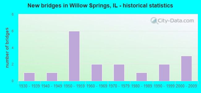
- New bridges - historical statistics
- 11930-1939
- 11940-1949
- 61950-1959
- 21960-1969
- 21970-1979
- 11980-1989
- 21990-1999
- 32000-2009

- Reconstructed bridges - Historical Statistics
- 11970-1979
- 11980-1989
- 11990-1999
- 02000-2009
- 12010-2019


- Bridge Condition - Deck
- 9.1%Good
- 36.4%Satisfactory
- 18.2%Fair
- 18.2%Poor
- 9.1%Serious
- 9.1%Critical

- Bridge Condition - Superstructure
- 8.3%Very good
- 8.3%Good
- 25.0%Satisfactory
- 41.7%Fair
- 8.3%Serious
- 8.3%Critical

- Bridge Condition - Substructure
- 33.3%Good
- 58.3%Satisfactory
- 8.3%Fair

- Bridge Condition - Channel
- 25.0%Very good
- 37.5%Good
- 37.5%Satisfactory
Find on map >> Show street view
Structure Number: 160518, Location: 0.1 M SW US 45 (Lat: 41.745461, Lng: -87.852700), Route carried "on" structure: Other road , Year Built: 1959, Year Reconstructed: 1998, Status: Open, Structure Length: 5.48m (17.98ft), Average Daily Traffic: 22,900 (year 2018), Truck Traffic: 18%, Average Future Daily Traffic: 14,626 (year 2032), Features Intersected: US 12,20,45 MANNHEIM, Facility Carried by Structure: IL 171 & 79 ST EB
Minimum Vertical Clearance: 30+ m (98+ ft), Kilometerpoint: 0.161, Lanes on structure: 2, Lanes under structure: 2, Base Highway Network: Yes (Inventory Route: 20330042, Subroute: 30), Owner: State Highway Agency, Approaching Roadway Width: 9.1m (29.9ft), Skew: 4 degrees, Material/Design: Steel, Design/Construction: Stringer/Multi-beam, Number Of Spans In Main Unit: 3, Length of Maximum Span: 19.8m (65.0ft), Curb-To-Curb Width: 9.1m (29.9ft), Out-to-Out Width: 11.1m (36.4ft)
Condition: Deck: Poor, Superstructure: Fair, Substructure: Fair, Operating Rating: 90.1 metric tons, Method Used To Determine Operating Rating: Load Factor (LF) rating reported by rating factor (RF) method using MS18 loading, Inventory Rating: 45.7 metric tons, Method Used To Determine Inventory Rating: Load Factor (LF) rating reported by rating factor (RF) method using MS18 loading, Structural Evaluation: Somewhat better than minimum adequacy, Deck Geometry: Meets minimum limits, Underclear: High priority of corrective action, Approach Roadway Alignment: Equal to present minimum criteria, Length Of Structure Improvement: 5.49m (18.01ft), Designated Inspection Frequency: Every 24 months, Inspection Date: September 2021, Bridge Improvement Cost: $428,000, Roadway Improvement Cost: $43,000, Total Project Cost: $642,000, Deck Structure Type: Concrete Cast-file-Place, Wearing Surface/Protective System: Wearing Surface: Latex Concrete
Find on map >> Show street view
Structure Number: 16054, Location: 0.1 M N IL 171 (Lat: 41.735206, Lng: -87.881044), Route carried "on" structure: Other road , Year Built: 1976, Year Reconstructed: 2010, Status: Open, Structure Length: 46.63m (152.99ft), Average Daily Traffic: 16,100 (year 2021), Truck Traffic: 6%, Average Future Daily Traffic: 13,287 (year 2032), Design Load: HS 20, Features Intersected: S&S&I&MCANALS,DPL RV, Facility Carried by Structure: WILLOW SPRINGS RD
Minimum Vertical Clearance: 30+ m (98+ ft), Kilometerpoint: 9.479, Lanes on structure: 4, Base Highway Network: Yes, Owner: State Highway Agency, Approaching Roadway Width: 17.7m (58.1ft), Skew: 30 degrees, Navigation Control: Yes ( Vertical Clearance: 11.9m (39.0ft), Horizontal Clearance: 49.7m (163.1ft)), Material/Design: Steel continuous, Design/Construction: Stringer/Multi-beam, Number Of Spans In Main Unit: 9, Length of Maximum Span: 70.3m (230.6ft), Curb or Sidewalk Widths: Left: 1.5m (4.9ft), Right: 0.0m, Curb-To-Curb Width: 17.7m (58.1ft), Out-to-Out Width: 21.3m (69.9ft)
Condition: Deck: Fair, Superstructure: Fair, Substructure: Good, Channel: Good, Operating Rating: 58.6 metric tons, Method Used To Determine Operating Rating: Load Factor (LF) rating reported by rating factor (RF) method using MS18 loading, Inventory Rating: 35.3 metric tons, Method Used To Determine Inventory Rating: Load Factor (LF) rating reported by rating factor (RF) method using MS18 loading, Structural Evaluation: Somewhat better than minimum adequacy, Deck Geometry: Somewhat better than minimum adequacy, Waterway Adequacy: Equal to present desirable criteria, Approach Roadway Alignment: Better than present minimum criteria, Designated Inspection Frequency: Every 24 months, Other Special Inspection Frequency: Every 48 months, Inspection Date: May 2021, Other Special Inspection Date: November 2019, Deck Structure Type: Concrete Cast-file-Place, Wearing Surface/Protective System: Wearing Surface: Latex Concrete
Find on map >> Show street view
Structure Number: 162406, Location: 0.9 M S I-55 (Lat: 41.750628, Lng: -87.858953), Route carried "on" structure: US 12, Year Built: 1980, Status: Open, Structure Length: 40.90m (134.19ft), Average Daily Traffic: 64,200 (year 2021), Truck Traffic: 13%, Average Future Daily Traffic: 38,265 (year 2032), Design Load: HS 20, Features Intersected: RR - CN & CANALS
Minimum Vertical Clearance: 30+ m (98+ ft), Kilometerpoint: 102.947, Lanes on structure: 3, Base Highway Network: Yes, Owner: State Highway Agency, Approaching Roadway Width: 12.2m (40.0ft), Material/Design: Steel continuous, Design/Construction: Stringer/Multi-beam, Number Of Spans In Main Unit: 13, Length of Maximum Span: 88.4m (290.0ft), Curb-To-Curb Width: 12.2m (40.0ft), Out-to-Out Width: 13.2m (43.3ft)
Condition: Deck: Satisfactory, Superstructure: Fair, Substructure: Satisfactory, Channel: Very good, Operating Rating: 38.6 metric tons, Method Used To Determine Operating Rating: Load Factor (LF) rating reported by rating factor (RF) method using MS18 loading, Inventory Rating: 23.3 metric tons, Method Used To Determine Inventory Rating: Load Factor (LF) rating reported by rating factor (RF) method using MS18 loading, Structural Evaluation: Somewhat better than minimum adequacy, Deck Geometry: Meets minimum limits, Underclear: Superior to present desirable criteria, Waterway Adequacy: Equal to present desirable criteria, Approach Roadway Alignment: Better than present minimum criteria, Designated Inspection Frequency: Every 24 months, Underwater Inspection Frequency: Every 60 months, Inspection Date: September 2021, Underwater Inspection Date: July 2021, Deck Structure Type: Concrete Cast-file-Place, Wearing Surface/Protective System: Wearing Surface: Latex Concrete, Deck Protection: Epoxy Coated Reinforcing
Find on map >> Show street view
Structure Number: 162468, Location: 0.9 M S I-55 (Lat: 41.747822, Lng: -87.855728), Route carried "on" structure: US 12, Year Built: 1976, Year Reconstructed: 2022, Status: Open, Structure Length: 40.97m (134.42ft), Average Daily Traffic: 77,700 (year 2019), Truck Traffic: 10%, Average Future Daily Traffic: 38,265 (year 2032), Design Load: HS 20, Features Intersected: S&S & IM CNLS&ICG RR
Minimum Vertical Clearance: 30+ m (98+ ft), Kilometerpoint: 103.349, Lanes on structure: 2, Base Highway Network: Yes, Owner: State Highway Agency, Approaching Roadway Width: 11.6m (38.1ft), Navigation Control: Yes ( Vertical Clearance: 11.9m (39.0ft), Horizontal Clearance: 85.3m (279.9ft)), Material/Design: Steel continuous, Design/Construction: Stringer/Multi-beam, Number Of Spans In Main Unit: 13, Length of Maximum Span: 54.9m (180.1ft), Curb-To-Curb Width: 11.6m (38.1ft), Out-to-Out Width: 12.8m (42.0ft)
Condition: Deck: Poor, Superstructure: Satisfactory, Substructure: Satisfactory, Channel: Very good, Operating Rating: 76.1 metric tons, Method Used To Determine Operating Rating: Load Factor (LF) rating reported by rating factor (RF) method using MS18 loading, Inventory Rating: 40.2 metric tons, Method Used To Determine Inventory Rating: Load Factor (LF) rating reported by rating factor (RF) method using MS18 loading, Structural Evaluation: Equal to present minimum criteria, Deck Geometry: Better than present minimum criteria, Underclear: Superior to present desirable criteria, Waterway Adequacy: Equal to present desirable criteria, Approach Roadway Alignment: Equal to present minimum criteria, Designated Inspection Frequency: Every 24 months, Underwater Inspection Frequency: Every 60 months, Inspection Date: October 2020, Underwater Inspection Date: July 2021, Deck Structure Type: Concrete Cast-file-Place, Wearing Surface/Protective System: Wearing Surface: Other
Find on map >> Show street view
Structure Number: 162646, Location: 2.1 M S I-55 (Lat: 41.733378, Lng: -87.878756), Route carried "on" structure: Other road , Year Built: 1996, Status: Open, Structure Length: 3.22m (10.56ft), Average Daily Traffic: 16,100 (year 2021), Truck Traffic: 6%, Average Future Daily Traffic: 6,644 (year 2032), Design Load: HS 20, Features Intersected: I & M CANAL - OLD, Facility Carried by Structure: WILLOW SPRINGS RD
Minimum Vertical Clearance: 30+ m (98+ ft), Kilometerpoint: 9.833, Lanes on structure: 2, Base Highway Network: Yes, Owner: State Highway Agency, Approaching Roadway Width: 8.8m (28.9ft), Material/Design: Prestressed concrete, Design/Construction: Stringer/Multi-beam, Number Of Spans In Main Unit: 1, Length of Maximum Span: 31.4m (103.0ft), Curb or Sidewalk Widths: Left: 1.5m (4.9ft), Right: 0.0m, Curb-To-Curb Width: 6.7m (22.0ft), Out-to-Out Width: 8.8m (28.9ft)
Condition: Deck: Good, Superstructure: Very good, Substructure: Good, Channel: Satisfactory, Operating Rating: 85.9 metric tons, Method Used To Determine Operating Rating: Load Factor (LF) rating reported by rating factor (RF) method using MS18 loading, Inventory Rating: 44.7 metric tons, Method Used To Determine Inventory Rating: Load Factor (LF) rating reported by rating factor (RF) method using MS18 loading, Structural Evaluation: Better than present minimum criteria, Deck Geometry: High priority of replacement, Waterway Adequacy: Equal to present desirable criteria, Approach Roadway Alignment: Equal to present desirable criteria, Designated Inspection Frequency: Every 24 months, Inspection Date: May 2020, Deck Structure Type: Concrete Cast-file-Place, Wearing Surface/Protective System: Deck Protection: Epoxy Coated Reinforcing
Find on map >> Show street view
Structure Number: 162756, Location: 0.5 M SW I-294 (Lat: 41.743703, Lng: -87.852069), Route carried "on" structure: State highway 171, Year Built: 2003, Status: Open, Structure Length: 6.68m (21.92ft), Average Daily Traffic: 7,600 (year 2019), Truck Traffic: 7%, Average Future Daily Traffic: 21,630 (year 2032), Design Load: HS 20, Features Intersected: US 12,20,45 LAGRANGE
Minimum Vertical Clearance: 30+ m (98+ ft), Kilometerpoint: 32.395, Lanes on structure: 6, Lanes under structure: 7, Base Highway Network: Yes, Owner: State Highway Agency, Approaching Roadway Width: 21.4m (70.2ft), Skew: 2 degrees, Material/Design: Steel continuous, Design/Construction: Stringer/Multi-beam, Number Of Spans In Main Unit: 2, Length of Maximum Span: 32.9m (107.9ft), Curb-To-Curb Width: 27.5m (90.2ft), Out-to-Out Width: 28.4m (93.2ft)
Condition: Deck: Satisfactory, Superstructure: Good, Substructure: Good, Operating Rating: 72.3 metric tons, Method Used To Determine Operating Rating: Load Factor (LF) rating reported by rating factor (RF) method using MS18 loading, Inventory Rating: 43.4 metric tons, Method Used To Determine Inventory Rating: Load Factor (LF) rating reported by rating factor (RF) method using MS18 loading, Structural Evaluation: Better than present minimum criteria, Deck Geometry: Better than present minimum criteria, Underclear: High priority of corrective action, Approach Roadway Alignment: Equal to present desirable criteria, Designated Inspection Frequency: Every 24 months, Inspection Date: September 2021, Deck Structure Type: Concrete Cast-file-Place, Wearing Surface/Protective System: Deck Protection: Epoxy Coated Reinforcing
Find on map >> Show street view
Structure Number: 163017, Location: 0.04 M S 79TH P10 (Lat: 41.744186, Lng: -87.895981), Route carried "on" structure: Other road , Year Built: 1963, Year Reconstructed: 1985, Status: Open, Structure Length: 4.99m (16.37ft), Average Daily Traffic: 2,300 (year 2018), Truck Traffic: 7%, Average Future Daily Traffic: 8,858 (year 2032), Design Load: HS 20, Features Intersected: FLAG CREEK, Facility Carried by Structure: WOLF RD
Minimum Vertical Clearance: 30+ m (98+ ft), Kilometerpoint: 16.222, Lanes on structure: 2, Owner: County Highway Agency, Approaching Roadway Width: 9.1m (29.9ft), Skew: 4 degrees, Material/Design: Prestressed concrete, Design/Construction: Box Beam or Girders - Multiple, Number Of Spans In Main Unit: 3, Length of Maximum Span: 20.7m (67.9ft), Curb or Sidewalk Widths: Left: 1.5m (4.9ft), Right: 1.5m (4.9ft), Curb-To-Curb Width: 8.5m (27.9ft), Out-to-Out Width: 12.2m (40.0ft)
Condition: Deck: Critical, Superstructure: Critical, Substructure: Good, Channel: Satisfactory, Operating Rating: 47.3 metric tons, Method Used To Determine Operating Rating: Load Factor (LF) rating reported by rating factor (RF) method using MS18 loading, Inventory Rating: 23.7 metric tons, Method Used To Determine Inventory Rating: Load Factor (LF) rating reported by rating factor (RF) method using MS18 loading, Structural Evaluation: High priority of replacement, Deck Geometry: Meets minimum limits, Waterway Adequacy: Equal to present minimum criteria, Approach Roadway Alignment: Equal to present desirable criteria, Length Of Structure Improvement: 5.91m (19.39ft), Designated Inspection Frequency: Every 24 months, Inspection Date: December 2021, Bridge Improvement Cost: $684,000, Roadway Improvement Cost: $68,000, Total Project Cost: $1,026,000, Deck Structure Type: Other, Wearing Surface/Protective System: Wearing Surface: Latex Concrete, Membrane: Epoxy
Find on map >> Show street view
Structure Number: 163064, Location: 0.03 M W WOLF P10 (Lat: 41.738875, Lng: -87.896728), Route carried "on" structure: Other road , Year Built: 1963, Status: Open, Structure Length: 3.72m (12.20ft), Average Daily Traffic: 5,700 (year 2018), Truck Traffic: 4%, Average Future Daily Traffic: 4,532 (year 2032), Design Load: HS 20, Features Intersected: FLAG CREEK, Facility Carried by Structure: FAU-1552 GRMN CH R
Minimum Vertical Clearance: 30+ m (98+ ft), Kilometerpoint: 1.529, Lanes on structure: 2, Owner: County Highway Agency, Approaching Roadway Width: 8.5m (27.9ft), Material/Design: Prestressed concrete, Design/Construction: Box Beam or Girders - Multiple, Number Of Spans In Main Unit: 3, Length of Maximum Span: 14.1m (46.3ft), Curb or Sidewalk Widths: Left: 1.5m (4.9ft), Right: 1.5m (4.9ft), Curb-To-Curb Width: 8.5m (27.9ft), Out-to-Out Width: 12.2m (40.0ft)
Condition: Deck: Serious, Superstructure: Serious, Substructure: Satisfactory, Channel: Good, Operating Rating: 75.5 metric tons, Method Used To Determine Operating Rating: Load Factor (LF) rating reported by rating factor (RF) method using MS18 loading, Inventory Rating: 42.8 metric tons, Method Used To Determine Inventory Rating: Load Factor (LF) rating reported by rating factor (RF) method using MS18 loading, Structural Evaluation: High priority of corrective action, Deck Geometry: High priority of replacement, Waterway Adequacy: Equal to present desirable criteria, Approach Roadway Alignment: Equal to present desirable criteria, Length Of Structure Improvement: 4.39m (14.40ft), Designated Inspection Frequency: Every 24 months, Inspection Date: April 2021, Bridge Improvement Cost: $507,000, Roadway Improvement Cost: $51,000, Total Project Cost: $761,000, Deck Structure Type: Concrete Precast Panels, Wearing Surface/Protective System: Wearing Surface: Latex Concrete, Deck Protection: Other
Find on map >> Show street view
Structure Number: 163065, Location: 0.3 M E DUPAGE P10 (Lat: 41.724006, Lng: -87.908036), Route carried "on" structure: Other road , Year Built: 1932, Year Reconstructed: 1981, Status: Open, Structure Length: 2.04m (6.69ft), Average Daily Traffic: 1,350 (year 2018), Truck Traffic: 4%, Average Future Daily Traffic: 1,339 (year 2032), Features Intersected: FLAG CREEK, Facility Carried by Structure: FAU-1560 (91ST ST)
Minimum Vertical Clearance: 30+ m (98+ ft), Kilometerpoint: 0.547, Lanes on structure: 2, Owner: City or Municipal Highway Agency, Approaching Roadway Width: 7.3m (24.0ft), Skew: 3 degrees, Material/Design: Concrete, Design/Construction: Slab, Number Of Spans In Main Unit: 2, Length of Maximum Span: 9.8m (32.2ft), Curb or Sidewalk Widths: Left: 1.5m (4.9ft), Right: 1.5m (4.9ft), Curb-To-Curb Width: 13.4m (44.0ft), Out-to-Out Width: 17.2m (56.4ft)
Condition: Deck: Fair, Superstructure: Fair, Substructure: Satisfactory, Channel: Satisfactory, Operating Rating: 50.5 metric tons, Method Used To Determine Operating Rating: Load Factor (LF) rating reported by rating factor (RF) method using MS18 loading, Inventory Rating: 30.1 metric tons, Method Used To Determine Inventory Rating: Load Factor (LF) rating reported by rating factor (RF) method using MS18 loading, Structural Evaluation: Somewhat better than minimum adequacy, Deck Geometry: Equal to present desirable criteria, Waterway Adequacy: Better than present minimum criteria, Approach Roadway Alignment: Equal to present desirable criteria, Designated Inspection Frequency: Every 24 months, Inspection Date: August 2020, Deck Structure Type: Concrete Cast-file-Place, Wearing Surface/Protective System: Wearing Surface: Integral Concrete, Deck Protection: Epoxy Coated Reinforcing
Find on map >> Show street view
Structure Number: 163093, Location: 0.02 M E WOLF P10 (Lat: 41.746208, Lng: -87.895583), Route carried "on" structure: Other road , Year Built: 1946, Status: Open, Structure Length: 1.39m (4.56ft), Average Daily Traffic: 5,150 (year 2018), Truck Traffic: 4%, Average Future Daily Traffic: 3,863 (year 2032), Design Load: HS 20, Features Intersected: FLAG CREEK, Facility Carried by Structure: 79TH ST
Minimum Vertical Clearance: 30+ m (98+ ft), Kilometerpoint: 1.690, Lanes on structure: 2, Owner: County Highway Agency, Approaching Roadway Width: 12.2m (40.0ft), Skew: 1 degrees, Material/Design: Concrete, Design/Construction: Frame, Number Of Spans In Main Unit: 1, Length of Maximum Span: 13.9m (45.6ft), Curb or Sidewalk Widths: Left: 0.9m (3.0ft), Right: 0.9m (3.0ft), Curb-To-Curb Width: 13.4m (44.0ft), Out-to-Out Width: 16.2m (53.1ft)
Condition: Superstructure: Satisfactory, Substructure: Satisfactory, Channel: Good, Operating Rating: 37.6 metric tons, Method Used To Determine Operating Rating: Load Factor (LF) rating reported by rating factor (RF) method using MS18 loading, Inventory Rating: 22.4 metric tons, Method Used To Determine Inventory Rating: Load Factor (LF) rating reported by rating factor (RF) method using MS18 loading, Structural Evaluation: Somewhat better than minimum adequacy, Deck Geometry: Equal to present minimum criteria, Waterway Adequacy: Better than present minimum criteria, Approach Roadway Alignment: Equal to present desirable criteria, Designated Inspection Frequency: Every 24 months, Inspection Date: June 2021, Deck Structure Type: Concrete Cast-file-Place, Wearing Surface/Protective System: Wearing Surface: Bituminous
Find on map >> Show street view
Structure Number: 169822, Location: 0.6 M NW ILL 171 P10 (Lat: 41.746419, Lng: -87.854647), Route carried "on" structure: Interstate 294, Year Built: 1958, Status: Open, Structure Length: 5.73m (18.80ft), Average Daily Traffic: 64,650 (year 2020), Truck Traffic: 21%, Average Future Daily Traffic: 58,865 (year 2032), Features Intersected: US 12,20-45
Minimum Vertical Clearance: 30+ m (98+ ft), Kilometerpoint: 51.514, Lanes on structure: 4, Lanes under structure: 4, Base Highway Network: Yes, Toll: On toll road, Owner: State Toll Authority, Approaching Roadway Width: 17.7m (58.1ft), Skew: 4 degrees, Material/Design: Steel, Design/Construction: Stringer/Multi-beam, Number Of Spans In Main Unit: 2, Length of Maximum Span: 30.2m (99.1ft), Curb-To-Curb Width: 14.6m (47.9ft), Out-to-Out Width: 22.6m (74.1ft)
Condition: Deck: Satisfactory, Superstructure: Satisfactory, Substructure: Satisfactory, Operating Rating: 75.2 metric tons, Method Used To Determine Operating Rating: Load Factor (LF) rating reported by rating factor (RF) method using MS18 loading, Inventory Rating: 45.4 metric tons, Method Used To Determine Inventory Rating: Load Factor (LF) rating reported by rating factor (RF) method using MS18 loading, Structural Evaluation: Equal to present minimum criteria, Deck Geometry: High priority of replacement, Underclear: Meets minimum limits, Approach Roadway Alignment: Equal to present desirable criteria, Length Of Structure Improvement: 6.89m (22.60ft), Designated Inspection Frequency: Every 24 months, Inspection Date: May 2020, Bridge Improvement Cost: $1,469,000, Roadway Improvement Cost: $147,000, Total Project Cost: $2,204,000, Deck Structure Type: Concrete Cast-file-Place, Wearing Surface/Protective System: Wearing Surface: Bituminous, Membrane: Built-up
Find on map >> Show street view
Structure Number: 169823, Location: 0.6 M NW ILL 171 P10 (Lat: 41.746411, Lng: -87.854450), Route carried "on" structure: Interstate 294, Year Built: 1958, Status: Open, Structure Length: 5.73m (18.80ft), Average Daily Traffic: 64,650 (year 2020), Truck Traffic: 21%, Average Future Daily Traffic: 58,865 (year 2032), Features Intersected: US 12,20-45
Minimum Vertical Clearance: 30+ m (98+ ft), Kilometerpoint: 51.530, Lanes on structure: 4, Lanes under structure: 4, Base Highway Network: Yes, Toll: On toll road, Owner: State Toll Authority, Approaching Roadway Width: 17.7m (58.1ft), Skew: 4 degrees, Material/Design: Steel, Design/Construction: Stringer/Multi-beam, Number Of Spans In Main Unit: 2, Length of Maximum Span: 30.2m (99.1ft), Curb-To-Curb Width: 14.6m (47.9ft), Out-to-Out Width: 22.6m (74.1ft)
Condition: Deck: Satisfactory, Superstructure: Fair, Substructure: Satisfactory, Operating Rating: 71.3 metric tons, Method Used To Determine Operating Rating: Load Factor (LF) rating reported by rating factor (RF) method using MS18 loading, Inventory Rating: 42.8 metric tons, Method Used To Determine Inventory Rating: Load Factor (LF) rating reported by rating factor (RF) method using MS18 loading, Structural Evaluation: Somewhat better than minimum adequacy, Deck Geometry: High priority of replacement, Underclear: Meets minimum limits, Approach Roadway Alignment: Equal to present desirable criteria, Length Of Structure Improvement: 6.89m (22.60ft), Designated Inspection Frequency: Every 24 months, Inspection Date: May 2020, Bridge Improvement Cost: $1,469,000, Roadway Improvement Cost: $147,000, Total Project Cost: $2,204,000, Deck Structure Type: Concrete Cast-file-Place, Wearing Surface/Protective System: Wearing Surface: Bituminous, Membrane: Built-up
Find on map >> Show street view
Structure Number: 160518, Location: 0.1 M SW US 45 (Lat: 41.745272, Lng: -87.853003), Route carried "under" structure: US 12, Year Built: 1959, Structure Length: 0. m, Average Daily Traffic: 43,000 (year 2019), Truck Traffic: 7%, Features Intersected: US 12,20,45 MANNHEIM, Facility Carried by Structure: IL 171 & 79 ST EB
Minimum Vertical Clearance: 4.27m (14.01ft), Kilometerpoint: 103.703, Lanes on structure: 2, Lanes under structure: 2, Material/Design: Steel, Design/Construction: Stringer/Multi-beam, Length of Maximum Span: 19.8m (65.0ft)
Find on map >> Show street view
Structure Number: 162756, Location: 0.5 M SW I-294 (Lat: 41.743653, Lng: -87.852353), Route carried "under" structure: US 12, Year Built: 2003, Structure Length: 0. m, Average Daily Traffic: 43,000 (year 2019), Truck Traffic: 7%, Features Intersected: US 12,20,45 LAGRANGE, Facility Carried by Structure: IL 171 (ARCHER AVE
Minimum Vertical Clearance: 4.80m (15.75ft), Kilometerpoint: 103.896, Lanes on structure: 6, Lanes under structure: 6, Material/Design: Steel continuous, Design/Construction: Stringer/Multi-beam, Length of Maximum Span: 32.9m (107.9ft)
Find on map >> Show street view
Structure Number: 162756, Location: 0.5 M SW I-294 (Lat: 41.743625, Lng: -87.852494), Route carried "under" structure: Other road , Year Built: 2003, Structure Length: 0. m, Average Daily Traffic: 2,450 (year 2018), Truck Traffic: 12%, Features Intersected: US 12,20,45 LAGRANGE, Facility Carried by Structure: IL 171 (ARCHER AVE
Minimum Vertical Clearance: 5.16m (16.93ft), Kilometerpoint: 0.354, Lanes on structure: 6, Lanes under structure: 1, Material/Design: Steel continuous, Design/Construction: Stringer/Multi-beam, Length of Maximum Span: 32.9m (107.9ft)
Find on map >> Show street view
Structure Number: 169822, Location: 0.6 M NW ILL 171 P10 (Lat: 41.746406, Lng: -87.854125), Route carried "under" structure: US 12, Year Built: 1958, Structure Length: 0. m, Average Daily Traffic: 43,000 (year 2019), Truck Traffic: 7%, Features Intersected: US 12,20-45, Facility Carried by Structure: I-294 NB
Minimum Vertical Clearance: 4.55m (14.93ft), Kilometerpoint: 103.510, Lanes on structure: 4, Lanes under structure: 4, Toll: On toll road, Material/Design: Steel, Design/Construction: Stringer/Multi-beam, Length of Maximum Span: 30.2m (99.1ft)
Find on map >> Show street view
Structure Number: 169823, Location: 0.6 M NW ILL 171 P10 (Lat: 41.745936, Lng: -87.853658), Route carried "under" structure: US 12, Year Built: 1958, Structure Length: 0. m, Average Daily Traffic: 43,000 (year 2019), Truck Traffic: 7%, Features Intersected: US 12,20-45, Facility Carried by Structure: I-294 SB
Minimum Vertical Clearance: 4.78m (15.68ft), Kilometerpoint: 103.542, Lanes on structure: 4, Lanes under structure: 4, Toll: On toll road, Material/Design: Steel, Design/Construction: Stringer/Multi-beam, Length of Maximum Span: 30.2m (99.1ft)
Find on map >> Show street view
Structure Number: 169924, Location: .5 N OF IL 171 (Lat: 41.736761, Lng: -87.883050), Route carried "under" structure: Other road , Year Built: 1992, Structure Length: 0. m, Average Daily Traffic: 16,100 (year 2021), Truck Traffic: 6%, Features Intersected: WILLOW SPRINGS RD, Facility Carried by Structure: AT&SF RR
Minimum Vertical Clearance: 4.52m (14.83ft), Kilometerpoint: 9.173, Lanes under structure: 6, Length of Maximum Span: 36.6m (120.1ft)