Bridge Statistics for Willoughby Hills, Ohio (OH)
Condition, Traffic, Stress, Structural Evaluation, Project Costs
- National Bridge Inventory (NBI) Statistics
- 44Number of bridges
- 673ft / 205mTotal length
- $1,600,000Total costs
- 1,165,845Total average daily traffic
- 118,854Total average daily truck traffic
- National Bridge Inventory (NBI) Registered Bridges for Willoughby Hills
- No street view available for this location
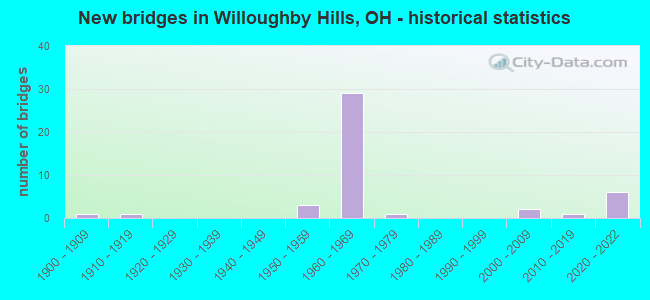
- New bridges - historical statistics
- 11900-1909
- 11910-1919
- 31950-1959
- 291960-1969
- 11970-1979
- 22000-2009
- 12010-2019
- 62020-2022
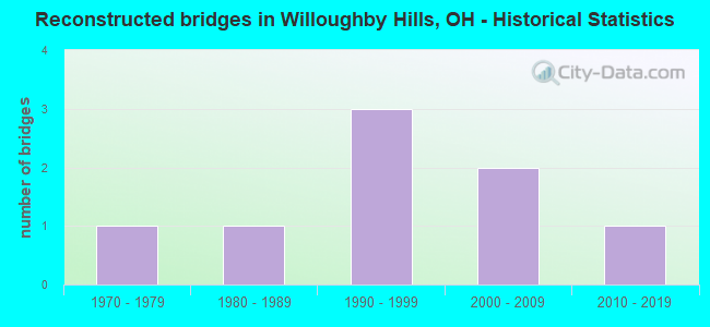
- Reconstructed bridges - Historical Statistics
- 11970-1979
- 11980-1989
- 31990-1999
- 22000-2009
- 12010-2019
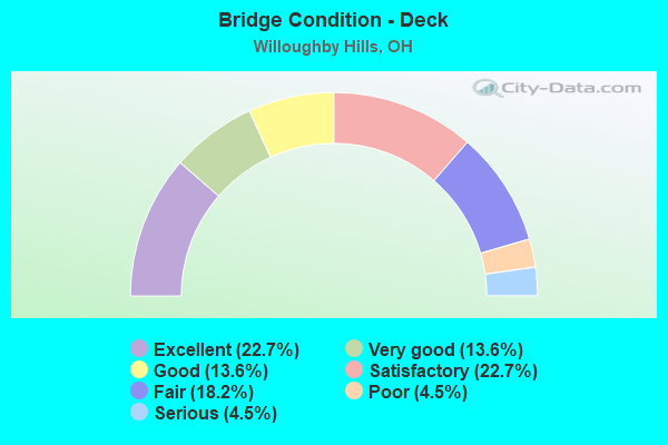
- Bridge Condition - Deck
- 22.7%Excellent
- 13.6%Very good
- 13.6%Good
- 22.7%Satisfactory
- 18.2%Fair
- 4.5%Poor
- 4.5%Serious
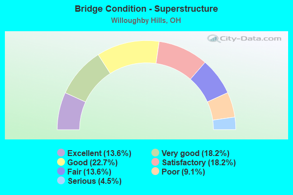
- Bridge Condition - Superstructure
- 13.6%Excellent
- 18.2%Very good
- 22.7%Good
- 18.2%Satisfactory
- 13.6%Fair
- 9.1%Poor
- 4.5%Serious
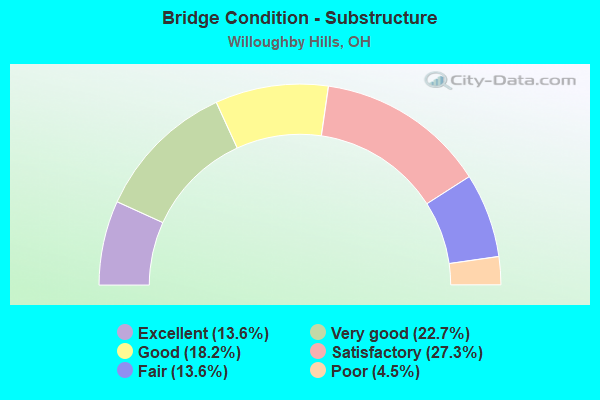
- Bridge Condition - Substructure
- 13.6%Excellent
- 22.7%Very good
- 18.2%Good
- 27.3%Satisfactory
- 13.6%Fair
- 4.5%Poor
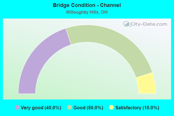
- Bridge Condition - Channel
- 40.0%Very good
- 50.0%Good
- 10.0%Satisfactory
Find on map >> Show street view
Structure Number: 430366, Location: 1.6 MI. N. OF TISCH ROAD (Lat: 41.686239, Lng: -80.815231), Route carried "on" structure: County highway C012L, Year Built: 1955, Status: Open, Structure Length: 1.01m (3.31ft), Average Daily Traffic: 476 (year 2015), Truck Traffic: 8%, Average Future Daily Traffic: 661 (year 2035), Design Load: HS 20, Features Intersected: THREE BROTHERS CREEK, Facility Carried by Structure: FOOTVILLE RICHMOND
Minimum Vertical Clearance: 30+ m (98+ ft), Kilometerpoint: 13.615, Lanes on structure: 2, Owner: County Highway Agency, Approaching Roadway Width: 6.4m (21.0ft), Material/Design: Concrete, Design/Construction: Slab, Number Of Spans In Main Unit: 1, Length of Maximum Span: 9.4m (30.8ft), Curb-To-Curb Width: 8.8m (28.9ft), Out-to-Out Width: 9.1m (29.9ft)
Condition: Deck: Good, Superstructure: Very good, Substructure: Very good, Channel: Very good, Operating Rating: 71.3 metric tons, Method Used To Determine Operating Rating: Load Factor (LF) rating reported by rating factor (RF) method using MS18 loading, Inventory Rating: 42.1 metric tons, Method Used To Determine Inventory Rating: Load Factor (LF) rating reported by rating factor (RF) method using MS18 loading, Structural Evaluation: Equal to present desirable criteria, Deck Geometry: Somewhat better than minimum adequacy, Waterway Adequacy: Better than present minimum criteria, Approach Roadway Alignment: Somewhat better than minimum adequacy, Designated Inspection Frequency: Every 24 months, Inspection Date: April 2021, Deck Structure Type: Concrete Cast-file-Place, Wearing Surface/Protective System: Wearing Surface: Bituminous
Find on map >> Show street view
Structure Number: 430552, Location: .5MI. E. OF SR45 (Lat: 41.781950, Lng: -80.845069), Route carried "on" structure: County highway C016G, Year Built: 1960, Status: Open, Structure Length: 0.85m (2.79ft), Average Daily Traffic: 1,241 (year 2015), Truck Traffic: 7%, Average Future Daily Traffic: 1,723 (year 2035), Design Load: HS 20, Features Intersected: COFFEE CREEK, Facility Carried by Structure: CLAY STREET
Minimum Vertical Clearance: 30+ m (98+ ft), Kilometerpoint: 8.481, Lanes on structure: 2, Owner: County Highway Agency, Approaching Roadway Width: 5.5m (18.0ft), Material/Design: Concrete, Design/Construction: Slab, Number Of Spans In Main Unit: 1, Length of Maximum Span: 7.9m (25.9ft), Curb-To-Curb Width: 9.7m (31.8ft), Out-to-Out Width: 10.1m (33.1ft)
Condition: Deck: Excellent, Superstructure: Very good, Substructure: Very good, Channel: Very good, Operating Rating: 61.6 metric tons, Method Used To Determine Operating Rating: Load Factor (LF) rating reported by rating factor (RF) method using MS18 loading, Inventory Rating: 35.6 metric tons, Method Used To Determine Inventory Rating: Load Factor (LF) rating reported by rating factor (RF) method using MS18 loading, Structural Evaluation: Equal to present desirable criteria, Deck Geometry: Somewhat better than minimum adequacy, Waterway Adequacy: Better than present minimum criteria, Approach Roadway Alignment: Better than present minimum criteria, Designated Inspection Frequency: Every 24 months, Inspection Date: May 2021, Deck Structure Type: Concrete Cast-file-Place, Wearing Surface/Protective System: Wearing Surface: Bituminous
Find on map >> Show street view
Structure Number: 4302044, Location: 1.15 MI E SR174 (Lat: 41.587800, Lng: -81.400881), Route carried "on" structure: US 6, Year Built: 1951, Year Reconstructed: 1984, Status: Open, Structure Length: 11.67m (38.29ft), Average Daily Traffic: 8,595 (year 2015), Truck Traffic: 6%, Average Future Daily Traffic: 11,930 (year 2035), Design Load: H 20, Features Intersected: CHAGRIN RIV .85 MI E 174
Minimum Vertical Clearance: 30+ m (98+ ft), Kilometerpoint: 7.419, Lanes on structure: 2, Owner: State Highway Agency, Approaching Roadway Width: 8.5m (27.9ft), Skew: 3 degrees, Material/Design: Steel continuous, Design/Construction: Stringer/Multi-beam, Number Of Spans In Main Unit: 4, Length of Maximum Span: 32.0m (105.0ft), Curb or Sidewalk Widths: Left: 0.7m (2.3ft), Right: 0.7m (2.3ft), Curb-To-Curb Width: 8.5m (27.9ft), Out-to-Out Width: 10.4m (34.1ft)
Condition: Deck: Satisfactory, Superstructure: Poor, Substructure: Satisfactory, Channel: Good, Operating Rating: 42.1 metric tons, Method Used To Determine Operating Rating: Allowable Stress (AS) rating reported by rating factor (RF) method using MS18 loading, Inventory Rating: 32.4 metric tons, Method Used To Determine Inventory Rating: Allowable Stress (AS) rating reported by rating factor (RF) method using MS18 loading, Structural Evaluation: Meets minimum limits, Deck Geometry: Meets minimum limits, Waterway Adequacy: Superior to present desirable criteria, Approach Roadway Alignment: Equal to present minimum criteria, Length Of Structure Improvement: 8.87m (29.10ft), Designated Inspection Frequency: Every 12 months, Inspection Date: July 2021, Bridge Improvement Cost: $360,000, Roadway Improvement Cost: $36,000, Total Project Cost: $400,000, Deck Structure Type: Concrete Cast-file-Place, Wearing Surface/Protective System: Wearing Surface: Integral Concrete
Find on map >> Show street view
Structure Number: 4303458, Location: .91 MI E OF SR-84 (Lat: 41.590461, Lng: -81.462181), Route carried "on" structure: City street M0709, Year Built: 1963, Year Reconstructed: 2002, Status: Open, Structure Length: 8.41m (27.59ft), Average Daily Traffic: 5,000 (year 2015), Truck Traffic: 5%, Average Future Daily Traffic: 106,905 (year 2035), Design Load: H 15, Features Intersected: I-90, Facility Carried by Structure: ROCKEFELLER DR
Minimum Vertical Clearance: 30+ m (98+ ft), Kilometerpoint: 2.414, Lanes on structure: 2, Lanes under structure: 6, Owner: State Highway Agency, Approaching Roadway Width: 7.3m (24.0ft), Material/Design: Steel continuous, Design/Construction: Stringer/Multi-beam, Number Of Spans In Main Unit: 4, Length of Maximum Span: 25.0m (82.0ft), Curb or Sidewalk Widths: Left: 1.5m (4.9ft), Right: 1.5m (4.9ft), Curb-To-Curb Width: 7.3m (24.0ft), Out-to-Out Width: 11.0m (36.1ft)
Condition: Deck: Good, Superstructure: Good, Substructure: Good, Operating Rating: 42.1 metric tons, Method Used To Determine Operating Rating: Load Factor (LF) rating reported by rating factor (RF) method using MS18 loading, Inventory Rating: 32.4 metric tons, Method Used To Determine Inventory Rating: Load Factor (LF) rating reported by rating factor (RF) method using MS18 loading, Structural Evaluation: Better than present minimum criteria, Deck Geometry: High priority of replacement, Underclear: High priority of corrective action, Approach Roadway Alignment: Equal to present minimum criteria, Length Of Structure Improvement: 8.41m (27.59ft), Designated Inspection Frequency: Every 24 months, Inspection Date: December 2021, Roadway Improvement Cost: $109,000, Total Project Cost: $1,200,000, Deck Structure Type: Concrete Cast-file-Place, Wearing Surface/Protective System: Wearing Surface: Monolithic Concrete, Membrane: Epoxy, Deck Protection: Epoxy Coated Reinforcing
Find on map >> Show street view
Structure Number: 4303482, Location: 1.63 MI E OF SR-84 JCT (Lat: 41.591111, Lng: -81.447889), Route carried "on" structure: Interstate 90, Year Built: 1962, Year Reconstructed: 2010, Status: Open, Structure Length: 18.11m (59.42ft), Average Daily Traffic: 7,372 (year 2015), Truck Traffic: 9%, Average Future Daily Traffic: 10,232 (year 2035), Design Load: HS 20+Mod, Features Intersected: UP 271NB TOGO 90WB,DN 27
Minimum Vertical Clearance: 4.67m (15.32ft), Kilometerpoint: 3.911, Lanes on structure: 2, Lanes under structure: 4, Base Highway Network: Yes, Owner: State Highway Agency, Approaching Roadway Width: 10.4m (34.1ft), Skew: 4 degrees, Material/Design: Steel continuous, Design/Construction: Stringer/Multi-beam, Number Of Spans In Main Unit: 6, Length of Maximum Span: 38.1m (125.0ft), Curb or Sidewalk Widths: Left: 0.7m (2.3ft), Right: 0.7m (2.3ft), Curb-To-Curb Width: 10.7m (35.1ft), Out-to-Out Width: 11.6m (38.1ft)
Condition: Deck: Very good, Superstructure: Satisfactory, Substructure: Satisfactory, Operating Rating: 55.1 metric tons, Method Used To Determine Operating Rating: Load Factor (LF) rating reported by rating factor (RF) method using MS18 loading, Inventory Rating: 32.4 metric tons, Method Used To Determine Inventory Rating: Load Factor (LF) rating reported by rating factor (RF) method using MS18 loading, Structural Evaluation: Equal to present minimum criteria, Deck Geometry: Meets minimum limits, Underclear: High priority of corrective action, Approach Roadway Alignment: Equal to present desirable criteria, Designated Inspection Frequency: Every 12 months, Critical Feature Inspection Frequency: Every 24 months, Inspection Date: December 2021, Critical Feature Inspection Date: October 2020, Deck Structure Type: Concrete Cast-file-Place, Wearing Surface/Protective System: Wearing Surface: Monolithic Concrete
Find on map >> Show street view
Structure Number: 4303571, Location: JCT I 90 & SR 91 (Lat: 41.601639, Lng: -81.439961), Route carried "on" structure: State highway 91, Year Built: 1960, Year Reconstructed: 1992, Status: Open, Structure Length: 19.20m (62.99ft), Average Daily Traffic: 23,051 (year 2015), Truck Traffic: 2%, Average Future Daily Traffic: 31,995 (year 2035), Design Load: HS 20+Mod, Features Intersected: I-90(LAK-90-0328)&I-271X
Minimum Vertical Clearance: 30+ m (98+ ft), Kilometerpoint: 3.428, Lanes on structure: 5, Lanes under structure: 7, Base Highway Network: Yes, Owner: State Highway Agency, Approaching Roadway Width: 22.9m (75.1ft), Skew: 24 degrees, Material/Design: Steel continuous, Design/Construction: Stringer/Multi-beam, Number Of Spans In Main Unit: 6, Length of Maximum Span: 39.6m (129.9ft), Curb-To-Curb Width: 21.3m (69.9ft), Out-to-Out Width: 23.4m (76.8ft)
Condition: Deck: Good, Superstructure: Satisfactory, Substructure: Fair, Operating Rating: 81.0 metric tons, Method Used To Determine Operating Rating: Load Factor (LF) rating reported by rating factor (RF) method using MS18 loading, Inventory Rating: 47.6 metric tons, Method Used To Determine Inventory Rating: Load Factor (LF) rating reported by rating factor (RF) method using MS18 loading, Structural Evaluation: Somewhat better than minimum adequacy, Deck Geometry: Somewhat better than minimum adequacy, Underclear: Meets minimum limits, Approach Roadway Alignment: Equal to present desirable criteria, Designated Inspection Frequency: Every 12 months, Inspection Date: November 2021, Deck Structure Type: Concrete Cast-file-Place
Find on map >> Show street view
Structure Number: 4303636, Location: APPROX 2000FT E SR91 (Lat: 41.605919, Lng: -81.433061), Route carried "on" structure: City street C0708, Year Built: 1963, Year Reconstructed: 2012, Status: Open, Structure Length: 20.04m (65.75ft), Average Daily Traffic: 3,043 (year 2015), Truck Traffic: 5%, Average Future Daily Traffic: 4,224 (year 2035), Design Load: HS 20+Mod, Features Intersected: IR90&271X (LAK-90-3.77), Facility Carried by Structure: MAPLE GROVE RD
Minimum Vertical Clearance: 30+ m (98+ ft), Kilometerpoint: 6.067, Lanes on structure: 2, Lanes under structure: 6, Owner: State Highway Agency, Approaching Roadway Width: 8.5m (27.9ft), Skew: 5 degrees, Material/Design: Steel continuous, Design/Construction: Stringer/Multi-beam, Number Of Spans In Main Unit: 6, Length of Maximum Span: 45.1m (148.0ft), Curb-To-Curb Width: 9.1m (29.9ft), Out-to-Out Width: 10.1m (33.1ft)
Condition: Deck: Excellent, Superstructure: Excellent, Substructure: Very good, Operating Rating: 94.0 metric tons, Method Used To Determine Operating Rating: Load Factor (LF) rating reported by rating factor (RF) method using MS18 loading, Inventory Rating: 58.3 metric tons, Method Used To Determine Inventory Rating: Load Factor (LF) rating reported by rating factor (RF) method using MS18 loading, Structural Evaluation: Equal to present desirable criteria, Deck Geometry: Meets minimum limits, Underclear: Equal to present minimum criteria, Approach Roadway Alignment: Equal to present desirable criteria, Designated Inspection Frequency: Every 24 months, Inspection Date: December 2021, Deck Structure Type: Concrete Cast-file-Place, Wearing Surface/Protective System: Wearing Surface: Monolithic Concrete, Membrane: Epoxy, Deck Protection: Other Coated Reinforcing
Find on map >> Show street view
Structure Number: 430366, Location: I-90SB AND SR-174 JCT (Lat: 41.620669, Lng: -81.409961), Route carried "on" structure: Interstate 90, Year Built: 1961, Status: Open, Structure Length: 5.73m (18.80ft), Average Daily Traffic: 36,138 (year 2015), Truck Traffic: 10%, Average Future Daily Traffic: 50,160 (year 2035), Design Load: HS 20+Mod, Features Intersected: SR 174 (0372) @MP 191.4
Minimum Vertical Clearance: 30+ m (98+ ft), Kilometerpoint: 8.497, Lanes on structure: 3, Lanes under structure: 2, Base Highway Network: Yes, Owner: State Highway Agency, Approaching Roadway Width: 17.1m (56.1ft), Skew: 4 degrees, Material/Design: Steel continuous, Design/Construction: Stringer/Multi-beam, Number Of Spans In Main Unit: 3, Length of Maximum Span: 21.3m (69.9ft), Curb-To-Curb Width: 16.5m (54.1ft), Out-to-Out Width: 17.2m (56.4ft)
Condition: Deck: Satisfactory, Superstructure: Good, Substructure: Good, Operating Rating: 42.1 metric tons, Method Used To Determine Operating Rating: Allowable Stress (AS) rating reported by rating factor (RF) method using MS18 loading, Inventory Rating: 32.4 metric tons, Method Used To Determine Inventory Rating: Allowable Stress (AS) rating reported by rating factor (RF) method using MS18 loading, Structural Evaluation: Better than present minimum criteria, Deck Geometry: Equal to present minimum criteria, Underclear: Meets minimum limits, Approach Roadway Alignment: Equal to present desirable criteria, Designated Inspection Frequency: Every 12 months, Inspection Date: March 2021, Deck Structure Type: Concrete Cast-file-Place, Wearing Surface/Protective System: Wearing Surface: Latex Concrete
Find on map >> Show street view
Structure Number: 4303695, Location: I-90NB AND SR-174 JCT (Lat: 41.619739, Lng: -81.410111), Route carried "on" structure: Interstate 90, Year Built: 1961, Status: Open, Structure Length: 6.58m (21.59ft), Average Daily Traffic: 36,138 (year 2015), Truck Traffic: 10%, Average Future Daily Traffic: 50,160 (year 2035), Design Load: HS 20+Mod, Features Intersected: SR 174 (0370) @MP 191.4
Minimum Vertical Clearance: 30+ m (98+ ft), Kilometerpoint: 8.497, Lanes on structure: 3, Lanes under structure: 2, Base Highway Network: Yes, Owner: State Highway Agency, Approaching Roadway Width: 17.1m (56.1ft), Skew: 5 degrees, Material/Design: Steel continuous, Design/Construction: Stringer/Multi-beam, Number Of Spans In Main Unit: 3, Length of Maximum Span: 24.4m (80.1ft), Curb-To-Curb Width: 16.5m (54.1ft), Out-to-Out Width: 17.2m (56.4ft)
Condition: Deck: Satisfactory, Superstructure: Good, Substructure: Good, Operating Rating: 42.1 metric tons, Method Used To Determine Operating Rating: Allowable Stress (AS) rating reported by rating factor (RF) method using MS18 loading, Inventory Rating: 32.4 metric tons, Method Used To Determine Inventory Rating: Allowable Stress (AS) rating reported by rating factor (RF) method using MS18 loading, Structural Evaluation: Better than present minimum criteria, Deck Geometry: Equal to present minimum criteria, Underclear: Meets minimum limits, Approach Roadway Alignment: Equal to present desirable criteria, Designated Inspection Frequency: Every 12 months, Inspection Date: March 2021, Deck Structure Type: Concrete Cast-file-Place, Wearing Surface/Protective System: Wearing Surface: Low Slump Concrete
Find on map >> Show street view
Structure Number: 4305345, Location: .1 MI N CUY CNTY ON I-271 (Lat: 41.570431, Lng: -81.447950), Route carried "on" structure: County highway 539, Year Built: 1963, Status: Open, Structure Length: 12.25m (40.19ft), Average Daily Traffic: 4,185 (year 2015), Truck Traffic: 5%, Average Future Daily Traffic: 5,809 (year 2035), Design Load: H 15, Features Intersected: IR-271&271X (LAK-271-.01, Facility Carried by Structure: WHITE RD
Minimum Vertical Clearance: 30+ m (98+ ft), Kilometerpoint: 0.354, Lanes on structure: 2, Lanes under structure: 6, Owner: State Highway Agency, Approaching Roadway Width: 10.4m (34.1ft), Skew: 1 degrees, Material/Design: Steel continuous, Design/Construction: Stringer/Multi-beam, Number Of Spans In Main Unit: 6, Length of Maximum Span: 22.6m (74.1ft), Curb or Sidewalk Widths: Left: 0.7m (2.3ft), Right: 0.7m (2.3ft), Curb-To-Curb Width: 7.3m (24.0ft), Out-to-Out Width: 9.4m (30.8ft)
Condition: Deck: Fair, Superstructure: Satisfactory, Substructure: Satisfactory, Operating Rating: 42.1 metric tons, Method Used To Determine Operating Rating: Load Factor (LF) rating reported by rating factor (RF) method using MS18 loading, Inventory Rating: 32.4 metric tons, Method Used To Determine Inventory Rating: Load Factor (LF) rating reported by rating factor (RF) method using MS18 loading, Structural Evaluation: Equal to present minimum criteria, Deck Geometry: High priority of replacement, Underclear: Meets minimum limits, Approach Roadway Alignment: Equal to present desirable criteria, Designated Inspection Frequency: Every 12 months, Inspection Date: October 2021, Deck Structure Type: Concrete Cast-file-Place, Wearing Surface/Protective System: Wearing Surface: Latex Concrete
Find on map >> Show street view
Structure Number: 4305434, Location: LAK-271-1.05 (Lat: 41.585039, Lng: -81.448119), Route carried "on" structure: US 6, Year Built: 1963, Status: Open, Structure Length: 15.00m (49.21ft), Average Daily Traffic: 5,796 (year 2015), Truck Traffic: 2%, Average Future Daily Traffic: 8,045 (year 2035), Design Load: H 20, Features Intersected: IR-271, Facility Carried by Structure: CHARDON RD
Minimum Vertical Clearance: 30+ m (98+ ft), Kilometerpoint: 3.315, Lanes on structure: 2, Lanes under structure: 6, Owner: State Highway Agency, Approaching Roadway Width: 10.7m (35.1ft), Skew: 3 degrees, Material/Design: Steel continuous, Design/Construction: Stringer/Multi-beam, Number Of Spans In Main Unit: 6, Length of Maximum Span: 29.0m (95.1ft), Curb or Sidewalk Widths: Left: 0.7m (2.3ft), Right: 0.7m (2.3ft), Curb-To-Curb Width: 9.1m (29.9ft), Out-to-Out Width: 11.2m (36.7ft)
Condition: Deck: Fair, Superstructure: Good, Substructure: Poor, Operating Rating: 42.1 metric tons, Method Used To Determine Operating Rating: Load Factor (LF) rating reported by rating factor (RF) method using MS18 loading, Inventory Rating: 32.4 metric tons, Method Used To Determine Inventory Rating: Load Factor (LF) rating reported by rating factor (RF) method using MS18 loading, Structural Evaluation: Meets minimum limits, Deck Geometry: Meets minimum limits, Underclear: High priority of corrective action, Approach Roadway Alignment: Equal to present desirable criteria, Designated Inspection Frequency: Every 12 months, Inspection Date: December 2021, Deck Structure Type: Concrete Cast-file-Place, Wearing Surface/Protective System: Wearing Surface: Integral Concrete
Find on map >> Show street view
Structure Number: 4305469, Location: LAK-271-1.27 E (Lat: 41.588431, Lng: -81.446581), Route carried "on" structure: Ramp Interstate 271, Year Built: 1962, Status: Open, Structure Length: 4.36m (14.30ft), Average Daily Traffic: 1,000 (year 1999), Truck Traffic: 10%, Average Future Daily Traffic: 1,388 (year 2019), Design Load: HS 20+Mod, Features Intersected: EDDY ROAD
Minimum Vertical Clearance: 30+ m (98+ ft), Kilometerpoint: 2.044, Lanes on structure: 2, Lanes under structure: 2, Owner: State Highway Agency, Approaching Roadway Width: 10.4m (34.1ft), Skew: 1 degrees, Material/Design: Steel continuous, Design/Construction: Stringer/Multi-beam, Number Of Spans In Main Unit: 3, Length of Maximum Span: 16.2m (53.1ft), Curb-To-Curb Width: 9.1m (29.9ft), Out-to-Out Width: 11.2m (36.7ft)
Condition: Deck: Satisfactory, Superstructure: Fair, Substructure: Good, Operating Rating: 42.1 metric tons, Method Used To Determine Operating Rating: Allowable Stress (AS) rating reported by rating factor (RF) method using MS18 loading, Inventory Rating: 32.4 metric tons, Method Used To Determine Inventory Rating: Allowable Stress (AS) rating reported by rating factor (RF) method using MS18 loading, Structural Evaluation: Somewhat better than minimum adequacy, Deck Geometry: Meets minimum limits, Underclear: Somewhat better than minimum adequacy, Approach Roadway Alignment: Equal to present desirable criteria, Designated Inspection Frequency: Every 12 months, Inspection Date: October 2020, Deck Structure Type: Concrete Cast-file-Place, Wearing Surface/Protective System: Wearing Surface: Integral Concrete
Find on map >> Show street view
Structure Number: 4305493, Location: LAK-271-1.27 (Lat: 41.588389, Lng: -81.449200), Route carried "on" structure: County highway 541, Year Built: 1963, Year Reconstructed: 2021, Status: Open, Structure Length: 15.33m (50.30ft), Average Daily Traffic: 1,212 (year 2015), Truck Traffic: 5%, Average Future Daily Traffic: 1,682 (year 2035), Design Load: H 15, Features Intersected: IR271&271X (LAK-271-0127, Facility Carried by Structure: EDDY RD
Minimum Vertical Clearance: 30+ m (98+ ft), Kilometerpoint: 8.047, Lanes on structure: 2, Lanes under structure: 10, Owner: State Highway Agency, Approaching Roadway Width: 8.5m (27.9ft), Material/Design: Steel continuous, Design/Construction: Stringer/Multi-beam, Number Of Spans In Main Unit: 8, Length of Maximum Span: 21.7m (71.2ft), Curb-To-Curb Width: 8.5m (27.9ft), Out-to-Out Width: 9.5m (31.2ft)
Condition: Deck: Excellent, Superstructure: Very good, Substructure: Excellent, Operating Rating: 42.1 metric tons, Method Used To Determine Operating Rating: Load Factor (LF) rating reported by rating factor (RF) method using MS18 loading, Inventory Rating: 32.4 metric tons, Method Used To Determine Inventory Rating: Load Factor (LF) rating reported by rating factor (RF) method using MS18 loading, Structural Evaluation: Equal to present desirable criteria, Deck Geometry: Somewhat better than minimum adequacy, Underclear: Somewhat better than minimum adequacy, Approach Roadway Alignment: Equal to present desirable criteria, Designated Inspection Frequency: Every 12 months, Inspection Date: December 2021, Deck Structure Type: Concrete Cast-file-Place, Wearing Surface/Protective System: Wearing Surface: Monolithic Concrete
Find on map >> Show street view
Structure Number: 4305494, Location: @ IR-271/IR-90 Interchang (Lat: 41.588161, Lng: -81.446839), Route carried "on" structure: Ramp Interstate 271, Year Built: 2021, Status: Open, Structure Length: 4.54m (14.90ft), Average Daily Traffic: 20,609 (year 2020), Truck Traffic: 3%, Average Future Daily Traffic: 23,700 (year 2040), Design Load: HL 93, Features Intersected: Eddy Rd. (CR-541)
Minimum Vertical Clearance: 30+ m (98+ ft), Kilometerpoint: 2.044, Lanes on structure: 2, Lanes under structure: 2, Owner: State Highway Agency, Approaching Roadway Width: 11.6m (38.1ft), Skew: 1 degrees, Material/Design: Steel, Design/Construction: Stringer/Multi-beam, Number Of Spans In Main Unit: 3, Length of Maximum Span: 16.2m (53.1ft), Curb-To-Curb Width: 11.6m (38.1ft), Out-to-Out Width: 12.6m (41.3ft)
Condition: Deck: Excellent, Superstructure: Excellent, Substructure: Excellent, Operating Rating: 64.8 metric tons, Method Used To Determine Operating Rating: Load and Resistance Factor Rating (LRFR) rating reported by rating factor(RF) method using HL-93 loadings, Inventory Rating: 50.2 metric tons, Method Used To Determine Inventory Rating: Load and Resistance Factor Rating (LRFR) rating reported by rating factor(RF) method using HL-93 loadings, Structural Evaluation: Superior to present desirable criteria, Deck Geometry: Superior to present desirable criteria, Underclear: Superior to present desirable criteria, Approach Roadway Alignment: Superior to present desirable criteria, Designated Inspection Frequency: Every 12 months, Inspection Date: June 2021, Deck Structure Type: Concrete Cast-file-Place, Wearing Surface/Protective System: Wearing Surface: Monolithic Concrete, Membrane: Epoxy, Deck Protection: Epoxy Coated Reinforcing
Find on map >> Show street view
Structure Number: 4305523, Location: 1.67 MI E OF SR-84 JCT (Lat: 41.590789, Lng: -81.447131), Route carried "on" structure: Ramp Interstate 271, Year Built: 1963, Status: Open, Structure Length: 17.77m (58.30ft), Average Daily Traffic: 1,000 (year 1999), Truck Traffic: 10%, Average Future Daily Traffic: 1,388 (year 2019), Design Load: HS 20+Mod, Features Intersected: IR 90 EB (LAK-90-0243R)
Minimum Vertical Clearance: 30+ m (98+ ft), Kilometerpoint: 2.334, Lanes on structure: 2, Lanes under structure: 10, Owner: State Highway Agency, Approaching Roadway Width: 11.3m (37.1ft), Skew: 3 degrees, Material/Design: Steel continuous, Design/Construction: Stringer/Multi-beam, Number Of Spans In Main Unit: 7, Length of Maximum Span: 27.4m (89.9ft), Curb-To-Curb Width: 9.1m (29.9ft), Out-to-Out Width: 11.2m (36.7ft)
Condition: Deck: Poor, Superstructure: Poor, Substructure: Satisfactory, Operating Rating: 42.1 metric tons, Method Used To Determine Operating Rating: Allowable Stress (AS) rating reported by rating factor (RF) method using MS18 loading, Inventory Rating: 32.4 metric tons, Method Used To Determine Inventory Rating: Allowable Stress (AS) rating reported by rating factor (RF) method using MS18 loading, Structural Evaluation: Meets minimum limits, Deck Geometry: Meets minimum limits, Underclear: High priority of corrective action, Approach Roadway Alignment: Equal to present desirable criteria, Designated Inspection Frequency: Every 12 months, Inspection Date: July 2020, Deck Structure Type: Concrete Cast-file-Place, Wearing Surface/Protective System: Wearing Surface: Low Slump Concrete
Find on map >> Show street view
Structure Number: 4305524, Location: @ IR-271/IR-90 Interchang (Lat: 41.590131, Lng: -81.446811), Route carried "on" structure: Ramp Interstate 271, Year Built: 2021, Status: Open, Structure Length: 19.37m (63.55ft), Average Daily Traffic: 20,609 (year 2020), Truck Traffic: 3%, Average Future Daily Traffic: 23,700 (year 2040), Design Load: HL 93, Features Intersected: IR-271, IR-271X, IR-90EB
Minimum Vertical Clearance: 30+ m (98+ ft), Kilometerpoint: 2.334, Lanes on structure: 2, Lanes under structure: 10, Owner: State Highway Agency, Approaching Roadway Width: 15.2m (49.9ft), Skew: 9 degrees, Material/Design: Steel, Design/Construction: Stringer/Multi-beam, Number Of Spans In Main Unit: 4, Length of Maximum Span: 60.0m (196.9ft), Curb-To-Curb Width: 15.2m (49.9ft), Out-to-Out Width: 17.5m (57.4ft)
Condition: Deck: Excellent, Superstructure: Excellent, Substructure: Excellent, Operating Rating: 42.8 metric tons, Method Used To Determine Operating Rating: Load and Resistance Factor Rating (LRFR) rating reported by rating factor(RF) method using HL-93 loadings, Inventory Rating: 33.0 metric tons, Method Used To Determine Inventory Rating: Load and Resistance Factor Rating (LRFR) rating reported by rating factor(RF) method using HL-93 loadings, Structural Evaluation: Superior to present desirable criteria, Deck Geometry: Superior to present desirable criteria, Underclear: High priority of corrective action, Approach Roadway Alignment: Superior to present desirable criteria, Designated Inspection Frequency: Every 12 months, Inspection Date: June 2021, Deck Structure Type: Concrete Cast-file-Place, Wearing Surface/Protective System: Wearing Surface: Monolithic Concrete, Membrane: Epoxy, Deck Protection: Epoxy Coated Reinforcing
Find on map >> Show street view
Structure Number: 4351576, Location: 0.59 MI. N/ CUYAHOGA CTY. (Lat: 41.578731, Lng: -81.478500), Route carried "on" structure: County highway C0711, Year Built: 1978, Status: Posted for load, Structure Length: 1.07m (3.51ft), Average Daily Traffic: 9,626 (year 2015), Truck Traffic: 7%, Average Future Daily Traffic: 13,361 (year 2035), Design Load: HS 20+Mod, Features Intersected: STREAM, Facility Carried by Structure: BISHOP ROAD
Minimum Vertical Clearance: 30+ m (98+ ft), Kilometerpoint: 0.950, Lanes on structure: 2, Owner: County Highway Agency, Approaching Roadway Width: 7.3m (24.0ft), Material/Design: Concrete, Design/Construction: Slab, Number Of Spans In Main Unit: 1, Length of Maximum Span: 9.4m (30.8ft), Curb or Sidewalk Widths: Left: 1.5m (4.9ft), Right: 1.5m (4.9ft), Curb-To-Curb Width: 15.9m (52.2ft), Out-to-Out Width: 18.9m (62.0ft)
Condition: Deck: Serious, Superstructure: Serious, Substructure: Satisfactory, Channel: Satisfactory, Operating Rating: 19.4 metric tons, Method Used To Determine Operating Rating: Load Factor (LF) rating reported by rating factor (RF) method using MS18 loading, Inventory Rating: 13.0 metric tons, Method Used To Determine Inventory Rating: Load Factor (LF) rating reported by rating factor (RF) method using MS18 loading, Structural Evaluation: High priority of corrective action, Deck Geometry: Superior to present desirable criteria, Waterway Adequacy: Equal to present desirable criteria, Approach Roadway Alignment: Equal to present desirable criteria, Bridge Posting: Required (Relationship of Operating Rating to Maximum Legal Load: > 39.9% below), Designated Inspection Frequency: Every 12 months, Inspection Date: November 2021, Deck Structure Type: Concrete Cast-file-Place, Wearing Surface/Protective System: Wearing Surface: Bituminous
Find on map >> Show street view
Structure Number: 4351819, Location: 0.64 MI. N/ PLEASANT VALY (Lat: 41.592219, Lng: -81.395000), Route carried "on" structure: City street 703, Year Built: 2011, Status: Open, Structure Length: 4.57m (14.99ft), Average Daily Traffic: 415 (year 2009), Average Future Daily Traffic: 576 (year 2029), Design Load: HS 20+Mod, Features Intersected: CHAGRIN RIVER, Facility Carried by Structure: DODD ROAD
Minimum Vertical Clearance: 30+ m (98+ ft), Kilometerpoint: 1.030, Lanes on structure: 2, Owner: County Highway Agency, Approaching Roadway Width: 6.7m (22.0ft), Material/Design: Prestressed concrete continuous, Design/Construction: Stringer/Multi-beam, Number Of Spans In Main Unit: 3, Length of Maximum Span: 16.8m (55.1ft), Curb-To-Curb Width: 8.5m (27.9ft), Out-to-Out Width: 8.5m (27.9ft)
Condition: Deck: Very good, Superstructure: Very good, Substructure: Very good, Channel: Very good, Operating Rating: 55.1 metric tons, Method Used To Determine Operating Rating: Load Factor (LF) rating reported by rating factor (RF) method using MS18 loading, Inventory Rating: 32.4 metric tons, Method Used To Determine Inventory Rating: Load Factor (LF) rating reported by rating factor (RF) method using MS18 loading, Structural Evaluation: Equal to present desirable criteria, Deck Geometry: High priority of corrective action, Waterway Adequacy: Superior to present desirable criteria, Approach Roadway Alignment: Better than present minimum criteria, Designated Inspection Frequency: Every 24 months, Inspection Date: December 2021, Deck Structure Type: Other, Wearing Surface/Protective System: Wearing Surface: Bituminous, Membrane: Preformed Fabric, Deck Protection: Other
Find on map >> Show street view
Structure Number: 4351843, Location: 0.72 MI. E/ S.R.174 (Lat: 41.603289, Lng: -81.405219), Route carried "on" structure: City street 710, Year Built: 1952, Year Reconstructed: 2004, Status: Open, Structure Length: 4.63m (15.19ft), Average Daily Traffic: 2,223 (year 2015), Truck Traffic: 5%, Average Future Daily Traffic: 3,086 (year 2035), Design Load: HS 20, Features Intersected: CHAGRIN RIVER, Facility Carried by Structure: EAGLE ROAD
Minimum Vertical Clearance: 30+ m (98+ ft), Kilometerpoint: 1.159, Lanes on structure: 2, Owner: County Highway Agency, Approaching Roadway Width: 6.4m (21.0ft), Material/Design: Steel, Design/Construction: Truss - Thru, Number Of Spans In Main Unit: 2, Length of Maximum Span: 21.9m (71.9ft), Curb-To-Curb Width: 6.6m (21.7ft), Out-to-Out Width: 7.3m (24.0ft)
Condition: Deck: Fair, Superstructure: Satisfactory, Substructure: Satisfactory, Channel: Good, Operating Rating: 38.9 metric tons, Method Used To Determine Operating Rating: Load Factor (LF) rating reported by rating factor (RF) method using MS18 loading, Inventory Rating: 22.7 metric tons, Method Used To Determine Inventory Rating: Load Factor (LF) rating reported by rating factor (RF) method using MS18 loading, Structural Evaluation: Equal to present minimum criteria, Deck Geometry: High priority of replacement, Waterway Adequacy: Superior to present desirable criteria, Approach Roadway Alignment: Superior to present desirable criteria, Designated Inspection Frequency: Every 12 months, Critical Feature Inspection Frequency: Every 24 months, Inspection Date: December 2021, Critical Feature Inspection Date: September 2020, Deck Structure Type: Wood or Timber, Wearing Surface/Protective System: Wearing Surface: Bituminous
Find on map >> Show street view
Structure Number: 4352343, Location: 0.23 MI E. OF SR 174 (Lat: 41.569781, Lng: -81.413161), Route carried "on" structure: City street 702, Year Built: 2002, Status: Open, Structure Length: 7.68m (25.20ft), Average Daily Traffic: 1,000 (year 2002), Truck Traffic: 2%, Average Future Daily Traffic: 1,388 (year 2022), Design Load: HS 20+Mod, Features Intersected: CHAGRIN RIVER, Facility Carried by Structure: ROGERS ROAD
Minimum Vertical Clearance: 30+ m (98+ ft), Kilometerpoint: 0.370, Lanes on structure: 2, Owner: County Highway Agency, Approaching Roadway Width: 6.1m (20.0ft), Skew: 3 degrees, Material/Design: Steel continuous, Design/Construction: Stringer/Multi-beam, Number Of Spans In Main Unit: 2, Length of Maximum Span: 38.1m (125.0ft), Curb-To-Curb Width: 8.5m (27.9ft), Out-to-Out Width: 8.9m (29.2ft)
Condition: Deck: Very good, Superstructure: Good, Substructure: Very good, Channel: Very good, Operating Rating: 94.0 metric tons, Method Used To Determine Operating Rating: Load Factor (LF) rating reported by rating factor (RF) method using MS18 loading, Inventory Rating: 55.1 metric tons, Method Used To Determine Inventory Rating: Load Factor (LF) rating reported by rating factor (RF) method using MS18 loading, Structural Evaluation: Better than present minimum criteria, Deck Geometry: Somewhat better than minimum adequacy, Waterway Adequacy: Equal to present desirable criteria, Approach Roadway Alignment: Equal to present minimum criteria, Designated Inspection Frequency: Every 24 months, Inspection Date: December 2021, Deck Structure Type: Concrete Cast-file-Place, Wearing Surface/Protective System: Wearing Surface: Bituminous, Membrane: Preformed Fabric, Deck Protection: Epoxy Coated Reinforcing
Find on map >> Show street view
Structure Number: 4352491, Location: 0.40 MI. E/ OAKVIEW DR. (Lat: 41.574339, Lng: -81.480961), Route carried "on" structure: City street 266, Year Built: 1918, Year Reconstructed: 1998, Status: Open, Structure Length: 0.70m (2.30ft), Average Daily Traffic: 4,185 (year 2015), Truck Traffic: 5%, Average Future Daily Traffic: 5,809 (year 2035), Design Load: HS 20+Mod, Features Intersected: STREAM, Facility Carried by Structure: WHITE ROAD
Minimum Vertical Clearance: 30+ m (98+ ft), Kilometerpoint: 0.644, Lanes on structure: 2, Owner: County Highway Agency, Approaching Roadway Width: 6.4m (21.0ft), Material/Design: Concrete, Design/Construction: Slab, Number Of Spans In Main Unit: 1, Length of Maximum Span: 6.1m (20.0ft), Curb or Sidewalk Widths: Left: 0.0m, Right: 1.5m (4.9ft), Curb-To-Curb Width: 6.7m (22.0ft), Out-to-Out Width: 7.0m (23.0ft)
Condition: Deck: Fair, Superstructure: Fair, Substructure: Fair, Channel: Good, Operating Rating: 87.5 metric tons, Method Used To Determine Operating Rating: Load Factor (LF) rating reported by rating factor (RF) method using MS18 loading, Inventory Rating: 51.8 metric tons, Method Used To Determine Inventory Rating: Load Factor (LF) rating reported by rating factor (RF) method using MS18 loading, Structural Evaluation: Somewhat better than minimum adequacy, Deck Geometry: High priority of replacement, Waterway Adequacy: Equal to present desirable criteria, Approach Roadway Alignment: Equal to present desirable criteria, Designated Inspection Frequency: Every 12 months, Inspection Date: November 2021, Deck Structure Type: Concrete Cast-file-Place, Wearing Surface/Protective System: Wearing Surface: Bituminous, Membrane: Preformed Fabric, Deck Protection: Epoxy Coated Reinforcing
Find on map >> Show street view
Structure Number: 4352564, Location: 0.71 MILES N OF GEAUGA CO (Lat: 41.579669, Lng: -81.391339), Route carried "on" structure: City street 70, Year Built: 2007, Status: Open, Structure Length: 0.91m (2.99ft), Average Daily Traffic: 1,218 (year 2006), Truck Traffic: 3%, Average Future Daily Traffic: 1,691 (year 2026), Design Load: HS 20+Mod, Features Intersected: CAVES CREEK, Facility Carried by Structure: WORRELL ROAD
Minimum Vertical Clearance: 30+ m (98+ ft), Kilometerpoint: 1.143, Lanes on structure: 2, Owner: County Highway Agency, Approaching Roadway Width: 7.9m (25.9ft), Material/Design: Concrete, Design/Construction: Culvert, Number Of Spans In Main Unit: 1, Length of Maximum Span: 8.5m (27.9ft)
Condition: Channel: Good, Culverts: Good, Operating Rating: 68.0 metric tons, Method Used To Determine Operating Rating: Load Factor (LF) rating reported by rating factor (RF) method using MS18 loading, Inventory Rating: 48.6 metric tons, Method Used To Determine Inventory Rating: Load Factor (LF) rating reported by rating factor (RF) method using MS18 loading, Structural Evaluation: Better than present minimum criteria, Waterway Adequacy: Superior to present desirable criteria, Approach Roadway Alignment: Equal to present desirable criteria, Designated Inspection Frequency: Every 24 months, Inspection Date: December 2021
Find on map >> Show street view
Structure Number: 4370554, Location: INTERSECTION OF DODD RD (Lat: 41.589600, Lng: -81.402561), Route carried "on" structure: City street 85, Year Built: 1900, Year Reconstructed: 2005, Status: Posted for load, Structure Length: 5.09m (16.70ft), Average Daily Traffic: 480 (year 1995), Truck Traffic: 5%, Average Future Daily Traffic: 666 (year 2015), Design Load: HS 20, Features Intersected: CHAGRIN RIVER, Facility Carried by Structure: PLEASANT VALLEY RD
Minimum Vertical Clearance: 5.64m (18.50ft), Kilometerpoint: 0.805, Lanes on structure: 1, Owner: City or Municipal Highway Agency, Approaching Roadway Width: 5.5m (18.0ft), Material/Design: Steel, Design/Construction: Truss - Thru, Number Of Spans In Main Unit: 1, Length of Maximum Span: 49.7m (163.1ft), Curb-To-Curb Width: 4.7m (15.4ft), Out-to-Out Width: 4.7m (15.4ft)
Condition: Deck: Satisfactory, Superstructure: Fair, Substructure: Fair, Channel: Good, Operating Rating: 19.4 metric tons, Method Used To Determine Operating Rating: Load Factor (LF) rating reported by rating factor (RF) method using MS18 loading, Inventory Rating: 9.7 metric tons, Method Used To Determine Inventory Rating: Load Factor (LF) rating reported by rating factor (RF) method using MS18 loading, Structural Evaluation: High priority of corrective action, Deck Geometry: High priority of replacement, Waterway Adequacy: Equal to present desirable criteria, Approach Roadway Alignment: Equal to present minimum criteria, Bridge Posting: Required (Relationship of Operating Rating to Maximum Legal Load: > 39.9% below), Designated Inspection Frequency: Every 12 months, Critical Feature Inspection Frequency: Every 24 months, Inspection Date: May 2021, Critical Feature Inspection Date: May 2021, Deck Structure Type: Wood or Timber, Wearing Surface/Protective System: Wearing Surface: Bituminous
Find on map >> Show street view
Structure Number: 4303458, Location: .91 MI E OF SR-84 (Lat: 41.590461, Lng: -81.462181), Route carried "under" structure: Interstate 90, Year Built: 1963, Structure Length: 0. m, Average Daily Traffic: 77,021 (year 2015), Truck Traffic: 5%, Features Intersected: ROCKEFELLER DRIVE, Facility Carried by Structure: ROCKEFELLER DR
Minimum Vertical Clearance: 4.98m (16.34ft), Kilometerpoint: 2.752, Lanes on structure: 2, Lanes under structure: 6, Material/Design: Steel continuous, Design/Construction: Stringer/Multi-beam, Length of Maximum Span: 25.0m (82.0ft)
Find on map >> Show street view
Structure Number: 4303482, Location: 1.63 MI E OF SR-84 JCT (Lat: 41.591111, Lng: -81.447889), Route carried "under" structure: Interstate 271, Year Built: 1962, Structure Length: 0. m, Average Daily Traffic: 55,006 (year 2015), Truck Traffic: 14%, Features Intersected: IR 90 EB
Minimum Vertical Clearance: 5.00m (16.40ft), Kilometerpoint: 2.398, Lanes on structure: 2, Lanes under structure: 4, Material/Design: Steel continuous, Design/Construction: Stringer/Multi-beam, Length of Maximum Span: 38.1m (125.0ft)
Find on map >> Show street view
Structure Number: 4303482, Location: 1.63 MI E OF SR-84 JCT (Lat: 41.591111, Lng: -81.447889), Route carried "under" structure: Interstate 271X, Year Built: 1962, Structure Length: 0. m, Features Intersected: IR 90 EB, Facility Carried by Structure: I-90EB OVER I-271
Minimum Vertical Clearance: 5.08m (16.67ft), Kilometerpoint: 2.398, Lanes on structure: 2, Lanes under structure: 4, Material/Design: Steel continuous, Design/Construction: Stringer/Multi-beam, Length of Maximum Span: 38.1m (125.0ft)
Find on map >> Show street view
Structure Number: 4303571, Location: JCT I 90 & SR 91 (Lat: 41.601639, Lng: -81.439961), Route carried "under" structure: Interstate 90, Year Built: 1960, Structure Length: 0. m, Average Daily Traffic: 86,530 (year 2015), Truck Traffic: 10%, Features Intersected: SR 91 (0213)SOM CENTER R, Facility Carried by Structure: SR 91
Minimum Vertical Clearance: 4.97m (16.31ft), Kilometerpoint: 5.279, Lanes on structure: 5, Lanes under structure: 7, Material/Design: Steel continuous, Design/Construction: Stringer/Multi-beam, Length of Maximum Span: 39.6m (129.9ft)
Find on map >> Show street view
Structure Number: 4303571, Location: JCT I 90 & SR 91 (Lat: 41.601639, Lng: -81.439961), Route carried "under" structure: Interstate 271X, Year Built: 1960, Structure Length: 0. m, Features Intersected: SR 91 (0213)SOM CENTER R, Facility Carried by Structure: SR 91
Minimum Vertical Clearance: 3.05m (10.01ft), Kilometerpoint: 5.279, Lanes on structure: 5, Lanes under structure: 7, Material/Design: Steel continuous, Design/Construction: Stringer/Multi-beam, Length of Maximum Span: 39.6m (129.9ft)
Find on map >> Show street view
Structure Number: 4303636, Location: APPROX 2000FT E SR91 (Lat: 41.605919, Lng: -81.433061), Route carried "under" structure: Interstate 90, Year Built: 1963, Structure Length: 0. m, Average Daily Traffic: 72,275 (year 2015), Truck Traffic: 10%, Features Intersected: Maple Grove Rd., Facility Carried by Structure: MAPLE GROVE RD
Minimum Vertical Clearance: 5.36m (17.59ft), Kilometerpoint: 6.067, Lanes on structure: 2, Lanes under structure: 6, Material/Design: Steel continuous, Design/Construction: Stringer/Multi-beam, Length of Maximum Span: 45.1m (148.0ft)
Find on map >> Show street view
Structure Number: 4303636, Location: APPROX 2000FT E SR91 (Lat: 41.605919, Lng: -81.433061), Route carried "under" structure: Interstate 271X, Year Built: 1963, Structure Length: 0. m, Average Daily Traffic: 74,530 (year 2011), Truck Traffic: 13%, Features Intersected: Maple Grove Rd., Facility Carried by Structure: MAPLE GROVE RD
Minimum Vertical Clearance: 6.78m (22.24ft), Kilometerpoint: 4.442, Lanes on structure: 2, Lanes under structure: 6, Material/Design: Steel continuous, Design/Construction: Stringer/Multi-beam, Length of Maximum Span: 45.1m (148.0ft)
Find on map >> Show street view
Structure Number: 430366, Location: I-90SB AND SR-174 JCT (Lat: 41.620669, Lng: -81.409961), Route carried "under" structure: State highway 174, Year Built: 1961, Structure Length: 0. m, Average Daily Traffic: 5,354 (year 2015), Truck Traffic: 2%, Features Intersected: I-90 (LAK-90-0528L)
Minimum Vertical Clearance: 5.23m (17.16ft), Kilometerpoint: 5.987, Lanes on structure: 3, Lanes under structure: 2, Material/Design: Steel continuous, Design/Construction: Stringer/Multi-beam, Length of Maximum Span: 21.3m (69.9ft)
Find on map >> Show street view
Structure Number: 4303695, Location: I-90NB AND SR-174 JCT (Lat: 41.619739, Lng: -81.410111), Route carried "under" structure: State highway 174, Year Built: 1961, Structure Length: 0. m, Average Daily Traffic: 5,354 (year 2015), Truck Traffic: 2%, Features Intersected: I-90 (LAK-90-0528R)
Minimum Vertical Clearance: 4.55m (14.93ft), Kilometerpoint: 5.955, Lanes on structure: 3, Lanes under structure: 2, Material/Design: Steel continuous, Design/Construction: Stringer/Multi-beam, Length of Maximum Span: 24.4m (80.1ft)
Find on map >> Show street view
Structure Number: 4305345, Location: .1 MI N CUY CNTY ON I-271 (Lat: 41.570431, Lng: -81.447950), Route carried "under" structure: Interstate 271, Year Built: 1963, Structure Length: 0. m, Average Daily Traffic: 106,347 (year 2015), Truck Traffic: 14%, Features Intersected: CR-266 (White Rd.), Facility Carried by Structure: WHITE RD
Minimum Vertical Clearance: 4.96m (16.27ft), Kilometerpoint: 0.016, Lanes on structure: 2, Lanes under structure: 6, Material/Design: Steel continuous, Design/Construction: Stringer/Multi-beam, Length of Maximum Span: 22.6m (74.1ft)
Find on map >> Show street view
Structure Number: 4305345, Location: .1 MI N CUY CNTY ON I-271 (Lat: 41.570431, Lng: -81.447950), Route carried "under" structure: Interstate 271X, Year Built: 1963, Structure Length: 0. m, Average Daily Traffic: 103,880 (year 2011), Truck Traffic: 9%, Features Intersected: CR-266 (White Rd.), Facility Carried by Structure: WHITE RD
Minimum Vertical Clearance: 6.78m (22.24ft), Kilometerpoint: 0.016, Lanes on structure: 2, Lanes under structure: 6, Material/Design: Steel continuous, Design/Construction: Stringer/Multi-beam, Length of Maximum Span: 22.6m (74.1ft)
Find on map >> Show street view
Structure Number: 4305434, Location: LAK-271-1.05 (Lat: 41.585039, Lng: -81.448119), Route carried "under" structure: Interstate 271, Year Built: 1963, Structure Length: 0. m, Average Daily Traffic: 106,347 (year 2015), Truck Traffic: 14%, Features Intersected: US-6 (LAK-6-0206), Facility Carried by Structure: CHARDON RD
Minimum Vertical Clearance: 4.83m (15.85ft), Kilometerpoint: 1.690, Lanes on structure: 2, Lanes under structure: 6, Material/Design: Steel continuous, Design/Construction: Stringer/Multi-beam, Length of Maximum Span: 29.0m (95.1ft)
Find on map >> Show street view
Structure Number: 4305434, Location: LAK-271-1.05 (Lat: 41.585039, Lng: -81.448119), Route carried "under" structure: Interstate 271X, Year Built: 1963, Structure Length: 0. m, Features Intersected: US-6 (LAK-6-0206), Facility Carried by Structure: CHARDON RD
Minimum Vertical Clearance: 4.90m (16.08ft), Kilometerpoint: 1.690, Lanes on structure: 2, Lanes under structure: 6, Material/Design: Steel continuous, Design/Construction: Stringer/Multi-beam, Length of Maximum Span: 29.0m (95.1ft)
Find on map >> Show street view
Structure Number: 4305469, Location: LAK-271-1.27 E (Lat: 41.588431, Lng: -81.446581), Route carried "under" structure: City street 704, Year Built: 1962, Structure Length: 0. m, Average Daily Traffic: 1,212 (year 2015), Truck Traffic: 5%, Features Intersected: IR 271 NB TOGO IR 90 EB, Facility Carried by Structure: I-271-EDY RD.RMP.C
Minimum Vertical Clearance: 4.40m (14.44ft), Kilometerpoint: 26.554, Lanes on structure: 2, Lanes under structure: 2, Material/Design: Steel continuous, Design/Construction: Stringer/Multi-beam, Length of Maximum Span: 16.2m (53.1ft)
Find on map >> Show street view
Structure Number: 4305493, Location: LAK-271-1.27 (Lat: 41.588389, Lng: -81.449200), Route carried "under" structure: Interstate 271, Year Built: 1963, Structure Length: 0. m, Average Daily Traffic: 55,006 (year 2015), Truck Traffic: 14%, Features Intersected: 00271, Facility Carried by Structure: EDDY RD
Minimum Vertical Clearance: 5.11m (16.77ft), Kilometerpoint: 2.044, Lanes on structure: 2, Lanes under structure: 10, Material/Design: Steel continuous, Design/Construction: Stringer/Multi-beam, Length of Maximum Span: 21.7m (71.2ft)
Find on map >> Show street view
Structure Number: 4305493, Location: LAK-271-1.27 (Lat: 41.588389, Lng: -81.449200), Route carried "under" structure: Interstate 271X, Year Built: 1963, Structure Length: 0. m, Average Daily Traffic: 103,880 (year 2011), Truck Traffic: 9%, Features Intersected: Eddy Rd, Facility Carried by Structure: EDDY RD
Minimum Vertical Clearance: 5.36m (17.59ft), Kilometerpoint: 2.044, Lanes on structure: 2, Lanes under structure: 10, Material/Design: Steel continuous, Design/Construction: Stringer/Multi-beam, Length of Maximum Span: 21.7m (71.2ft)
Find on map >> Show street view
Structure Number: 4305494, Location: @ IR-271/IR-90 Interchang (Lat: 41.588161, Lng: -81.446839), Route carried "under" structure: County highway C0541, Year Built: 2021, Structure Length: 0. m, Average Daily Traffic: 1,456 (year 2020), Truck Traffic: 4%, Features Intersected: IR271NB to go IR90EB, Facility Carried by Structure: Eddy Rd. (cr-541)
Minimum Vertical Clearance: 5.04m (16.54ft), Kilometerpoint: 2.765, Lanes on structure: 2, Lanes under structure: 2, Material/Design: Steel, Design/Construction: Stringer/Multi-beam, Length of Maximum Span: 16.2m (53.1ft)
Find on map >> Show street view
Structure Number: 4305523, Location: 1.67 MI E OF SR-84 JCT (Lat: 41.590789, Lng: -81.447131), Route carried "under" structure: Interstate 90, Year Built: 1963, Structure Length: 0. m, Average Daily Traffic: 14,744 (year 2015), Truck Traffic: 9%, Features Intersected: I-271 & LAK-271-0145SW
Minimum Vertical Clearance: 5.06m (16.60ft), Kilometerpoint: 3.975, Lanes on structure: 2, Lanes under structure: 10, Material/Design: Steel continuous, Design/Construction: Stringer/Multi-beam, Length of Maximum Span: 27.4m (89.9ft)
Find on map >> Show street view
Structure Number: 4305524, Location: @ IR-271/IR-90 Interchang (Lat: 41.590131, Lng: -81.446811), Route carried "under" structure: Interstate 271X, Year Built: 2021, Structure Length: 0. m, Features Intersected: IR271NB to go IR90EB
Minimum Vertical Clearance: 16.15m (52.99ft), Kilometerpoint: 2.308, Lanes on structure: 2, Lanes under structure: 10, Material/Design: Steel, Design/Construction: Stringer/Multi-beam, Length of Maximum Span: 60.0m (196.9ft)
Find on map >> Show street view
Structure Number: 4305524, Location: @ IR-271/IR-90 Interchang (Lat: 41.590131, Lng: -81.446811), Route carried "under" structure: Interstate 90, Year Built: 2021, Structure Length: 0. m, Average Daily Traffic: 12,269 (year 2020), Truck Traffic: 14%, Features Intersected: IR271NB to go IR90EB
Minimum Vertical Clearance: 5.39m (17.68ft), Kilometerpoint: 3.946, Lanes on structure: 2, Lanes under structure: 10, Material/Design: Steel, Design/Construction: Stringer/Multi-beam, Length of Maximum Span: 60.0m (196.9ft)
Find on map >> Show street view
Structure Number: 4305524, Location: @ IR-271/IR-90 Interchang (Lat: 41.590131, Lng: -81.446811), Route carried "under" structure: Interstate 271, Year Built: 2021, Structure Length: 0. m, Average Daily Traffic: 90,022 (year 2020), Truck Traffic: 11%, Features Intersected: IR271NB to go IR90EB
Minimum Vertical Clearance: 15.24m (50.00ft), Kilometerpoint: 2.308, Lanes on structure: 2, Lanes under structure: 10, Material/Design: Steel, Design/Construction: Stringer/Multi-beam, Length of Maximum Span: 60.0m (196.9ft)