Bridge Statistics for Willing, New York (NY)
Condition, Traffic, Stress, Structural Evaluation, Project Costs
- National Bridge Inventory (NBI) Statistics
- 16Number of bridges
- 92ft / 28.3mTotal length
- $18,058,000Total costs
- 10,279Total average daily traffic
- 898Total average daily truck traffic
- 11,743Total future (year 2038) average daily traffic
- National Bridge Inventory (NBI) Registered Bridges for Willing
- No street view available for this location
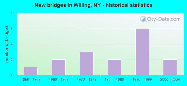
- New bridges - historical statistics
- 11950-1959
- 21960-1969
- 31970-1979
- 21980-1989
- 61990-1999
- 22000-2009

- Reconstructed bridges - Historical Statistics
- 11980-1989
- 31990-1999

- Bridge Condition - Deck
- 7.1%Excellent
- 28.6%Very good
- 42.9%Good
- 21.4%Satisfactory

- Bridge Condition - Superstructure
- 7.1%Excellent
- 14.3%Very good
- 50.0%Good
- 7.1%Satisfactory
- 14.3%Fair
- 7.1%Poor

- Bridge Condition - Substructure
- 7.1%Excellent
- 21.4%Very good
- 21.4%Good
- 21.4%Satisfactory
- 21.4%Fair
- 7.1%Critical

- Bridge Condition - Channel
- 12.5%Very good
- 6.3%Good
- 31.3%Satisfactory
- 25.0%Fair
- 18.8%Poor
- 6.3%Serious
Find on map >> Show street view
Structure Number: 101489, Location: 0.7 MI SE OF SHONGO (Lat: 42.006889, Lng: -77.887764), Route carried "on" structure: State highway 19, Year Built: 1994, Status: Open, Structure Length: 0.88m (2.89ft), Average Daily Traffic: 1,610 (year 2020), Truck Traffic: 8%, Average Future Daily Traffic: 1,625 (year 2040), Design Load: HS 25 or greater, Features Intersected: JOHNSON CREEK
Minimum Vertical Clearance: 30+ m (98+ ft), Kilometerpoint: 1.110, Lanes on structure: 2, Base Highway Network: Yes, Owner: State Highway Agency, Approaching Roadway Width: 12.2m (40.0ft), Skew: 3 degrees, Material/Design: Concrete, Design/Construction: Culvert, Number Of Spans In Main Unit: 1, Length of Maximum Span: 6.7m (22.0ft)
Condition: Channel: Fair, Culverts: Very good, Operating Rating: 84.4 metric tons, Method Used To Determine Operating Rating: Load Factor (LF), Inventory Rating: 41.7 metric tons, Method Used To Determine Inventory Rating: Load Factor (LF), Structural Evaluation: Equal to present desirable criteria, Waterway Adequacy: Somewhat better than minimum adequacy, Approach Roadway Alignment: Equal to present desirable criteria, Length Of Structure Improvement: 0.88m (2.89ft), Designated Inspection Frequency: Every 24 months, Inspection Date: August 2020, Bridge Improvement Cost: $532,000, Roadway Improvement Cost: $311,000, Total Project Cost: $843,000 ( Estimate for 2021), Wearing Surface/Protective System: Wearing Surface: Bituminous
Find on map >> Show street view
Structure Number: 10149, Location: 5.3MI S INTERS RTS 248&19 (Lat: 42.015269, Lng: -77.894883), Route carried "on" structure: State highway 19, Year Built: 1990, Status: Open, Structure Length: 4.63m (15.19ft), Average Daily Traffic: 1,610 (year 2020), Truck Traffic: 8%, Average Future Daily Traffic: 1,625 (year 2040), Design Load: HS 20, Features Intersected: GENESEE RIVER
Minimum Vertical Clearance: 30+ m (98+ ft), Kilometerpoint: 2.204, Lanes on structure: 2, Base Highway Network: Yes, Owner: State Highway Agency, Approaching Roadway Width: 12.2m (40.0ft), Material/Design: Steel, Design/Construction: Stringer/Multi-beam, Number Of Spans In Main Unit: 1, Length of Maximum Span: 45.7m (149.9ft), Curb-To-Curb Width: 12.2m (40.0ft), Out-to-Out Width: 12.8m (42.0ft)
Condition: Deck: Satisfactory, Superstructure: Satisfactory, Substructure: Satisfactory, Channel: Satisfactory, Inventory Rating: 61.7 metric tons, Method Used To Determine Inventory Rating: Load Factor (LF), Structural Evaluation: Equal to present minimum criteria, Deck Geometry: Better than present minimum criteria, Waterway Adequacy: Somewhat better than minimum adequacy, Approach Roadway Alignment: Equal to present desirable criteria, Length Of Structure Improvement: 4.63m (15.19ft), Designated Inspection Frequency: Every 24 months, Inspection Date: August 2021, Bridge Improvement Cost: $1,718,000, Roadway Improvement Cost: $1,006,000, Total Project Cost: $2,725,000 ( Estimate for 2021), Deck Structure Type: Concrete Cast-file-Place, Wearing Surface/Protective System: Wearing Surface: Integral Concrete, Deck Protection: Epoxy Coated Reinforcing
Find on map >> Show street view
Structure Number: 101491, Location: 0.1 MI N OF SHONGO (Lat: 42.020308, Lng: -77.897456), Route carried "on" structure: State highway 19, Year Built: 1994, Status: Open, Structure Length: 0.85m (2.79ft), Average Daily Traffic: 1,610 (year 2020), Truck Traffic: 8%, Average Future Daily Traffic: 1,625 (year 2040), Design Load: HS 25 or greater, Features Intersected: GRAVES CREEK
Minimum Vertical Clearance: 30+ m (98+ ft), Kilometerpoint: 2.848, Lanes on structure: 2, Base Highway Network: Yes, Owner: State Highway Agency, Approaching Roadway Width: 12.2m (40.0ft), Skew: 1 degrees, Material/Design: Concrete, Design/Construction: Culvert, Number Of Spans In Main Unit: 1, Length of Maximum Span: 7.3m (24.0ft), Curb-To-Curb Width: 12.2m (40.0ft), Out-to-Out Width: 12.8m (42.0ft)
Condition: Channel: Poor, Culverts: Very good, Operating Rating: 88.9 metric tons, Method Used To Determine Operating Rating: Load Factor (LF), Inventory Rating: 41.7 metric tons, Method Used To Determine Inventory Rating: Load Factor (LF), Structural Evaluation: Equal to present desirable criteria, Deck Geometry: Better than present minimum criteria, Waterway Adequacy: Somewhat better than minimum adequacy, Approach Roadway Alignment: Equal to present desirable criteria, Length Of Structure Improvement: 0.85m (2.79ft), Designated Inspection Frequency: Every 24 months, Inspection Date: August 2020, Bridge Improvement Cost: $377,000, Roadway Improvement Cost: $221,000, Total Project Cost: $598,000 ( Estimate for 2021), Deck Structure Type: Concrete Cast-file-Place, Wearing Surface/Protective System: Wearing Surface: Integral Concrete, Deck Protection: Epoxy Coated Reinforcing
Find on map >> Show street view
Structure Number: 101492, Location: 2.8 MI NW OF SHONGO (Lat: 42.051717, Lng: -77.915878), Route carried "on" structure: State highway 19, Year Built: 1996, Status: Open, Structure Length: 0.82m (2.69ft), Average Daily Traffic: 1,945 (year 2019), Truck Traffic: 10%, Average Future Daily Traffic: 1,963 (year 2040), Design Load: HS 25 or greater, Features Intersected: BEECH HILL CREEK
Minimum Vertical Clearance: 30+ m (98+ ft), Kilometerpoint: 6.854, Lanes on structure: 2, Base Highway Network: Yes, Owner: State Highway Agency, Approaching Roadway Width: 12.2m (40.0ft), Skew: 4 degrees, Material/Design: Concrete, Design/Construction: Frame, Number Of Spans In Main Unit: 1, Length of Maximum Span: 7.9m (25.9ft), Curb-To-Curb Width: 12.2m (40.0ft), Out-to-Out Width: 13.1m (43.0ft)
Condition: Deck: Satisfactory, Superstructure: Good, Substructure: Good, Channel: Fair, Operating Rating: 71.7 metric tons, Method Used To Determine Operating Rating: Load Factor (LF), Inventory Rating: 44.5 metric tons, Method Used To Determine Inventory Rating: Load Factor (LF), Structural Evaluation: Better than present minimum criteria, Deck Geometry: Better than present minimum criteria, Waterway Adequacy: Equal to present minimum criteria, Approach Roadway Alignment: Equal to present desirable criteria, Length Of Structure Improvement: 0.82m (2.69ft), Designated Inspection Frequency: Every 24 months, Inspection Date: August 2020, Bridge Improvement Cost: $725,000, Roadway Improvement Cost: $424,000, Total Project Cost: $1,149,000 ( Estimate for 2021), Wearing Surface/Protective System: Wearing Surface: Bituminous, Membrane: Other
Find on map >> Show street view
Structure Number: 221518, Location: 0.7 MI S OF STANDARDS (Lat: 42.075858, Lng: -77.924653), Route carried "on" structure: Other road , Year Built: 1984, Status: Open, Structure Length: 4.39m (14.40ft), Average Daily Traffic: 460 (year 2020), Truck Traffic: 4%, Average Future Daily Traffic: 644 (year 2040), Design Load: HS 20, Features Intersected: GENESEE RIVER, Facility Carried by Structure: JACK BRIDGE ROAD
Minimum Vertical Clearance: 30+ m (98+ ft), Kilometerpoint: 0.386, Lanes on structure: 2, Owner: Town or Township Highway Agency, Approaching Roadway Width: 7.9m (25.9ft), Skew: 1 degrees, Material/Design: Steel, Design/Construction: Stringer/Multi-beam, Number Of Spans In Main Unit: 1, Length of Maximum Span: 42.9m (140.7ft), Curb-To-Curb Width: 7.9m (25.9ft), Out-to-Out Width: 8.5m (27.9ft)
Condition: Deck: Very good, Superstructure: Very good, Substructure: Very good, Channel: Very good, Inventory Rating: 77.1 metric tons, Method Used To Determine Inventory Rating: Load Factor (LF), Structural Evaluation: Equal to present desirable criteria, Deck Geometry: Somewhat better than minimum adequacy, Waterway Adequacy: Superior to present desirable criteria, Approach Roadway Alignment: Equal to present desirable criteria, Length Of Structure Improvement: 4.38m (14.37ft), Designated Inspection Frequency: Every 24 months, Inspection Date: August 2020, Bridge Improvement Cost: $1,046,000, Roadway Improvement Cost: $613,000, Total Project Cost: $1,659,000 ( Estimate for 2021), Deck Structure Type: Concrete Cast-file-Place, Wearing Surface/Protective System: Wearing Surface: Integral Concrete, Deck Protection: Epoxy Coated Reinforcing
Find on map >> Show street view
Structure Number: 221519, Location: 0.7 MI NW OF SHONGO (Lat: 42.024653, Lng: -77.905317), Route carried "on" structure: Other road , Year Built: 1975, Year Reconstructed: 1992, Status: Open, Structure Length: 2.44m (8.01ft), Average Daily Traffic: 269 (year 2020), Truck Traffic: 7%, Average Future Daily Traffic: 377 (year 2040), Features Intersected: GENESEE RIVER, Facility Carried by Structure: GRAVES ROAD
Minimum Vertical Clearance: 30+ m (98+ ft), Kilometerpoint: 0.563, Lanes on structure: 2, Owner: Town or Township Highway Agency, Approaching Roadway Width: 5.8m (19.0ft), Material/Design: Steel, Design/Construction: Stringer/Multi-beam, Number Of Spans In Main Unit: 1, Length of Maximum Span: 23.7m (77.8ft), Curb-To-Curb Width: 7.1m (23.3ft), Out-to-Out Width: 7.7m (25.3ft)
Condition: Deck: Very good, Superstructure: Fair, Substructure: Critical, Channel: Serious, Operating Rating: 47.2 metric tons, Method Used To Determine Operating Rating: Load Factor (LF), Inventory Rating: 29.0 metric tons, Method Used To Determine Inventory Rating: Load Factor (LF), Structural Evaluation: High priority of replacement, Deck Geometry: Meets minimum limits, Waterway Adequacy: Better than present minimum criteria, Approach Roadway Alignment: Equal to present minimum criteria, Length Of Structure Improvement: 2.43m (7.97ft), Designated Inspection Frequency: Every 24 months, Underwater Inspection Frequency: Every 60 months, Inspection Date: May 2021, Underwater Inspection Date: June 2020, Bridge Improvement Cost: $875,000, Roadway Improvement Cost: $512,000, Total Project Cost: $1,387,000 ( Estimate for 2021), Deck Structure Type: Wood or Timber, Wearing Surface/Protective System: Wearing Surface: Bituminous, Membrane: Other
Find on map >> Show street view
Structure Number: 22152, Location: IN HALLSPORT (Lat: 42.075781, Lng: -77.851947), Route carried "on" structure: Other road , Year Built: 1977, Year Reconstructed: 1996, Status: Open, Structure Length: 0.91m (2.99ft), Average Daily Traffic: 142 (year 2019), Truck Traffic: 5%, Average Future Daily Traffic: 199 (year 2039), Design Load: HS 25 or greater, Features Intersected: TRIB CHENUNDA CRK, Facility Carried by Structure: STOUT ROAD
Minimum Vertical Clearance: 30+ m (98+ ft), Kilometerpoint: 0.080, Lanes on structure: 2, Owner: Town or Township Highway Agency, Approaching Roadway Width: 6.7m (22.0ft), Material/Design: Wood or Timber, Design/Construction: Slab, Number Of Spans In Main Unit: 1, Length of Maximum Span: 8.2m (26.9ft), Curb-To-Curb Width: 7.3m (24.0ft), Out-to-Out Width: 8.0m (26.2ft)
Condition: Deck: Very good, Superstructure: Good, Substructure: Good, Channel: Fair, Operating Rating: 89.8 metric tons, Method Used To Determine Operating Rating: Load Factor (LF), Inventory Rating: 64.4 metric tons, Method Used To Determine Inventory Rating: Load Factor (LF), Structural Evaluation: Better than present minimum criteria, Deck Geometry: Somewhat better than minimum adequacy, Waterway Adequacy: Superior to present desirable criteria, Approach Roadway Alignment: Equal to present desirable criteria, Length Of Structure Improvement: 0.91m (2.99ft), Designated Inspection Frequency: Every 24 months, Inspection Date: September 2020, Bridge Improvement Cost: $356,000, Roadway Improvement Cost: $209,000, Total Project Cost: $565,000 ( Estimate for 2021), Wearing Surface/Protective System: Wearing Surface: Bituminous, Membrane: Other
Find on map >> Show street view
Structure Number: 221521, Location: 1.9 MI SE OF STANNARDS (Lat: 42.078075, Lng: -77.890236), Route carried "on" structure: Other road , Year Built: 1969, Status: Open, Structure Length: 1.10m (3.61ft), Average Daily Traffic: 24 (year 2020), Average Future Daily Traffic: 34 (year 2040), Features Intersected: CHENUNDA CREEK, Facility Carried by Structure: ROESKE ROAD
Minimum Vertical Clearance: 30+ m (98+ ft), Kilometerpoint: 0.161, Lanes on structure: 2, Owner: Town or Township Highway Agency, Approaching Roadway Width: 5.5m (18.0ft), Skew: 1 degrees, Material/Design: Steel, Design/Construction: Stringer/Multi-beam, Number Of Spans In Main Unit: 1, Length of Maximum Span: 10.0m (32.8ft), Curb-To-Curb Width: 6.8m (22.3ft), Out-to-Out Width: 7.5m (24.6ft)
Condition: Deck: Good, Superstructure: Poor, Substructure: Fair, Channel: Poor, Operating Rating: 49.9 metric tons, Method Used To Determine Operating Rating: Load Factor (LF), Inventory Rating: 29.9 metric tons, Method Used To Determine Inventory Rating: Load Factor (LF), Structural Evaluation: Meets minimum limits, Deck Geometry: Somewhat better than minimum adequacy, Waterway Adequacy: Meets minimum limits, Approach Roadway Alignment: Somewhat better than minimum adequacy, Length Of Structure Improvement: 1.09m (3.58ft), Designated Inspection Frequency: Every 24 months, Underwater Inspection Frequency: Every 60 months, Inspection Date: August 2021, Underwater Inspection Date: June 2020, Bridge Improvement Cost: $417,000, Roadway Improvement Cost: $244,000, Total Project Cost: $661,000 ( Estimate for 2021), Deck Structure Type: Wood or Timber, Wearing Surface/Protective System: Wearing Surface: Bituminous
Find on map >> Show street view
Structure Number: 221522, Location: 0.8 MI E OF STANDARDS (Lat: 42.084961, Lng: -77.909647), Route carried "on" structure: Other road , Year Built: 1957, Year Reconstructed: 1999, Status: Open, Structure Length: 1.52m (4.99ft), Average Daily Traffic: 195 (year 2020), Truck Traffic: 6%, Average Future Daily Traffic: 273 (year 2040), Design Load: HS 25 or greater, Features Intersected: CHENUNDA CREEK, Facility Carried by Structure: DUTCH HILL ROAD
Minimum Vertical Clearance: 30+ m (98+ ft), Kilometerpoint: 0.080, Lanes on structure: 2, Owner: Town or Township Highway Agency, Approaching Roadway Width: 6.1m (20.0ft), Skew: 1 degrees, Material/Design: Wood or Timber, Design/Construction: Stringer/Multi-beam, Number Of Spans In Main Unit: 1, Length of Maximum Span: 14.6m (47.9ft), Curb-To-Curb Width: 7.3m (24.0ft), Out-to-Out Width: 7.6m (24.9ft)
Condition: Deck: Good, Superstructure: Very good, Substructure: Satisfactory, Channel: Satisfactory, Operating Rating: 66.2 metric tons, Method Used To Determine Operating Rating: Load Factor (LF), Inventory Rating: 44.5 metric tons, Method Used To Determine Inventory Rating: Load Factor (LF), Structural Evaluation: Equal to present minimum criteria, Deck Geometry: Somewhat better than minimum adequacy, Waterway Adequacy: Better than present minimum criteria, Approach Roadway Alignment: Equal to present desirable criteria, Length Of Structure Improvement: 1.52m (4.99ft), Designated Inspection Frequency: Every 24 months, Inspection Date: September 2021, Bridge Improvement Cost: $487,000, Roadway Improvement Cost: $285,000, Total Project Cost: $772,000 ( Estimate for 2021), Deck Structure Type: Wood or Timber, Wearing Surface/Protective System: Wearing Surface: Bituminous, Membrane: Other
Find on map >> Show street view
Structure Number: 221523, Location: 1.3 MILES SW OF STANNARDS (Lat: 42.067628, Lng: -77.928139), Route carried "on" structure: Other road , Year Built: 1964, Year Reconstructed: 1995, Status: Open, Structure Length: 1.04m (3.41ft), Average Daily Traffic: 246 (year 2019), Truck Traffic: 1%, Average Future Daily Traffic: 344 (year 2039), Design Load: HS 25 or greater, Features Intersected: FORD BROOK, Facility Carried by Structure: RIVER ROAD
Minimum Vertical Clearance: 30+ m (98+ ft), Kilometerpoint: 2.317, Lanes on structure: 2, Owner: Town or Township Highway Agency, Approaching Roadway Width: 6.1m (20.0ft), Material/Design: Wood or Timber, Design/Construction: Slab, Number Of Spans In Main Unit: 1, Length of Maximum Span: 9.4m (30.8ft), Curb-To-Curb Width: 8.3m (27.2ft), Out-to-Out Width: 8.8m (28.9ft)
Condition: Deck: Good, Superstructure: Good, Substructure: Good, Channel: Satisfactory, Operating Rating: 74.4 metric tons, Method Used To Determine Operating Rating: Load Factor (LF), Inventory Rating: 50.8 metric tons, Method Used To Determine Inventory Rating: Load Factor (LF), Structural Evaluation: Better than present minimum criteria, Deck Geometry: Somewhat better than minimum adequacy, Waterway Adequacy: Meets minimum limits, Approach Roadway Alignment: Better than present minimum criteria, Length Of Structure Improvement: 1.03m (3.38ft), Designated Inspection Frequency: Every 24 months, Inspection Date: August 2021, Bridge Improvement Cost: $383,000, Roadway Improvement Cost: $224,000, Total Project Cost: $607,000 ( Estimate for 2021), Wearing Surface/Protective System: Wearing Surface: Bituminous, Membrane: Other
Find on map >> Show street view
Structure Number: 221525, Location: 3.0 MI SW WHITESVILLE (Lat: 42.007819, Lng: -77.841622), Route carried "on" structure: Alternate Other road , Year Built: 1979, Status: Open, Structure Length: 1.37m (4.49ft), Average Daily Traffic: 46 (year 2020), Average Future Daily Traffic: 64 (year 2040), Design Load: H 20, Features Intersected: CRYDER CREEK, Facility Carried by Structure: PAYNESVILLE HL RD
Minimum Vertical Clearance: 30+ m (98+ ft), Kilometerpoint: 0.225, Lanes on structure: 2, Owner: Town or Township Highway Agency, Approaching Roadway Width: 5.8m (19.0ft), Material/Design: Steel, Design/Construction: Stringer/Multi-beam, Number Of Spans In Main Unit: 1, Length of Maximum Span: 13.4m (44.0ft), Curb-To-Curb Width: 7.1m (23.3ft), Out-to-Out Width: 7.3m (24.0ft)
Condition: Deck: Satisfactory, Superstructure: Fair, Substructure: Fair, Channel: Fair, Operating Rating: 15.9 metric tons, Method Used To Determine Operating Rating: Load and Resistance Factor Rating (LRFR) rating reported by rating factor(RF) method using HL-93 loadings, Inventory Rating: 12.3 metric tons, Method Used To Determine Inventory Rating: Load and Resistance Factor Rating (LRFR) rating reported by rating factor(RF) method using HL-93 loadings, Structural Evaluation: Meets minimum limits, Deck Geometry: Somewhat better than minimum adequacy, Waterway Adequacy: Superior to present desirable criteria, Approach Roadway Alignment: Equal to present minimum criteria, Length Of Structure Improvement: 1.37m (4.49ft), Designated Inspection Frequency: Every 24 months, Inspection Date: September 2020, Bridge Improvement Cost: $527,000, Roadway Improvement Cost: $309,000, Total Project Cost: $836,000 ( Estimate for 2021), Deck Structure Type: Corrugated Steel, Wearing Surface/Protective System: Wearing Surface: Bituminous
Find on map >> Show street view
Structure Number: 221526, Location: 2.5 MI NW OF SHONGO (Lat: 42.026989, Lng: -77.937311), Route carried "on" structure: Other road , Year Built: 1990, Status: Open, Structure Length: 0.91m (2.99ft), Average Daily Traffic: 269 (year 2020), Truck Traffic: 7%, Average Future Daily Traffic: 377 (year 2040), Design Load: HS 20, Features Intersected: OREBED CREEK, Facility Carried by Structure: GRAVES ROAD
Minimum Vertical Clearance: 30+ m (98+ ft), Kilometerpoint: 3.492, Lanes on structure: 2, Owner: Town or Township Highway Agency, Approaching Roadway Width: 6.1m (20.0ft), Skew: 5 degrees, Material/Design: Wood or Timber, Design/Construction: Slab, Number Of Spans In Main Unit: 1, Length of Maximum Span: 8.8m (28.9ft), Curb-To-Curb Width: 7.2m (23.6ft), Out-to-Out Width: 7.8m (25.6ft)
Condition: Deck: Good, Superstructure: Good, Substructure: Satisfactory, Channel: Satisfactory, Operating Rating: 61.7 metric tons, Method Used To Determine Operating Rating: Load Factor (LF), Inventory Rating: 42.6 metric tons, Method Used To Determine Inventory Rating: Load Factor (LF), Structural Evaluation: Equal to present minimum criteria, Deck Geometry: Meets minimum limits, Waterway Adequacy: Better than present minimum criteria, Approach Roadway Alignment: Equal to present desirable criteria, Length Of Structure Improvement: 0.91m (2.99ft), Designated Inspection Frequency: Every 24 months, Inspection Date: August 2020, Bridge Improvement Cost: $463,000, Roadway Improvement Cost: $271,000, Total Project Cost: $734,000 ( Estimate for 2021), Wearing Surface/Protective System: Wearing Surface: Other
Find on map >> Show street view
Structure Number: 221527, Location: 0.7 MI NW OF HALLSPORT (Lat: 42.080325, Lng: -77.866478), Route carried "on" structure: Other road , Year Built: 1988, Status: Open, Structure Length: 1.01m (3.31ft), Average Daily Traffic: 155 (year 2018), Truck Traffic: 6%, Average Future Daily Traffic: 217 (year 2038), Features Intersected: CHENUNDA CREEK, Facility Carried by Structure: FULMER VALLEY RD
Minimum Vertical Clearance: 30+ m (98+ ft), Kilometerpoint: 0.370, Lanes on structure: 2, Owner: Town or Township Highway Agency, Approaching Roadway Width: 5.5m (18.0ft), Skew: 1 degrees, Material/Design: Wood or Timber, Design/Construction: Slab, Number Of Spans In Main Unit: 1, Length of Maximum Span: 9.7m (31.8ft), Curb-To-Curb Width: 7.1m (23.3ft), Out-to-Out Width: 7.8m (25.6ft)
Condition: Deck: Good, Superstructure: Good, Substructure: Fair, Channel: Poor, Operating Rating: 50.8 metric tons, Method Used To Determine Operating Rating: Load Factor (LF), Inventory Rating: 34.5 metric tons, Method Used To Determine Inventory Rating: Load Factor (LF), Structural Evaluation: Somewhat better than minimum adequacy, Deck Geometry: Meets minimum limits, Waterway Adequacy: Better than present minimum criteria, Approach Roadway Alignment: Equal to present desirable criteria, Length Of Structure Improvement: 1.00m (3.28ft), Designated Inspection Frequency: Every 24 months, Inspection Date: August 2020, Bridge Improvement Cost: $493,000, Roadway Improvement Cost: $289,000, Total Project Cost: $782,000 ( Estimate for 2021), Wearing Surface/Protective System: Wearing Surface: Bituminous
Find on map >> Show street view
Structure Number: 333067, Location: 2.6 MI NW OF SHONGO (Lat: 42.032594, Lng: -77.940886), Route carried "on" structure: County highway , Year Built: 2007, Status: Open, Structure Length: 1.16m (3.81ft), Average Daily Traffic: 566 (year 2020), Truck Traffic: 14%, Average Future Daily Traffic: 792 (year 2040), Features Intersected: MARSH CREEK, Facility Carried by Structure: COUNTY RD 29
Minimum Vertical Clearance: 30+ m (98+ ft), Kilometerpoint: 5.535, Lanes on structure: 2, Owner: County Highway Agency, Approaching Roadway Width: 8.8m (28.9ft), Skew: 3 degrees, Material/Design: Wood or Timber, Design/Construction: Slab, Number Of Spans In Main Unit: 1, Length of Maximum Span: 9.8m (32.2ft), Curb-To-Curb Width: 9.1m (29.9ft), Out-to-Out Width: 9.8m (32.2ft)
Condition: Deck: Excellent, Superstructure: Excellent, Substructure: Excellent, Channel: Good, Operating Rating: 79.5 metric tons, Method Used To Determine Operating Rating: Field evaluation and documented engineering judgment, Inventory Rating: 40.8 metric tons, Method Used To Determine Inventory Rating: Field evaluation and documented engineering judgment, Structural Evaluation: Superior to present desirable criteria, Deck Geometry: Equal to present minimum criteria, Waterway Adequacy: Somewhat better than minimum adequacy, Approach Roadway Alignment: Equal to present minimum criteria, Length Of Structure Improvement: 1.15m (3.77ft), Designated Inspection Frequency: Every 24 months, Inspection Date: August 2021, Bridge Improvement Cost: $394,000, Roadway Improvement Cost: $231,000, Total Project Cost: $625,000 ( Estimate for 2021), Wearing Surface/Protective System: Wearing Surface: Bituminous, Membrane: Other
Find on map >> Show street view
Structure Number: 333068, Location: 2.8 MILES NW OF SHONGO (Lat: 42.048525, Lng: -77.931297), Route carried "on" structure: County highway , Year Built: 1997, Status: Open, Structure Length: 1.13m (3.71ft), Average Daily Traffic: 566 (year 2020), Truck Traffic: 14%, Average Future Daily Traffic: 792 (year 2040), Design Load: HS 25 or greater, Features Intersected: MARSH CREEK, Facility Carried by Structure: COUNTY ROAD 29
Minimum Vertical Clearance: 30+ m (98+ ft), Kilometerpoint: 7.611, Lanes on structure: 2, Owner: County Highway Agency, Approaching Roadway Width: 6.7m (22.0ft), Skew: 4 degrees, Material/Design: Wood or Timber, Design/Construction: Slab, Number Of Spans In Main Unit: 1, Length of Maximum Span: 10.9m (35.8ft), Curb-To-Curb Width: 9.1m (29.9ft), Out-to-Out Width: 9.8m (32.2ft)
Condition: Deck: Good, Superstructure: Good, Substructure: Very good, Channel: Satisfactory, Operating Rating: 65.3 metric tons, Method Used To Determine Operating Rating: Load Factor (LF), Inventory Rating: 43.5 metric tons, Method Used To Determine Inventory Rating: Load Factor (LF), Structural Evaluation: Better than present minimum criteria, Deck Geometry: Equal to present minimum criteria, Waterway Adequacy: Meets minimum limits, Approach Roadway Alignment: Better than present minimum criteria, Length Of Structure Improvement: 1.12m (3.67ft), Designated Inspection Frequency: Every 24 months, Inspection Date: August 2021, Bridge Improvement Cost: $918,000, Roadway Improvement Cost: $537,000, Total Project Cost: $1,455,000 ( Estimate for 2021), Wearing Surface/Protective System: Wearing Surface: Bituminous, Membrane: Other
Find on map >> Show street view
Structure Number: 333069, Location: 2.7 MI NW OF SHONGO (Lat: 42.048494, Lng: -77.928583), Route carried "on" structure: County highway , Year Built: 2002, Status: Open, Structure Length: 4.18m (13.71ft), Average Daily Traffic: 566 (year 2020), Truck Traffic: 14%, Average Future Daily Traffic: 792 (year 2040), Design Load: HS 25 or greater, Features Intersected: GENESEE RIVER, Facility Carried by Structure: CR 29, STONE DAM R
Minimum Vertical Clearance: 30+ m (98+ ft), Kilometerpoint: 7.836, Lanes on structure: 2, Owner: County Highway Agency, Approaching Roadway Width: 8.5m (27.9ft), Material/Design: Steel, Design/Construction: Stringer/Multi-beam, Number Of Spans In Main Unit: 1, Length of Maximum Span: 41.4m (135.8ft), Curb-To-Curb Width: 9.1m (29.9ft), Out-to-Out Width: 10.1m (33.1ft)
Condition: Deck: Very good, Superstructure: Good, Substructure: Very good, Channel: Very good, Operating Rating: 34.0 metric tons, Method Used To Determine Operating Rating: Load and Resistance Factor Rating (LRFR) rating reported by rating factor(RF) method using HL-93 loadings, Inventory Rating: 26.2 metric tons, Method Used To Determine Inventory Rating: Load and Resistance Factor Rating (LRFR) rating reported by rating factor(RF) method using HL-93 loadings, Structural Evaluation: Equal to present minimum criteria, Deck Geometry: Equal to present minimum criteria, Waterway Adequacy: Equal to present desirable criteria, Approach Roadway Alignment: Equal to present desirable criteria, Length Of Structure Improvement: 4.17m (13.68ft), Designated Inspection Frequency: Every 24 months, Inspection Date: April 2020, Bridge Improvement Cost: $1,678,000, Roadway Improvement Cost: $982,000, Total Project Cost: $2,660,000 ( Estimate for 2021), Deck Structure Type: Concrete Cast-file-Place, Wearing Surface/Protective System: Wearing Surface: Integral Concrete