Bridge Statistics for Williamsport, Maryland (MD)
Condition, Traffic, Stress, Structural Evaluation, Project Costs
- National Bridge Inventory (NBI) Statistics
- 18Number of bridges
- 525ft / 160mTotal length
- $175,777,000Total costs
- 322,888Total average daily traffic
- 58,470Total average daily truck traffic
- National Bridge Inventory (NBI) Registered Bridges for Williamsport
- No street view available for this location
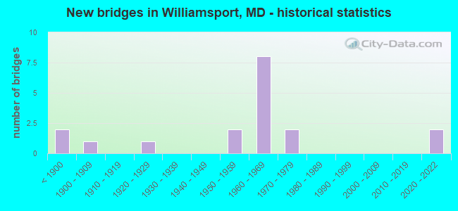
- New bridges - historical statistics
- 2Before 1900
- 11900-1909
- 11920-1929
- 21950-1959
- 81960-1969
- 21970-1979
- 22020-2022

- Reconstructed bridges - Historical Statistics
- 21980-1989
- 01990-1999
- 22000-2009
- 12010-2019
- 22020-2022


- Bridge Condition - Deck
- 45.5%Very good
- 18.2%Good
- 9.1%Satisfactory
- 27.3%Fair

- Bridge Condition - Superstructure
- 36.4%Very good
- 18.2%Good
- 9.1%Satisfactory
- 36.4%Fair

- Bridge Condition - Substructure
- 36.4%Very good
- 36.4%Good
- 18.2%Satisfactory
- 9.1%Fair

- Bridge Condition - Channel
- 41.7%Good
- 50.0%Satisfactory
- 8.3%Fair

- Bridge Condition - Culverts
- 60.0%Good
- 40.0%Satisfactory
Find on map >> Show street view
Structure Number: 10000021000101, Location: ON WEST VIRGINIA ST LINE (Lat: 39.599742, Lng: -77.826294), Route carried "on" structure: US 11, Year Built: 1909, Year Reconstructed: 1980, Status: Open, Structure Length: 51.85m (170.11ft), Average Daily Traffic: 5,882 (year 2009), Truck Traffic: 8%, Average Future Daily Traffic: 7,370 (year 2026), Design Load: HS 20, Features Intersected: POTOMAC RIVER, CSX TRANS
Minimum Vertical Clearance: 30+ m (98+ ft), Kilometerpoint: 0.274, Lanes on structure: 2, Owner: State Highway Agency, Approaching Roadway Width: 9.1m (29.9ft), Material/Design: Steel, Design/Construction: Stringer/Multi-beam, Number Of Spans In Main Unit: 17, Length of Maximum Span: 30.5m (100.1ft), Curb-To-Curb Width: 9.1m (29.9ft), Out-to-Out Width: 10.1m (33.1ft)
Condition: Deck: Fair, Superstructure: Fair, Substructure: Good, Channel: Good, Operating Rating: 89.3 metric tons, Method Used To Determine Operating Rating: Load Factor (LF), Inventory Rating: 53.5 metric tons, Method Used To Determine Inventory Rating: Load Factor (LF), Structural Evaluation: Somewhat better than minimum adequacy, Deck Geometry: Meets minimum limits, Underclear: Superior to present desirable criteria, Waterway Adequacy: Somewhat better than minimum adequacy, Approach Roadway Alignment: Equal to present minimum criteria, Designated Inspection Frequency: Every 24 months, Underwater Inspection Frequency: Every 48 months, Inspection Date: May 2020, Underwater Inspection Date: July 2019, Deck Structure Type: Concrete Cast-file-Place, Wearing Surface/Protective System: Wearing Surface: Monolithic Concrete, Deck Protection: Epoxy Coated Reinforcing
Find on map >> Show street view
Structure Number: 10000021003601, Location: 0.20 MILE WEST OF US 11 (Lat: 39.603300, Lng: -77.822181), Route carried "on" structure: State highway 68, Year Built: 1829, Year Reconstructed: 1987, Status: Open, Structure Length: 5.09m (16.70ft), Average Daily Traffic: 4,532 (year 2009), Truck Traffic: 8%, Average Future Daily Traffic: 5,767 (year 2026), Features Intersected: CONOCOCHEAGUE CREEK
Minimum Vertical Clearance: 30+ m (98+ ft), Kilometerpoint: 11.440, Lanes on structure: 2, Owner: State Highway Agency, Approaching Roadway Width: 7.0m (23.0ft), Material/Design: Masonry, Design/Construction: Arch - Deck, Number Of Spans In Main Unit: 4, Length of Maximum Span: 11.3m (37.1ft), Curb or Sidewalk Widths: Left: 0.0m, Right: 1.6m (5.2ft), Curb-To-Curb Width: 7.1m (23.3ft), Out-to-Out Width: 9.6m (31.5ft)
Condition: Deck: Satisfactory, Superstructure: Fair, Substructure: Good, Channel: Satisfactory, Operating Rating: 72.6 metric tons, Method Used To Determine Operating Rating: Load Factor (LF), Inventory Rating: 43.5 metric tons, Method Used To Determine Inventory Rating: Load Factor (LF), Structural Evaluation: Somewhat better than minimum adequacy, Deck Geometry: High priority of replacement, Waterway Adequacy: Better than present minimum criteria, Approach Roadway Alignment: High priority of corrective action, Length Of Structure Improvement: 5.09m (16.70ft), Designated Inspection Frequency: Every 24 months, Inspection Date: January 2021, Bridge Improvement Cost: $316,000, Roadway Improvement Cost: $32,000, Total Project Cost: $348,000, Deck Structure Type: Concrete Cast-file-Place, Wearing Surface/Protective System: Wearing Surface: Bituminous
Find on map >> Show street view
Structure Number: 10000021005701, Location: 1.08 MILES NORTH OF US 11 (Lat: 39.614714, Lng: -77.812136), Route carried "on" structure: State highway 63, Year Built: 1959, Year Reconstructed: 2011, Status: Open, Structure Length: 4.66m (15.29ft), Average Daily Traffic: 12,600 (year 2009), Truck Traffic: 15%, Average Future Daily Traffic: 19,500 (year 2030), Design Load: HS 20, Features Intersected: CSX TRANS.
Minimum Vertical Clearance: 30+ m (98+ ft), Kilometerpoint: 14.674, Lanes on structure: 2, Owner: State Highway Agency, Approaching Roadway Width: 13.4m (44.0ft), Skew: 2 degrees, Material/Design: Steel, Design/Construction: Stringer/Multi-beam, Number Of Spans In Main Unit: 3, Length of Maximum Span: 15.9m (52.2ft), Curb-To-Curb Width: 9.8m (32.2ft), Out-to-Out Width: 10.7m (35.1ft)
Condition: Deck: Good, Superstructure: Good, Substructure: Good, Operating Rating: 83.0 metric tons, Method Used To Determine Operating Rating: Load Factor (LF), Inventory Rating: 49.9 metric tons, Method Used To Determine Inventory Rating: Load Factor (LF), Structural Evaluation: Better than present minimum criteria, Deck Geometry: Meets minimum limits, Underclear: Meets minimum limits, Approach Roadway Alignment: Equal to present desirable criteria, Length Of Structure Improvement: 4.66m (15.29ft), Designated Inspection Frequency: Every 24 months, Inspection Date: September 2020, Bridge Improvement Cost: $326,000, Roadway Improvement Cost: $33,000, Total Project Cost: $359,000, Deck Structure Type: Concrete Cast-file-Place, Wearing Surface/Protective System: Wearing Surface: Monolithic Concrete
Find on map >> Show street view
Structure Number: 10000021005802, Location: 1.05 MILES NORTH OF US 11 (Lat: 39.614328, Lng: -77.812153), Route carried "on" structure: State highway 63, Year Built: 1959, Status: Open, Structure Length: 0.82m (2.69ft), Average Daily Traffic: 9,581 (year 2009), Truck Traffic: 8%, Average Future Daily Traffic: 14,221 (year 2029), Design Load: HS 20, Features Intersected: BR OF CONOCOCHEAGUE CREE
Minimum Vertical Clearance: 30+ m (98+ ft), Kilometerpoint: 14.603, Lanes on structure: 2, Owner: State Highway Agency, Approaching Roadway Width: 13.4m (44.0ft), Material/Design: Concrete, Design/Construction: Culvert, Length of Maximum Span: 3.7m (12.1ft)
Condition: Channel: Satisfactory, Culverts: Satisfactory, Operating Rating: 32.7 metric tons, Method Used To Determine Operating Rating: Field evaluation and documented engineering judgment, Inventory Rating: 32.7 metric tons, Method Used To Determine Inventory Rating: Field evaluation and documented engineering judgment, Structural Evaluation: Equal to present minimum criteria, Waterway Adequacy: Equal to present desirable criteria, Approach Roadway Alignment: Equal to present desirable criteria, Designated Inspection Frequency: Every 24 months, Inspection Date: December 2020
Find on map >> Show street view
Structure Number: 100000210077011, Location: 0.88 MI N OF WEST VA LINE (Lat: 39.587394, Lng: -77.816144), Route carried "on" structure: Interstate 81, Year Built: 1965, Year Reconstructed: 2020, Status: Open, Structure Length: 5.03m (16.50ft), Average Daily Traffic: 61,300 (year 2011), Truck Traffic: 11%, Average Future Daily Traffic: 84,375 (year 2031), Features Intersected: MD 63/68
Minimum Vertical Clearance: 30+ m (98+ ft), Kilometerpoint: 1.397, Lanes on structure: 3, Lanes under structure: 4, Base Highway Network: Yes, Owner: State Highway Agency, Approaching Roadway Width: 17.1m (56.1ft), Material/Design: Steel, Design/Construction: Stringer/Multi-beam, Number Of Spans In Main Unit: 4, Length of Maximum Span: 14.0m (45.9ft), Curb-To-Curb Width: 17.4m (57.1ft), Out-to-Out Width: 18.5m (60.7ft)
Condition: Deck: Very good, Superstructure: Very good, Substructure: Very good, Operating Rating: 79.7 metric tons, Method Used To Determine Operating Rating: Load and Resistance Factor Rating (LRFR) rating reported by rating factor(RF) method using HL-93 loadings, Inventory Rating: 61.6 metric tons, Method Used To Determine Inventory Rating: Load and Resistance Factor Rating (LRFR) rating reported by rating factor(RF) method using HL-93 loadings, Structural Evaluation: Equal to present desirable criteria, Deck Geometry: Better than present minimum criteria, Underclear: Somewhat better than minimum adequacy, Approach Roadway Alignment: Equal to present desirable criteria, Length Of Structure Improvement: 783.76m (2571.39ft), Designated Inspection Frequency: Every 24 months, Inspection Date: July 2021, Bridge Improvement Cost: $36,280,000, Roadway Improvement Cost: $50,857,000, Total Project Cost: $87,137,000 ( Estimate for 2020), Deck Structure Type: Concrete Cast-file-Place, Wearing Surface/Protective System: Wearing Surface: Integral Concrete, Deck Protection: Epoxy Coated Reinforcing
Find on map >> Show street view
Structure Number: 100000210077012, Location: 0.88 MI N OF WEST VA LINE (Lat: 39.587878, Lng: -77.815931), Route carried "on" structure: Interstate 81, Year Built: 1965, Year Reconstructed: 2020, Status: Open, Structure Length: 5.03m (16.50ft), Average Daily Traffic: 61,300 (year 2011), Truck Traffic: 11%, Average Future Daily Traffic: 84,375 (year 2031), Features Intersected: MD 63/68
Minimum Vertical Clearance: 30+ m (98+ ft), Kilometerpoint: 1.397, Lanes on structure: 3, Lanes under structure: 4, Base Highway Network: Yes, Owner: State Highway Agency, Approaching Roadway Width: 17.1m (56.1ft), Material/Design: Steel, Design/Construction: Stringer/Multi-beam, Number Of Spans In Main Unit: 4, Length of Maximum Span: 14.0m (45.9ft), Curb-To-Curb Width: 17.4m (57.1ft), Out-to-Out Width: 18.5m (60.7ft)
Condition: Deck: Very good, Superstructure: Very good, Substructure: Very good, Operating Rating: 79.7 metric tons, Method Used To Determine Operating Rating: Load and Resistance Factor Rating (LRFR) rating reported by rating factor(RF) method using HL-93 loadings, Inventory Rating: 61.6 metric tons, Method Used To Determine Inventory Rating: Load and Resistance Factor Rating (LRFR) rating reported by rating factor(RF) method using HL-93 loadings, Structural Evaluation: Equal to present desirable criteria, Deck Geometry: Better than present minimum criteria, Underclear: Somewhat better than minimum adequacy, Approach Roadway Alignment: Equal to present desirable criteria, Length Of Structure Improvement: 783.76m (2571.39ft), Designated Inspection Frequency: Every 24 months, Inspection Date: July 2021, Bridge Improvement Cost: $36,280,000, Roadway Improvement Cost: $50,857,000, Total Project Cost: $87,137,000 ( Estimate for 2020), Deck Structure Type: Concrete Cast-file-Place, Wearing Surface/Protective System: Wearing Surface: Integral Concrete, Deck Protection: Epoxy Coated Reinforcing
Find on map >> Show street view
Structure Number: 100000210078011, Location: ON WEST VIRGINIA LINE (Lat: 39.584353, Lng: -77.830439), Route carried "on" structure: Interstate 81, Year Built: 2020, Status: Open, Structure Length: 36.09m (118.41ft), Average Daily Traffic: 61,300 (year 2011), Truck Traffic: 32%, Average Future Daily Traffic: 84,375 (year 2031), Features Intersected: POTOMAC RIVER
Minimum Vertical Clearance: 30+ m (98+ ft), Kilometerpoint: 0.161, Lanes on structure: 3, Base Highway Network: Yes, Owner: State Highway Agency, Approaching Roadway Width: 17.7m (58.1ft), Material/Design: Steel continuous, Design/Construction: Stringer/Multi-beam, Number Of Spans In Main Unit: 8, Length of Maximum Span: 57.9m (190.0ft), Curb-To-Curb Width: 17.7m (58.1ft), Out-to-Out Width: 18.9m (62.0ft)
Condition: Deck: Very good, Superstructure: Very good, Substructure: Very good, Channel: Good, Operating Rating: 56.7 metric tons, Method Used To Determine Operating Rating: Load and Resistance Factor Rating (LRFR) rating reported by rating factor(RF) method using HL-93 loadings, Inventory Rating: 43.7 metric tons, Method Used To Determine Inventory Rating: Load and Resistance Factor Rating (LRFR) rating reported by rating factor(RF) method using HL-93 loadings, Structural Evaluation: Equal to present desirable criteria, Deck Geometry: Better than present minimum criteria, Waterway Adequacy: Superior to present desirable criteria, Approach Roadway Alignment: Equal to present desirable criteria, Length Of Structure Improvement: 783.76m (2571.39ft), Designated Inspection Frequency: Every 24 months, Underwater Inspection Frequency: Every 48 months, Inspection Date: May 2021, Underwater Inspection Date: July 2018, Deck Structure Type: Concrete Cast-file-Place, Wearing Surface/Protective System: Wearing Surface: Monolithic Concrete
Find on map >> Show street view
Structure Number: 100000210078012, Location: ON WEST VIRGINIA LINE (Lat: 39.584689, Lng: -77.827278), Route carried "on" structure: Interstate 81, Year Built: 2020, Status: Open, Structure Length: 36.09m (118.41ft), Average Daily Traffic: 61,300 (year 2011), Truck Traffic: 32%, Average Future Daily Traffic: 84,375 (year 2031), Features Intersected: POTOMAC RIVER
Minimum Vertical Clearance: 30+ m (98+ ft), Kilometerpoint: 0.161, Lanes on structure: 3, Base Highway Network: Yes, Owner: State Highway Agency, Approaching Roadway Width: 17.7m (58.1ft), Material/Design: Steel continuous, Design/Construction: Stringer/Multi-beam, Number Of Spans In Main Unit: 8, Length of Maximum Span: 57.9m (190.0ft), Curb-To-Curb Width: 17.7m (58.1ft), Out-to-Out Width: 18.9m (62.0ft)
Condition: Deck: Very good, Superstructure: Very good, Substructure: Very good, Channel: Good, Operating Rating: 56.7 metric tons, Method Used To Determine Operating Rating: Load and Resistance Factor Rating (LRFR) rating reported by rating factor(RF) method using HL-93 loadings, Inventory Rating: 43.7 metric tons, Method Used To Determine Inventory Rating: Load and Resistance Factor Rating (LRFR) rating reported by rating factor(RF) method using HL-93 loadings, Structural Evaluation: Equal to present desirable criteria, Deck Geometry: Better than present minimum criteria, Waterway Adequacy: Superior to present desirable criteria, Approach Roadway Alignment: Equal to present desirable criteria, Length Of Structure Improvement: 783.76m (2571.39ft), Designated Inspection Frequency: Every 24 months, Underwater Inspection Frequency: Every 48 months, Inspection Date: May 2021, Underwater Inspection Date: July 2018, Deck Structure Type: Concrete Cast-file-Place, Wearing Surface/Protective System: Wearing Surface: Monolithic Concrete
Find on map >> Show street view
Structure Number: 10000021008501, Location: 0.06 MILE EAST OF MD 63 (Lat: 39.584328, Lng: -77.812653), Route carried "on" structure: State highway 68, Year Built: 1965, Year Reconstructed: 2019, Status: Open, Structure Length: 3.54m (11.61ft), Average Daily Traffic: 7,000 (year 2016), Truck Traffic: 8%, Average Future Daily Traffic: 10,400 (year 2036), Features Intersected: WINCHESTER & WESTERN RR
Minimum Vertical Clearance: 30+ m (98+ ft), Kilometerpoint: 13.805, Lanes on structure: 2, Owner: State Highway Agency, Approaching Roadway Width: 13.4m (44.0ft), Material/Design: Steel, Design/Construction: Stringer/Multi-beam, Number Of Spans In Main Unit: 3, Length of Maximum Span: 11.6m (38.1ft), Curb-To-Curb Width: 13.1m (43.0ft), Out-to-Out Width: 14.0m (45.9ft)
Condition: Deck: Very good, Superstructure: Satisfactory, Substructure: Good, Inventory Rating: 59.4 metric tons, Method Used To Determine Inventory Rating: Load Factor (LF), Structural Evaluation: Equal to present minimum criteria, Deck Geometry: Somewhat better than minimum adequacy, Underclear: Equal to present minimum criteria, Approach Roadway Alignment: Equal to present desirable criteria, Designated Inspection Frequency: Every 24 months, Inspection Date: January 2022, Deck Structure Type: Concrete Cast-file-Place, Wearing Surface/Protective System: Wearing Surface: Monolithic Concrete
Find on map >> Show street view
Structure Number: 200000W-087101, Location: 0.85 W OF WALNUT POINT RD (Lat: 39.629711, Lng: -77.837333), Route carried "on" structure: County highway 87, Year Built: 1976, Status: Open, Structure Length: 5.00m (16.40ft), Average Daily Traffic: 1,187 (year 2009), Truck Traffic: 5%, Average Future Daily Traffic: 2,044 (year 2031), Design Load: HS 20, Features Intersected: CONOCOCHEAGUE CREEK, Facility Carried by Structure: KEMPS MILL ROAD
Minimum Vertical Clearance: 30+ m (98+ ft), Kilometerpoint: 3.266, Lanes on structure: 1, Owner: County Highway Agency, Approaching Roadway Width: 4.9m (16.1ft), Material/Design: Steel, Design/Construction: Stringer/Multi-beam, Number Of Spans In Main Unit: 2, Length of Maximum Span: 24.4m (80.1ft), Curb-To-Curb Width: 3.8m (12.5ft), Out-to-Out Width: 4.3m (14.1ft)
Condition: Deck: Fair, Superstructure: Fair, Substructure: Satisfactory, Channel: Satisfactory, Operating Rating: 60.3 metric tons, Method Used To Determine Operating Rating: Load Factor (LF), Inventory Rating: 36.3 metric tons, Method Used To Determine Inventory Rating: Load Factor (LF), Structural Evaluation: Somewhat better than minimum adequacy, Deck Geometry: High priority of replacement, Waterway Adequacy: Better than present minimum criteria, Approach Roadway Alignment: High priority of corrective action, Length Of Structure Improvement: 5.00m (16.40ft), Designated Inspection Frequency: Every 24 months, Critical Feature Inspection Frequency: Every 24 months, Inspection Date: November 2021, Critical Feature Inspection Date: November 2021, Bridge Improvement Cost: $689,000, Roadway Improvement Cost: $69,000, Total Project Cost: $758,000, Deck Structure Type: Concrete Cast-file-Place, Wearing Surface/Protective System: Wearing Surface: Monolithic Concrete
Find on map >> Show street view
Structure Number: 200000W-212701, Location: 0.22 MI SW OF IS 70+MD 63 (Lat: 39.627575, Lng: -77.811894), Route carried "on" structure: County highway 970, Year Built: 1920, Status: Posted for load, Structure Length: 0.73m (2.40ft), Average Daily Traffic: 661 (year 2017), Truck Traffic: 5%, Average Future Daily Traffic: 1,138 (year 2037), Design Load: HS 20, Features Intersected: UNNAMED STREAM, Facility Carried by Structure: ROCK HILL ROAD
Minimum Vertical Clearance: 30+ m (98+ ft), Kilometerpoint: 0.821, Lanes on structure: 2, Owner: County Highway Agency, Approaching Roadway Width: 5.2m (17.1ft), Material/Design: Concrete, Design/Construction: Slab, Number Of Spans In Main Unit: 1, Length of Maximum Span: 6.4m (21.0ft), Curb-To-Curb Width: 6.9m (22.6ft), Out-to-Out Width: 7.4m (24.3ft)
Condition: Deck: Fair, Superstructure: Fair, Substructure: Fair, Channel: Satisfactory, Operating Rating: 57.6 metric tons, Method Used To Determine Operating Rating: Load Factor (LF), Inventory Rating: 34.5 metric tons, Method Used To Determine Inventory Rating: Load Factor (LF), Structural Evaluation: Somewhat better than minimum adequacy, Deck Geometry: Meets minimum limits, Waterway Adequacy: Equal to present minimum criteria, Approach Roadway Alignment: Equal to present desirable criteria, Bridge Posting: Required (Relationship of Operating Rating to Maximum Legal Load: 20.0 - 29.9% below), Designated Inspection Frequency: Every 24 months, Inspection Date: November 2021, Deck Structure Type: Concrete Cast-file-Place, Wearing Surface/Protective System: Wearing Surface: Bituminous
Find on map >> Show street view
Structure Number: 200000W-473102, Location: 0.34 MI NE OF US RTE 11 (Lat: 39.605475, Lng: -77.806103), Route carried "on" structure: County highway 473, Year Built: 1964, Status: Open, Structure Length: 0.73m (2.40ft), Average Daily Traffic: 6,434 (year 2015), Truck Traffic: 5%, Average Future Daily Traffic: 8,870 (year 2037), Design Load: HS 20, Features Intersected: TRIBUTARY OF SEMPLE RUN, Facility Carried by Structure: HOPEWELL ROAD
Minimum Vertical Clearance: 30+ m (98+ ft), Kilometerpoint: 6.195, Lanes on structure: 2, Owner: County Highway Agency, Approaching Roadway Width: 11.0m (36.1ft), Skew: 1 degrees, Material/Design: Concrete, Design/Construction: Culvert, Length of Maximum Span: 3.4m (11.2ft), Curb-To-Curb Width: 12.1m (39.7ft), Out-to-Out Width: 13.0m (42.7ft)
Condition: Channel: Fair, Culverts: Good, Operating Rating: 32.7 metric tons, Method Used To Determine Operating Rating: Field evaluation and documented engineering judgment, Inventory Rating: 32.7 metric tons, Method Used To Determine Inventory Rating: Field evaluation and documented engineering judgment, Structural Evaluation: Better than present minimum criteria, Deck Geometry: Somewhat better than minimum adequacy, Waterway Adequacy: Equal to present desirable criteria, Approach Roadway Alignment: Equal to present desirable criteria, Designated Inspection Frequency: Every 12 months, Inspection Date: March 2021
Find on map >> Show street view
Structure Number: 200000W-473202, Location: 0.19 MI S OF IS 70 (Lat: 39.619828, Lng: -77.791875), Route carried "on" structure: County highway 473, Year Built: 1966, Status: Open, Structure Length: 0.67m (2.20ft), Average Daily Traffic: 927 (year 2017), Truck Traffic: 5%, Average Future Daily Traffic: 1,278 (year 2037), Features Intersected: SEMPLE RUN, Facility Carried by Structure: HOPEWELL ROAD
Minimum Vertical Clearance: 30+ m (98+ ft), Kilometerpoint: 5.567, Lanes on structure: 2, Owner: County Highway Agency, Approaching Roadway Width: 11.0m (36.1ft), Skew: 2 degrees, Material/Design: Concrete, Design/Construction: Culvert, Length of Maximum Span: 3.0m (9.8ft), Curb-To-Curb Width: 12.3m (40.4ft), Out-to-Out Width: 13.0m (42.7ft)
Condition: Channel: Satisfactory, Culverts: Satisfactory, Operating Rating: 32.7 metric tons, Method Used To Determine Operating Rating: Field evaluation and documented engineering judgment, Inventory Rating: 32.7 metric tons, Method Used To Determine Inventory Rating: Field evaluation and documented engineering judgment, Structural Evaluation: Equal to present minimum criteria, Deck Geometry: Superior to present desirable criteria, Waterway Adequacy: Equal to present desirable criteria, Approach Roadway Alignment: Equal to present desirable criteria, Designated Inspection Frequency: Every 24 months, Inspection Date: October 2021, Deck Structure Type: Concrete Cast-file-Place, Wearing Surface/Protective System: Wearing Surface: Bituminous
Find on map >> Show street view
Structure Number: 200000W-700102, Location: 0.3 MI N OF MD RTE 68 (Lat: 39.593478, Lng: -77.806267), Route carried "on" structure: County highway 667, Year Built: 1972, Status: Open, Structure Length: 0.87m (2.85ft), Average Daily Traffic: 5,371 (year 2009), Truck Traffic: 5%, Average Future Daily Traffic: 9,247 (year 2031), Design Load: HS 20, Features Intersected: TRIBUTARY OF CONOCOCHEAG, Facility Carried by Structure: GOVERNOR LANE BOUL
Minimum Vertical Clearance: 30+ m (98+ ft), Kilometerpoint: 0.676, Lanes on structure: 2, Owner: County Highway Agency, Approaching Roadway Width: 13.4m (44.0ft), Material/Design: Concrete, Design/Construction: Culvert, Number Of Spans In Main Unit: 3, Length of Maximum Span: 2.7m (8.9ft), Curb-To-Curb Width: 13.4m (44.0ft), Out-to-Out Width: 14.1m (46.3ft)
Condition: Channel: Satisfactory, Culverts: Good, Operating Rating: 32.7 metric tons, Method Used To Determine Operating Rating: Field evaluation and documented engineering judgment, Inventory Rating: 32.7 metric tons, Method Used To Determine Inventory Rating: Field evaluation and documented engineering judgment, Structural Evaluation: Better than present minimum criteria, Deck Geometry: Equal to present minimum criteria, Waterway Adequacy: Better than present minimum criteria, Approach Roadway Alignment: Equal to present desirable criteria, Designated Inspection Frequency: Every 24 months, Inspection Date: November 2021, Wearing Surface/Protective System: Wearing Surface: Bituminous
Find on map >> Show street view
Structure Number: 200000W-700203, Location: 1 MI N OF MD RTE 68 (Lat: 39.603447, Lng: -77.798958), Route carried "on" structure: County highway 667, Year Built: 1969, Status: Open, Structure Length: 0.95m (3.12ft), Average Daily Traffic: 4,109 (year 2009), Truck Traffic: 5%, Average Future Daily Traffic: 7,074 (year 2031), Design Load: HS 20, Features Intersected: TRIBUTARY OF SEMPLE RUN, Facility Carried by Structure: GOVERNOR LANE BOUL
Minimum Vertical Clearance: 30+ m (98+ ft), Kilometerpoint: 1.963, Lanes on structure: 2, Owner: County Highway Agency, Approaching Roadway Width: 13.4m (44.0ft), Material/Design: Steel, Design/Construction: Culvert, Number Of Spans In Main Unit: 3, Length of Maximum Span: 2.4m (7.9ft)
Condition: Channel: Good, Culverts: Good, Structural Evaluation: Better than present minimum criteria, Waterway Adequacy: Equal to present desirable criteria, Approach Roadway Alignment: Equal to present desirable criteria, Designated Inspection Frequency: Every 24 months, Inspection Date: November 2021
Find on map >> Show street view
Structure Number: 3100009P, Location: Route 68 to Salisbury Str (Lat: 39.599111, Lng: -77.826194), Route carried "on" structure: Spur Federal lands road 42000, Year Built: 1879, Year Reconstructed: 2006, Status: Posted for load, Structure Length: 3.27m (10.73ft), Average Daily Traffic: 200 (year 2007), Truck Traffic: 2%, Average Future Daily Traffic: 220 (year 2027), Design Load: H 10, Features Intersected: C&O CANAL, Facility Carried by Structure: RIVER PARK ROAD
Minimum Vertical Clearance: 30+ m (98+ ft), Kilometerpoint: 160.130, Lanes on structure: 1, Owner: National Park Service, Approaching Roadway Width: 4.9m (16.1ft), Skew: 2 degrees, Material/Design: Steel, Design/Construction: Stringer/Multi-beam, Number Of Spans In Main Unit: 2, Length of Maximum Span: 20.4m (66.9ft), Curb-To-Curb Width: 2.9m (9.5ft), Out-to-Out Width: 3.4m (11.2ft)
Condition: Deck: Good, Superstructure: Good, Substructure: Satisfactory, Channel: Good, Operating Rating: 68.9 metric tons, Method Used To Determine Operating Rating: Load Factor (LF), Inventory Rating: 51.7 metric tons, Method Used To Determine Inventory Rating: Load Factor (LF), Structural Evaluation: Equal to present minimum criteria, Deck Geometry: High priority of replacement, Waterway Adequacy: Equal to present desirable criteria, Approach Roadway Alignment: Equal to present desirable criteria, Bridge Posting: Required (Relationship of Operating Rating to Maximum Legal Load: 20.0 - 29.9% below), Designated Inspection Frequency: Every 24 months, Inspection Date: October 2021, Bridge Improvement Cost: $25,000, Roadway Improvement Cost: $3,000, Total Project Cost: $38,000 ( Estimate for 2017), Deck Structure Type: Wood or Timber
Find on map >> Show street view
Structure Number: 100000210077011, Location: 0.98 MILE EAST OF US 11 (Lat: 39.587394, Lng: -77.816144), Route carried "under" structure: State highway 63, Year Built: 1965, Structure Length: 0. m, Average Daily Traffic: 9,602 (year 2009), Truck Traffic: 8%, Features Intersected: MD 63/MD68, Facility Carried by Structure: IS 81 NBR
Minimum Vertical Clearance: 4.88m (16.01ft), Kilometerpoint: 13.339, Lanes on structure: 2, Lanes under structure: 4, Material/Design: Steel, Design/Construction: Stringer/Multi-beam, Length of Maximum Span: 14.0m (45.9ft)
Find on map >> Show street view
Structure Number: 100000210077012, Location: 0.98 MILE EAST OF US 11 (Lat: 39.587878, Lng: -77.815931), Route carried "under" structure: State highway 63, Year Built: 1965, Structure Length: 0. m, Average Daily Traffic: 9,602 (year 2009), Features Intersected: MD63/MD68, Facility Carried by Structure: IS 81 SBR
Minimum Vertical Clearance: 4.88m (16.01ft), Kilometerpoint: 13.339, Lanes on structure: 2, Lanes under structure: 4, Material/Design: Steel, Design/Construction: Stringer/Multi-beam, Length of Maximum Span: 14.0m (45.9ft)