Bridge Statistics for Williamson, West Virginia (WV)
Condition, Traffic, Stress, Structural Evaluation, Project Costs
- National Bridge Inventory (NBI) Statistics
- 15Number of bridges
- 689ft / 210mTotal length
- $8,231,000Total costs
- 92,834Total average daily traffic
- 8,162Total average daily truck traffic
- National Bridge Inventory (NBI) Registered Bridges for Williamson
- No street view available for this location
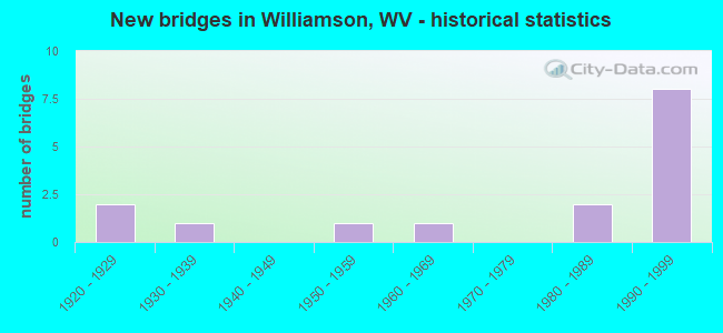
- New bridges - historical statistics
- 21920-1929
- 11930-1939
- 11950-1959
- 11960-1969
- 21980-1989
- 81990-1999


- Bridge Condition - Deck
- 36.4%Satisfactory
- 36.4%Fair
- 27.3%Poor

- Bridge Condition - Superstructure
- 9.1%Good
- 45.5%Satisfactory
- 18.2%Fair
- 27.3%Poor

- Bridge Condition - Substructure
- 9.1%Good
- 27.3%Satisfactory
- 45.5%Fair
- 18.2%Poor

- Bridge Condition - Channel
- 11.1%Very good
- 77.8%Good
- 11.1%Fair
Find on map >> Show street view
Structure Number: 30A065, Location: 0.14 MI EAST OF CR 52/27 (Lat: 37.679431, Lng: -82.295261), Route carried "on" structure: County highway 15, Year Built: 1934, Status: Open, Structure Length: 2.00m (6.56ft), Average Daily Traffic: 3,600 (year 2019), Truck Traffic: 6%, Average Future Daily Traffic: 3,780 (year 2039), Design Load: H 20, Features Intersected: NS RAILROAD
Minimum Vertical Clearance: 30+ m (98+ ft), Kilometerpoint: 2.623, Lanes on structure: 2, Owner: State Highway Agency, Approaching Roadway Width: 8.2m (26.9ft), Skew: 2 degrees, Material/Design: Steel, Design/Construction: Girder and Floorbeam System, Number Of Spans In Main Unit: 1, Length of Maximum Span: 19.2m (63.0ft), Curb or Sidewalk Widths: Left: 0.2m (0.7ft), Right: 1.2m (3.9ft), Curb-To-Curb Width: 7.3m (24.0ft), Out-to-Out Width: 9.1m (29.9ft)
Condition: Deck: Poor, Superstructure: Poor, Substructure: Satisfactory, Operating Rating: 49.0 metric tons, Method Used To Determine Operating Rating: Load Factor (LF), Inventory Rating: 29.0 metric tons, Method Used To Determine Inventory Rating: Load Factor (LF), Structural Evaluation: Meets minimum limits, Deck Geometry: High priority of replacement, Underclear: Somewhat better than minimum adequacy, Approach Roadway Alignment: Equal to present minimum criteria, Length Of Structure Improvement: 2.19m (7.19ft), Designated Inspection Frequency: Every 24 months, Critical Feature Inspection Frequency: Every 12 months, Inspection Date: June 2021, Critical Feature Inspection Date: May 2021, Bridge Improvement Cost: $850,000, Roadway Improvement Cost: $100,000, Total Project Cost: $950,000 ( Estimate for 2018), Deck Structure Type: Concrete Cast-file-Place, Wearing Surface/Protective System: Wearing Surface: Bituminous
Find on map >> Show street view
Structure Number: 30A066, Location: 0.09 MI WEST OF CR 119/1 (Lat: 37.670750, Lng: -82.274900), Route carried "on" structure: US 5200, Year Built: 1992, Status: Posted for load, Structure Length: 13.29m (43.60ft), Average Daily Traffic: 6,534 (year 2020), Truck Traffic: 8%, Average Future Daily Traffic: 7,971 (year 2040), Design Load: HS 25 or greater, Features Intersected: CR 119/1, Facility Carried by Structure: US 52
Minimum Vertical Clearance: 30+ m (98+ ft), Kilometerpoint: 33.780, Lanes on structure: 2, Lanes under structure: 2, Base Highway Network: Yes, Owner: State Highway Agency, Approaching Roadway Width: 8.5m (27.9ft), Material/Design: Prestressed concrete, Design/Construction: Box Beam or Girders - Multiple, Number Of Spans In Main Unit: 1, Number Of Approach Spans: 5, Length of Maximum Span: 25.3m (83.0ft), Curb or Sidewalk Widths: Left: 1.5m (4.9ft), Right: 0.0m, Curb-To-Curb Width: 9.0m (29.5ft), Out-to-Out Width: 11.5m (37.7ft)
Condition: Deck: Poor, Superstructure: Poor, Substructure: Poor, Channel: Very good, Operating Rating: 48.1 metric tons, Method Used To Determine Operating Rating: Load Factor (LF), Inventory Rating: 27.2 metric tons, Method Used To Determine Inventory Rating: Load Factor (LF), Structural Evaluation: Meets minimum limits, Deck Geometry: Meets minimum limits, Underclear: Equal to present minimum criteria, Waterway Adequacy: Superior to present desirable criteria, Approach Roadway Alignment: Equal to present desirable criteria, Designated Inspection Frequency: Every 24 months, Other Special Inspection Frequency: Every 6 months, Inspection Date: November 2020, Other Special Inspection Date: October 2021, Deck Structure Type: Other, Wearing Surface/Protective System: Wearing Surface: Bituminous, Deck Protection: Epoxy Coated Reinforcing
Find on map >> Show street view
Structure Number: 30A109, Location: 0.08 MI EAST OF US 52 (Lat: 37.673131, Lng: -82.279939), Route carried "on" structure: Ramp US 11900, Year Built: 1950, Status: Posted for load, Structure Length: 9.07m (29.76ft), Average Daily Traffic: 8,800 (year 2017), Truck Traffic: 10%, Average Future Daily Traffic: 13,024 (year 2037), Design Load: HS 20, Features Intersected: TUG FORK RIVER, Facility Carried by Structure: US 119 CONNECTOR
Minimum Vertical Clearance: 4.62m (15.16ft), Kilometerpoint: 0.016, Lanes on structure: 2, Owner: State Highway Agency, Approaching Roadway Width: 8.5m (27.9ft), Navigation Control: Yes ( Vertical Clearance: 13.7m (44.9ft), Horizontal Clearance: 61.0m (200.1ft)), Material/Design: Steel, Design/Construction: Truss - Thru, Number Of Spans In Main Unit: 1, Number Of Approach Spans: 2, Length of Maximum Span: 63.4m (208.0ft), Curb or Sidewalk Widths: Left: 1.5m (4.9ft), Right: 1.5m (4.9ft), Curb-To-Curb Width: 8.5m (27.9ft), Out-to-Out Width: 11.9m (39.0ft)
Condition: Deck: Fair, Superstructure: Satisfactory, Substructure: Fair, Channel: Good, Operating Rating: 51.7 metric tons, Method Used To Determine Operating Rating: Load Factor (LF), Inventory Rating: 30.8 metric tons, Method Used To Determine Inventory Rating: Load Factor (LF), Structural Evaluation: Somewhat better than minimum adequacy, Deck Geometry: High priority of corrective action, Waterway Adequacy: Equal to present desirable criteria, Approach Roadway Alignment: Somewhat better than minimum adequacy, Length Of Structure Improvement: 9.14m (29.99ft), Designated Inspection Frequency: Every 24 months, Critical Feature Inspection Frequency: Every 24 months, Inspection Date: January 2020, Critical Feature Inspection Date: January 2020, Bridge Improvement Cost: $378,000, Roadway Improvement Cost: $25,000, Total Project Cost: $663,000 ( Estimate for 2018), Deck Structure Type: Concrete Cast-file-Place, Wearing Surface/Protective System: Wearing Surface: Latex Concrete
Find on map >> Show street view
Structure Number: 30A113, Location: 0.38 MI WEST OF US 119 (Lat: 37.699939, Lng: -82.296019), Route carried "on" structure: County highway 1400, Year Built: 1926, Status: Posted for load, Structure Length: 2.65m (8.69ft), Average Daily Traffic: 1,700 (year 2020), Truck Traffic: 7%, Average Future Daily Traffic: 1,785 (year 2040), Features Intersected: BUFFALO CREEK, Facility Carried by Structure: CR 14
Minimum Vertical Clearance: 30+ m (98+ ft), Kilometerpoint: 0.612, Lanes on structure: 2, Owner: State Highway Agency, Approaching Roadway Width: 6.7m (22.0ft), Material/Design: Concrete, Design/Construction: Tee Beam, Number Of Spans In Main Unit: 2, Number Of Approach Spans: 1, Length of Maximum Span: 8.1m (26.6ft), Curb or Sidewalk Widths: Left: 0.1m (0.3ft), Right: 0.1m (0.3ft), Curb-To-Curb Width: 6.2m (20.3ft), Out-to-Out Width: 6.9m (22.6ft)
Condition: Deck: Poor, Superstructure: Poor, Substructure: Poor, Channel: Good, Operating Rating: 37.2 metric tons, Method Used To Determine Operating Rating: Load Factor (LF), Inventory Rating: 22.7 metric tons, Method Used To Determine Inventory Rating: Load Factor (LF), Structural Evaluation: Meets minimum limits, Deck Geometry: High priority of replacement, Waterway Adequacy: Equal to present minimum criteria, Approach Roadway Alignment: Better than present minimum criteria, Length Of Structure Improvement: 3.05m (10.01ft), Designated Inspection Frequency: Every 24 months, Inspection Date: October 2021, Bridge Improvement Cost: $360,000, Roadway Improvement Cost: $320,000, Total Project Cost: $900,000 ( Estimate for 2017), Deck Structure Type: Concrete Cast-file-Place, Wearing Surface/Protective System: Wearing Surface: Bituminous
Find on map >> Show street view
Structure Number: 30A162, Location: 0.80 MI W OF WV 49 (Lat: 37.661661, Lng: -82.262169), Route carried "on" structure: US 5200, Year Built: 1960, Status: Open, Structure Length: 40.23m (131.99ft), Average Daily Traffic: 4,400 (year 2020), Truck Traffic: 8%, Average Future Daily Traffic: 5,368 (year 2040), Features Intersected: E 4TH AVE HILLSIDE, Facility Carried by Structure: US 52
Minimum Vertical Clearance: 30+ m (98+ ft), Kilometerpoint: 35.679, Lanes on structure: 2, Base Highway Network: Yes, Owner: State Highway Agency, Approaching Roadway Width: 8.5m (27.9ft), Material/Design: Steel continuous, Design/Construction: Stringer/Multi-beam, Number Of Spans In Main Unit: 88, Length of Maximum Span: 4.6m (15.1ft), Curb or Sidewalk Widths: Left: 0.5m (1.6ft), Right: 0.4m (1.3ft), Curb-To-Curb Width: 8.5m (27.9ft), Out-to-Out Width: 9.4m (30.8ft)
Condition: Deck: Fair, Superstructure: Satisfactory, Substructure: Fair, Operating Rating: 88.9 metric tons, Method Used To Determine Operating Rating: Load Factor (LF), Inventory Rating: 55.3 metric tons, Method Used To Determine Inventory Rating: Load Factor (LF), Structural Evaluation: Somewhat better than minimum adequacy, Deck Geometry: Meets minimum limits, Approach Roadway Alignment: Better than present minimum criteria, Designated Inspection Frequency: Every 24 months, Critical Feature Inspection Frequency: Every 24 months, Inspection Date: November 2021, Critical Feature Inspection Date: November 2021, Deck Structure Type: Concrete Cast-file-Place, Wearing Surface/Protective System: Wearing Surface: Bituminous
Find on map >> Show street view
Structure Number: 30A183, Location: 0.01 Mile South Jct US 52 (Lat: 37.676111, Lng: -82.283611), Route carried "on" structure: US 119, Year Built: 1981, Status: Open, Structure Length: 16.31m (53.51ft), Average Daily Traffic: 11,024 (year 2016), Truck Traffic: 11%, Average Future Daily Traffic: 19,912 (year 2031), Design Load: HS 20, Features Intersected: N&S Railroad, Tug Fork
Minimum Vertical Clearance: 30+ m (98+ ft), Kilometerpoint: 0.016, Lanes on structure: 4, Owner: State Highway Agency, Approaching Roadway Width: 26.8m (87.9ft), Skew: 21 degrees, Material/Design: Steel continuous, Design/Construction: Stringer/Multi-beam, Number Of Spans In Main Unit: 3, Number Of Approach Spans: 2, Length of Maximum Span: 48.8m (160.1ft), Curb-To-Curb Width: 26.5m (86.9ft), Out-to-Out Width: 27.5m (90.2ft)
Condition: Deck: Fair, Superstructure: Satisfactory, Substructure: Fair, Channel: Good, Operating Rating: 57.5 metric tons, Method Used To Determine Operating Rating: Load Factor (LF), Inventory Rating: 34.5 metric tons, Method Used To Determine Inventory Rating: Load Factor (LF), Structural Evaluation: Somewhat better than minimum adequacy, Deck Geometry: Superior to present desirable criteria, Waterway Adequacy: Equal to present desirable criteria, Approach Roadway Alignment: Equal to present desirable criteria, Length Of Structure Improvement: 1.54m (5.05ft), Designated Inspection Frequency: Every 24 months, Inspection Date: January 2022, Bridge Improvement Cost: $5,718,000, Total Project Cost: $5,718,000, Deck Structure Type: Concrete Cast-file-Place, Wearing Surface/Protective System: Wearing Surface: Monolithic Concrete, Deck Protection: Epoxy Coated Reinforcing
Find on map >> Show street view
Structure Number: 30A187, Location: 0.01 MILE WEST OF US 52 (Lat: 37.697931, Lng: -82.300119), Route carried "on" structure: US 5200, Year Built: 1996, Status: Open, Structure Length: 31.50m (103.35ft), Average Daily Traffic: 9,300 (year 2018), Truck Traffic: 10%, Average Future Daily Traffic: 13,764 (year 2038), Design Load: HS 25 or greater, Features Intersected: KY Rt. 292 and Tug Fork, Facility Carried by Structure: US 52
Minimum Vertical Clearance: 30+ m (98+ ft), Kilometerpoint: 29.306, Lanes on structure: 4, Lanes under structure: 2, Base Highway Network: Yes, Owner: State Highway Agency, Approaching Roadway Width: 28.3m (92.8ft), Skew: 25 degrees, Navigation Control: Yes ( Vertical Clearance: 14.6m (47.9ft), Horizontal Clearance: 65.5m (214.9ft)), Material/Design: Steel continuous, Design/Construction: Stringer/Multi-beam, Number Of Spans In Main Unit: 1, Number Of Approach Spans: 7, Length of Maximum Span: 67.1m (220.1ft), Curb-To-Curb Width: 27.4m (89.9ft), Out-to-Out Width: 28.5m (93.5ft)
Condition: Deck: Satisfactory, Superstructure: Good, Substructure: Good, Channel: Good, Operating Rating: 60.8 metric tons, Method Used To Determine Operating Rating: Load Factor (LF), Inventory Rating: 36.3 metric tons, Method Used To Determine Inventory Rating: Load Factor (LF), Structural Evaluation: Better than present minimum criteria, Deck Geometry: Superior to present desirable criteria, Underclear: High priority of corrective action, Waterway Adequacy: Equal to present desirable criteria, Approach Roadway Alignment: Equal to present desirable criteria, Designated Inspection Frequency: Every 24 months, Inspection Date: October 2020, Deck Structure Type: Concrete Cast-file-Place, Wearing Surface/Protective System: Wearing Surface: Monolithic Concrete, Deck Protection: Epoxy Coated Reinforcing
Find on map >> Show street view
Structure Number: 30A196, Location: 0.01 MILE EAST OF KY 292 (Lat: 37.684739, Lng: -82.296650), Route carried "on" structure: US 5200, Year Built: 1996, Status: Open, Structure Length: 35.62m (116.86ft), Average Daily Traffic: 7,300 (year 2020), Truck Traffic: 8%, Average Future Daily Traffic: 8,906 (year 2040), Design Load: HS 25 or greater, Features Intersected: TUG FORK, CO 15, NSRR, Facility Carried by Structure: US 52
Minimum Vertical Clearance: 30+ m (98+ ft), Kilometerpoint: 30.980, Lanes on structure: 2, Lanes under structure: 2, Base Highway Network: Yes, Owner: State Highway Agency, Approaching Roadway Width: 12.2m (40.0ft), Skew: 20 degrees, Navigation Control: Yes ( Vertical Clearance: 13.7m (44.9ft), Horizontal Clearance: 30.5m (100.1ft)), Material/Design: Prestressed concrete continuous, Design/Construction: Stringer/Multi-beam, Number Of Spans In Main Unit: 4, Number Of Approach Spans: 4, Length of Maximum Span: 48.5m (159.1ft), Curb-To-Curb Width: 12.2m (40.0ft), Out-to-Out Width: 15.5m (50.9ft)
Condition: Deck: Satisfactory, Superstructure: Fair, Substructure: Fair, Channel: Good, Operating Rating: 37.2 metric tons, Method Used To Determine Operating Rating: Load Factor (LF), Inventory Rating: 10.9 metric tons, Method Used To Determine Inventory Rating: Load Factor (LF), Structural Evaluation: High priority of corrective action, Deck Geometry: Somewhat better than minimum adequacy, Underclear: Somewhat better than minimum adequacy, Waterway Adequacy: Better than present minimum criteria, Approach Roadway Alignment: Better than present minimum criteria, Designated Inspection Frequency: Every 24 months, Underwater Inspection Frequency: Every 60 months, Other Special Inspection Frequency: Every 12 months, Inspection Date: November 2021, Underwater Inspection Date: October 2018, Other Special Inspection Date: November 2021, Deck Structure Type: Concrete Cast-file-Place, Wearing Surface/Protective System: Wearing Surface: Integral Concrete, Membrane: Epoxy, Deck Protection: Epoxy Coated Reinforcing
Find on map >> Show street view
Structure Number: 30A197, Location: 0.01 MILE SOUTH OF KY 292 (Lat: 37.687569, Lng: -82.297119), Route carried "on" structure: US 5200, Year Built: 1997, Status: Open, Structure Length: 13.72m (45.01ft), Average Daily Traffic: 9,800 (year 2019), Truck Traffic: 8%, Average Future Daily Traffic: 11,956 (year 2039), Design Load: HS 25 or greater, Features Intersected: TUG FORK RIVER, Facility Carried by Structure: US 52
Minimum Vertical Clearance: 30+ m (98+ ft), Kilometerpoint: 30.722, Lanes on structure: 4, Base Highway Network: Yes, Owner: State Highway Agency, Approaching Roadway Width: 28.3m (92.8ft), Skew: 2 degrees, Navigation Control: Yes ( Vertical Clearance: 13.7m (44.9ft), Horizontal Clearance: 30.5m (100.1ft)), Material/Design: Prestressed concrete continuous, Design/Construction: Stringer/Multi-beam, Number Of Spans In Main Unit: 2, Number Of Approach Spans: 2, Length of Maximum Span: 34.6m (113.5ft), Curb or Sidewalk Widths: Left: 0.5m (1.6ft), Right: 0.5m (1.6ft), Curb-To-Curb Width: 27.4m (89.9ft), Out-to-Out Width: 28.5m (93.5ft)
Condition: Deck: Satisfactory, Superstructure: Satisfactory, Substructure: Satisfactory, Channel: Fair, Operating Rating: 77.1 metric tons, Method Used To Determine Operating Rating: Load Factor (LF), Inventory Rating: 42.6 metric tons, Method Used To Determine Inventory Rating: Load Factor (LF), Structural Evaluation: Equal to present minimum criteria, Deck Geometry: Superior to present desirable criteria, Waterway Adequacy: Equal to present desirable criteria, Approach Roadway Alignment: Equal to present desirable criteria, Designated Inspection Frequency: Every 24 months, Inspection Date: June 2021, Deck Structure Type: Concrete Cast-file-Place, Wearing Surface/Protective System: Wearing Surface: Monolithic Concrete, Membrane: Epoxy, Deck Protection: Epoxy Coated Reinforcing
Find on map >> Show street view
Structure Number: 30A279, Location: KY State Line (Lat: 37.669439, Lng: -82.276389), Route carried "on" structure: Alternate US 119, Year Built: 1981, Status: Open, Structure Length: 10.79m (35.40ft), Average Daily Traffic: 7,076 (year 2016), Truck Traffic: 7%, Average Future Daily Traffic: 11,407 (year 2036), Design Load: HS 20, Features Intersected: Tug Fork River
Minimum Vertical Clearance: 30+ m (98+ ft), Kilometerpoint: 0.016, Lanes on structure: 2, Owner: State Highway Agency, Approaching Roadway Width: 98.1m (321.9ft), Skew: 4 degrees, Material/Design: Steel continuous, Design/Construction: Stringer/Multi-beam, Number Of Spans In Main Unit: 3, Length of Maximum Span: 45.7m (149.9ft), Curb or Sidewalk Widths: Left: 1.5m (4.9ft), Right: 0.5m (1.6ft), Curb-To-Curb Width: 9.8m (32.2ft), Out-to-Out Width: 10.7m (35.1ft)
Condition: Deck: Satisfactory, Superstructure: Satisfactory, Substructure: Satisfactory, Channel: Good, Operating Rating: 86.9 metric tons, Method Used To Determine Operating Rating: Load Factor (LF), Inventory Rating: 52.2 metric tons, Method Used To Determine Inventory Rating: Load Factor (LF), Structural Evaluation: Equal to present minimum criteria, Deck Geometry: Meets minimum limits, Waterway Adequacy: Equal to present desirable criteria, Approach Roadway Alignment: Equal to present minimum criteria, Designated Inspection Frequency: Every 24 months, Inspection Date: January 2022, Deck Structure Type: Concrete Cast-file-Place
Find on map >> Show street view
Structure Number: 30A282, Location: 0.01 MILE SOUTH OF KY 292 (Lat: 37.684750, Lng: -82.296561), Route carried "on" structure: US 5200, Year Built: 1996, Status: Open, Structure Length: 34.61m (113.55ft), Average Daily Traffic: 7,300 (year 2020), Truck Traffic: 8%, Average Future Daily Traffic: 8,906 (year 2040), Design Load: HS 25 or greater, Features Intersected: TUG FORK, CO 15, NSRR, Facility Carried by Structure: US 52
Minimum Vertical Clearance: 30+ m (98+ ft), Kilometerpoint: 30.980, Lanes on structure: 2, Lanes under structure: 2, Base Highway Network: Yes, Owner: State Highway Agency, Approaching Roadway Width: 12.2m (40.0ft), Skew: 20 degrees, Material/Design: Prestressed concrete continuous, Design/Construction: Stringer/Multi-beam, Number Of Spans In Main Unit: 4, Number Of Approach Spans: 4, Length of Maximum Span: 48.5m (159.1ft), Curb-To-Curb Width: 12.2m (40.0ft), Out-to-Out Width: 15.5m (50.9ft)
Condition: Deck: Fair, Superstructure: Fair, Substructure: Fair, Channel: Good, Operating Rating: 40.8 metric tons, Method Used To Determine Operating Rating: Load Factor (LF), Inventory Rating: 24.5 metric tons, Method Used To Determine Inventory Rating: Load Factor (LF), Structural Evaluation: Somewhat better than minimum adequacy, Deck Geometry: Better than present minimum criteria, Underclear: Superior to present desirable criteria, Waterway Adequacy: Better than present minimum criteria, Approach Roadway Alignment: Better than present minimum criteria, Designated Inspection Frequency: Every 24 months, Underwater Inspection Frequency: Every 60 months, Inspection Date: November 2021, Underwater Inspection Date: October 2018, Deck Structure Type: Concrete Cast-file-Place, Wearing Surface/Protective System: Wearing Surface: Integral Concrete, Membrane: Epoxy
Find on map >> Show street view
Structure Number: 30A066, Location: 0.09 MI WEST OF CR 119/1 (Lat: 37.671011, Lng: -82.275150), Route carried "under" structure: County highway 11901, Year Built: 1992, Structure Length: 0. m, Average Daily Traffic: 1,200 (year 0007), Truck Traffic: 7%, Features Intersected: CR 119/1, Facility Carried by Structure: US 52
Minimum Vertical Clearance: 9.14m (29.99ft), Kilometerpoint: 0.145, Lanes on structure: 2, Lanes under structure: 2, Length of Maximum Span: 25.3m (83.0ft)
Find on map >> Show street view
Structure Number: 30A103, Location: 0.02 MI WEST OF US 52 (Lat: 37.674150, Lng: -82.277569), Route carried "under" structure: Ramp US 11900, Year Built: 1926, Structure Length: 0. m, Average Daily Traffic: 8,800 (year 2010), Truck Traffic: 10%, Features Intersected: US ROUTE 119C, Facility Carried by Structure: NS RAILROAD
Minimum Vertical Clearance: 4.09m (13.42ft), Kilometerpoint: 0.257, Lanes under structure: 2, Length of Maximum Span: 12.6m (41.3ft)
Find on map >> Show street view
Structure Number: 30A187, Location: 0.01 MILE WEST OF US 52 (Lat: 37.697931, Lng: -82.300119), Route carried "under" structure: State highway 29200, Year Built: 1996, Structure Length: 0. m, Average Daily Traffic: 2,000 (year 0007), Truck Traffic: 14%, Features Intersected: KY Rt. 292 and Tug Fork, Facility Carried by Structure: US 52
Minimum Vertical Clearance: 6.63m (21.75ft), Kilometerpoint: 0.000, Lanes on structure: 4, Lanes under structure: 2, Length of Maximum Span: 67.1m (220.1ft)
Find on map >> Show street view
Structure Number: 30A196, Location: 0.01 MILE EAST OF KY 292 (Lat: 37.684739, Lng: -82.296650), Route carried "under" structure: County highway 150, Year Built: 1996, Structure Length: 0. m, Average Daily Traffic: 4,000 (year 0007), Truck Traffic: 6%, Features Intersected: TUG FORK, CO 15, NSRR, Facility Carried by Structure: US 52
Minimum Vertical Clearance: 10.67m (35.01ft), Kilometerpoint: 2.623, Lanes on structure: 2, Lanes under structure: 2, Length of Maximum Span: 48.5m (159.1ft)