Bridge Statistics for Willards, Maryland (MD)
Condition, Traffic, Stress, Structural Evaluation, Project Costs
- National Bridge Inventory (NBI) Statistics
- 10Number of bridges
- 72ft / 21.9mTotal length
- $641,000Total costs
- 104,326Total average daily traffic
- 8,248Total average daily truck traffic
- 139,192Total future (year 2026) average daily traffic
- National Bridge Inventory (NBI) Registered Bridges for Willards
- No street view available for this location
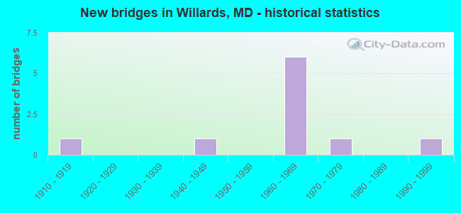
- New bridges - historical statistics
- 11910-1919
- 11940-1949
- 61960-1969
- 11970-1979
- 11990-1999


- Bridge Condition - Deck
- 12.5%Good
- 62.5%Satisfactory
- 25.0%Fair

- Bridge Condition - Superstructure
- 25.0%Good
- 50.0%Satisfactory
- 25.0%Fair

- Bridge Condition - Substructure
- 12.5%Good
- 50.0%Satisfactory
- 25.0%Fair
- 12.5%Poor

- Bridge Condition - Channel
- 10.0%Very good
- 30.0%Good
- 50.0%Satisfactory
- 10.0%Fair
Find on map >> Show street view
Structure Number: 100000220001013, Location: ON WORCESTER CO LINE (Lat: 38.384342, Lng: -75.327111), Route carried "on" structure: US 50, Year Built: 1964, Status: Open, Structure Length: 3.05m (10.01ft), Average Daily Traffic: 24,122 (year 2009), Truck Traffic: 8%, Average Future Daily Traffic: 32,362 (year 2029), Design Load: HS 20, Features Intersected: POCOMOKE RIVER
Minimum Vertical Clearance: 30+ m (98+ ft), Kilometerpoint: 49.388, Lanes on structure: 2, Base Highway Network: Yes, Owner: State Highway Agency, Approaching Roadway Width: 11.3m (37.1ft), Skew: 2 degrees, Material/Design: Steel, Design/Construction: Stringer/Multi-beam, Number Of Spans In Main Unit: 3, Length of Maximum Span: 10.1m (33.1ft), Curb-To-Curb Width: 11.7m (38.4ft), Out-to-Out Width: 12.3m (40.4ft)
Condition: Deck: Satisfactory, Superstructure: Fair, Substructure: Satisfactory, Channel: Satisfactory, Operating Rating: 62.6 metric tons, Method Used To Determine Operating Rating: Load Factor (LF), Inventory Rating: 37.2 metric tons, Method Used To Determine Inventory Rating: Load Factor (LF), Structural Evaluation: Somewhat better than minimum adequacy, Deck Geometry: Better than present minimum criteria, Waterway Adequacy: Superior to present desirable criteria, Approach Roadway Alignment: Equal to present desirable criteria, Designated Inspection Frequency: Every 12 months, Inspection Date: June 2021, Deck Structure Type: Concrete Cast-file-Place, Wearing Surface/Protective System: Wearing Surface: Bituminous
Find on map >> Show street view
Structure Number: 100000220001014, Location: ON WORCESTER CO LINE (Lat: 38.384928, Lng: -75.326394), Route carried "on" structure: US 50, Year Built: 1964, Status: Open, Structure Length: 3.05m (10.01ft), Average Daily Traffic: 24,122 (year 2009), Truck Traffic: 8%, Average Future Daily Traffic: 32,362 (year 2029), Design Load: HS 20, Features Intersected: POCOMOKE RIVER
Minimum Vertical Clearance: 30+ m (98+ ft), Kilometerpoint: 49.388, Lanes on structure: 2, Base Highway Network: Yes, Owner: State Highway Agency, Approaching Roadway Width: 11.9m (39.0ft), Skew: 2 degrees, Material/Design: Steel, Design/Construction: Stringer/Multi-beam, Number Of Spans In Main Unit: 3, Length of Maximum Span: 10.1m (33.1ft), Curb-To-Curb Width: 11.7m (38.4ft), Out-to-Out Width: 12.3m (40.4ft)
Condition: Deck: Satisfactory, Superstructure: Satisfactory, Substructure: Satisfactory, Channel: Good, Operating Rating: 62.6 metric tons, Method Used To Determine Operating Rating: Load Factor (LF), Inventory Rating: 37.2 metric tons, Method Used To Determine Inventory Rating: Load Factor (LF), Structural Evaluation: Equal to present minimum criteria, Deck Geometry: Better than present minimum criteria, Waterway Adequacy: Superior to present desirable criteria, Approach Roadway Alignment: Equal to present desirable criteria, Designated Inspection Frequency: Every 24 months, Inspection Date: June 2020, Deck Structure Type: Concrete Cast-file-Place, Wearing Surface/Protective System: Wearing Surface: Bituminous
Find on map >> Show street view
Structure Number: 10000022001001, Location: 0.73 MI W OF WORCESTER CO (Lat: 38.388925, Lng: -75.337886), Route carried "on" structure: State highway 346, Year Built: 1919, Year Reconstructed: 1953, Status: Open, Structure Length: 0.91m (2.99ft), Average Daily Traffic: 2,382 (year 2009), Truck Traffic: 8%, Average Future Daily Traffic: 2,919 (year 2026), Design Load: H 20, Features Intersected: BURNT MILL BRANCH
Minimum Vertical Clearance: 30+ m (98+ ft), Kilometerpoint: 22.092, Lanes on structure: 2, Owner: State Highway Agency, Approaching Roadway Width: 10.4m (34.1ft), Material/Design: Concrete, Design/Construction: Slab, Number Of Spans In Main Unit: 2, Length of Maximum Span: 4.6m (15.1ft), Curb-To-Curb Width: 12.2m (40.0ft), Out-to-Out Width: 12.2m (40.0ft)
Condition: Deck: Fair, Superstructure: Good, Substructure: Good, Channel: Good, Operating Rating: 64.4 metric tons, Method Used To Determine Operating Rating: Load Factor (LF), Inventory Rating: 38.5 metric tons, Method Used To Determine Inventory Rating: Load Factor (LF), Structural Evaluation: Better than present minimum criteria, Deck Geometry: Equal to present minimum criteria, Waterway Adequacy: Superior to present desirable criteria, Approach Roadway Alignment: Equal to present desirable criteria, Designated Inspection Frequency: Every 24 months, Inspection Date: May 2021, Deck Structure Type: Concrete Cast-file-Place, Wearing Surface/Protective System: Wearing Surface: Bituminous
Find on map >> Show street view
Structure Number: 10000022001101, Location: ON WORCESTER CO LINE (Lat: 38.389136, Lng: -75.324653), Route carried "on" structure: State highway 346, Year Built: 1946, Status: Open, Structure Length: 3.14m (10.30ft), Average Daily Traffic: 2,382 (year 2009), Truck Traffic: 8%, Average Future Daily Traffic: 2,919 (year 2026), Design Load: H 20, Features Intersected: POCOMOKE RIVER
Minimum Vertical Clearance: 30+ m (98+ ft), Kilometerpoint: 23.266, Lanes on structure: 2, Owner: State Highway Agency, Approaching Roadway Width: 7.3m (24.0ft), Skew: 3 degrees, Material/Design: Concrete, Design/Construction: Tee Beam, Number Of Spans In Main Unit: 3, Length of Maximum Span: 10.4m (34.1ft), Curb or Sidewalk Widths: Left: 0.9m (3.0ft), Right: 0.9m (3.0ft), Curb-To-Curb Width: 8.5m (27.9ft), Out-to-Out Width: 11.2m (36.7ft)
Condition: Deck: Fair, Superstructure: Fair, Substructure: Satisfactory, Channel: Satisfactory, Operating Rating: 44.0 metric tons, Method Used To Determine Operating Rating: Load Factor (LF), Inventory Rating: 26.3 metric tons, Method Used To Determine Inventory Rating: Load Factor (LF), Structural Evaluation: Somewhat better than minimum adequacy, Deck Geometry: Meets minimum limits, Waterway Adequacy: Superior to present desirable criteria, Approach Roadway Alignment: Equal to present desirable criteria, Designated Inspection Frequency: Every 12 months, Inspection Date: May 2021, Deck Structure Type: Concrete Cast-file-Place, Wearing Surface/Protective System: Wearing Surface: Bituminous
Find on map >> Show street view
Structure Number: 100000220030023, Location: 0.50 MI W OF WORCESTER CO (Lat: 38.384167, Lng: -75.336111), Route carried "on" structure: US 50, Year Built: 1964, Status: Open, Structure Length: 1.34m (4.40ft), Average Daily Traffic: 24,122 (year 2009), Truck Traffic: 8%, Average Future Daily Traffic: 32,362 (year 2029), Design Load: HS 20, Features Intersected: BURNT MILL BRANCH
Minimum Vertical Clearance: 30+ m (98+ ft), Kilometerpoint: 48.584, Lanes on structure: 2, Base Highway Network: Yes, Owner: State Highway Agency, Approaching Roadway Width: 11.3m (37.1ft), Skew: 2 degrees, Material/Design: Concrete, Design/Construction: Culvert, Length of Maximum Span: 4.6m (15.1ft)
Condition: Channel: Satisfactory, Culverts: Satisfactory, Operating Rating: 32.7 metric tons, Method Used To Determine Operating Rating: Field evaluation and documented engineering judgment, Inventory Rating: 32.7 metric tons, Method Used To Determine Inventory Rating: Field evaluation and documented engineering judgment, Structural Evaluation: Equal to present minimum criteria, Waterway Adequacy: Equal to present desirable criteria, Approach Roadway Alignment: Equal to present desirable criteria, Designated Inspection Frequency: Every 24 months, Inspection Date: April 2020
Find on map >> Show street view
Structure Number: 100000220030024, Location: 0.50 MI W OF WORCESTER CO (Lat: 38.384728, Lng: -75.336172), Route carried "on" structure: US 50, Year Built: 1964, Status: Open, Structure Length: 1.34m (4.40ft), Average Daily Traffic: 24,122 (year 2009), Truck Traffic: 8%, Average Future Daily Traffic: 32,362 (year 2029), Design Load: HS 20, Features Intersected: BURNT MILL BRANCH
Minimum Vertical Clearance: 30+ m (98+ ft), Kilometerpoint: 48.584, Lanes on structure: 2, Base Highway Network: Yes, Owner: State Highway Agency, Approaching Roadway Width: 11.3m (37.1ft), Skew: 2 degrees, Material/Design: Concrete, Design/Construction: Culvert, Length of Maximum Span: 4.6m (15.1ft)
Condition: Channel: Satisfactory, Culverts: Satisfactory, Operating Rating: 32.7 metric tons, Method Used To Determine Operating Rating: Field evaluation and documented engineering judgment, Inventory Rating: 32.7 metric tons, Method Used To Determine Inventory Rating: Field evaluation and documented engineering judgment, Structural Evaluation: Equal to present minimum criteria, Waterway Adequacy: Equal to present desirable criteria, Approach Roadway Alignment: Equal to present desirable criteria, Designated Inspection Frequency: Every 24 months, Inspection Date: April 2020
Find on map >> Show street view
Structure Number: 200000WI123101, Location: 0.5 MI E OF MD RTE 94 (Lat: 38.396683, Lng: -75.341808), Route carried "on" structure: County highway 369, Year Built: 1967, Status: Open, Structure Length: 2.10m (6.89ft), Average Daily Traffic: 888 (year 2021), Truck Traffic: 5%, Average Future Daily Traffic: 1,097 (year 2043), Design Load: H 20, Features Intersected: BURNT MILL BRANCH, Facility Carried by Structure: THREE BRIDGES ROAD
Minimum Vertical Clearance: 30+ m (98+ ft), Kilometerpoint: 0.805, Lanes on structure: 2, Base Highway Network: Yes, Owner: County Highway Agency, Approaching Roadway Width: 7.3m (24.0ft), Material/Design: Wood or Timber, Design/Construction: Slab, Number Of Spans In Main Unit: 4, Length of Maximum Span: 5.2m (17.1ft), Curb or Sidewalk Widths: Left: 0.1m (0.3ft), Right: 0.1m (0.3ft), Curb-To-Curb Width: 8.9m (29.2ft), Out-to-Out Width: 9.8m (32.2ft)
Condition: Deck: Satisfactory, Superstructure: Satisfactory, Substructure: Poor, Channel: Satisfactory, Inventory Rating: 84.8 metric tons, Method Used To Determine Inventory Rating: Allowable Stress (AS), Structural Evaluation: Meets minimum limits, Deck Geometry: Somewhat better than minimum adequacy, Waterway Adequacy: Better than present minimum criteria, Approach Roadway Alignment: Equal to present desirable criteria, Designated Inspection Frequency: Every 12 months, Inspection Date: November 2021, Deck Structure Type: Concrete Cast-file-Place, Wearing Surface/Protective System: Wearing Surface: Monolithic Concrete
Find on map >> Show street view
Structure Number: 200000WI151101, Location: 0.75 MI E BETHEL RD (Lat: 38.440981, Lng: -75.336814), Route carried "on" structure: County highway 377, Year Built: 1994, Status: Open, Structure Length: 3.17m (10.40ft), Average Daily Traffic: 370 (year 2021), Truck Traffic: 5%, Average Future Daily Traffic: 461 (year 2043), Features Intersected: POCOMOKE RIVER, Facility Carried by Structure: SHEPPARDS CROSSING
Minimum Vertical Clearance: 30+ m (98+ ft), Kilometerpoint: 1.126, Lanes on structure: 2, Owner: County Highway Agency, Approaching Roadway Width: 6.7m (22.0ft), Skew: 1 degrees, Material/Design: Wood or Timber, Design/Construction: Slab, Number Of Spans In Main Unit: 5, Length of Maximum Span: 6.1m (20.0ft), Curb or Sidewalk Widths: Left: 0.2m (0.7ft), Right: 0.2m (0.7ft), Curb-To-Curb Width: 6.9m (22.6ft), Out-to-Out Width: 7.2m (23.6ft)
Condition: Deck: Satisfactory, Superstructure: Satisfactory, Substructure: Fair, Channel: Fair, Inventory Rating: 71.7 metric tons, Method Used To Determine Inventory Rating: Allowable Stress (AS), Structural Evaluation: Somewhat better than minimum adequacy, Deck Geometry: Meets minimum limits, Waterway Adequacy: Better than present minimum criteria, Approach Roadway Alignment: Equal to present desirable criteria, Designated Inspection Frequency: Every 24 months, Inspection Date: November 2021, Deck Structure Type: Wood or Timber, Wearing Surface/Protective System: Wearing Surface: Bituminous
Find on map >> Show street view
Structure Number: 200000WI160101, Location: 0.84 MI N OF MD 346 (Lat: 38.400103, Lng: -75.372775), Route carried "on" structure: County highway 349, Year Built: 1974, Status: Open, Structure Length: 1.92m (6.30ft), Average Daily Traffic: 949 (year 2020), Truck Traffic: 5%, Average Future Daily Traffic: 1,265 (year 2042), Design Load: H 20, Features Intersected: BURNT MILL BRANCH, Facility Carried by Structure: RICHARDSON ROAD
Minimum Vertical Clearance: 30+ m (98+ ft), Kilometerpoint: 1.352, Lanes on structure: 2, Owner: County Highway Agency, Approaching Roadway Width: 7.3m (24.0ft), Material/Design: Prestressed concrete, Design/Construction: Box Beam or Girders - Multiple, Number Of Spans In Main Unit: 1, Length of Maximum Span: 18.3m (60.0ft), Curb-To-Curb Width: 9.1m (29.9ft), Out-to-Out Width: 9.8m (32.2ft)
Condition: Deck: Good, Superstructure: Good, Substructure: Satisfactory, Channel: Very good, Operating Rating: 62.1 metric tons, Method Used To Determine Operating Rating: Allowable Stress (AS), Inventory Rating: 37.2 metric tons, Method Used To Determine Inventory Rating: Allowable Stress (AS), Structural Evaluation: Equal to present minimum criteria, Deck Geometry: Equal to present minimum criteria, Waterway Adequacy: Better than present minimum criteria, Approach Roadway Alignment: Better than present minimum criteria, Length Of Structure Improvement: 1.98m (6.50ft), Designated Inspection Frequency: Every 24 months, Inspection Date: October 2020, Bridge Improvement Cost: $243,000, Roadway Improvement Cost: $24,000, Total Project Cost: $267,000, Deck Structure Type: Concrete Precast Panels, Wearing Surface/Protective System: Wearing Surface: Bituminous
Find on map >> Show street view
Structure Number: 200000WI166101, Location: 600 FT N POPLAR NECK RD (Lat: 38.402425, Lng: -75.357611), Route carried "on" structure: County highway 350, Year Built: 1967, Status: Open, Structure Length: 1.89m (6.20ft), Average Daily Traffic: 867 (year 2021), Truck Traffic: 5%, Average Future Daily Traffic: 1,083 (year 2043), Design Load: H 20, Features Intersected: BURNT MILL BRANCH, Facility Carried by Structure: BETHEL ROAD
Minimum Vertical Clearance: 30+ m (98+ ft), Kilometerpoint: 9.751, Lanes on structure: 2, Owner: County Highway Agency, Approaching Roadway Width: 7.0m (23.0ft), Material/Design: Wood or Timber, Design/Construction: Slab, Number Of Spans In Main Unit: 3, Length of Maximum Span: 6.1m (20.0ft), Curb or Sidewalk Widths: Left: 0.2m (0.7ft), Right: 0.2m (0.7ft), Curb-To-Curb Width: 10.1m (33.1ft), Out-to-Out Width: 11.0m (36.1ft)
Condition: Deck: Satisfactory, Superstructure: Satisfactory, Substructure: Fair, Channel: Good, Inventory Rating: 82.1 metric tons, Method Used To Determine Inventory Rating: Allowable Stress (AS), Structural Evaluation: Somewhat better than minimum adequacy, Deck Geometry: Equal to present minimum criteria, Waterway Adequacy: Better than present minimum criteria, Approach Roadway Alignment: Equal to present desirable criteria, Length Of Structure Improvement: 1.89m (6.20ft), Designated Inspection Frequency: Every 24 months, Inspection Date: November 2021, Bridge Improvement Cost: $340,000, Roadway Improvement Cost: $34,000, Total Project Cost: $374,000, Deck Structure Type: Concrete Cast-file-Place, Wearing Surface/Protective System: Wearing Surface: Monolithic Concrete