Bridge Statistics for Willamina, Oregon (OR)
Condition, Traffic, Stress, Structural Evaluation, Project Costs
- National Bridge Inventory (NBI) Statistics
- 13Number of bridges
- 190ft / 57.9mTotal length
- $2,403,000Total costs
- 48,959Total average daily traffic
- 6,496Total average daily truck traffic
- National Bridge Inventory (NBI) Registered Bridges for Willamina
- No street view available for this location
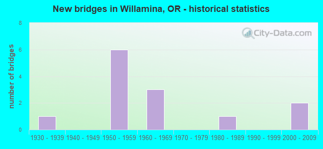
- New bridges - historical statistics
- 11930-1939
- 61950-1959
- 31960-1969
- 11980-1989
- 22000-2009

- Reconstructed bridges - Historical Statistics
- 11960-1969
- 01970-1979
- 11980-1989


- Bridge Condition - Deck
- 10.0%Very good
- 60.0%Good
- 20.0%Satisfactory
- 10.0%Fair

- Bridge Condition - Superstructure
- 10.0%Very good
- 40.0%Good
- 30.0%Satisfactory
- 10.0%Fair
- 10.0%Poor

- Bridge Condition - Substructure
- 10.0%Very good
- 20.0%Good
- 60.0%Satisfactory
- 10.0%Fair

- Bridge Condition - Channel
- 10.0%Very good
- 80.0%Good
- 10.0%Fair
Find on map >> Show street view
Structure Number: 937A157 00225, Location: IN WILLAMINA (Lat: 45.077931, Lng: -123.486664), Route carried "on" structure: Business State highway 213, Year Built: 1963, Status: Open, Structure Length: 4.85m (15.91ft), Average Daily Traffic: 5,057 (year 2020), Truck Traffic: 20%, Average Future Daily Traffic: 5,800 (year 2040), Design Load: HS 20, Features Intersected: Willamina River, Facility Carried by Structure: OR 18 BUS (Hwy157)
Minimum Vertical Clearance: 30+ m (98+ ft), Kilometerpoint: 3.621, Lanes on structure: 2, Owner: State Highway Agency, Approaching Roadway Width: 9.1m (29.9ft), Material/Design: Concrete continuous, Design/Construction: Box Beam or Girders - Multiple, Number Of Spans In Main Unit: 3, Length of Maximum Span: 22.9m (75.1ft), Curb or Sidewalk Widths: Left: 1.5m (4.9ft), Right: 1.5m (4.9ft), Curb-To-Curb Width: 9.1m (29.9ft), Out-to-Out Width: 12.8m (42.0ft)
Condition: Deck: Good, Superstructure: Satisfactory, Substructure: Fair, Channel: Good, Operating Rating: 39.9 metric tons, Method Used To Determine Operating Rating: Load and Resistance Factor Rating (LRFR) rating reported by rating factor(RF) method using HL-93 loadings, Inventory Rating: 30.8 metric tons, Method Used To Determine Inventory Rating: Load and Resistance Factor Rating (LRFR) rating reported by rating factor(RF) method using HL-93 loadings, Structural Evaluation: Somewhat better than minimum adequacy, Deck Geometry: High priority of corrective action, Waterway Adequacy: Equal to present desirable criteria, Approach Roadway Alignment: Equal to present desirable criteria, Length Of Structure Improvement: 4.80m (15.75ft), Designated Inspection Frequency: Every 24 months, Inspection Date: March 2020, Bridge Improvement Cost: $509,000, Roadway Improvement Cost: $51,000, Total Project Cost: $815,000, Deck Structure Type: Concrete Cast-file-Place, Wearing Surface/Protective System: Wearing Surface: Bituminous
Find on map >> Show street view
Structure Number: 2081 030 00003, Location: 247 MI W SALEM (Lat: 45.055561, Lng: -123.492861), Route carried "on" structure: State highway 22, Year Built: 1935, Status: Open, Structure Length: 5.79m (19.00ft), Average Daily Traffic: 3,812 (year 2020), Truck Traffic: 21%, Average Future Daily Traffic: 5,900 (year 2040), Design Load: H 15, Features Intersected: S Yamhill River
Minimum Vertical Clearance: 30+ m (98+ ft), Kilometerpoint: 0.048, Lanes on structure: 1, Base Highway Network: Yes, Owner: State Highway Agency, Approaching Roadway Width: 7.3m (24.0ft), Material/Design: Steel continuous, Design/Construction: Stringer/Multi-beam, Number Of Spans In Main Unit: 3, Length of Maximum Span: 30.5m (100.1ft), Curb or Sidewalk Widths: Left: 1.1m (3.6ft), Right: 1.1m (3.6ft), Curb-To-Curb Width: 7.3m (24.0ft), Out-to-Out Width: 10.1m (33.1ft)
Condition: Deck: Satisfactory, Superstructure: Fair, Substructure: Satisfactory, Channel: Good, Operating Rating: 28.2 metric tons, Method Used To Determine Operating Rating: Load and Resistance Factor Rating (LRFR) rating reported by rating factor(RF) method using HL-93 loadings, Inventory Rating: 21.7 metric tons, Method Used To Determine Inventory Rating: Load and Resistance Factor Rating (LRFR) rating reported by rating factor(RF) method using HL-93 loadings, Structural Evaluation: Somewhat better than minimum adequacy, Deck Geometry: High priority of replacement, Waterway Adequacy: Equal to present desirable criteria, Approach Roadway Alignment: Equal to present desirable criteria, Length Of Structure Improvement: 5.80m (19.03ft), Designated Inspection Frequency: Every 24 months, Inspection Date: September 2021, Bridge Improvement Cost: $608,000, Roadway Improvement Cost: $61,000, Total Project Cost: $973,000, Deck Structure Type: Concrete Cast-file-Place, Wearing Surface/Protective System: Wearing Surface: Bituminous
Find on map >> Show street view
Structure Number: 8320 039 02717, Location: 026 MI W POLK YAM CO LN (Lat: 45.054800, Lng: -123.493000), Route carried "on" structure: State highway 18, Year Built: 1958, Status: Open, Structure Length: 12.67m (41.57ft), Average Daily Traffic: 6,011 (year 2020), Truck Traffic: 7%, Average Future Daily Traffic: 9,300 (year 2040), Design Load: HS 20, Features Intersected: S. Yamhill R. & Hwy 157
Minimum Vertical Clearance: 30+ m (98+ ft), Kilometerpoint: 43.726, Lanes on structure: 3, Lanes under structure: 2, Base Highway Network: Yes, Owner: State Highway Agency, Approaching Roadway Width: 12.8m (42.0ft), Skew: 4 degrees, Material/Design: Steel continuous, Design/Construction: Stringer/Multi-beam, Number Of Spans In Main Unit: 3, Number Of Approach Spans: 1, Length of Maximum Span: 42.7m (140.1ft), Curb-To-Curb Width: 12.8m (42.0ft), Out-to-Out Width: 14.3m (46.9ft)
Condition: Deck: Fair, Superstructure: Satisfactory, Substructure: Satisfactory, Channel: Good, Operating Rating: 35.4 metric tons, Method Used To Determine Operating Rating: Load Factor (LF), Inventory Rating: 20.9 metric tons, Method Used To Determine Inventory Rating: Load Factor (LF), Structural Evaluation: Somewhat better than minimum adequacy, Deck Geometry: Meets minimum limits, Underclear: Meets minimum limits, Waterway Adequacy: Equal to present desirable criteria, Approach Roadway Alignment: Equal to present desirable criteria, Designated Inspection Frequency: Every 24 months, Inspection Date: November 2020, Deck Structure Type: Concrete Cast-file-Place, Wearing Surface/Protective System: Wearing Surface: Epoxy Overlay
Find on map >> Show street view
Structure Number: 8321 039 02728, Location: 025 MI W POLK YAM CO LN (Lat: 45.055494, Lng: -123.491519), Route carried "on" structure: State highway 18, Year Built: 1958, Status: Open, Structure Length: 7.86m (25.79ft), Average Daily Traffic: 6,011 (year 2020), Truck Traffic: 7%, Average Future Daily Traffic: 9,300 (year 2040), Design Load: HS 20, Features Intersected: Hwy 30
Minimum Vertical Clearance: 30+ m (98+ ft), Kilometerpoint: 43.903, Lanes on structure: 2, Lanes under structure: 1, Base Highway Network: Yes, Owner: State Highway Agency, Approaching Roadway Width: 9.1m (29.9ft), Skew: 4 degrees, Material/Design: Concrete continuous, Design/Construction: Tee Beam, Number Of Spans In Main Unit: 5, Length of Maximum Span: 24.4m (80.1ft), Curb-To-Curb Width: 9.1m (29.9ft), Out-to-Out Width: 10.6m (34.8ft)
Condition: Deck: Satisfactory, Superstructure: Satisfactory, Substructure: Satisfactory, Operating Rating: 52.6 metric tons, Method Used To Determine Operating Rating: Load Factor (LF), Inventory Rating: 31.8 metric tons, Method Used To Determine Inventory Rating: Load Factor (LF), Structural Evaluation: Equal to present minimum criteria, Deck Geometry: Meets minimum limits, Underclear: Somewhat better than minimum adequacy, Approach Roadway Alignment: Equal to present desirable criteria, Designated Inspection Frequency: Every 24 months, Inspection Date: November 2020, Deck Structure Type: Concrete Cast-file-Place, Wearing Surface/Protective System: Wearing Surface: Bituminous
Find on map >> Show street view
Structure Number: M022 039 02838, Location: 012 MI E HWY 30 JCT (Lat: 45.064756, Lng: -123.473708), Route carried "on" structure: State highway 18, Year Built: 1957, Year Reconstructed: 1991, Status: Open, Structure Length: 0.72m (2.36ft), Average Daily Traffic: 6,097 (year 2020), Truck Traffic: 7%, Average Future Daily Traffic: 6,900 (year 2040), Design Load: HS 20, Features Intersected: Creek
Minimum Vertical Clearance: 30+ m (98+ ft), Kilometerpoint: 45.673, Lanes on structure: 4, Base Highway Network: Yes, Owner: State Highway Agency, Approaching Roadway Width: 24.4m (80.1ft), Skew: 3 degrees, Material/Design: Concrete continuous, Design/Construction: Culvert, Number Of Spans In Main Unit: 2, Length of Maximum Span: 3.0m (9.8ft)
Condition: Channel: Good, Culverts: Satisfactory, Operating Rating: 42.4 metric tons, Method Used To Determine Operating Rating: Field evaluation and documented engineering judgment, Inventory Rating: 32.7 metric tons, Method Used To Determine Inventory Rating: Field evaluation and documented engineering judgment, Structural Evaluation: Equal to present minimum criteria, Waterway Adequacy: Equal to present desirable criteria, Approach Roadway Alignment: Equal to present desirable criteria, Designated Inspection Frequency: Every 24 months, Inspection Date: November 2020
Find on map >> Show street view
Structure Number: 11755F404 0001, Location: Just W/O WILLAMINA CR Rd (Lat: 45.086900, Lng: -123.493000), Route carried "on" structure: County highway A0563, Year Built: 1985, Status: Open, Structure Length: 8.63m (28.31ft), Average Daily Traffic: 844 (year 2020), Truck Traffic: 40%, Average Future Daily Traffic: 899 (year 2025), Design Load: HS 20, Features Intersected: WILLAMINA CREEK, Facility Carried by Structure: FORT HILL RD
Minimum Vertical Clearance: 30+ m (98+ ft), Kilometerpoint: 0.161, Lanes on structure: 2, Owner: County Highway Agency, Approaching Roadway Width: 8.8m (28.9ft), Skew: 1 degrees, Material/Design: Prestressed concrete, Design/Construction: Box Beam or Girders - Multiple, Number Of Spans In Main Unit: 1, Number Of Approach Spans: 3, Length of Maximum Span: 34.4m (112.9ft), Curb-To-Curb Width: 8.8m (28.9ft), Out-to-Out Width: 9.8m (32.2ft)
Condition: Deck: Good, Superstructure: Good, Substructure: Good, Channel: Good, Operating Rating: 52.6 metric tons, Method Used To Determine Operating Rating: Allowable Stress (AS), Inventory Rating: 31.8 metric tons, Method Used To Determine Inventory Rating: Allowable Stress (AS), Structural Evaluation: Better than present minimum criteria, Deck Geometry: Somewhat better than minimum adequacy, Waterway Adequacy: Equal to present desirable criteria, Approach Roadway Alignment: Equal to present desirable criteria, Designated Inspection Frequency: Every 24 months, Inspection Date: October 2020, Deck Structure Type: Concrete Cast-file-Place, Wearing Surface/Protective System: Wearing Surface: Bituminous
Find on map >> Show street view
Structure Number: 11883, Location: AT BLACKWELL CO. PARK. (Lat: 45.134939, Lng: -123.488900), Route carried "on" structure: Spur County highway C0010, Year Built: 1965, Status: Posted for load, Structure Length: 3.66m (12.01ft), Average Daily Traffic: 31 (year 2020), Average Future Daily Traffic: 36 (year 2025), Design Load: HS 20, Features Intersected: WILLAMINA CREEK, Facility Carried by Structure: BLACKWELL PARK RD
Minimum Vertical Clearance: 30+ m (98+ ft), Kilometerpoint: 0.032, Lanes on structure: 2, Owner: County Highway Agency, Approaching Roadway Width: 5.2m (17.1ft), Material/Design: Steel, Design/Construction: Truss - Thru, Number Of Spans In Main Unit: 1, Number Of Approach Spans: 2, Length of Maximum Span: 24.4m (80.1ft), Curb or Sidewalk Widths: Left: 0.2m (0.7ft), Right: 0.2m (0.7ft), Curb-To-Curb Width: 5.1m (16.7ft), Out-to-Out Width: 5.5m (18.0ft)
Condition: Deck: Good, Superstructure: Poor, Substructure: Satisfactory, Channel: Very good, Operating Rating: 23.0 metric tons, Method Used To Determine Operating Rating: Load and Resistance Factor Rating (LRFR) rating reported by rating factor(RF) method using HL-93 loadings, Inventory Rating: 17.8 metric tons, Method Used To Determine Inventory Rating: Load and Resistance Factor Rating (LRFR) rating reported by rating factor(RF) method using HL-93 loadings, Structural Evaluation: Meets minimum limits, Deck Geometry: High priority of corrective action, Waterway Adequacy: Equal to present desirable criteria, Approach Roadway Alignment: Equal to present desirable criteria, Bridge Posting: Required (Relationship of Operating Rating to Maximum Legal Load: 10.0 - 19.9% below), Length Of Structure Improvement: 3.70m (12.14ft), Designated Inspection Frequency: Every 24 months, Critical Feature Inspection Frequency: Every 24 months, Inspection Date: October 2020, Critical Feature Inspection Date: October 2020, Bridge Improvement Cost: $384,000, Roadway Improvement Cost: $38,000, Total Project Cost: $615,000, Deck Structure Type: Concrete Cast-file-Place, Wearing Surface/Protective System: Wearing Surface: Monolithic Concrete
Find on map >> Show street view
Structure Number: 19161 406 00015, Location: N WILLAMINA ON 406 (Lat: 45.104731, Lng: -123.500611), Route carried "on" structure: County highway C0406, Year Built: 2004, Status: Open, Structure Length: 4.02m (13.19ft), Average Daily Traffic: 190 (year 2020), Truck Traffic: 20%, Average Future Daily Traffic: 215 (year 2025), Design Load: HL 93, Features Intersected: WILLAMINA CREEK, Facility Carried by Structure: TINDLE CR RD
Minimum Vertical Clearance: 30+ m (98+ ft), Kilometerpoint: 0.241, Lanes on structure: 2, Owner: County Highway Agency, Approaching Roadway Width: 6.1m (20.0ft), Material/Design: Prestressed concrete, Design/Construction: Stringer/Multi-beam, Number Of Spans In Main Unit: 1, Length of Maximum Span: 39.0m (128.0ft), Curb-To-Curb Width: 6.6m (21.7ft), Out-to-Out Width: 7.4m (24.3ft)
Condition: Deck: Very good, Superstructure: Very good, Substructure: Very good, Channel: Good, Operating Rating: 66.7 metric tons, Method Used To Determine Operating Rating: Load and Resistance Factor Rating (LRFR) rating reported by rating factor(RF) method using HL-93 loadings, Inventory Rating: 51.5 metric tons, Method Used To Determine Inventory Rating: Load and Resistance Factor Rating (LRFR) rating reported by rating factor(RF) method using HL-93 loadings, Structural Evaluation: Equal to present desirable criteria, Deck Geometry: Meets minimum limits, Waterway Adequacy: Equal to present desirable criteria, Approach Roadway Alignment: Equal to present desirable criteria, Designated Inspection Frequency: Every 24 months, Inspection Date: October 2020, Deck Structure Type: Concrete Cast-file-Place, Wearing Surface/Protective System: Wearing Surface: Monolithic Concrete, Deck Protection: Epoxy Coated Reinforcing
Find on map >> Show street view
Structure Number: 20088 010 00542, Location: 054 MI N WILLAMINA (Lat: 45.145647, Lng: -123.492492), Route carried "on" structure: County highway A0695, Year Built: 2007, Status: Open, Structure Length: 8.05m (26.41ft), Average Daily Traffic: 1,633 (year 2020), Truck Traffic: 25%, Average Future Daily Traffic: 1,748 (year 2025), Features Intersected: WILLAMINA CREEK, Facility Carried by Structure: WILLAMINA CR RD
Minimum Vertical Clearance: 30+ m (98+ ft), Kilometerpoint: 8.723, Lanes on structure: 2, Owner: County Highway Agency, Approaching Roadway Width: 11.0m (36.1ft), Material/Design: Prestressed concrete continuous, Design/Construction: Stringer/Multi-beam, Number Of Spans In Main Unit: 3, Length of Maximum Span: 30.5m (100.1ft), Curb-To-Curb Width: 11.0m (36.1ft), Out-to-Out Width: 11.6m (38.1ft)
Condition: Deck: Good, Superstructure: Good, Substructure: Good, Channel: Good, Operating Rating: 89.8 metric tons, Method Used To Determine Operating Rating: Load Factor (LF), Inventory Rating: 64.4 metric tons, Method Used To Determine Inventory Rating: Load Factor (LF), Structural Evaluation: Better than present minimum criteria, Deck Geometry: Equal to present minimum criteria, Waterway Adequacy: Equal to present desirable criteria, Approach Roadway Alignment: Equal to present desirable criteria, Designated Inspection Frequency: Every 24 months, Underwater Inspection Frequency: Every 60 months, Inspection Date: October 2020, Underwater Inspection Date: May 2019, Deck Structure Type: Concrete Cast-file-Place, Wearing Surface/Protective System: Wearing Surface: Monolithic Concrete
Find on map >> Show street view
Structure Number: 53C067661400104, Location: 020 SE OF WILLAMINA (Lat: 45.066431, Lng: -123.474611), Route carried "on" structure: County highway , Year Built: 1960, Status: Posted for load, Structure Length: 0.88m (2.89ft), Average Daily Traffic: 58 (year 2020), Average Future Daily Traffic: 79 (year 2040), Design Load: HS 20, Features Intersected: TRIB OF S YAMHILL RIVER, Facility Carried by Structure: SAVAGE ROAD
Minimum Vertical Clearance: 30+ m (98+ ft), Kilometerpoint: 1.674, Lanes on structure: 2, Owner: County Highway Agency, Approaching Roadway Width: 6.1m (20.0ft), Material/Design: Prestressed concrete, Design/Construction: Slab, Number Of Spans In Main Unit: 1, Length of Maximum Span: 8.2m (26.9ft), Curb-To-Curb Width: 6.0m (19.7ft), Out-to-Out Width: 6.3m (20.7ft)
Condition: Deck: Good, Superstructure: Good, Substructure: Satisfactory, Channel: Good, Operating Rating: 22.4 metric tons, Method Used To Determine Operating Rating: Load and Resistance Factor Rating (LRFR) rating reported by rating factor(RF) method using HL-93 loadings, Inventory Rating: 17.2 metric tons, Method Used To Determine Inventory Rating: Load and Resistance Factor Rating (LRFR) rating reported by rating factor(RF) method using HL-93 loadings, Structural Evaluation: Somewhat better than minimum adequacy, Deck Geometry: Meets minimum limits, Waterway Adequacy: Equal to present desirable criteria, Approach Roadway Alignment: Equal to present desirable criteria, Bridge Posting: Required (Relationship of Operating Rating to Maximum Legal Load: 0.1 - 9.9% below), Designated Inspection Frequency: Every 24 months, Inspection Date: August 2020, Deck Structure Type: Other, Wearing Surface/Protective System: Wearing Surface: Gravel
Find on map >> Show street view
Structure Number: 71C03, Location: 025 MI NW WILLAMINA (Lat: 45.102319, Lng: -123.521511), Route carried "on" structure: County highway C0405, Year Built: 1952, Year Reconstructed: 1967, Status: Open, Structure Length: 0.79m (2.59ft), Average Daily Traffic: 99 (year 2020), Average Future Daily Traffic: 109 (year 2025), Design Load: HS 20, Features Intersected: SMALL STREAM, Facility Carried by Structure: ALLEN RD
Minimum Vertical Clearance: 30+ m (98+ ft), Kilometerpoint: 2.414, Lanes on structure: 2, Owner: County Highway Agency, Approaching Roadway Width: 4.6m (15.1ft), Material/Design: Prestressed concrete, Design/Construction: Slab, Number Of Spans In Main Unit: 1, Length of Maximum Span: 7.6m (24.9ft), Curb-To-Curb Width: 5.7m (18.7ft), Out-to-Out Width: 6.1m (20.0ft)
Condition: Deck: Good, Superstructure: Good, Substructure: Satisfactory, Channel: Fair, Operating Rating: 63.5 metric tons, Method Used To Determine Operating Rating: Load Factor (LF), Inventory Rating: 32.7 metric tons, Method Used To Determine Inventory Rating: Load Factor (LF), Structural Evaluation: Equal to present minimum criteria, Deck Geometry: Meets minimum limits, Waterway Adequacy: Equal to present minimum criteria, Approach Roadway Alignment: Equal to present minimum criteria, Designated Inspection Frequency: Every 24 months, Inspection Date: October 2020, Deck Structure Type: Other, Wearing Surface/Protective System: Wearing Surface: Monolithic Concrete
Find on map >> Show street view
Structure Number: 8320 039 02717, Location: 026 MI W POLK YAM CO LN (Lat: 45.054800, Lng: -123.493000), Route carried "under" structure: State highway 157, Year Built: 1958, Structure Length: 0. m, Average Daily Traffic: 15,304 (year 2020), Truck Traffic: 12%, Features Intersected: S. Yamhill R. & Hwy 157, Facility Carried by Structure: OR 18 (Hwy 39)
Minimum Vertical Clearance: 5.69m (18.67ft), Kilometerpoint: 0.676, Lanes on structure: 3, Lanes under structure: 2, Material/Design: Steel continuous, Design/Construction: Stringer/Multi-beam, Length of Maximum Span: 42.7m (140.1ft)
Find on map >> Show street view
Structure Number: 8321 039 02728, Location: 025 MI W POLK YAM CO LN (Lat: 45.055494, Lng: -123.491519), Route carried "under" structure: State highway 22, Year Built: 1958, Structure Length: 0. m, Average Daily Traffic: 3,812 (year 2020), Truck Traffic: 21%, Features Intersected: Hwy 30, Facility Carried by Structure: OR 18 (Hwy 39)
Minimum Vertical Clearance: 5.72m (18.77ft), Kilometerpoint: 0.628, Lanes on structure: 2, Lanes under structure: 1, Material/Design: Concrete continuous, Design/Construction: Tee Beam, Length of Maximum Span: 24.4m (80.1ft)