Bridge Statistics for Wilkes-Barre Township, Pennsylvania (PA)
Condition, Traffic, Stress, Structural Evaluation, Project Costs
- National Bridge Inventory (NBI) Statistics
- 21Number of bridges
- 138ft / 41.8mTotal length
- $2,088,000Total costs
- 274,639Total average daily traffic
- 53,940Total average daily truck traffic
- National Bridge Inventory (NBI) Registered Bridges for Wilkes-Barre Township
- No street view available for this location
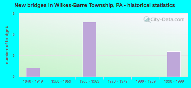
- New bridges - historical statistics
- 21940-1949
- 131960-1969
- 61990-1999

- Reconstructed bridges - Historical Statistics
- 41970-1979
- 11980-1989


- Bridge Condition - Deck
- 37.5%Good
- 37.5%Fair
- 25.0%Poor

- Bridge Condition - Superstructure
- 25.0%Good
- 50.0%Satisfactory
- 25.0%Poor

- Bridge Condition - Substructure
- 25.0%Good
- 25.0%Satisfactory
- 25.0%Fair
- 25.0%Poor
Find on map >> Show street view
Structure Number: 23739, Location: W-B TWP .2 M N EXIT 165 (Lat: 41.222406, Lng: -75.879281), Route carried "on" structure: Interstate 81, Year Built: 1966, Year Reconstructed: 1982, Status: Open, Structure Length: 6.89m (22.60ft), Average Daily Traffic: 27,674 (year 2022), Truck Traffic: 24%, Average Future Daily Traffic: 35,594 (year 2032), Design Load: HS 20+Mod, Features Intersected: JOHNSON,ALLAN,SPRING RUN
Minimum Vertical Clearance: 30+ m (98+ ft), Kilometerpoint: 42.258, Lanes on structure: 2, Lanes under structure: 4, Base Highway Network: Yes, Owner: State Highway Agency, Approaching Roadway Width: 10.1m (33.1ft), Skew: 10 degrees, Material/Design: Prestressed concrete, Design/Construction: Box Beam or Girders - Single/Spread, Number Of Spans In Main Unit: 5, Length of Maximum Span: 15.5m (50.9ft), Curb or Sidewalk Widths: Left: 0.2m (0.7ft), Right: 0.2m (0.7ft), Curb-To-Curb Width: 10.0m (32.8ft), Out-to-Out Width: 11.4m (37.4ft)
Condition: Deck: Poor, Superstructure: Poor, Substructure: Poor, Channel: Good, Operating Rating: 83.5 metric tons, Method Used To Determine Operating Rating: Load Factor (LF), Inventory Rating: 24.5 metric tons, Method Used To Determine Inventory Rating: Load Factor (LF), Structural Evaluation: Meets minimum limits, Deck Geometry: Meets minimum limits, Underclear: High priority of corrective action, Waterway Adequacy: Superior to present desirable criteria, Approach Roadway Alignment: Equal to present desirable criteria, Length Of Structure Improvement: 6.90m (22.64ft), Designated Inspection Frequency: Every 24 months, Other Special Inspection Frequency: Every 6 months, Inspection Date: October 2021, Other Special Inspection Date: October 2021, Bridge Improvement Cost: $57,000, Roadway Improvement Cost: $167,000, Total Project Cost: $766,000, Deck Structure Type: Concrete Cast-file-Place, Wearing Surface/Protective System: Wearing Surface: Latex Concrete
Find on map >> Show street view
Structure Number: 2374, Location: W-B TWP .2 M N EXIT 165 (Lat: 41.222525, Lng: -75.879578), Route carried "on" structure: Interstate 81, Year Built: 1966, Year Reconstructed: 1982, Status: Open, Structure Length: 6.77m (22.21ft), Average Daily Traffic: 31,319 (year 2022), Truck Traffic: 22%, Average Future Daily Traffic: 40,964 (year 2032), Design Load: HS 20+Mod, Features Intersected: JOHNSON,ALLAN,SPRING RUN
Minimum Vertical Clearance: 30+ m (98+ ft), Kilometerpoint: 42.561, Lanes on structure: 2, Lanes under structure: 4, Base Highway Network: Yes, Owner: State Highway Agency, Approaching Roadway Width: 9.8m (32.2ft), Skew: 10 degrees, Material/Design: Prestressed concrete, Design/Construction: Box Beam or Girders - Single/Spread, Number Of Spans In Main Unit: 5, Length of Maximum Span: 15.8m (51.8ft), Curb or Sidewalk Widths: Left: 0.2m (0.7ft), Right: 0.2m (0.7ft), Curb-To-Curb Width: 10.0m (32.8ft), Out-to-Out Width: 11.4m (37.4ft)
Condition: Deck: Poor, Superstructure: Poor, Substructure: Poor, Channel: Good, Operating Rating: 68.9 metric tons, Method Used To Determine Operating Rating: Load Factor (LF), Inventory Rating: 19.1 metric tons, Method Used To Determine Inventory Rating: Load Factor (LF), Structural Evaluation: Meets minimum limits, Deck Geometry: Meets minimum limits, Underclear: High priority of corrective action, Waterway Adequacy: Superior to present desirable criteria, Approach Roadway Alignment: Equal to present desirable criteria, Length Of Structure Improvement: 6.80m (22.31ft), Designated Inspection Frequency: Every 24 months, Inspection Date: October 2021, Bridge Improvement Cost: $33,000, Roadway Improvement Cost: $100,000, Total Project Cost: $450,000, Deck Structure Type: Concrete Cast-file-Place, Wearing Surface/Protective System: Wearing Surface: Latex Concrete
Find on map >> Show street view
Structure Number: 23741, Location: I-81 NB OVER SR2007 (Lat: 41.228497, Lng: -75.869694), Route carried "on" structure: Interstate 81, Year Built: 1966, Year Reconstructed: 1979, Status: Open, Structure Length: 3.11m (10.20ft), Average Daily Traffic: 27,674 (year 2022), Truck Traffic: 24%, Average Future Daily Traffic: 35,594 (year 2032), Design Load: HS 20+Mod, Features Intersected: SR 2007 NORTHAMPTON ST
Minimum Vertical Clearance: 30+ m (98+ ft), Kilometerpoint: 43.858, Lanes on structure: 2, Lanes under structure: 2, Base Highway Network: Yes, Owner: State Highway Agency, Approaching Roadway Width: 11.9m (39.0ft), Skew: 10 degrees, Material/Design: Prestressed concrete, Design/Construction: Box Beam or Girders - Single/Spread, Number Of Spans In Main Unit: 3, Length of Maximum Span: 13.7m (44.9ft), Curb or Sidewalk Widths: Left: 0.2m (0.7ft), Right: 0.2m (0.7ft), Curb-To-Curb Width: 12.4m (40.7ft), Out-to-Out Width: 13.9m (45.6ft)
Condition: Deck: Fair, Superstructure: Satisfactory, Substructure: Fair, Operating Rating: 77.1 metric tons, Method Used To Determine Operating Rating: Load Factor (LF), Inventory Rating: 39.0 metric tons, Method Used To Determine Inventory Rating: Load Factor (LF), Structural Evaluation: Somewhat better than minimum adequacy, Deck Geometry: Better than present minimum criteria, Underclear: High priority of corrective action, Approach Roadway Alignment: Equal to present desirable criteria, Length Of Structure Improvement: 3.10m (10.17ft), Designated Inspection Frequency: Every 24 months, Inspection Date: September 2021, Deck Structure Type: Concrete Cast-file-Place, Wearing Surface/Protective System: Wearing Surface: Latex Concrete
Find on map >> Show street view
Structure Number: 23742, Location: WB TWP WILLOW ST OVR I-81 (Lat: 41.228333, Lng: -75.866667), Route carried "on" structure: State highway , Year Built: 1966, Year Reconstructed: 1993, Status: Open, Structure Length: 7.10m (23.29ft), Average Daily Traffic: 196 (year 2021), Truck Traffic: 3%, Average Future Daily Traffic: 196 (year 2032), Features Intersected: SR 0081 I-81, Facility Carried by Structure: SR 2101 WILLOW ST
Minimum Vertical Clearance: 5.46m (17.91ft), Kilometerpoint: 0.000, Lanes on structure: 2, Lanes under structure: 4, Owner: State Highway Agency, Approaching Roadway Width: 6.1m (20.0ft), Skew: 2 degrees, Material/Design: Prestressed concrete, Design/Construction: Stringer/Multi-beam, Number Of Spans In Main Unit: 4, Length of Maximum Span: 22.3m (73.2ft), Curb or Sidewalk Widths: Left: 0.2m (0.7ft), Right: 0.2m (0.7ft), Curb-To-Curb Width: 9.2m (30.2ft), Out-to-Out Width: 10.3m (33.8ft)
Condition: Deck: Good, Superstructure: Satisfactory, Substructure: Satisfactory, Operating Rating: 84.4 metric tons, Method Used To Determine Operating Rating: Load Factor (LF), Inventory Rating: 21.8 metric tons, Method Used To Determine Inventory Rating: Load Factor (LF), Structural Evaluation: Equal to present minimum criteria, Deck Geometry: Equal to present minimum criteria, Underclear: Meets minimum limits, Approach Roadway Alignment: Better than present minimum criteria, Length Of Structure Improvement: 8.00m (26.25ft), Designated Inspection Frequency: Every 24 months, Inspection Date: September 2021, Bridge Improvement Cost: $39,000, Roadway Improvement Cost: $114,000, Total Project Cost: $524,000, Deck Structure Type: Concrete Cast-file-Place, Wearing Surface/Protective System: Wearing Surface: Monolithic Concrete
Find on map >> Show street view
Structure Number: 23743, Location: I-81 SB OVER SR2007 (Lat: 41.228717, Lng: -75.869853), Route carried "on" structure: Interstate 81, Year Built: 1966, Year Reconstructed: 1979, Status: Open, Structure Length: 3.11m (10.20ft), Average Daily Traffic: 31,319 (year 2022), Truck Traffic: 22%, Average Future Daily Traffic: 40,964 (year 2032), Design Load: HS 20+Mod, Features Intersected: SR 2007 NORTHAMPTON ST
Minimum Vertical Clearance: 30+ m (98+ ft), Kilometerpoint: 44.122, Lanes on structure: 2, Lanes under structure: 2, Base Highway Network: Yes, Owner: State Highway Agency, Approaching Roadway Width: 11.6m (38.1ft), Skew: 10 degrees, Material/Design: Prestressed concrete, Design/Construction: Box Beam or Girders - Single/Spread, Number Of Spans In Main Unit: 3, Length of Maximum Span: 14.3m (46.9ft), Curb or Sidewalk Widths: Left: 0.2m (0.7ft), Right: 0.2m (0.7ft), Curb-To-Curb Width: 12.4m (40.7ft), Out-to-Out Width: 13.9m (45.6ft)
Condition: Deck: Fair, Superstructure: Satisfactory, Substructure: Fair, Operating Rating: 76.2 metric tons, Method Used To Determine Operating Rating: Load Factor (LF), Inventory Rating: 37.2 metric tons, Method Used To Determine Inventory Rating: Load Factor (LF), Structural Evaluation: Somewhat better than minimum adequacy, Deck Geometry: Better than present minimum criteria, Underclear: Meets minimum limits, Approach Roadway Alignment: Equal to present desirable criteria, Length Of Structure Improvement: 3.10m (10.17ft), Designated Inspection Frequency: Every 24 months, Inspection Date: September 2021, Deck Structure Type: Concrete Cast-file-Place, Wearing Surface/Protective System: Wearing Surface: Latex Concrete
Find on map >> Show street view
Structure Number: 24369, Location: W-BARRE TWP OVER SR 2007 (Lat: 41.230836, Lng: -75.871144), Route carried "on" structure: State highway 309B, Year Built: 1946, Status: Open, Structure Length: 1.46m (4.79ft), Average Daily Traffic: 10,622 (year 2020), Truck Traffic: 3%, Average Future Daily Traffic: 14,624 (year 2032), Design Load: HS 20, Features Intersected: SR 2007 E NORTHAMPTON ST, Facility Carried by Structure: SR 6309
Minimum Vertical Clearance: 30+ m (98+ ft), Kilometerpoint: 2.675, Lanes on structure: 2, Lanes under structure: 2, Base Highway Network: Yes, Owner: State Highway Agency, Approaching Roadway Width: 12.2m (40.0ft), Skew: 22 degrees, Material/Design: Steel, Design/Construction: Stringer/Multi-beam, Number Of Spans In Main Unit: 1, Length of Maximum Span: 14.3m (46.9ft), Curb-To-Curb Width: 11.9m (39.0ft), Out-to-Out Width: 13.7m (44.9ft)
Condition: Deck: Fair, Superstructure: Satisfactory, Substructure: Satisfactory, Operating Rating: 40.8 metric tons, Method Used To Determine Operating Rating: Load Factor (LF), Inventory Rating: 24.5 metric tons, Method Used To Determine Inventory Rating: Load Factor (LF), Structural Evaluation: Equal to present minimum criteria, Deck Geometry: Somewhat better than minimum adequacy, Underclear: High priority of corrective action, Approach Roadway Alignment: Equal to present desirable criteria, Length Of Structure Improvement: 1.50m (4.92ft), Designated Inspection Frequency: Every 24 months, Inspection Date: November 2020, Bridge Improvement Cost: $26,000, Roadway Improvement Cost: $100,000, Total Project Cost: $348,000, Deck Structure Type: Concrete Cast-file-Place, Wearing Surface/Protective System: Wearing Surface: Bituminous
Find on map >> Show street view
Structure Number: 40569, Location: I-81 NB OVR SR8051 (Lat: 41.234683, Lng: -75.846461), Route carried "on" structure: Interstate 81, Year Built: 1999, Status: Open, Structure Length: 6.49m (21.29ft), Average Daily Traffic: 27,674 (year 2022), Truck Traffic: 24%, Average Future Daily Traffic: 35,594 (year 2032), Design Load: HS 25 or greater, Features Intersected: SR 8051 I-81 NB RAMPS
Minimum Vertical Clearance: 30+ m (98+ ft), Kilometerpoint: 45.459, Lanes on structure: 3, Lanes under structure: 2, Base Highway Network: Yes, Owner: State Highway Agency, Approaching Roadway Width: 15.8m (51.8ft), Skew: 12 degrees, Material/Design: Prestressed concrete continuous, Design/Construction: Stringer/Multi-beam, Number Of Spans In Main Unit: 3, Length of Maximum Span: 34.7m (113.8ft), Curb or Sidewalk Widths: Left: 0.2m (0.7ft), Right: 0.2m (0.7ft), Curb-To-Curb Width: 15.8m (51.8ft), Out-to-Out Width: 16.9m (55.4ft)
Condition: Deck: Good, Superstructure: Good, Substructure: Good, Operating Rating: 77.1 metric tons, Method Used To Determine Operating Rating: Load Factor (LF), Inventory Rating: 46.3 metric tons, Method Used To Determine Inventory Rating: Load Factor (LF), Structural Evaluation: Better than present minimum criteria, Deck Geometry: Somewhat better than minimum adequacy, Underclear: Equal to present desirable criteria, Approach Roadway Alignment: Equal to present desirable criteria, Length Of Structure Improvement: 6.50m (21.33ft), Designated Inspection Frequency: Every 24 months, Inspection Date: September 2021, Deck Structure Type: Concrete Cast-file-Place, Wearing Surface/Protective System: Wearing Surface: Monolithic Concrete, Deck Protection: Epoxy Coated Reinforcing
Find on map >> Show street view
Structure Number: 4057, Location: WB TWP I-81 SB OVR SR8051 (Lat: 41.234944, Lng: -75.846950), Route carried "on" structure: Interstate 81, Year Built: 1999, Status: Open, Structure Length: 6.83m (22.41ft), Average Daily Traffic: 28,456 (year 2021), Truck Traffic: 20%, Average Future Daily Traffic: 40,964 (year 2032), Design Load: HS 25 or greater, Features Intersected: SR 8051 I-81 NB RAMPS
Minimum Vertical Clearance: 30+ m (98+ ft), Kilometerpoint: 45.730, Lanes on structure: 2, Lanes under structure: 2, Base Highway Network: Yes, Owner: State Highway Agency, Approaching Roadway Width: 12.8m (42.0ft), Skew: 12 degrees, Material/Design: Prestressed concrete continuous, Design/Construction: Stringer/Multi-beam, Number Of Spans In Main Unit: 3, Length of Maximum Span: 34.7m (113.8ft), Curb or Sidewalk Widths: Left: 0.2m (0.7ft), Right: 0.2m (0.7ft), Curb-To-Curb Width: 12.8m (42.0ft), Out-to-Out Width: 13.9m (45.6ft)
Condition: Deck: Good, Superstructure: Good, Substructure: Good, Operating Rating: 71.7 metric tons, Method Used To Determine Operating Rating: Load Factor (LF), Inventory Rating: 42.6 metric tons, Method Used To Determine Inventory Rating: Load Factor (LF), Structural Evaluation: Better than present minimum criteria, Deck Geometry: Equal to present desirable criteria, Underclear: Equal to present desirable criteria, Approach Roadway Alignment: Equal to present desirable criteria, Length Of Structure Improvement: 7.90m (25.92ft), Designated Inspection Frequency: Every 24 months, Inspection Date: September 2021, Deck Structure Type: Concrete Cast-file-Place, Wearing Surface/Protective System: Wearing Surface: Monolithic Concrete, Deck Protection: Epoxy Coated Reinforcing
Find on map >> Show street view
Structure Number: 23739, Location: W-B TWP .2 M N EXIT 165 (Lat: 41.222406, Lng: -75.879281), Route carried "under" structure: Other road , Year Built: 1966, Structure Length: 0. m, Average Daily Traffic: 200 (year 2003), Truck Traffic: 1%, Features Intersected: JOHNSON,ALLAN,SPRING RUN, Facility Carried by Structure: I-81 NB
Minimum Vertical Clearance: 7.17m (23.52ft), Kilometerpoint: 0.000, Lanes on structure: 2, Lanes under structure: 2, Material/Design: Prestressed concrete, Design/Construction: Box Beam or Girders - Single/Spread, Length of Maximum Span: 15.5m (50.9ft)
Find on map >> Show street view
Structure Number: 23739, Location: W-B TWP .2 M N EXIT 165 (Lat: 41.222406, Lng: -75.879281), Route carried "under" structure: City street , Year Built: 1966, Structure Length: 0. m, Average Daily Traffic: 200 (year 1992), Truck Traffic: 1%, Features Intersected: JOHNSON,ALLAN,SPRING RUN, Facility Carried by Structure: I-81 NB
Minimum Vertical Clearance: 4.82m (15.81ft), Kilometerpoint: 0.000, Lanes on structure: 2, Lanes under structure: 2, Material/Design: Prestressed concrete, Design/Construction: Box Beam or Girders - Single/Spread, Length of Maximum Span: 15.5m (50.9ft)
Find on map >> Show street view
Structure Number: 2374, Location: W-B TWP .2 M N EXIT 165 (Lat: 41.222525, Lng: -75.879578), Route carried "under" structure: City street , Year Built: 1966, Structure Length: 0. m, Average Daily Traffic: 200 (year 1992), Truck Traffic: 1%, Features Intersected: JOHNSON,ALLAN,SPRING RUN, Facility Carried by Structure: SR 0081 I-81 SB
Minimum Vertical Clearance: 7.26m (23.82ft), Kilometerpoint: 0.000, Lanes on structure: 2, Lanes under structure: 2, Material/Design: Prestressed concrete, Design/Construction: Box Beam or Girders - Single/Spread, Length of Maximum Span: 15.8m (51.8ft)
Find on map >> Show street view
Structure Number: 2374, Location: W-B TWP .2 M N EXIT 165 (Lat: 41.222525, Lng: -75.879578), Route carried "under" structure: City street , Year Built: 1966, Structure Length: 0. m, Average Daily Traffic: 200 (year 1992), Truck Traffic: 1%, Features Intersected: JOHNSON,ALLAN,SPRING RUN, Facility Carried by Structure: SR 0081 I-81 SB
Minimum Vertical Clearance: 5.02m (16.47ft), Kilometerpoint: 0.000, Lanes on structure: 2, Lanes under structure: 2, Material/Design: Prestressed concrete, Design/Construction: Box Beam or Girders - Single/Spread, Length of Maximum Span: 15.8m (51.8ft)
Find on map >> Show street view
Structure Number: 23741, Location: I-81 NB OVER SR2007 (Lat: 41.228497, Lng: -75.869694), Route carried "under" structure: State highway , Year Built: 1966, Structure Length: 0. m, Average Daily Traffic: 4,524 (year 2022), Truck Traffic: 3%, Features Intersected: SR 2007 NORTHAMPTON ST, Facility Carried by Structure: I-81 NB
Minimum Vertical Clearance: 4.73m (15.52ft), Kilometerpoint: 8.723, Lanes on structure: 2, Lanes under structure: 2, Material/Design: Prestressed concrete, Design/Construction: Box Beam or Girders - Single/Spread, Length of Maximum Span: 13.7m (44.9ft)
Find on map >> Show street view
Structure Number: 23742, Location: WB TWP WILLOW ST OVR I-81 (Lat: 41.228333, Lng: -75.866667), Route carried "under" structure: Interstate 81, Year Built: 1966, Structure Length: 0. m, Average Daily Traffic: 27,674 (year 2022), Truck Traffic: 24%, Features Intersected: SR 0081 I-81, Facility Carried by Structure: SR 2101 WILLOW ST
Minimum Vertical Clearance: 5.46m (17.91ft), Kilometerpoint: 43.858, Lanes on structure: 2, Lanes under structure: 2, Material/Design: Prestressed concrete, Design/Construction: Stringer/Multi-beam, Length of Maximum Span: 22.3m (73.2ft)
Find on map >> Show street view
Structure Number: 23742, Location: WB TWP WILLOW ST OVR I-81 (Lat: 41.228333, Lng: -75.866667), Route carried "under" structure: Interstate 81, Year Built: 1966, Structure Length: 0. m, Average Daily Traffic: 31,319 (year 2022), Truck Traffic: 22%, Features Intersected: SR 0081 I-81, Facility Carried by Structure: SR 2101 WILLOW ST
Minimum Vertical Clearance: 5.28m (17.32ft), Kilometerpoint: 44.122, Lanes on structure: 2, Lanes under structure: 2, Material/Design: Prestressed concrete, Design/Construction: Stringer/Multi-beam, Length of Maximum Span: 22.3m (73.2ft)
Find on map >> Show street view
Structure Number: 23743, Location: I-81 SB OVER SR2007 (Lat: 41.228717, Lng: -75.869853), Route carried "under" structure: State highway , Year Built: 1966, Structure Length: 0. m, Average Daily Traffic: 4,524 (year 2022), Truck Traffic: 3%, Features Intersected: SR 2007 NORTHAMPTON ST, Facility Carried by Structure: I-81 SB
Minimum Vertical Clearance: 4.83m (15.85ft), Kilometerpoint: 8.723, Lanes on structure: 2, Lanes under structure: 2, Material/Design: Prestressed concrete, Design/Construction: Box Beam or Girders - Single/Spread, Length of Maximum Span: 14.3m (46.9ft)
Find on map >> Show street view
Structure Number: 24369, Location: W-BARRE TWP OVER SR 2007 (Lat: 41.230836, Lng: -75.871144), Route carried "under" structure: State highway , Year Built: 1946, Structure Length: 0. m, Average Daily Traffic: 6,740 (year 2022), Truck Traffic: 2%, Features Intersected: SR 2007 E NORTHAMPTON ST, Facility Carried by Structure: SR 6309
Minimum Vertical Clearance: 4.29m (14.07ft), Kilometerpoint: 9.558, Lanes on structure: 2, Lanes under structure: 2, Material/Design: Steel, Design/Construction: Stringer/Multi-beam, Length of Maximum Span: 14.3m (46.9ft)
Find on map >> Show street view
Structure Number: 40569, Location: I-81 NB OVR SR8051 (Lat: 41.234683, Lng: -75.846461), Route carried "under" structure: Ramp State highway , Year Built: 1999, Structure Length: 0. m, Average Daily Traffic: 3,766 (year 2021), Truck Traffic: 2%, Features Intersected: SR 8051 I-81 NB RAMPS, Facility Carried by Structure: I-81 NB
Minimum Vertical Clearance: 5.57m (18.27ft), Kilometerpoint: 0.000, Lanes on structure: 3, Lanes under structure: 1, Material/Design: Prestressed concrete continuous, Design/Construction: Stringer/Multi-beam, Length of Maximum Span: 34.7m (113.8ft)
Find on map >> Show street view
Structure Number: 40569, Location: I-81 NB OVR SR8051 (Lat: 41.234683, Lng: -75.846461), Route carried "under" structure: Ramp State highway , Year Built: 1999, Structure Length: 0. m, Average Daily Traffic: 3,296 (year 2021), Truck Traffic: 2%, Features Intersected: SR 8051 I-81 NB RAMPS, Facility Carried by Structure: I-81 NB
Minimum Vertical Clearance: 5.47m (17.95ft), Kilometerpoint: 0.000, Lanes on structure: 3, Lanes under structure: 1, Material/Design: Prestressed concrete continuous, Design/Construction: Stringer/Multi-beam, Length of Maximum Span: 34.7m (113.8ft)
Find on map >> Show street view
Structure Number: 4057, Location: WB TWP I-81 SB OVR SR8051 (Lat: 41.234944, Lng: -75.846950), Route carried "under" structure: Ramp State highway , Year Built: 1999, Structure Length: 0. m, Average Daily Traffic: 3,296 (year 2021), Truck Traffic: 2%, Features Intersected: SR 8051 I-81 NB RAMPS, Facility Carried by Structure: I-81 SB
Minimum Vertical Clearance: 6.77m (22.21ft), Kilometerpoint: 0.000, Lanes on structure: 2, Lanes under structure: 1, Material/Design: Prestressed concrete continuous, Design/Construction: Stringer/Multi-beam, Length of Maximum Span: 34.7m (113.8ft)
Find on map >> Show street view
Structure Number: 4057, Location: WB TWP I-81 SB OVR SR8051 (Lat: 41.234944, Lng: -75.846950), Route carried "under" structure: Ramp State highway , Year Built: 1999, Structure Length: 0. m, Average Daily Traffic: 3,766 (year 2021), Truck Traffic: 2%, Features Intersected: SR 8051 I-81 NB RAMPS, Facility Carried by Structure: I-81 SB
Minimum Vertical Clearance: 6.80m (22.31ft), Kilometerpoint: 0.000, Lanes on structure: 2, Lanes under structure: 1, Material/Design: Prestressed concrete continuous, Design/Construction: Stringer/Multi-beam, Length of Maximum Span: 34.7m (113.8ft)