Bridge Statistics for Wilcox, Pennsylvania (PA)
Condition, Traffic, Stress, Structural Evaluation, Project Costs
- National Bridge Inventory (NBI) Statistics
- 11Number of bridges
- 66ft / 19.6mTotal length
- $1,667,000Total costs
- 19,291Total average daily traffic
- 2,729Total average daily truck traffic
- National Bridge Inventory (NBI) Registered Bridges for Wilcox
- No street view available for this location
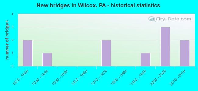
- New bridges - historical statistics
- 21930-1939
- 11940-1949
- 21970-1979
- 11990-1999
- 32000-2009
- 22010-2019

- Reconstructed bridges - Historical Statistics
- 11940-1949
- 01950-1959
- 01960-1969
- 01970-1979
- 01980-1989
- 01990-1999
- 02000-2009
- 12010-2019


- Bridge Condition - Deck
- 10.0%Very good
- 40.0%Good
- 50.0%Fair

- Bridge Condition - Superstructure
- 30.0%Very good
- 20.0%Good
- 30.0%Satisfactory
- 20.0%Fair

- Bridge Condition - Substructure
- 20.0%Very good
- 40.0%Good
- 30.0%Satisfactory
- 10.0%Fair

- Bridge Condition - Channel
- 37.5%Good
- 12.5%Satisfactory
- 37.5%Fair
- 12.5%Poor
Find on map >> Show street view
Structure Number: 15572, Location: 2 MI N WILCOX (Lat: 41.604356, Lng: -78.676658), Route carried "on" structure: US 219, Year Built: 1948, Status: Open, Structure Length: 1.65m (5.41ft), Average Daily Traffic: 2,960 (year 2021), Truck Traffic: 26%, Average Future Daily Traffic: 4,308 (year 2040), Design Load: HS 20, Features Intersected: ROCKY RUN
Minimum Vertical Clearance: 30+ m (98+ ft), Kilometerpoint: 50.331, Lanes on structure: 2, Base Highway Network: Yes, Owner: State Highway Agency, Approaching Roadway Width: 10.7m (35.1ft), Skew: 1 degrees, Material/Design: Concrete, Design/Construction: Tee Beam, Number Of Spans In Main Unit: 2, Length of Maximum Span: 7.9m (25.9ft), Curb or Sidewalk Widths: Left: 0.0m, Right: 0.1m (0.3ft), Curb-To-Curb Width: 11.1m (36.4ft), Out-to-Out Width: 12.0m (39.4ft)
Condition: Deck: Fair, Superstructure: Fair, Substructure: Satisfactory, Channel: Fair, Operating Rating: 79.8 metric tons, Method Used To Determine Operating Rating: Allowable Stress (AS), Inventory Rating: 50.8 metric tons, Method Used To Determine Inventory Rating: Allowable Stress (AS), Structural Evaluation: Somewhat better than minimum adequacy, Deck Geometry: Somewhat better than minimum adequacy, Waterway Adequacy: Equal to present desirable criteria, Approach Roadway Alignment: Better than present minimum criteria, Length Of Structure Improvement: 1.60m (5.25ft), Designated Inspection Frequency: Every 24 months, Inspection Date: April 2020, Bridge Improvement Cost: $40,000, Roadway Improvement Cost: $250,000, Total Project Cost: $541,000, Deck Structure Type: Concrete Cast-file-Place, Wearing Surface/Protective System: Wearing Surface: Bituminous
Find on map >> Show street view
Structure Number: 1559, Location: WILCOX (Lat: 41.575836, Lng: -78.691811), Route carried "on" structure: State highway 321, Year Built: 1975, Status: Open, Structure Length: 2.62m (8.60ft), Average Daily Traffic: 2,119 (year 2020), Truck Traffic: 10%, Average Future Daily Traffic: 2,462 (year 2040), Design Load: HS 20, Features Intersected: WEST BRANCH CLARION R
Minimum Vertical Clearance: 30+ m (98+ ft), Kilometerpoint: 0.810, Lanes on structure: 2, Owner: State Highway Agency, Approaching Roadway Width: 7.3m (24.0ft), Skew: 2 degrees, Material/Design: Prestressed concrete, Design/Construction: Box Beam or Girders - Single/Spread, Number Of Spans In Main Unit: 2, Length of Maximum Span: 12.8m (42.0ft), Curb or Sidewalk Widths: Left: 0.2m (0.7ft), Right: 0.2m (0.7ft), Curb-To-Curb Width: 13.4m (44.0ft), Out-to-Out Width: 14.6m (47.9ft)
Condition: Deck: Fair, Superstructure: Satisfactory, Substructure: Satisfactory, Channel: Satisfactory, Operating Rating: 48.1 metric tons, Method Used To Determine Operating Rating: Load Factor (LF), Inventory Rating: 29.0 metric tons, Method Used To Determine Inventory Rating: Load Factor (LF), Structural Evaluation: Equal to present minimum criteria, Deck Geometry: Better than present minimum criteria, Waterway Adequacy: Superior to present desirable criteria, Approach Roadway Alignment: Better than present minimum criteria, Length Of Structure Improvement: 2.60m (8.53ft), Designated Inspection Frequency: Every 24 months, Inspection Date: April 2020, Deck Structure Type: Concrete Cast-file-Place, Wearing Surface/Protective System: Wearing Surface: Latex Concrete
Find on map >> Show street view
Structure Number: 15592, Location: DAHOGA (Lat: 41.597789, Lng: -78.721922), Route carried "on" structure: State highway 321, Year Built: 1975, Status: Open, Structure Length: 1.62m (5.31ft), Average Daily Traffic: 2,119 (year 2020), Truck Traffic: 10%, Average Future Daily Traffic: 2,462 (year 2040), Design Load: HS 20, Features Intersected: HIGH PRESSURE GAS LINES
Minimum Vertical Clearance: 30+ m (98+ ft), Kilometerpoint: 3.842, Lanes on structure: 2, Owner: State Highway Agency, Approaching Roadway Width: 7.3m (24.0ft), Material/Design: Prestressed concrete, Design/Construction: Box Beam or Girders - Single/Spread, Number Of Spans In Main Unit: 1, Length of Maximum Span: 15.8m (51.8ft), Curb-To-Curb Width: 13.4m (44.0ft), Out-to-Out Width: 14.6m (47.9ft)
Condition: Deck: Fair, Superstructure: Satisfactory, Substructure: Good, Operating Rating: 78.9 metric tons, Method Used To Determine Operating Rating: Load Factor (LF), Inventory Rating: 40.8 metric tons, Method Used To Determine Inventory Rating: Load Factor (LF), Structural Evaluation: Equal to present minimum criteria, Deck Geometry: Better than present minimum criteria, Approach Roadway Alignment: Better than present minimum criteria, Length Of Structure Improvement: 1.60m (5.25ft), Designated Inspection Frequency: Every 24 months, Inspection Date: April 2020, Bridge Improvement Cost: $36,000, Roadway Improvement Cost: $250,000, Total Project Cost: $481,000, Deck Structure Type: Concrete Cast-file-Place, Wearing Surface/Protective System: Wearing Surface: Latex Concrete
Find on map >> Show street view
Structure Number: 1575, Location: 1000FT SW OF DAHOGA (Lat: 41.598100, Lng: -78.727697), Route carried "on" structure: ServiceCity street , Year Built: 1990, Status: Open, Structure Length: 0.82m (2.69ft), Average Daily Traffic: 50 (year 2021), Average Future Daily Traffic: 64 (year 2041), Design Load: HS 20, Features Intersected: HOFFMAN RUN, Facility Carried by Structure: T-364 (DAHOGA RD)
Minimum Vertical Clearance: 30+ m (98+ ft), Kilometerpoint: 0.000, Lanes on structure: 1, Owner: Town or Township Highway Agency, Approaching Roadway Width: 4.3m (14.1ft), Material/Design: Wood or Timber, Design/Construction: Slab, Number Of Spans In Main Unit: 1, Length of Maximum Span: 7.6m (24.9ft), Curb-To-Curb Width: 4.4m (14.4ft), Out-to-Out Width: 4.9m (16.1ft)
Condition: Deck: Fair, Superstructure: Fair, Substructure: Fair, Channel: Fair, Operating Rating: 49.0 metric tons, Method Used To Determine Operating Rating: Allowable Stress (AS), Inventory Rating: 36.3 metric tons, Method Used To Determine Inventory Rating: Allowable Stress (AS), Structural Evaluation: Somewhat better than minimum adequacy, Deck Geometry: Equal to present minimum criteria, Waterway Adequacy: Better than present minimum criteria, Approach Roadway Alignment: Better than present minimum criteria, Length Of Structure Improvement: 1.40m (4.59ft), Designated Inspection Frequency: Every 24 months, Inspection Date: October 2021, Deck Structure Type: Wood or Timber
Find on map >> Show street view
Structure Number: 15752, Location: 600FT WEST OF US219 INTER (Lat: 41.605636, Lng: -78.678922), Route carried "on" structure: City street , Year Built: 1930, Year Reconstructed: 2010, Status: Open, Structure Length: 1.19m (3.90ft), Average Daily Traffic: 50 (year 2021), Average Future Daily Traffic: 79 (year 2041), Design Load: HS 20, Features Intersected: W BRANCH CLARION RIVER, Facility Carried by Structure: T-368 HORNER ROAD
Minimum Vertical Clearance: 30+ m (98+ ft), Kilometerpoint: 0.000, Lanes on structure: 1, Owner: Town or Township Highway Agency, Approaching Roadway Width: 4.3m (14.1ft), Material/Design: Steel, Design/Construction: Stringer/Multi-beam, Number Of Spans In Main Unit: 1, Length of Maximum Span: 11.6m (38.1ft), Curb-To-Curb Width: 4.9m (16.1ft), Out-to-Out Width: 6.6m (21.7ft)
Condition: Deck: Fair, Superstructure: Satisfactory, Substructure: Satisfactory, Channel: Poor, Operating Rating: 61.7 metric tons, Method Used To Determine Operating Rating: Load Factor (LF), Inventory Rating: 37.2 metric tons, Method Used To Determine Inventory Rating: Load Factor (LF), Structural Evaluation: Equal to present minimum criteria, Deck Geometry: High priority of corrective action, Waterway Adequacy: Equal to present minimum criteria, Approach Roadway Alignment: Better than present minimum criteria, Length Of Structure Improvement: 1.20m (3.94ft), Designated Inspection Frequency: Every 24 months, Inspection Date: September 2021, Bridge Improvement Cost: $48,000, Roadway Improvement Cost: $268,000, Total Project Cost: $645,000, Deck Structure Type: Wood or Timber, Wearing Surface/Protective System: Wearing Surface: Wood or Timber
Find on map >> Show street view
Structure Number: 15753, Location: 130 FT WEST OF SR 219 (Lat: 41.579150, Lng: -78.689086), Route carried "on" structure: City street , Year Built: 2003, Status: Open, Structure Length: 2.32m (7.61ft), Average Daily Traffic: 623 (year 2021), Truck Traffic: 1%, Average Future Daily Traffic: 839 (year 2041), Design Load: HL 93, Features Intersected: WEST BR CLARION RIVER, Facility Carried by Structure: T-631 OLD KANE RD
Minimum Vertical Clearance: 30+ m (98+ ft), Kilometerpoint: 0.000, Lanes on structure: 2, Owner: Town or Township Highway Agency, Approaching Roadway Width: 9.1m (29.9ft), Skew: 1 degrees, Material/Design: Prestressed concrete, Design/Construction: Box Beam or Girders - Single/Spread, Number Of Spans In Main Unit: 1, Length of Maximum Span: 22.6m (74.1ft), Curb or Sidewalk Widths: Left: 0.2m (0.7ft), Right: 0.2m (0.7ft), Curb-To-Curb Width: 9.1m (29.9ft), Out-to-Out Width: 9.9m (32.5ft)
Condition: Deck: Good, Superstructure: Good, Substructure: Good, Channel: Good, Operating Rating: 55.3 metric tons, Method Used To Determine Operating Rating: Load and Resistance Factor (LRFR), Inventory Rating: 42.6 metric tons, Method Used To Determine Inventory Rating: Load and Resistance Factor (LRFR), Structural Evaluation: Better than present minimum criteria, Deck Geometry: Equal to present minimum criteria, Waterway Adequacy: Superior to present desirable criteria, Approach Roadway Alignment: Equal to present desirable criteria, Length Of Structure Improvement: 3.00m (9.84ft), Designated Inspection Frequency: Every 24 months, Inspection Date: September 2021, Deck Structure Type: Concrete Cast-file-Place, Wearing Surface/Protective System: Wearing Surface: Monolithic Concrete, Deck Protection: Epoxy Coated Reinforcing
Find on map >> Show street view
Structure Number: 42034, Location: 2 MILES SOUTH OF BRADFORD (Lat: 41.625106, Lng: -78.676111), Route carried "on" structure: US 219, Year Built: 2003, Status: Open, Structure Length: 3.08m (10.10ft), Average Daily Traffic: 8,614 (year 2021), Truck Traffic: 15%, Average Future Daily Traffic: 13,750 (year 2040), Design Load: HS 25 or greater, Features Intersected: SR 4002
Minimum Vertical Clearance: 30+ m (98+ ft), Kilometerpoint: 38.055, Lanes on structure: 2, Lanes under structure: 2, Base Highway Network: Yes, Owner: State Highway Agency, Approaching Roadway Width: 13.4m (44.0ft), Material/Design: Prestressed concrete, Design/Construction: Box Beam or Girders - Single/Spread, Number Of Spans In Main Unit: 1, Length of Maximum Span: 30.2m (99.1ft), Curb or Sidewalk Widths: Left: 0.1m (0.3ft), Right: 0.1m (0.3ft), Curb-To-Curb Width: 13.4m (44.0ft), Out-to-Out Width: 14.3m (46.9ft)
Condition: Deck: Good, Superstructure: Very good, Substructure: Good, Operating Rating: 74.4 metric tons, Method Used To Determine Operating Rating: Load Factor (LF), Inventory Rating: 44.5 metric tons, Method Used To Determine Inventory Rating: Load Factor (LF), Structural Evaluation: Better than present minimum criteria, Deck Geometry: Equal to present minimum criteria, Underclear: Better than present minimum criteria, Approach Roadway Alignment: Equal to present desirable criteria, Length Of Structure Improvement: 3.80m (12.47ft), Designated Inspection Frequency: Every 24 months, Inspection Date: June 2020, Deck Structure Type: Concrete Cast-file-Place, Wearing Surface/Protective System: Wearing Surface: Monolithic Concrete, Deck Protection: Epoxy Coated Reinforcing
Find on map >> Show street view
Structure Number: 46831, Location: WILCOX (Lat: 41.575639, Lng: -78.692722), Route carried "on" structure: State highway , Year Built: 2011, Status: Open, Structure Length: 3.14m (10.30ft), Average Daily Traffic: 385 (year 2022), Truck Traffic: 10%, Average Future Daily Traffic: 710 (year 2040), Design Load: HL 93, Features Intersected: WILSON RUN, Facility Carried by Structure: SR 1006
Minimum Vertical Clearance: 30+ m (98+ ft), Kilometerpoint: 0.000, Lanes on structure: 2, Owner: State Highway Agency, Approaching Roadway Width: 8.5m (27.9ft), Skew: 1 degrees, Material/Design: Prestressed concrete, Design/Construction: Stringer/Multi-beam, Number Of Spans In Main Unit: 1, Length of Maximum Span: 30.5m (100.1ft), Curb or Sidewalk Widths: Left: 0.2m (0.7ft), Right: 0.2m (0.7ft), Curb-To-Curb Width: 8.5m (27.9ft), Out-to-Out Width: 9.6m (31.5ft)
Condition: Deck: Very good, Superstructure: Very good, Substructure: Very good, Channel: Good, Operating Rating: 71.0 metric tons, Method Used To Determine Operating Rating: Assigned ratings based on Load and Resistance Factor Design (LRFD) reported by rating factor (RF) using HL93 loadings, Inventory Rating: 37.6 metric tons, Method Used To Determine Inventory Rating: Assigned ratings based on Load and Resistance Factor Design (LRFD) reported by rating factor (RF) using HL93 loadings, Structural Evaluation: Equal to present desirable criteria, Deck Geometry: Equal to present minimum criteria, Waterway Adequacy: Equal to present desirable criteria, Approach Roadway Alignment: Equal to present desirable criteria, Designated Inspection Frequency: Every 24 months, Inspection Date: April 2020, Deck Structure Type: Concrete Cast-file-Place, Wearing Surface/Protective System: Wearing Surface: Monolithic Concrete, Deck Protection: Epoxy Coated Reinforcing
Find on map >> Show street view
Structure Number: 57078, Location: 300 FT WEST OF SR 321 (Lat: 41.598889, Lng: -78.726267), Route carried "on" structure: City street , Year Built: 2019, Status: Open, Structure Length: 1.83m (6.00ft), Average Daily Traffic: 100 (year 2021), Truck Traffic: 1%, Average Future Daily Traffic: 140 (year 2041), Design Load: HL 93, Features Intersected: WILSON RUN, Facility Carried by Structure: T-361 TWIN LAKES
Minimum Vertical Clearance: 30+ m (98+ ft), Kilometerpoint: 0.000, Lanes on structure: 2, Owner: Town or Township Highway Agency, Approaching Roadway Width: 7.3m (24.0ft), Material/Design: Steel, Design/Construction: Stringer/Multi-beam, Number Of Spans In Main Unit: 1, Length of Maximum Span: 17.4m (57.1ft), Curb-To-Curb Width: 7.3m (24.0ft), Out-to-Out Width: 7.6m (24.9ft)
Condition: Deck: Good, Superstructure: Very good, Substructure: Very good, Channel: Good, Operating Rating: 47.2 metric tons, Method Used To Determine Operating Rating: Assigned ratings based on Load and Resistance Factor Design (LRFD) reported in metric tons, Inventory Rating: 36.3 metric tons, Method Used To Determine Inventory Rating: Assigned ratings based on Load and Resistance Factor Design (LRFD) reported in metric tons, Structural Evaluation: Equal to present desirable criteria, Deck Geometry: Equal to present minimum criteria, Waterway Adequacy: Better than present minimum criteria, Approach Roadway Alignment: Equal to present desirable criteria, Designated Inspection Frequency: Every 24 months, Inspection Date: September 2021, Deck Structure Type: Wood or Timber, Wearing Surface/Protective System: Wearing Surface: Wood or Timber
Find on map >> Show street view
Structure Number: 91904000001021, Location: 0.8 MILES NW OF SR 321 (Lat: 41.602350, Lng: -78.735839), Route carried "on" structure: Federal lands road 191, Year Built: 1937, Year Reconstructed: 1949, Status: Posted for load, Structure Length: 1.34m (4.40ft), Average Daily Traffic: 30 (year 0000), Average Future Daily Traffic: 45 (year 2042), Design Load: HS 15, Features Intersected: HOFFMAN RUN
Minimum Vertical Clearance: 30+ m (98+ ft), Kilometerpoint: 7.360, Lanes on structure: 2, Owner: U.S. Forest Service, Approaching Roadway Width: 6.1m (20.0ft), Material/Design: Steel, Design/Construction: Stringer/Multi-beam, Number Of Spans In Main Unit: 1, Length of Maximum Span: 12.5m (41.0ft), Curb or Sidewalk Widths: Left: 0.3m (1.0ft), Right: 0.3m (1.0ft), Curb-To-Curb Width: 6.1m (20.0ft), Out-to-Out Width: 6.7m (22.0ft)
Condition: Deck: Good, Superstructure: Good, Substructure: Good, Channel: Fair, Operating Rating: 26.2 metric tons, Method Used To Determine Operating Rating: Load and Resistance Factor Rating (LRFR) rating reported by rating factor(RF) method using HL-93 loadings, Inventory Rating: 20.1 metric tons, Method Used To Determine Inventory Rating: Load and Resistance Factor Rating (LRFR) rating reported by rating factor(RF) method using HL-93 loadings, Structural Evaluation: Somewhat better than minimum adequacy, Deck Geometry: Somewhat better than minimum adequacy, Waterway Adequacy: Equal to present desirable criteria, Approach Roadway Alignment: Equal to present desirable criteria, Bridge Posting: Required (Relationship of Operating Rating to Maximum Legal Load: > 39.9% below), Designated Inspection Frequency: Every 24 months, Inspection Date: June 2020, Deck Structure Type: Concrete Cast-file-Place, Wearing Surface/Protective System: Wearing Surface: Integral Concrete
Find on map >> Show street view
Structure Number: 42034, Location: 2 MILES SOUTH OF BRADFORD (Lat: 41.625106, Lng: -78.676111), Route carried "under" structure: Business US 219, Year Built: 2003, Structure Length: 0. m, Average Daily Traffic: 2,241 (year 2021), Truck Traffic: 9%, Features Intersected: SR 4002
Minimum Vertical Clearance: 5.25m (17.22ft), Kilometerpoint: 0.000, Lanes on structure: 2, Lanes under structure: 2, Material/Design: Prestressed concrete, Design/Construction: Box Beam or Girders - Single/Spread, Length of Maximum Span: 30.2m (99.1ft)