Bridge Statistics for Whiteville, North Carolina (NC)
Condition, Traffic, Stress, Structural Evaluation, Project Costs
- National Bridge Inventory (NBI) Statistics
- 41Number of bridges
- 351ft / 107mTotal length
- 282,480Total average daily traffic
- 30,336Total average daily truck traffic
- National Bridge Inventory (NBI) Registered Bridges for Whiteville
- No street view available for this location
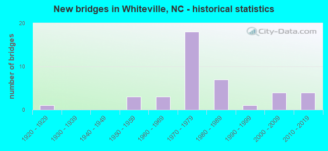
- New bridges - historical statistics
- 11920-1929
- 31950-1959
- 31960-1969
- 181970-1979
- 71980-1989
- 11990-1999
- 42000-2009
- 42010-2019


- Bridge Condition - Deck
- 20.0%Very good
- 30.0%Good
- 30.0%Satisfactory
- 20.0%Fair

- Bridge Condition - Superstructure
- 25.0%Very good
- 50.0%Good
- 10.0%Satisfactory
- 15.0%Fair

- Bridge Condition - Substructure
- 25.0%Very good
- 25.0%Good
- 35.0%Satisfactory
- 15.0%Fair

- Bridge Condition - Channel
- 5.6%Very good
- 66.7%Good
- 5.6%Satisfactory
- 22.2%Fair

- Bridge Condition - Culverts
- 16.7%Good
- 16.7%Satisfactory
- 66.7%Fair
Find on map >> Show street view
Structure Number: 470003, Location: 0.1 MI.S. OF JCT. SR1953 (Lat: 34.317100, Lng: -78.706119), Route carried "on" structure: Business US 701, Year Built: 1961, Status: Open, Structure Length: 4.05m (13.29ft), Average Daily Traffic: 14,000 (year 2018), Truck Traffic: 6%, Average Future Daily Traffic: 28,000 (year 2040), Design Load: HS 20+Mod, Features Intersected: MOLLIE BRANCH
Minimum Vertical Clearance: 30+ m (98+ ft), Kilometerpoint: 0.000, Lanes on structure: 4, Owner: State Highway Agency, Approaching Roadway Width: 16.7m (54.8ft), Material/Design: Concrete continuous, Design/Construction: Slab, Number Of Spans In Main Unit: 6, Length of Maximum Span: 6.7m (22.0ft), Curb or Sidewalk Widths: Left: 1.5m (4.9ft), Right: 1.5m (4.9ft), Curb-To-Curb Width: 13.4m (44.0ft), Out-to-Out Width: 17.1m (56.1ft)
Condition: Deck: Fair, Superstructure: Fair, Substructure: Satisfactory, Channel: Good, Operating Rating: 53.5 metric tons, Method Used To Determine Operating Rating: Load Factor (LF), Inventory Rating: 31.7 metric tons, Method Used To Determine Inventory Rating: Load Factor (LF), Structural Evaluation: Somewhat better than minimum adequacy, Deck Geometry: High priority of replacement, Waterway Adequacy: Better than present minimum criteria, Approach Roadway Alignment: Equal to present desirable criteria, Designated Inspection Frequency: Every 24 months, Inspection Date: July 2020, Deck Structure Type: Concrete Cast-file-Place, Wearing Surface/Protective System: Wearing Surface: Monolithic Concrete
Find on map >> Show street view
Structure Number: 470017, Location: 0.17 MI.N. JCT SR170 (Lat: 34.350733, Lng: -78.702433), Route carried "on" structure: Business US 701, Year Built: 1974, Status: Open, Structure Length: 7.68m (25.20ft), Average Daily Traffic: 3,700 (year 2018), Truck Traffic: 6%, Average Future Daily Traffic: 7,400 (year 2040), Design Load: HS 20+Mod, Features Intersected: US74BYP,US76BYP
Minimum Vertical Clearance: 30+ m (98+ ft), Kilometerpoint: 0.000, Lanes on structure: 2, Lanes under structure: 5, Owner: State Highway Agency, Approaching Roadway Width: 10.0m (32.8ft), Skew: 1 degrees, Material/Design: Steel continuous, Design/Construction: Stringer/Multi-beam, Number Of Spans In Main Unit: 4, Length of Maximum Span: 27.4m (89.9ft), Curb-To-Curb Width: 12.0m (39.4ft), Out-to-Out Width: 12.8m (42.0ft)
Condition: Deck: Good, Superstructure: Very good, Substructure: Satisfactory, Operating Rating: 56.2 metric tons, Method Used To Determine Operating Rating: Load Factor (LF), Inventory Rating: 33.5 metric tons, Method Used To Determine Inventory Rating: Load Factor (LF), Structural Evaluation: Equal to present minimum criteria, Deck Geometry: Somewhat better than minimum adequacy, Underclear: Somewhat better than minimum adequacy, Approach Roadway Alignment: Equal to present desirable criteria, Designated Inspection Frequency: Every 24 months, Inspection Date: July 2020, Deck Structure Type: Concrete Cast-file-Place, Wearing Surface/Protective System: Wearing Surface: Epoxy Overlay, Membrane: Epoxy
Find on map >> Show street view
Structure Number: 470019, Location: 0.4 MI.S.JCT.SR1437 (Lat: 34.318500, Lng: -78.708789), Route carried "on" structure: Bypass US 701, Year Built: 1955, Status: Open, Structure Length: 3.44m (11.29ft), Average Daily Traffic: 15,500 (year 2019), Truck Traffic: 12%, Average Future Daily Traffic: 31,000 (year 2040), Design Load: HS 15, Features Intersected: PINELOG SWAMP
Minimum Vertical Clearance: 30+ m (98+ ft), Kilometerpoint: 0.000, Lanes on structure: 2, Base Highway Network: Yes (Inventory Route: 2, Subroute: 1), Owner: State Highway Agency, Approaching Roadway Width: 8.8m (28.9ft), Material/Design: Concrete, Design/Construction: Tee Beam, Number Of Spans In Main Unit: 3, Length of Maximum Span: 10.9m (35.8ft), Curb-To-Curb Width: 8.5m (27.9ft), Out-to-Out Width: 10.2m (33.5ft)
Condition: Deck: Good, Superstructure: Satisfactory, Substructure: Good, Channel: Good, Operating Rating: 46.2 metric tons, Method Used To Determine Operating Rating: Load Factor (LF), Inventory Rating: 27.2 metric tons, Method Used To Determine Inventory Rating: Load Factor (LF), Structural Evaluation: Equal to present minimum criteria, Deck Geometry: High priority of replacement, Waterway Adequacy: Somewhat better than minimum adequacy, Approach Roadway Alignment: Equal to present desirable criteria, Designated Inspection Frequency: Every 24 months, Inspection Date: September 2021, Deck Structure Type: Concrete Cast-file-Place, Wearing Surface/Protective System: Wearing Surface: Bituminous
Find on map >> Show street view
Structure Number: 470034, Location: 0.2 MI.N. OF JCT.SR1435 (Lat: 34.339428, Lng: -78.758275), Route carried "on" structure: State highway 1585, Year Built: 1974, Status: Open, Structure Length: 9.32m (30.58ft), Average Daily Traffic: 2,800 (year 2017), Truck Traffic: 6%, Average Future Daily Traffic: 5,600 (year 2040), Design Load: HS 20+Mod, Features Intersected: US74/US76BYP
Minimum Vertical Clearance: 30+ m (98+ ft), Kilometerpoint: 0.000, Lanes on structure: 2, Lanes under structure: 4, Owner: State Highway Agency, Approaching Roadway Width: 7.3m (24.0ft), Skew: 3 degrees, Material/Design: Steel continuous, Design/Construction: Stringer/Multi-beam, Number Of Spans In Main Unit: 2, Number Of Approach Spans: 2, Length of Maximum Span: 34.4m (112.9ft), Curb-To-Curb Width: 10.8m (35.4ft), Out-to-Out Width: 11.5m (37.7ft)
Condition: Deck: Satisfactory, Superstructure: Good, Substructure: Satisfactory, Operating Rating: 58.9 metric tons, Method Used To Determine Operating Rating: Load Factor (LF), Inventory Rating: 35.3 metric tons, Method Used To Determine Inventory Rating: Load Factor (LF), Structural Evaluation: Equal to present minimum criteria, Deck Geometry: Somewhat better than minimum adequacy, Underclear: Equal to present minimum criteria, Approach Roadway Alignment: Equal to present desirable criteria, Designated Inspection Frequency: Every 24 months, Inspection Date: June 2020, Deck Structure Type: Concrete Cast-file-Place, Wearing Surface/Protective System: Wearing Surface: Monolithic Concrete
Find on map >> Show street view
Structure Number: 470042, Location: 0.1 MI.S.JCT.SR1437 (Lat: 34.322369, Lng: -78.707769), Route carried "on" structure: Bypass US 701, Year Built: 1953, Status: Open, Structure Length: 5.18m (16.99ft), Average Daily Traffic: 15,500 (year 2019), Truck Traffic: 12%, Average Future Daily Traffic: 31,000 (year 2040), Design Load: H 15, Features Intersected: W.MAIN ST.,CSX
Minimum Vertical Clearance: 30+ m (98+ ft), Kilometerpoint: 0.000, Lanes on structure: 2, Lanes under structure: 2, Base Highway Network: Yes (Inventory Route: 2, Subroute: 1), Owner: State Highway Agency, Approaching Roadway Width: 8.8m (28.9ft), Material/Design: Concrete, Design/Construction: Tee Beam, Number Of Spans In Main Unit: 4, Length of Maximum Span: 12.4m (40.7ft), Curb or Sidewalk Widths: Left: 1.5m (4.9ft), Right: 1.5m (4.9ft), Curb-To-Curb Width: 8.5m (27.9ft), Out-to-Out Width: 12.2m (40.0ft)
Condition: Deck: Satisfactory, Superstructure: Good, Substructure: Satisfactory, Operating Rating: 47.1 metric tons, Method Used To Determine Operating Rating: Load Factor (LF), Inventory Rating: 28.1 metric tons, Method Used To Determine Inventory Rating: Load Factor (LF), Structural Evaluation: Equal to present minimum criteria, Deck Geometry: High priority of replacement, Underclear: High priority of corrective action, Approach Roadway Alignment: Equal to present desirable criteria, Designated Inspection Frequency: Every 24 months, Inspection Date: September 2021, Deck Structure Type: Concrete Cast-file-Place, Wearing Surface/Protective System: Wearing Surface: Monolithic Concrete
Find on map >> Show street view
Structure Number: 47005, Location: 0.3 MI.S. OF JCT.SR1551 (Lat: 34.346831, Lng: -78.719758), Route carried "on" structure: State highway 1552, Year Built: 1972, Status: Open, Structure Length: 10.75m (35.27ft), Average Daily Traffic: 3,600 (year 2015), Truck Traffic: 7%, Average Future Daily Traffic: 7,200 (year 2040), Design Load: HS 15, Features Intersected: US74/US76BYP
Minimum Vertical Clearance: 30+ m (98+ ft), Kilometerpoint: 0.000, Lanes on structure: 2, Lanes under structure: 4, Owner: State Highway Agency, Approaching Roadway Width: 9.4m (30.8ft), Skew: 4 degrees, Material/Design: Steel continuous, Design/Construction: Stringer/Multi-beam, Number Of Spans In Main Unit: 2, Number Of Approach Spans: 2, Length of Maximum Span: 39.9m (130.9ft), Curb-To-Curb Width: 10.9m (35.8ft), Out-to-Out Width: 11.5m (37.7ft)
Condition: Deck: Fair, Superstructure: Good, Substructure: Good, Operating Rating: 46.2 metric tons, Method Used To Determine Operating Rating: Load Factor (LF), Inventory Rating: 27.2 metric tons, Method Used To Determine Inventory Rating: Load Factor (LF), Structural Evaluation: Equal to present minimum criteria, Deck Geometry: Somewhat better than minimum adequacy, Underclear: Somewhat better than minimum adequacy, Approach Roadway Alignment: Equal to present desirable criteria, Designated Inspection Frequency: Every 24 months, Inspection Date: June 2020, Deck Structure Type: Concrete Cast-file-Place, Wearing Surface/Protective System: Wearing Surface: Monolithic Concrete
Find on map >> Show street view
Structure Number: 470051, Location: 0.4 MI.W.JCT.701BUS (Lat: 34.349767, Lng: -78.709622), Route carried "on" structure: Bypass US 74, Year Built: 1972, Status: Open, Structure Length: 5.73m (18.80ft), Average Daily Traffic: 7,250 (year 2019), Truck Traffic: 12%, Average Future Daily Traffic: 14,500 (year 2040), Design Load: HS 20+Mod, Features Intersected: US701 BYP
Minimum Vertical Clearance: 30+ m (98+ ft), Kilometerpoint: 119.422, Lanes on structure: 2, Lanes under structure: 5, Base Highway Network: Yes (Inventory Route: 2, Subroute: 74), Owner: State Highway Agency, Approaching Roadway Width: 9.7m (31.8ft), Skew: 11 degrees, Material/Design: Steel, Design/Construction: Stringer/Multi-beam, Number Of Spans In Main Unit: 3, Length of Maximum Span: 34.1m (111.9ft), Curb-To-Curb Width: 12.0m (39.4ft), Out-to-Out Width: 12.8m (42.0ft)
Condition: Deck: Fair, Superstructure: Good, Substructure: Satisfactory, Operating Rating: 61.6 metric tons, Method Used To Determine Operating Rating: Load Factor (LF), Inventory Rating: 37.1 metric tons, Method Used To Determine Inventory Rating: Load Factor (LF), Structural Evaluation: Equal to present minimum criteria, Deck Geometry: Equal to present minimum criteria, Underclear: Equal to present minimum criteria, Approach Roadway Alignment: Equal to present desirable criteria, Designated Inspection Frequency: Every 24 months, Inspection Date: September 2021, Deck Structure Type: Concrete Cast-file-Place, Wearing Surface/Protective System: Wearing Surface: Monolithic Concrete
Find on map >> Show street view
Structure Number: 470052, Location: 0.4MI W. OF JCT US701BUS (Lat: 34.350044, Lng: -78.709639), Route carried "on" structure: Bypass US 74, Year Built: 1972, Status: Open, Structure Length: 5.73m (18.80ft), Average Daily Traffic: 7,250 (year 2019), Truck Traffic: 12%, Average Future Daily Traffic: 14,500 (year 2040), Design Load: HS 20+Mod, Features Intersected: US701BYP
Minimum Vertical Clearance: 30+ m (98+ ft), Kilometerpoint: 119.422, Lanes on structure: 3, Lanes under structure: 4, Base Highway Network: Yes (Inventory Route: 2, Subroute: 74), Owner: State Highway Agency, Approaching Roadway Width: 18.2m (59.7ft), Skew: 11 degrees, Material/Design: Steel, Design/Construction: Stringer/Multi-beam, Number Of Spans In Main Unit: 3, Length of Maximum Span: 34.1m (111.9ft), Curb-To-Curb Width: 14.4m (47.2ft), Out-to-Out Width: 15.2m (49.9ft)
Condition: Deck: Fair, Superstructure: Good, Substructure: Satisfactory, Operating Rating: 60.7 metric tons, Method Used To Determine Operating Rating: Load Factor (LF), Inventory Rating: 36.2 metric tons, Method Used To Determine Inventory Rating: Load Factor (LF), Structural Evaluation: Equal to present minimum criteria, Deck Geometry: Meets minimum limits, Underclear: Better than present minimum criteria, Approach Roadway Alignment: Equal to present desirable criteria, Designated Inspection Frequency: Every 24 months, Inspection Date: September 2021, Deck Structure Type: Concrete Cast-file-Place, Wearing Surface/Protective System: Wearing Surface: Monolithic Concrete
Find on map >> Show street view
Structure Number: 470053, Location: 0.7MI.W.JCT.US74/US76BUS (Lat: 34.349633, Lng: -78.671253), Route carried "on" structure: Bypass US 74, Year Built: 1974, Status: Open, Structure Length: 6.09m (19.98ft), Average Daily Traffic: 7,250 (year 2019), Truck Traffic: 14%, Average Future Daily Traffic: 14,500 (year 2040), Design Load: HS 20+Mod, Features Intersected: WHITE MARSH SWAMP
Minimum Vertical Clearance: 30+ m (98+ ft), Kilometerpoint: 120.062, Lanes on structure: 2, Base Highway Network: Yes (Inventory Route: 2, Subroute: 74), Owner: State Highway Agency, Approaching Roadway Width: 9.7m (31.8ft), Material/Design: Steel continuous, Design/Construction: Stringer/Multi-beam, Number Of Spans In Main Unit: 4, Length of Maximum Span: 15.2m (49.9ft), Curb-To-Curb Width: 12.0m (39.4ft), Out-to-Out Width: 12.8m (42.0ft)
Condition: Deck: Satisfactory, Superstructure: Fair, Substructure: Fair, Channel: Good, Operating Rating: 59.8 metric tons, Method Used To Determine Operating Rating: Load Factor (LF), Inventory Rating: 35.3 metric tons, Method Used To Determine Inventory Rating: Load Factor (LF), Structural Evaluation: Somewhat better than minimum adequacy, Deck Geometry: Better than present minimum criteria, Waterway Adequacy: Equal to present minimum criteria, Approach Roadway Alignment: Equal to present desirable criteria, Designated Inspection Frequency: Every 24 months, Underwater Inspection Frequency: Every 60 months, Inspection Date: June 2021, Underwater Inspection Date: April 2019, Deck Structure Type: Concrete Cast-file-Place, Wearing Surface/Protective System: Wearing Surface: Monolithic Concrete
Find on map >> Show street view
Structure Number: 470054, Location: 0.7 MI.W JCT.US74/76 (Lat: 34.349900, Lng: -78.671256), Route carried "on" structure: Bypass US 74, Year Built: 1974, Status: Open, Structure Length: 6.09m (19.98ft), Average Daily Traffic: 7,250 (year 2019), Truck Traffic: 14%, Average Future Daily Traffic: 14,500 (year 2040), Design Load: HS 20+Mod, Features Intersected: WHITE MARSH SWAMP
Minimum Vertical Clearance: 30+ m (98+ ft), Kilometerpoint: 120.062, Lanes on structure: 2, Base Highway Network: Yes (Inventory Route: 2, Subroute: 74), Owner: State Highway Agency, Approaching Roadway Width: 10.0m (32.8ft), Skew: 10 degrees, Material/Design: Steel continuous, Design/Construction: Stringer/Multi-beam, Number Of Spans In Main Unit: 4, Length of Maximum Span: 15.2m (49.9ft), Curb-To-Curb Width: 12.0m (39.4ft), Out-to-Out Width: 12.8m (42.0ft)
Condition: Deck: Satisfactory, Superstructure: Satisfactory, Substructure: Fair, Channel: Good, Operating Rating: 58.0 metric tons, Method Used To Determine Operating Rating: Load Factor (LF), Inventory Rating: 34.4 metric tons, Method Used To Determine Inventory Rating: Load Factor (LF), Structural Evaluation: Somewhat better than minimum adequacy, Deck Geometry: Better than present minimum criteria, Waterway Adequacy: Equal to present minimum criteria, Approach Roadway Alignment: Equal to present desirable criteria, Designated Inspection Frequency: Every 24 months, Underwater Inspection Frequency: Every 60 months, Inspection Date: June 2021, Underwater Inspection Date: April 2019, Deck Structure Type: Concrete Cast-file-Place, Wearing Surface/Protective System: Wearing Surface: Monolithic Concrete
Find on map >> Show street view
Structure Number: 470055, Location: 0.8 MI. W. JCT. NC214 (Lat: 34.342653, Lng: -78.672692), Route carried "on" structure: Business US 74, Year Built: 1921, Year Reconstructed: 1941, Status: Open, Structure Length: 4.96m (16.27ft), Average Daily Traffic: 5,500 (year 2019), Truck Traffic: 8%, Average Future Daily Traffic: 11,000 (year 2040), Design Load: H 15, Features Intersected: WHITE MARSH SWAMP
Minimum Vertical Clearance: 30+ m (98+ ft), Kilometerpoint: 0.000, Lanes on structure: 2, Owner: State Highway Agency, Approaching Roadway Width: 8.8m (28.9ft), Material/Design: Concrete, Design/Construction: Tee Beam, Number Of Spans In Main Unit: 5, Length of Maximum Span: 9.7m (31.8ft), Curb or Sidewalk Widths: Left: 0.2m (0.7ft), Right: 0.2m (0.7ft), Curb-To-Curb Width: 10.6m (34.8ft), Out-to-Out Width: 11.5m (37.7ft)
Condition: Deck: Satisfactory, Superstructure: Fair, Substructure: Fair, Channel: Good, Operating Rating: 46.2 metric tons, Method Used To Determine Operating Rating: Load Factor (LF), Inventory Rating: 27.2 metric tons, Method Used To Determine Inventory Rating: Load Factor (LF), Structural Evaluation: Somewhat better than minimum adequacy, Deck Geometry: Meets minimum limits, Waterway Adequacy: Better than present minimum criteria, Approach Roadway Alignment: Equal to present desirable criteria, Designated Inspection Frequency: Every 24 months, Underwater Inspection Frequency: Every 60 months, Inspection Date: September 2021, Underwater Inspection Date: June 2019, Deck Structure Type: Concrete Cast-file-Place, Wearing Surface/Protective System: Wearing Surface: Bituminous
Find on map >> Show street view
Structure Number: 470148, Location: 0.1 MI. W. JCT. SR1439 (Lat: 34.323125, Lng: -78.727922), Route carried "on" structure: State highway 1437, Year Built: 2009, Status: Open, Structure Length: 3.81m (12.50ft), Average Daily Traffic: 2,000 (year 2018), Truck Traffic: 7%, Average Future Daily Traffic: 4,000 (year 2040), Design Load: HS 25 or greater, Features Intersected: PINE LOG BRANCH
Minimum Vertical Clearance: 30+ m (98+ ft), Kilometerpoint: 0.000, Lanes on structure: 2, Owner: State Highway Agency, Approaching Roadway Width: 10.6m (34.8ft), Material/Design: Prestressed concrete, Design/Construction: Slab, Number Of Spans In Main Unit: 3, Number Of Approach Spans: 2, Length of Maximum Span: 16.1m (52.8ft), Curb-To-Curb Width: 10.8m (35.4ft), Out-to-Out Width: 11.9m (39.0ft)
Condition: Deck: Good, Superstructure: Good, Substructure: Very good, Channel: Good, Operating Rating: 74.3 metric tons, Method Used To Determine Operating Rating: Load Factor (LF), Inventory Rating: 44.4 metric tons, Method Used To Determine Inventory Rating: Load Factor (LF), Structural Evaluation: Better than present minimum criteria, Deck Geometry: Equal to present minimum criteria, Waterway Adequacy: Better than present minimum criteria, Approach Roadway Alignment: Equal to present desirable criteria, Designated Inspection Frequency: Every 24 months, Inspection Date: April 2021, Deck Structure Type: Concrete Precast Panels, Wearing Surface/Protective System: Wearing Surface: Bituminous, Deck Protection: Epoxy Coated Reinforcing
Find on map >> Show street view
Structure Number: 470151, Location: 0.3 MI. W. OF JCT. SR1428 (Lat: 34.304278, Lng: -78.744336), Route carried "on" structure: State highway 1429, Year Built: 2002, Status: Open, Structure Length: 3.87m (12.70ft), Average Daily Traffic: 3,300 (year 2016), Truck Traffic: 6%, Average Future Daily Traffic: 6,600 (year 2040), Design Load: HS 20+Mod, Features Intersected: SOULES SWAMP
Minimum Vertical Clearance: 30+ m (98+ ft), Kilometerpoint: 0.000, Lanes on structure: 2, Owner: State Highway Agency, Approaching Roadway Width: 10.0m (32.8ft), Material/Design: Prestressed concrete, Design/Construction: Slab, Number Of Spans In Main Unit: 3, Length of Maximum Span: 13.4m (44.0ft), Curb-To-Curb Width: 10.0m (32.8ft), Out-to-Out Width: 10.9m (35.8ft)
Condition: Deck: Good, Superstructure: Good, Substructure: Satisfactory, Channel: Good, Operating Rating: 75.2 metric tons, Method Used To Determine Operating Rating: Load Factor (LF), Inventory Rating: 45.3 metric tons, Method Used To Determine Inventory Rating: Load Factor (LF), Structural Evaluation: Equal to present minimum criteria, Deck Geometry: Meets minimum limits, Waterway Adequacy: Better than present minimum criteria, Approach Roadway Alignment: Equal to present desirable criteria, Designated Inspection Frequency: Every 24 months, Underwater Inspection Frequency: Every 60 months, Inspection Date: January 2021, Underwater Inspection Date: October 2021, Deck Structure Type: Concrete Precast Panels, Wearing Surface/Protective System: Wearing Surface: Bituminous
Find on map >> Show street view
Structure Number: 470207, Location: 0.3MI.N.JCT.SR1557 (Lat: 34.344492, Lng: -78.752225), Route carried "on" structure: State highway 1585, Year Built: 2012, Status: Open, Structure Length: 2.43m (7.97ft), Average Daily Traffic: 920 (year 2013), Truck Traffic: 6%, Average Future Daily Traffic: 1,840 (year 2025), Design Load: HL 93, Features Intersected: PINE LOG SWAMP
Minimum Vertical Clearance: 30+ m (98+ ft), Kilometerpoint: 0.000, Lanes on structure: 2, Owner: State Highway Agency, Approaching Roadway Width: 9.1m (29.9ft), Material/Design: Prestressed concrete, Design/Construction: Box Beam or Girders - Multiple, Number Of Spans In Main Unit: 1, Length of Maximum Span: 23.1m (75.8ft), Curb-To-Curb Width: 9.2m (30.2ft), Out-to-Out Width: 10.0m (32.8ft)
Condition: Deck: Very good, Superstructure: Very good, Substructure: Very good, Channel: Good, Operating Rating: 74.3 metric tons, Method Used To Determine Operating Rating: Load and Resistance Factor (LRFR), Inventory Rating: 46.2 metric tons, Method Used To Determine Inventory Rating: Load and Resistance Factor (LRFR), Structural Evaluation: Equal to present desirable criteria, Deck Geometry: Equal to present minimum criteria, Waterway Adequacy: Better than present minimum criteria, Approach Roadway Alignment: Equal to present desirable criteria, Designated Inspection Frequency: Every 24 months, Inspection Date: August 2020, Deck Structure Type: Concrete Precast Panels, Wearing Surface/Protective System: Wearing Surface: Bituminous, Deck Protection: Epoxy Coated Reinforcing
Find on map >> Show street view
Structure Number: 470216, Location: 2 MI. N. OF JCT. US74 (Lat: 34.374917, Lng: -78.667556), Route carried "on" structure: State highway 1700, Year Built: 2014, Status: Open, Structure Length: 4.05m (13.29ft), Average Daily Traffic: 1,900 (year 2012), Truck Traffic: 6%, Average Future Daily Traffic: 3,800 (year 2025), Design Load: HL 93, Features Intersected: WELCHES CREEK
Minimum Vertical Clearance: 30+ m (98+ ft), Kilometerpoint: 0.000, Lanes on structure: 2, Owner: State Highway Agency, Approaching Roadway Width: 8.5m (27.9ft), Material/Design: Prestressed concrete, Design/Construction: Slab, Number Of Spans In Main Unit: 3, Length of Maximum Span: 14.6m (47.9ft), Curb-To-Curb Width: 8.6m (28.2ft), Out-to-Out Width: 10.0m (32.8ft)
Condition: Deck: Very good, Superstructure: Very good, Substructure: Very good, Channel: Good, Operating Rating: 64.4 metric tons, Method Used To Determine Operating Rating: Load and Resistance Factor (LRFR), Inventory Rating: 49.8 metric tons, Method Used To Determine Inventory Rating: Load and Resistance Factor (LRFR), Structural Evaluation: Equal to present desirable criteria, Deck Geometry: Somewhat better than minimum adequacy, Waterway Adequacy: Better than present minimum criteria, Approach Roadway Alignment: Equal to present desirable criteria, Designated Inspection Frequency: Every 24 months, Underwater Inspection Frequency: Every 60 months, Inspection Date: August 2020, Underwater Inspection Date: August 2020, Deck Structure Type: Concrete Precast Panels, Wearing Surface/Protective System: Wearing Surface: Bituminous, Deck Protection: Epoxy Coated Reinforcing
Find on map >> Show street view
Structure Number: 470235, Location: 0.8 MI. N. JCT. SR1700 (Lat: 34.378025, Lng: -78.652244), Route carried "on" structure: State highway 1722, Year Built: 2015, Status: Open, Structure Length: 2.95m (9.68ft), Average Daily Traffic: 1,200 (year 2017), Truck Traffic: 6%, Average Future Daily Traffic: 2,400 (year 2040), Design Load: HL 93, Features Intersected: WELCH CREEK
Minimum Vertical Clearance: 30+ m (98+ ft), Kilometerpoint: 0.000, Lanes on structure: 2, Owner: State Highway Agency, Approaching Roadway Width: 9.1m (29.9ft), Material/Design: Prestressed concrete, Design/Construction: Slab, Number Of Spans In Main Unit: 2, Length of Maximum Span: 14.6m (47.9ft), Curb-To-Curb Width: 9.1m (29.9ft), Out-to-Out Width: 10.0m (32.8ft)
Condition: Deck: Very good, Superstructure: Very good, Substructure: Very good, Channel: Very good, Operating Rating: 60.7 metric tons, Method Used To Determine Operating Rating: Load and Resistance Factor (LRFR), Inventory Rating: 43.5 metric tons, Method Used To Determine Inventory Rating: Load and Resistance Factor (LRFR), Structural Evaluation: Equal to present desirable criteria, Deck Geometry: Somewhat better than minimum adequacy, Waterway Adequacy: Better than present minimum criteria, Approach Roadway Alignment: Equal to present desirable criteria, Designated Inspection Frequency: Every 24 months, Underwater Inspection Frequency: Every 60 months, Inspection Date: March 2021, Underwater Inspection Date: June 2020, Deck Structure Type: Concrete Precast Panels, Wearing Surface/Protective System: Wearing Surface: Bituminous, Deck Protection: Epoxy Coated Reinforcing
Find on map >> Show street view
Structure Number: 47024, Location: 0.4 MI.W.JCT.SR1729 (Lat: 34.384994, Lng: -78.639269), Route carried "on" structure: State highway 1710, Year Built: 2015, Status: Open, Structure Length: 2.34m (7.68ft), Average Daily Traffic: 360 (year 2017), Truck Traffic: 6%, Average Future Daily Traffic: 720 (year 2040), Design Load: HL 93, Features Intersected: WELCH CREEK
Minimum Vertical Clearance: 30+ m (98+ ft), Kilometerpoint: 0.000, Lanes on structure: 2, Owner: State Highway Agency, Approaching Roadway Width: 9.1m (29.9ft), Material/Design: Prestressed concrete, Design/Construction: Slab, Number Of Spans In Main Unit: 2, Length of Maximum Span: 14.6m (47.9ft), Curb-To-Curb Width: 9.2m (30.2ft), Out-to-Out Width: 10.0m (32.8ft)
Condition: Deck: Very good, Superstructure: Very good, Substructure: Very good, Channel: Good, Operating Rating: 48.9 metric tons, Method Used To Determine Operating Rating: Load and Resistance Factor (LRFR), Inventory Rating: 38.1 metric tons, Method Used To Determine Inventory Rating: Load and Resistance Factor (LRFR), Structural Evaluation: Equal to present desirable criteria, Deck Geometry: Equal to present minimum criteria, Waterway Adequacy: Better than present minimum criteria, Approach Roadway Alignment: Equal to present desirable criteria, Designated Inspection Frequency: Every 24 months, Underwater Inspection Frequency: Every 60 months, Inspection Date: December 2021, Underwater Inspection Date: July 2020, Deck Structure Type: Concrete Precast Panels, Wearing Surface/Protective System: Wearing Surface: Bituminous, Deck Protection: Epoxy Coated Reinforcing
Find on map >> Show street view
Structure Number: 470361, Location: 0.6MI W JCT US74BUS (Lat: 34.341808, Lng: -78.735000), Route carried "on" structure: State highway 1554, Year Built: 2002, Status: Open, Structure Length: 1.58m (5.18ft), Average Daily Traffic: 650 (year 2018), Truck Traffic: 6%, Average Future Daily Traffic: 1,300 (year 2040), Design Load: HS 20+Mod, Features Intersected: PINE LOG SWAMP
Minimum Vertical Clearance: 30+ m (98+ ft), Kilometerpoint: 0.000, Lanes on structure: 2, Owner: State Highway Agency, Approaching Roadway Width: 5.7m (18.7ft), Material/Design: Prestressed concrete, Design/Construction: Slab, Number Of Spans In Main Unit: 1, Length of Maximum Span: 14.3m (46.9ft), Curb-To-Curb Width: 8.2m (26.9ft), Out-to-Out Width: 9.1m (29.9ft)
Condition: Deck: Good, Superstructure: Good, Substructure: Good, Channel: Good, Operating Rating: 76.2 metric tons, Method Used To Determine Operating Rating: Load Factor (LF), Inventory Rating: 45.3 metric tons, Method Used To Determine Inventory Rating: Load Factor (LF), Structural Evaluation: Better than present minimum criteria, Deck Geometry: Somewhat better than minimum adequacy, Waterway Adequacy: Better than present minimum criteria, Approach Roadway Alignment: Equal to present desirable criteria, Designated Inspection Frequency: Every 24 months, Inspection Date: June 2020, Deck Structure Type: Concrete Precast Panels, Wearing Surface/Protective System: Wearing Surface: Bituminous
Find on map >> Show street view
Structure Number: 47037, Location: 0.2MI.E. OF JCT.SR1585 (Lat: 34.374150, Lng: -78.738433), Route carried "on" structure: State highway 1549, Year Built: 1980, Status: Open, Structure Length: 0.97m (3.18ft), Average Daily Traffic: 230 (year 2017), Truck Traffic: 6%, Average Future Daily Traffic: 460 (year 2040), Design Load: HS 20+Mod, Features Intersected: CANAL
Minimum Vertical Clearance: 30+ m (98+ ft), Kilometerpoint: 0.000, Lanes on structure: 2, Owner: State Highway Agency, Approaching Roadway Width: 5.7m (18.7ft), Skew: 3 degrees, Material/Design: Steel, Design/Construction: Culvert, Number Of Spans In Main Unit: 3, Length of Maximum Span: 2.1m (6.9ft)
Condition: Channel: Good, Culverts: Fair, Operating Rating: 89.8 metric tons, Method Used To Determine Operating Rating: Load and Resistance Factor (LRFR), Inventory Rating: 89.8 metric tons, Method Used To Determine Inventory Rating: Load and Resistance Factor (LRFR), Structural Evaluation: Somewhat better than minimum adequacy, Waterway Adequacy: Somewhat better than minimum adequacy, Approach Roadway Alignment: Equal to present desirable criteria, Designated Inspection Frequency: Every 24 months, Underwater Inspection Frequency: Every 60 months, Inspection Date: April 2021, Underwater Inspection Date: April 2021
Find on map >> Show street view
Structure Number: 470381, Location: 2.5 MI.E. JCT. US701 BUS (Lat: 34.349119, Lng: -78.658253), Route carried "on" structure: US 74, Year Built: 1983, Status: Open, Structure Length: 5.88m (19.29ft), Average Daily Traffic: 7,250 (year 2019), Truck Traffic: 14%, Average Future Daily Traffic: 14,500 (year 2040), Design Load: HS 20+Mod, Features Intersected: SR1700
Minimum Vertical Clearance: 30+ m (98+ ft), Kilometerpoint: 120.306, Lanes on structure: 2, Lanes under structure: 4, Base Highway Network: Yes (Inventory Route: 2, Subroute: 74), Owner: State Highway Agency, Approaching Roadway Width: 12.4m (40.7ft), Skew: 11 degrees, Material/Design: Steel, Design/Construction: Stringer/Multi-beam, Number Of Spans In Main Unit: 3, Number Of Approach Spans: 2, Length of Maximum Span: 37.4m (122.7ft), Curb-To-Curb Width: 12.1m (39.7ft), Out-to-Out Width: 13.0m (42.7ft)
Condition: Deck: Satisfactory, Superstructure: Good, Substructure: Good, Operating Rating: 89.8 metric tons, Method Used To Determine Operating Rating: Load Factor (LF), Inventory Rating: 53.5 metric tons, Method Used To Determine Inventory Rating: Load Factor (LF), Structural Evaluation: Better than present minimum criteria, Deck Geometry: Better than present minimum criteria, Underclear: Equal to present minimum criteria, Approach Roadway Alignment: Equal to present desirable criteria, Designated Inspection Frequency: Every 24 months, Inspection Date: September 2021, Deck Structure Type: Concrete Cast-file-Place, Wearing Surface/Protective System: Wearing Surface: Monolithic Concrete
Find on map >> Show street view
Structure Number: 470382, Location: 2.5 MI.E.JCT.US701 B (Lat: 34.349378, Lng: -78.658108), Route carried "on" structure: US 74, Year Built: 1983, Status: Open, Structure Length: 5.76m (18.90ft), Average Daily Traffic: 7,250 (year 2019), Truck Traffic: 14%, Average Future Daily Traffic: 14,500 (year 2040), Design Load: HS 20+Mod, Features Intersected: SR1700
Minimum Vertical Clearance: 30+ m (98+ ft), Kilometerpoint: 74.372, Lanes on structure: 2, Lanes under structure: 4, Base Highway Network: Yes (Inventory Route: 2, Subroute: 74), Owner: State Highway Agency, Approaching Roadway Width: 12.4m (40.7ft), Skew: 11 degrees, Material/Design: Steel, Design/Construction: Stringer/Multi-beam, Number Of Spans In Main Unit: 3, Length of Maximum Span: 36.8m (120.7ft), Curb-To-Curb Width: 11.9m (39.0ft), Out-to-Out Width: 13.0m (42.7ft)
Condition: Deck: Good, Superstructure: Good, Substructure: Good, Operating Rating: 89.8 metric tons, Method Used To Determine Operating Rating: Load Factor (LF), Inventory Rating: 56.2 metric tons, Method Used To Determine Inventory Rating: Load Factor (LF), Structural Evaluation: Better than present minimum criteria, Deck Geometry: Better than present minimum criteria, Underclear: Equal to present minimum criteria, Approach Roadway Alignment: Equal to present desirable criteria, Designated Inspection Frequency: Every 24 months, Inspection Date: September 2021, Deck Structure Type: Concrete Cast-file-Place, Wearing Surface/Protective System: Wearing Surface: Monolithic Concrete
Find on map >> Show street view
Structure Number: 470393, Location: 0.5 MI. W. OF JCT. SR1431 (Lat: 34.295669, Lng: -78.750667), Route carried "on" structure: State highway 1428, Year Built: 1993, Status: Open, Structure Length: 0.76m (2.49ft), Average Daily Traffic: 320 (year 2018), Truck Traffic: 6%, Average Future Daily Traffic: 640 (year 2040), Design Load: HS 20+Mod, Features Intersected: DEEP BRANCH
Minimum Vertical Clearance: 30+ m (98+ ft), Kilometerpoint: 0.000, Lanes on structure: 2, Owner: State Highway Agency, Approaching Roadway Width: 5.7m (18.7ft), Material/Design: Steel, Design/Construction: Culvert, Number Of Spans In Main Unit: 3, Length of Maximum Span: 2.1m (6.9ft)
Condition: Channel: Fair, Culverts: Fair, Operating Rating: 89.8 metric tons, Method Used To Determine Operating Rating: Load and Resistance Factor (LRFR), Inventory Rating: 89.8 metric tons, Method Used To Determine Inventory Rating: Load and Resistance Factor (LRFR), Structural Evaluation: Somewhat better than minimum adequacy, Waterway Adequacy: Better than present minimum criteria, Approach Roadway Alignment: Equal to present desirable criteria, Designated Inspection Frequency: Every 24 months, Underwater Inspection Frequency: Every 60 months, Inspection Date: December 2021, Underwater Inspection Date: December 2021
Find on map >> Show street view
Structure Number: 470394, Location: 1.5 MI.E. OF JCT.SR1585 (Lat: 34.342144, Lng: -78.735372), Route carried "on" structure: US 74, Year Built: 1972, Status: Open, Structure Length: 1.34m (4.40ft), Average Daily Traffic: 20,000 (year 2017), Truck Traffic: 14%, Average Future Daily Traffic: 40,000 (year 2040), Design Load: HS 20+Mod, Features Intersected: PINELOG BRANCH
Minimum Vertical Clearance: 30+ m (98+ ft), Kilometerpoint: 0.000, Lanes on structure: 4, Base Highway Network: Yes (Inventory Route: 2, Subroute: 74), Owner: State Highway Agency, Approaching Roadway Width: 19.5m (64.0ft), Skew: 4 degrees, Material/Design: Concrete continuous, Design/Construction: Culvert, Number Of Spans In Main Unit: 3, Length of Maximum Span: 3.0m (9.8ft)
Condition: Channel: Fair, Culverts: Fair, Operating Rating: 41.7 metric tons, Method Used To Determine Operating Rating: Field evaluation and documented engineering judgment, Inventory Rating: 32.6 metric tons, Method Used To Determine Inventory Rating: Field evaluation and documented engineering judgment, Structural Evaluation: Somewhat better than minimum adequacy, Waterway Adequacy: Somewhat better than minimum adequacy, Approach Roadway Alignment: Equal to present desirable criteria, Designated Inspection Frequency: Every 24 months, Underwater Inspection Frequency: Every 60 months, Inspection Date: March 2020, Underwater Inspection Date: March 2020
Find on map >> Show street view
Structure Number: 470401, Location: 1.0 MI W. OF JCT NC214 (Lat: 34.341722, Lng: -78.675603), Route carried "on" structure: Business US 74, Year Built: 1962, Status: Open, Structure Length: 0.76m (2.49ft), Average Daily Traffic: 15,000 (year 2017), Truck Traffic: 7%, Average Future Daily Traffic: 30,000 (year 2040), Design Load: HS 20, Features Intersected: WHITE MARSH SWAMP
Minimum Vertical Clearance: 30+ m (98+ ft), Kilometerpoint: 0.000, Lanes on structure: 2, Owner: State Highway Agency, Approaching Roadway Width: 8.2m (26.9ft), Material/Design: Concrete continuous, Design/Construction: Culvert, Number Of Spans In Main Unit: 2, Length of Maximum Span: 3.6m (11.8ft)
Condition: Channel: Fair, Culverts: Satisfactory, Operating Rating: 41.7 metric tons, Method Used To Determine Operating Rating: Field evaluation and documented engineering judgment, Inventory Rating: 32.6 metric tons, Method Used To Determine Inventory Rating: Field evaluation and documented engineering judgment, Structural Evaluation: Equal to present minimum criteria, Waterway Adequacy: Somewhat better than minimum adequacy, Approach Roadway Alignment: Equal to present desirable criteria, Designated Inspection Frequency: Every 24 months, Underwater Inspection Frequency: Every 60 months, Inspection Date: August 2020, Underwater Inspection Date: August 2020
Find on map >> Show street view
Structure Number: 470402, Location: 0.6 MI W. OF JCT NC214 (Lat: 34.343572, Lng: -78.669908), Route carried "on" structure: Business US 74, Year Built: 1962, Status: Open, Structure Length: 0.76m (2.49ft), Average Daily Traffic: 6,800 (year 2017), Truck Traffic: 8%, Average Future Daily Traffic: 13,600 (year 2025), Design Load: HS 20, Features Intersected: WHITE MARSH SWAMP
Minimum Vertical Clearance: 30+ m (98+ ft), Kilometerpoint: 0.000, Lanes on structure: 2, Base Highway Network: Yes, Owner: State Highway Agency, Approaching Roadway Width: 8.2m (26.9ft), Material/Design: Concrete continuous, Design/Construction: Culvert, Number Of Spans In Main Unit: 2, Length of Maximum Span: 3.6m (11.8ft)
Condition: Channel: Fair, Culverts: Fair, Operating Rating: 41.7 metric tons, Method Used To Determine Operating Rating: Field evaluation and documented engineering judgment, Inventory Rating: 32.6 metric tons, Method Used To Determine Inventory Rating: Field evaluation and documented engineering judgment, Structural Evaluation: Somewhat better than minimum adequacy, Waterway Adequacy: Somewhat better than minimum adequacy, Approach Roadway Alignment: Equal to present desirable criteria, Designated Inspection Frequency: Every 24 months, Underwater Inspection Frequency: Every 60 months, Inspection Date: August 2020, Underwater Inspection Date: August 2020
Find on map >> Show street view
Structure Number: 470406, Location: 0.3 MI.W.JCT.US701 (Lat: 34.324644, Lng: -78.713603), Route carried "on" structure: State highway 1437, Year Built: 2005, Status: Open, Structure Length: 1.03m (3.38ft), Average Daily Traffic: 2,600 (year 2019), Truck Traffic: 7%, Average Future Daily Traffic: 5,200 (year 2040), Design Load: HL 93, Features Intersected: CANAL
Minimum Vertical Clearance: 30+ m (98+ ft), Kilometerpoint: 0.000, Lanes on structure: 2, Owner: State Highway Agency, Approaching Roadway Width: 6.4m (21.0ft), Skew: 4 degrees, Material/Design: Aluminum, Iron, Design/Construction: Culvert, Number Of Spans In Main Unit: 2, Length of Maximum Span: 3.3m (10.8ft)
Condition: Channel: Satisfactory, Culverts: Good, Operating Rating: 27.2 metric tons, Method Used To Determine Operating Rating: Load and Resistance Factor (LRFR), Inventory Rating: 20.8 metric tons, Method Used To Determine Inventory Rating: Load and Resistance Factor (LRFR), Structural Evaluation: Somewhat better than minimum adequacy, Waterway Adequacy: Somewhat better than minimum adequacy, Approach Roadway Alignment: Equal to present desirable criteria, Designated Inspection Frequency: Every 24 months, Underwater Inspection Frequency: Every 60 months, Inspection Date: March 2021, Underwater Inspection Date: March 2021
Find on map >> Show street view
Structure Number: 470017, Location: 0.17 MI.N. JCT SR170 (Lat: 34.350733, Lng: -78.702433), Route carried "under" structure: Bypass US 74, Year Built: 1974, Structure Length: 0. m, Average Daily Traffic: 9,000 (year 2018), Truck Traffic: 12%, Features Intersected: US701BUS
Minimum Vertical Clearance: 4.97m (16.31ft), Kilometerpoint: 73.701, Lanes on structure: 2, Lanes under structure: 3, Material/Design: Steel continuous, Design/Construction: Stringer/Multi-beam, Length of Maximum Span: 27.4m (89.9ft)
Find on map >> Show street view
Structure Number: 470017, Location: 0.17 MI.N. JCT SR170 (Lat: 34.350733, Lng: -78.702433), Route carried "under" structure: Bypass US 74, Year Built: 1974, Structure Length: 0. m, Average Daily Traffic: 9,000 (year 2018), Truck Traffic: 12%, Features Intersected: US701BUS
Minimum Vertical Clearance: 5.02m (16.47ft), Kilometerpoint: 73.701, Lanes on structure: 2, Lanes under structure: 2, Material/Design: Steel continuous, Design/Construction: Stringer/Multi-beam, Length of Maximum Span: 27.4m (89.9ft)
Find on map >> Show street view
Structure Number: 470034, Location: 0.2 MI.N. OF JCT.SR1435 (Lat: 34.339428, Lng: -78.758275), Route carried "under" structure: Bypass US 74, Year Built: 1974, Structure Length: 0. m, Average Daily Traffic: 10,000 (year 2017), Truck Traffic: 14%, Features Intersected: SR1585
Minimum Vertical Clearance: 4.95m (16.24ft), Kilometerpoint: 72.695, Lanes on structure: 2, Lanes under structure: 2, Material/Design: Steel continuous, Design/Construction: Stringer/Multi-beam, Length of Maximum Span: 34.4m (112.9ft)
Find on map >> Show street view
Structure Number: 470034, Location: 0.2 MI.N. OF JCT.SR1435 (Lat: 34.339428, Lng: -78.758275), Route carried "under" structure: Bypass US 74, Year Built: 1974, Structure Length: 0. m, Average Daily Traffic: 10,000 (year 2017), Truck Traffic: 14%, Features Intersected: SR1585
Minimum Vertical Clearance: 4.95m (16.24ft), Kilometerpoint: 0.000, Lanes on structure: 2, Lanes under structure: 2, Material/Design: Steel continuous, Design/Construction: Stringer/Multi-beam, Length of Maximum Span: 34.4m (112.9ft)
Find on map >> Show street view
Structure Number: 470042, Location: 0.1 MI.S.JCT.SR1437 (Lat: 34.322369, Lng: -78.707769), Route carried "under" structure: Other road , Year Built: 1953, Structure Length: 0. m, Average Daily Traffic: 100 (year 1993), Truck Traffic: 7%, Features Intersected: US701BYP, Facility Carried by Structure: W. MAIN ST.
Minimum Vertical Clearance: 7.68m (25.20ft), Kilometerpoint: 0.000, Lanes on structure: 2, Lanes under structure: 2, Material/Design: Concrete, Design/Construction: Tee Beam, Length of Maximum Span: 12.4m (40.7ft)
Find on map >> Show street view
Structure Number: 47005, Location: 0.3 MI.S. OF JCT.SR1551 (Lat: 34.346831, Lng: -78.719758), Route carried "under" structure: Bypass US 74, Year Built: 1972, Structure Length: 0. m, Average Daily Traffic: 10,000 (year 2017), Truck Traffic: 12%, Features Intersected: SR1552
Minimum Vertical Clearance: 4.97m (16.31ft), Kilometerpoint: 73.427, Lanes on structure: 2, Lanes under structure: 2, Material/Design: Steel continuous, Design/Construction: Stringer/Multi-beam, Length of Maximum Span: 39.9m (130.9ft)
Find on map >> Show street view
Structure Number: 47005, Location: 0.3 MI.S. OF JCT.SR1551 (Lat: 34.346831, Lng: -78.719758), Route carried "under" structure: Bypass US 74, Year Built: 1972, Structure Length: 0. m, Average Daily Traffic: 10,000 (year 2017), Truck Traffic: 12%, Features Intersected: SR1552
Minimum Vertical Clearance: 5.02m (16.47ft), Kilometerpoint: 73.427, Lanes on structure: 2, Lanes under structure: 2, Material/Design: Steel continuous, Design/Construction: Stringer/Multi-beam, Length of Maximum Span: 39.9m (130.9ft)
Find on map >> Show street view
Structure Number: 470051, Location: 0.4 MI.W.JCT.701BUS (Lat: 34.349767, Lng: -78.709622), Route carried "under" structure: Bypass US 701, Year Built: 1972, Structure Length: 0. m, Average Daily Traffic: 18,000 (year 2019), Truck Traffic: 12%, Features Intersected: US74/US76 BYP EBL
Minimum Vertical Clearance: 4.82m (15.81ft), Kilometerpoint: 0.000, Lanes on structure: 2, Lanes under structure: 3, Material/Design: Steel, Design/Construction: Stringer/Multi-beam, Length of Maximum Span: 34.1m (111.9ft)
Find on map >> Show street view
Structure Number: 470051, Location: 0.4 MI.W.JCT.701BUS (Lat: 34.349767, Lng: -78.709622), Route carried "under" structure: Bypass US 701, Year Built: 1972, Structure Length: 0. m, Average Daily Traffic: 18,000 (year 2019), Truck Traffic: 12%, Features Intersected: US74/US76 BYP EBL
Minimum Vertical Clearance: 4.80m (15.75ft), Kilometerpoint: 0.000, Lanes on structure: 2, Lanes under structure: 2, Material/Design: Steel, Design/Construction: Stringer/Multi-beam, Length of Maximum Span: 34.1m (111.9ft)
Find on map >> Show street view
Structure Number: 470052, Location: 0.4MI W. OF JCT US701BUS (Lat: 34.350044, Lng: -78.709639), Route carried "under" structure: US 701, Year Built: 1972, Structure Length: 0. m, Average Daily Traffic: 9,000 (year 2019), Truck Traffic: 6%, Features Intersected: US74,US76BYP WBL
Minimum Vertical Clearance: 4.87m (15.98ft), Kilometerpoint: 0.000, Lanes on structure: 3, Lanes under structure: 2, Material/Design: Steel, Design/Construction: Stringer/Multi-beam, Length of Maximum Span: 34.1m (111.9ft)
Find on map >> Show street view
Structure Number: 470381, Location: 2.5 MI.E. JCT. US701 BUS (Lat: 34.349119, Lng: -78.658253), Route carried "under" structure: State highway 1700, Year Built: 1983, Structure Length: 0. m, Average Daily Traffic: 2,750 (year 2019), Truck Traffic: 8%, Features Intersected: US74/76 EBL
Minimum Vertical Clearance: 5.71m (18.73ft), Kilometerpoint: 0.000, Lanes on structure: 2, Lanes under structure: 2, Material/Design: Steel, Design/Construction: Stringer/Multi-beam, Length of Maximum Span: 37.4m (122.7ft)
Find on map >> Show street view
Structure Number: 470381, Location: 2.5 MI.E. JCT. US701 BUS (Lat: 34.349119, Lng: -78.658253), Route carried "under" structure: State highway 1700, Year Built: 1983, Structure Length: 0. m, Average Daily Traffic: 2,750 (year 2019), Truck Traffic: 8%, Features Intersected: US74/76 EBL
Minimum Vertical Clearance: 5.23m (17.16ft), Kilometerpoint: 0.000, Lanes on structure: 2, Lanes under structure: 2, Material/Design: Steel, Design/Construction: Stringer/Multi-beam, Length of Maximum Span: 37.4m (122.7ft)
Find on map >> Show street view
Structure Number: 470382, Location: 2.5 MI.E.JCT.US701 B (Lat: 34.349378, Lng: -78.658108), Route carried "under" structure: State highway 1700, Year Built: 1983, Structure Length: 0. m, Average Daily Traffic: 2,750 (year 2019), Truck Traffic: 8%, Features Intersected: US74/76 WBL
Minimum Vertical Clearance: 5.63m (18.47ft), Kilometerpoint: 0.000, Lanes on structure: 2, Lanes under structure: 2, Material/Design: Steel, Design/Construction: Stringer/Multi-beam, Length of Maximum Span: 36.8m (120.7ft)
Find on map >> Show street view
Structure Number: 470382, Location: 2.5 MI.E.JCT.US701 B (Lat: 34.349378, Lng: -78.658108), Route carried "under" structure: State highway 1700, Year Built: 1983, Structure Length: 0. m, Average Daily Traffic: 2,750 (year 2019), Truck Traffic: 8%, Features Intersected: US74/76 WBL
Minimum Vertical Clearance: 5.12m (16.80ft), Kilometerpoint: 0.000, Lanes on structure: 2, Lanes under structure: 2, Material/Design: Steel, Design/Construction: Stringer/Multi-beam, Length of Maximum Span: 36.8m (120.7ft)