Bridge Statistics for Whitehall, Wisconsin (WI)
Condition, Traffic, Stress, Structural Evaluation, Project Costs
- National Bridge Inventory (NBI) Statistics
- 10Number of bridges
- 79ft / 23.9mTotal length
- $295,000Total costs
- 18,925Total average daily traffic
- 1,267Total average daily truck traffic
- 24,429Total future (year 2038) average daily traffic
- National Bridge Inventory (NBI) Registered Bridges for Whitehall
- No street view available for this location
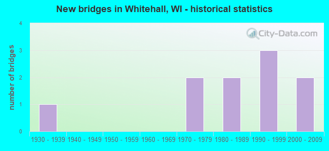
- New bridges - historical statistics
- 11930-1939
- 21970-1979
- 21980-1989
- 31990-1999
- 22000-2009


- Bridge Condition - Deck
- 33.3%Good
- 33.3%Satisfactory
- 33.3%Fair

- Bridge Condition - Superstructure
- 44.4%Good
- 33.3%Satisfactory
- 22.2%Fair

- Bridge Condition - Substructure
- 33.3%Good
- 44.4%Satisfactory
- 22.2%Fair

- Bridge Condition - Channel
- 60.0%Very good
- 20.0%Good
- 20.0%Satisfactory
Find on map >> Show street view
Structure Number: B610057, Location: 0.2M E JCT USH 53 (Lat: 44.349389, Lng: -91.291972), Route carried "on" structure: City street , Year Built: 1977, Status: Open, Structure Length: 4.32m (14.17ft), Average Daily Traffic: 117 (year 2019), Average Future Daily Traffic: 128 (year 2039), Design Load: H 20, Features Intersected: TREMPEALEAU RIVER, Facility Carried by Structure: LRD WADE RD
Minimum Vertical Clearance: 30+ m (98+ ft), Kilometerpoint: 0.000, Lanes on structure: 2, Owner: Town or Township Highway Agency, Approaching Roadway Width: 8.5m (27.9ft), Material/Design: Prestressed concrete continuous, Design/Construction: Stringer/Multi-beam, Number Of Spans In Main Unit: 2, Length of Maximum Span: 21.3m (69.9ft), Curb-To-Curb Width: 8.5m (27.9ft), Out-to-Out Width: 9.1m (29.9ft)
Condition: Deck: Fair, Superstructure: Good, Substructure: Satisfactory, Channel: Good, Operating Rating: 41.0 metric tons, Method Used To Determine Operating Rating: Load Factor (LF), Inventory Rating: 29.2 metric tons, Method Used To Determine Inventory Rating: Load Factor (LF), Structural Evaluation: Equal to present minimum criteria, Deck Geometry: Equal to present minimum criteria, Waterway Adequacy: Equal to present desirable criteria, Approach Roadway Alignment: Equal to present desirable criteria, Designated Inspection Frequency: Every 24 months, Inspection Date: May 2020, Deck Structure Type: Concrete Cast-file-Place, Wearing Surface/Protective System: Wearing Surface: Monolithic Concrete
Find on map >> Show street view
Structure Number: B610063, Location: 2.7M E JCT STH 93 TO S (Lat: 44.368828, Lng: -91.369150), Route carried "on" structure: State highway 121, Year Built: 1980, Status: Open, Structure Length: 4.93m (16.17ft), Average Daily Traffic: 3,700 (year 2018), Truck Traffic: 6%, Average Future Daily Traffic: 4,440 (year 2038), Design Load: HS 20, Features Intersected: TREMPEALEAU RIVER
Minimum Vertical Clearance: 30+ m (98+ ft), Kilometerpoint: 0.000, Lanes on structure: 2, Owner: State Highway Agency, Approaching Roadway Width: 12.2m (40.0ft), Material/Design: Concrete continuous, Design/Construction: Slab, Number Of Spans In Main Unit: 3, Length of Maximum Span: 19.7m (64.6ft), Curb-To-Curb Width: 12.2m (40.0ft), Out-to-Out Width: 13.1m (43.0ft)
Condition: Deck: Satisfactory, Superstructure: Satisfactory, Substructure: Good, Channel: Very good, Operating Rating: 63.7 metric tons, Method Used To Determine Operating Rating: Load Factor (LF), Inventory Rating: 37.3 metric tons, Method Used To Determine Inventory Rating: Load Factor (LF), Structural Evaluation: Equal to present minimum criteria, Deck Geometry: Equal to present minimum criteria, Waterway Adequacy: Equal to present desirable criteria, Approach Roadway Alignment: Equal to present desirable criteria, Designated Inspection Frequency: Every 24 months, Inspection Date: October 2020, Deck Structure Type: Concrete Cast-file-Place, Wearing Surface/Protective System: Wearing Surface: Low Slump Concrete
Find on map >> Show street view
Structure Number: B61011, Location: 7.3M N JCT STH 35 (Lat: 44.168469, Lng: -91.446569), Route carried "on" structure: State highway 93, Year Built: 1998, Status: Open, Structure Length: 3.09m (10.14ft), Average Daily Traffic: 4,400 (year 2019), Truck Traffic: 10%, Average Future Daily Traffic: 5,410 (year 2039), Design Load: HS 20, Features Intersected: TAMARACK CREEK
Minimum Vertical Clearance: 30+ m (98+ ft), Kilometerpoint: 0.000, Lanes on structure: 2, Base Highway Network: Yes, Owner: State Highway Agency, Approaching Roadway Width: 13.1m (43.0ft), Skew: 3 degrees, Material/Design: Concrete, Design/Construction: Slab, Number Of Spans In Main Unit: 2, Length of Maximum Span: 15.0m (49.2ft), Curb-To-Curb Width: 13.2m (43.3ft), Out-to-Out Width: 13.8m (45.3ft)
Condition: Deck: Satisfactory, Superstructure: Satisfactory, Substructure: Satisfactory, Channel: Very good, Operating Rating: 68.6 metric tons, Method Used To Determine Operating Rating: Load Factor (LF), Inventory Rating: 40.5 metric tons, Method Used To Determine Inventory Rating: Load Factor (LF), Structural Evaluation: Equal to present minimum criteria, Deck Geometry: Equal to present minimum criteria, Waterway Adequacy: Equal to present desirable criteria, Approach Roadway Alignment: Equal to present desirable criteria, Designated Inspection Frequency: Every 24 months, Inspection Date: October 2020, Deck Structure Type: Concrete Cast-file-Place, Wearing Surface/Protective System: Wearing Surface: Monolithic Concrete, Deck Protection: Epoxy Coated Reinforcing
Find on map >> Show street view
Structure Number: B610119, Location: 0.1M E JCT USH 53 TO N (Lat: 44.369361, Lng: -91.314778), Route carried "on" structure: City street , Year Built: 1991, Status: Open, Structure Length: 1.28m (4.20ft), Average Daily Traffic: 1,012 (year 2019), Truck Traffic: 15%, Average Future Daily Traffic: 1,113 (year 2039), Design Load: HS 20, Features Intersected: IRVIN CREEK, Facility Carried by Structure: LRD SCRANTON ST
Minimum Vertical Clearance: 30+ m (98+ ft), Kilometerpoint: 0.000, Lanes on structure: 2, Owner: City or Municipal Highway Agency, Approaching Roadway Width: 9.1m (29.9ft), Material/Design: Concrete, Design/Construction: Slab, Number Of Spans In Main Unit: 1, Length of Maximum Span: 12.2m (40.0ft), Curb or Sidewalk Widths: Left: 0.0m, Right: 2.0m (6.6ft), Curb-To-Curb Width: 9.1m (29.9ft), Out-to-Out Width: 11.3m (37.1ft)
Condition: Deck: Good, Superstructure: Good, Substructure: Good, Channel: Satisfactory, Operating Rating: 58.8 metric tons, Method Used To Determine Operating Rating: Load Factor (LF), Inventory Rating: 34.0 metric tons, Method Used To Determine Inventory Rating: Load Factor (LF), Structural Evaluation: Better than present minimum criteria, Deck Geometry: Somewhat better than minimum adequacy, Waterway Adequacy: Equal to present desirable criteria, Approach Roadway Alignment: Equal to present desirable criteria, Designated Inspection Frequency: Every 24 months, Inspection Date: May 2020, Deck Structure Type: Concrete Cast-file-Place, Wearing Surface/Protective System: Wearing Surface: Monolithic Concrete, Deck Protection: Epoxy Coated Reinforcing
Find on map >> Show street view
Structure Number: B610124, Location: 1.5M N JCT STH 121 TO W (Lat: 44.374844, Lng: -91.294144), Route carried "on" structure: US 53, Year Built: 1994, Status: Open, Structure Length: 5.53m (18.14ft), Average Daily Traffic: 4,150 (year 2018), Truck Traffic: 6%, Average Future Daily Traffic: 4,980 (year 2038), Design Load: HS 20, Features Intersected: PIGEON CREEK
Minimum Vertical Clearance: 30+ m (98+ ft), Kilometerpoint: 0.000, Lanes on structure: 2, Owner: State Highway Agency, Approaching Roadway Width: 11.0m (36.1ft), Skew: 3 degrees, Material/Design: Steel continuous, Design/Construction: Stringer/Multi-beam, Number Of Spans In Main Unit: 3, Length of Maximum Span: 21.0m (68.9ft), Curb-To-Curb Width: 13.4m (44.0ft), Out-to-Out Width: 14.0m (45.9ft)
Condition: Deck: Good, Superstructure: Good, Substructure: Satisfactory, Channel: Very good, Operating Rating: 73.0 metric tons, Method Used To Determine Operating Rating: Load Factor (LF), Inventory Rating: 43.7 metric tons, Method Used To Determine Inventory Rating: Load Factor (LF), Structural Evaluation: Equal to present minimum criteria, Deck Geometry: Better than present minimum criteria, Waterway Adequacy: Equal to present desirable criteria, Approach Roadway Alignment: Equal to present desirable criteria, Designated Inspection Frequency: Every 24 months, Inspection Date: October 2020, Deck Structure Type: Concrete Cast-file-Place, Wearing Surface/Protective System: Wearing Surface: Monolithic Concrete, Deck Protection: Epoxy Coated Reinforcing
Find on map >> Show street view
Structure Number: B610174, Location: 0.2M S JCT USH 53 (Lat: 44.373056, Lng: -91.291806), Route carried "on" structure: City street , Year Built: 2002, Status: Open, Structure Length: 0.94m (3.08ft), Average Daily Traffic: 426 (year 2019), Truck Traffic: 5%, Average Future Daily Traffic: 468 (year 2039), Design Load: HS 20, Features Intersected: FLY CREEK, Facility Carried by Structure: LRD SCHWANSBERG RD
Minimum Vertical Clearance: 30+ m (98+ ft), Kilometerpoint: 0.000, Lanes on structure: 2, Owner: Town or Township Highway Agency, Approaching Roadway Width: 10.4m (34.1ft), Skew: 2 degrees, Material/Design: Concrete, Design/Construction: Slab, Number Of Spans In Main Unit: 1, Length of Maximum Span: 8.5m (27.9ft), Curb-To-Curb Width: 8.5m (27.9ft), Out-to-Out Width: 9.1m (29.9ft)
Condition: Deck: Good, Superstructure: Good, Substructure: Good, Channel: Very good, Operating Rating: 65.0 metric tons, Method Used To Determine Operating Rating: Load Factor (LF), Inventory Rating: 38.9 metric tons, Method Used To Determine Inventory Rating: Load Factor (LF), Structural Evaluation: Better than present minimum criteria, Deck Geometry: Somewhat better than minimum adequacy, Waterway Adequacy: Equal to present desirable criteria, Approach Roadway Alignment: Equal to present desirable criteria, Designated Inspection Frequency: Every 48 months, Inspection Date: May 2020, Deck Structure Type: Concrete Cast-file-Place, Wearing Surface/Protective System: Wearing Surface: Monolithic Concrete, Deck Protection: Epoxy Coated Reinforcing
Find on map >> Show street view
Structure Number: B610194, Location: 1.3M E JCT USH 53 (Lat: 44.338583, Lng: -91.273889), Route carried "on" structure: City street , Year Built: 2005, Status: Open, Structure Length: 0.74m (2.43ft), Average Daily Traffic: 36 (year 2019), Truck Traffic: 12%, Average Future Daily Traffic: 39 (year 2039), Design Load: HS 20, Features Intersected: BR TREMPEALEAU RIVER, Facility Carried by Structure: LRD RAT RD
Minimum Vertical Clearance: 30+ m (98+ ft), Kilometerpoint: 0.000, Lanes on structure: 2, Owner: Town or Township Highway Agency, Approaching Roadway Width: 7.3m (24.0ft), Skew: 4 degrees, Material/Design: Concrete, Design/Construction: Culvert, Number Of Spans In Main Unit: 2, Length of Maximum Span: 2.4m (7.9ft)
Condition: Channel: Very good, Culverts: Good, Operating Rating: 53.9 metric tons, Method Used To Determine Operating Rating: Field evaluation and documented engineering judgment, Inventory Rating: 32.4 metric tons, Method Used To Determine Inventory Rating: Field evaluation and documented engineering judgment, Structural Evaluation: Better than present minimum criteria, Waterway Adequacy: Equal to present desirable criteria, Approach Roadway Alignment: Equal to present desirable criteria, Designated Inspection Frequency: Every 48 months, Inspection Date: May 2020, Deck Structure Type: Concrete Cast-file-Place, Wearing Surface/Protective System: Wearing Surface: Bituminous, Deck Protection: Epoxy Coated Reinforcing
Find on map >> Show street view
Structure Number: B610974, Location: 4.7M N JCT STH 95 (Lat: 44.363694, Lng: -91.314608), Route carried "on" structure: US 53, Year Built: 1935, Year Reconstructed: 1986, Status: Open, Structure Length: 0.67m (2.20ft), Average Daily Traffic: 4,500 (year 2019), Truck Traffic: 4%, Average Future Daily Traffic: 7,210 (year 2039), Design Load: H 20, Features Intersected: IRVIN CREEK
Minimum Vertical Clearance: 30+ m (98+ ft), Kilometerpoint: 0.000, Lanes on structure: 2, Owner: State Highway Agency, Approaching Roadway Width: 14.6m (47.9ft), Material/Design: Steel, Design/Construction: Stringer/Multi-beam, Number Of Spans In Main Unit: 1, Length of Maximum Span: 6.7m (22.0ft), Curb or Sidewalk Widths: Left: 1.6m (5.2ft), Right: 2.0m (6.6ft), Curb-To-Curb Width: 14.6m (47.9ft), Out-to-Out Width: 17.7m (58.1ft)
Condition: Deck: Satisfactory, Superstructure: Satisfactory, Substructure: Satisfactory, Channel: Good, Operating Rating: 57.0 metric tons, Method Used To Determine Operating Rating: Load Factor (LF), Inventory Rating: 34.0 metric tons, Method Used To Determine Inventory Rating: Load Factor (LF), Structural Evaluation: Equal to present minimum criteria, Deck Geometry: Superior to present desirable criteria, Waterway Adequacy: Equal to present desirable criteria, Approach Roadway Alignment: Equal to present desirable criteria, Designated Inspection Frequency: Every 24 months, Inspection Date: October 2020, Deck Structure Type: Concrete Cast-file-Place, Wearing Surface/Protective System: Wearing Surface: Monolithic Concrete, Deck Protection: Epoxy Coated Reinforcing
Find on map >> Show street view
Structure Number: P610712, Location: 0.4M S JCT USH 53 TO S (Lat: 44.357167, Lng: -91.317028), Route carried "on" structure: County highway , Year Built: 1975, Status: Open, Structure Length: 1.63m (5.35ft), Average Daily Traffic: 564 (year 2019), Average Future Daily Traffic: 620 (year 2039), Design Load: H 20, Features Intersected: IRVIN CREEK, Facility Carried by Structure: CTH D S MAIN ST
Minimum Vertical Clearance: 30+ m (98+ ft), Kilometerpoint: 0.000, Lanes on structure: 2, Owner: County Highway Agency, Approaching Roadway Width: 9.1m (29.9ft), Material/Design: Prestressed concrete, Design/Construction: Channel Beam, Number Of Spans In Main Unit: 1, Length of Maximum Span: 16.0m (52.5ft), Curb-To-Curb Width: 8.2m (26.9ft), Out-to-Out Width: 9.1m (29.9ft)
Condition: Deck: Fair, Superstructure: Fair, Substructure: Fair, Channel: Satisfactory, Operating Rating: 34.3 metric tons, Method Used To Determine Operating Rating: Load Factor (LF), Inventory Rating: 11.3 metric tons, Method Used To Determine Inventory Rating: Load Factor (LF), Structural Evaluation: High priority of replacement, Deck Geometry: Somewhat better than minimum adequacy, Waterway Adequacy: Equal to present desirable criteria, Approach Roadway Alignment: Equal to present desirable criteria, Length Of Structure Improvement: 2.07m (6.79ft), Designated Inspection Frequency: Every 24 months, Inspection Date: May 2020, Bridge Improvement Cost: $197,000, Roadway Improvement Cost: $19,000, Total Project Cost: $295,000 ( Estimate for 2021), Deck Structure Type: Concrete Cast-file-Place, Wearing Surface/Protective System: Wearing Surface: Monolithic Concrete
Find on map >> Show street view
Structure Number: P610962, Location: 0.1M W JCT CTH D (Lat: 44.353250, Lng: -91.322222), Route carried "on" structure: City street , Year Built: 1981, Status: Posted for load, Structure Length: 0.79m (2.59ft), Average Daily Traffic: 20 (year 2019), Average Future Daily Traffic: 21 (year 2039), Design Load: HS 20, Features Intersected: IRVIN CREEK, Facility Carried by Structure: LRD KITTY LN (DEAD
Minimum Vertical Clearance: 30+ m (98+ ft), Kilometerpoint: 0.000, Lanes on structure: 2, Owner: Town or Township Highway Agency, Approaching Roadway Width: 6.7m (22.0ft), Material/Design: Wood or Timber, Design/Construction: Slab, Number Of Spans In Main Unit: 1, Length of Maximum Span: 7.6m (24.9ft), Curb-To-Curb Width: 7.5m (24.6ft), Out-to-Out Width: 7.9m (25.9ft)
Condition: Deck: Fair, Superstructure: Fair, Substructure: Fair, Channel: Very good, Operating Rating: 44.1 metric tons, Method Used To Determine Operating Rating: Load Factor (LF), Inventory Rating: 27.5 metric tons, Method Used To Determine Inventory Rating: Load Factor (LF), Structural Evaluation: Somewhat better than minimum adequacy, Deck Geometry: Equal to present minimum criteria, Waterway Adequacy: Equal to present minimum criteria, Approach Roadway Alignment: Equal to present desirable criteria, Designated Inspection Frequency: Every 24 months, Inspection Date: May 2020, Deck Structure Type: Wood or Timber, Wearing Surface/Protective System: Wearing Surface: Bituminous